

Douglas Road
Encyclopedia
British Columbia Coast
The British Columbia Coast or BC Coast is Canada's western continental coastline on the Pacific Ocean. The usage is synonymous with the term West Coast of Canada....
to the Interior
Interior Plateau
The Interior Plateau comprises a large region of central British Columbia, and lies between the Cariboo and Monashee Mountains on the east, and the Hazelton Mountains, Coast Mountains and Cascade Range on the west. The continuation of the plateau into the United States is known there as the...
(NB another route known as the Lillooet Trail was the Lillooet Cattle Trail
Lillooet Cattle Trail
The Lillooet Cattle Trail, also known as the Lillooet-Burrard Cattle Trail and also as the Lillooet Trail , was an unusual and daring public works undertaking by the Province of British Columbia in the 1877, and was the largest 19th Century public works expenditure at $35,000 of the new province...
, which used some of the same route but was built 25 years later). Over 30,000 men are reckoned to have travelled the route in, although by the end of the 1860s it was virtually abandoned due to the construction of the Cariboo Wagon Road, which bypassed the region.
History
Originally traversed by HBCHudson's Bay Company
The Hudson's Bay Company , abbreviated HBC, or "The Bay" is the oldest commercial corporation in North America and one of the oldest in the world. A fur trading business for much of its existence, today Hudson's Bay Company owns and operates retail stores throughout Canada...
employees in 1828 and charted by HBC
Hudson's Bay Company
The Hudson's Bay Company , abbreviated HBC, or "The Bay" is the oldest commercial corporation in North America and one of the oldest in the world. A fur trading business for much of its existence, today Hudson's Bay Company owns and operates retail stores throughout Canada...
explorer Alexander Caulfield Anderson
Alexander Caulfield Anderson
Alexander Caulfield Anderson was a Hudson's Bay Company fur-trader, explorer of British Columbia and civil servant....
in 1846, the route was heavily travelled by prospectors seeking to avoid the dangers of the Fraser Canyon
Fraser Canyon
The Fraser Canyon is an 84 km landform of the Fraser River where it descends rapidly through narrow rock gorges in the Coast Mountains en route from the Interior Plateau of British Columbia to the Fraser Valley...
to access the gold-bearing bars of the Fraser
Fraser River
The Fraser River is the longest river within British Columbia, Canada, rising at Fraser Pass near Mount Robson in the Rocky Mountains and flowing for , into the Strait of Georgia at the city of Vancouver. It is the tenth longest river in Canada...
around today's Lillooet
Lillooet, British Columbia
Lillooet is a community on the Fraser River in western Canada, about up the British Columbia Railway line from Vancouver. Situated at an intersection of deep gorges in the lee of the Coast Mountains, it has a dry climate- of precipitation is recorded annually at the town's weather station,...
. Pressure for an alternative route to the Upper Fraser had mounted in the wake of the Fraser Canyon War
Fraser Canyon War
The Fraser Canyon War, also known as the Canyon War or the Fraser River War, was an incident between the Nlaka'pamux people and white miners in the newly declared Colony of British Columbia, which later became part of Canada, in 1858. It occurred during the Fraser Canyon Gold Rush, which brought a...
of the winter of 1859, and miners were wary of travelling through the territory of the Nlaka'pamux
Nlaka'pamux
The Nlaka'pamux , commonly called "the Thompson", and also Thompson River Salish, Thompson Salish, Thompson River Indians or Thompson River people) are an indigenous First Nations/Native American people of the Interior Salish language group in southern British Columbia...
(Thompson Indians), even though the war was over.
Thousands had travelled the route already, in nightmarish conditions including heavy rain and even heavier infestations of mosquitos, when Governor Sir James Douglas
James Douglas (Governor)
Sir James Douglas KCB was a company fur-trader and a British colonial governor on Vancouver Island in northwestern North America, particularly in what is now British Columbia. Douglas worked for the North West Company, and later for the Hudson's Bay Company becoming a high-ranking company officer...
decided to formalize the route with the construction of a wagon road over the land portions in order to avert starvation among the thousands already on the upper Fraser
Fraser River
The Fraser River is the longest river within British Columbia, Canada, rising at Fraser Pass near Mount Robson in the Rocky Mountains and flowing for , into the Strait of Georgia at the city of Vancouver. It is the tenth longest river in Canada...
. As one of the very first acts of the newly incorporated Colony of British Columbia
Colony of British Columbia
The Colony of British Columbia was a crown colony in British North America from 1858 until 1866. At its creation, it physically constituted approximately half the present day Canadian province of British Columbia, since it did not include the Colony of Vancouver Island, the vast and still largely...
, the Governor commissioned the building of the road in an unusual road-development scheme whereby men willing to work on the road would invest twenty-five dollars each, which would be paid back in goods upon reaching Cayoosh (Lillooet
Lillooet, British Columbia
Lillooet is a community on the Fraser River in western Canada, about up the British Columbia Railway line from Vancouver. Situated at an intersection of deep gorges in the lee of the Coast Mountains, it has a dry climate- of precipitation is recorded annually at the town's weather station,...
).
Five hundred men, in two teams of two hundred fifty, a cosompolitan mix of British
United Kingdom
The United Kingdom of Great Britain and Northern IrelandIn the United Kingdom and Dependencies, other languages have been officially recognised as legitimate autochthonous languages under the European Charter for Regional or Minority Languages...
, Americans
United States
The United States of America is a federal constitutional republic comprising fifty states and a federal district...
, Chinese
China
Chinese civilization may refer to:* China for more general discussion of the country.* Chinese culture* Greater China, the transnational community of ethnic Chinese.* History of China* Sinosphere, the area historically affected by Chinese culture...
, Mexicans, Scandinavians
Scandinavians
Scandinavians are a group of Germanic peoples, inhabiting Scandinavia and to a lesser extent countries associated with Scandinavia, and speaking Scandinavian languages. The group includes Danes, Norwegians and Swedes, and additionally the descendants of Scandinavian settlers such as the Icelandic...
, Kanakas
Kanakas
Kanaka was the term for a worker from various Pacific Islands employed in British colonies, such as British Columbia , Fiji and Queensland in the 19th and early 20th centuries...
(Hawaiians), Germans
Germans
The Germans are a Germanic ethnic group native to Central Europe. The English term Germans has referred to the German-speaking population of the Holy Roman Empire since the Late Middle Ages....
and others signed up for the job. Controversy erupted at the end of construction over whether prices at the Port Douglas
Port Douglas, British Columbia
Port Douglas, sometimes referred to simply as Douglas, is a remote community in British Columbia, Canada at the head of Harrison Lake, which is the head of river navigation from the Strait of Georgia...
end of the trail or the more expensive rates at Lillooet
Lillooet, British Columbia
Lillooet is a community on the Fraser River in western Canada, about up the British Columbia Railway line from Vancouver. Situated at an intersection of deep gorges in the lee of the Coast Mountains, it has a dry climate- of precipitation is recorded annually at the town's weather station,...
would be used to reckon the reimbursement as promised. The Governor settled finally on the cheaper Port Douglas
Port Douglas, British Columbia
Port Douglas, sometimes referred to simply as Douglas, is a remote community in British Columbia, Canada at the head of Harrison Lake, which is the head of river navigation from the Strait of Georgia...
prices.
But the construction work was of very poor condition, such that when the Royal Engineers
Royal Engineers
The Corps of Royal Engineers, usually just called the Royal Engineers , and commonly known as the Sappers, is one of the corps of the British Army....
resurveyed the route a year later it was unusable, and further public funds were dedicated to fixing and improving it, adding bridges and taking down steep hills. Despite their efforts the route was little-used by 1861 or so, although it remained in use by locals and the occasional traveller for years afterwards. Regular steamer
Steamboat
A steamboat or steamship, sometimes called a steamer, is a ship in which the primary method of propulsion is steam power, typically driving propellers or paddlewheels...
service to and from Port Douglas
Port Douglas, British Columbia
Port Douglas, sometimes referred to simply as Douglas, is a remote community in British Columbia, Canada at the head of Harrison Lake, which is the head of river navigation from the Strait of Georgia...
ended in the 1890s, although small-steamer traffic on Anderson and Seton Lake
Seton Lake
Seton Lake is a freshwater fjord draining east via the Seton River into the Fraser River at the town of Lillooet, British Columbia, about 22 km long and 243 m in elevation and 26.2 square kilometres in area...
s continued for decades after, ending on Seton Lake
Seton Lake
Seton Lake is a freshwater fjord draining east via the Seton River into the Fraser River at the town of Lillooet, British Columbia, about 22 km long and 243 m in elevation and 26.2 square kilometres in area...
only in the 1950s.
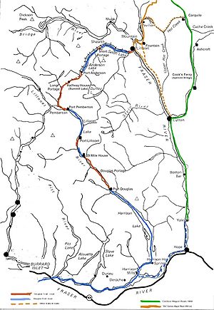
Description

Port Douglas, British Columbia
Port Douglas, sometimes referred to simply as Douglas, is a remote community in British Columbia, Canada at the head of Harrison Lake, which is the head of river navigation from the Strait of Georgia...
, at the head of Harrison Lake
Harrison Lake
Harrison Lake is the largest lake in the southern Coast Mountains of Canada, being about 250 square kilometres in area. It is about 60 km in length and at its widest almost 9 km across. Its southern end, at the resort community of Harrison Hot Springs, is c. 95 km east of...
and the head of river navigation from the Strait of Georgia
Strait of Georgia
The Strait of Georgia or the Georgia Strait is a strait between Vancouver Island and the mainland coast of British Columbia, Canada. It is approximately long and varies in width from...
. From there a land portion of the route follows the lower Lillooet River
Lillooet River
The Lillooet River is a major river of the southern Coast Mountains of British Columbia. It begins at Silt Lake, on the southern edge of the Lillooet Crown Icecap about 80 kilometres northwest of Pemberton and about 85 kilometres northwest of Whistler...
to Port Lillooet at the south end of Lillooet Lake
Lillooet Lake
Lillooet Lake is a lake in British Columbia, Canada about 25 km in length and about 33.5 square kilometres in area. It is about 95 km downstream from the source of the Lillooet River, which resumes its course after leaving Little Lillooet Lake, aka Tenas Lake...
, where steamers and canoes carried travellers to Port Pemberton, at the mouth of the Birkenhead River
Birkenhead River
The Birkenhead River, formerly known as the Portage River, the Pole River and the Mosquito River, is a major tributary of the Lillooet River, which via Harrison Lake and the Harrison River is one of the major tributaries of the lower Fraser River...
near present-day Mount Currie
Mount Currie, British Columbia
Mount Currie is a small community in British Columbia, 164 kilometres north-west of Vancouver and 40 kilometres north-west of Whistler along Highway 99....
.
The next land portion of the route, known as the Long Portage or the Pemberton Portage
Pemberton Pass
Pemberton Pass, , also formerly known as Mosquito Pass, is the lowest point on the divide between the Lillooet and Fraser River drainages, located at Birken, British Columbia, Canada, in the principal valley connecting and between Pemberton and Lillooet...
, follows the lower Birkenhead River
Birkenhead River
The Birkenhead River, formerly known as the Portage River, the Pole River and the Mosquito River, is a major tributary of the Lillooet River, which via Harrison Lake and the Harrison River is one of the major tributaries of the lower Fraser River...
then diverges from it to Birken Lake (aka Summit Lake or Gates Lake) and then via the Gates River
Gates River
The Gates River is a short river in the Lillooet Country of the Southern Interior of British Columbia, Canada. Approximately 14.5 km in length, it flows generally northeast from the outlet of Birken Lake to its mouth at the head of Anderson Lake...
to present-day D'Arcy
D'Arcy, British Columbia
D'Arcy is an unincorporated community in the Canadian province of British Columbia, approximately 150 kilometres northeast of the city of Vancouver...
at the head of Anderson Lake, then known as Port Anderson. From there a motley variety of watercraft, including a few small steamers and the ubiquitous native canoe
Canoe
A canoe or Canadian canoe is a small narrow boat, typically human-powered, though it may also be powered by sails or small electric or gas motors. Canoes are usually pointed at both bow and stern and are normally open on top, but can be decked over A canoe (North American English) or Canadian...
, ferried travellers to the Short Portage (today known as Seton Portage
Seton Portage, British Columbia
Seton Portage is a historic rural community in British Columbia, Canada, that is about 25 km west of Lillooet, located between Seton Lake and Anderson Lake. "The Portage" was formed about 10,000 years ago when the flank of the Cayoosh Range, which is the south flank of the valley, let go and...
). There packers and ultimately a short mule-drawn "railway" shuttled men and freight to the head of Seton Lake
Seton Lake
Seton Lake is a freshwater fjord draining east via the Seton River into the Fraser River at the town of Lillooet, British Columbia, about 22 km long and 243 m in elevation and 26.2 square kilometres in area...
, where another collection of steamers carried them to the foot of that lake and a final five-mile wagon road to the boomtowns of Cayoosh Flat, Parsonville and Marysville (today's Lillooet
Lillooet, British Columbia
Lillooet is a community on the Fraser River in western Canada, about up the British Columbia Railway line from Vancouver. Situated at an intersection of deep gorges in the lee of the Coast Mountains, it has a dry climate- of precipitation is recorded annually at the town's weather station,...
).
In response to the Cariboo Gold Rush
Cariboo Gold Rush
The Cariboo Gold Rush was a gold rush in the Canadian province of British Columbia. Although the first gold discovery was made in 1859 at Horsefly Creek, followed by more strikes at Keithley Creek and Antler Horns lake in 1860, the actual rush did not begin until 1861, when these discoveries were...
, a toll road
Toll road
A toll road is a privately or publicly built road for which a driver pays a toll for use. Structures for which tolls are charged include toll bridges and toll tunnels. Non-toll roads are financed using other sources of revenue, most typically fuel tax or general tax funds...
from there to Fort Alexandria was built by entrepreneur Gustavus Blin Wright
Gustavus Blin Wright
Gustavus Blin Wright was a pioneer roadbuilder and entrepreneur in British Columbia, Canada. His biggest achievement was building the Old Cariboo Road to the Cariboo gold fields, from Lillooet to Fort Alexandria, but he was also a partner in a freighting firm that operated on the Douglas Road, he...
, followed the Fraser Canyon
Fraser Canyon
The Fraser Canyon is an 84 km landform of the Fraser River where it descends rapidly through narrow rock gorges in the Coast Mountains en route from the Interior Plateau of British Columbia to the Fraser Valley...
for about twenty miles, then cut up eastwards onto the Cariboo Plateau
Cariboo Plateau
The Cariboo Plateau is a volcanic plateau in south-central British Columbia, Canada. It is part of the Fraser Plateau that itself is a northward extension of the North American Plateau...
via the town of Clinton
Clinton, British Columbia
Clinton is a village in British Columbia, Canada, located approximately 40 km northwest of Cache Creek and 30 km south of 70 Mile House.It is considered by some to straddle the southern edge of the Cariboo country of British Columbia, although others consider Ashcroft-Cache Creek, Lillooet, Savona,...
, where the later Cariboo Wagon Road met the older route. Lillooet
Lillooet, British Columbia
Lillooet is a community on the Fraser River in western Canada, about up the British Columbia Railway line from Vancouver. Situated at an intersection of deep gorges in the lee of the Coast Mountains, it has a dry climate- of precipitation is recorded annually at the town's weather station,...
was numbered as "Mile 0" of this road, with its roadhouses taking their name from their distance from a certain point on Lillooet
Lillooet, British Columbia
Lillooet is a community on the Fraser River in western Canada, about up the British Columbia Railway line from Vancouver. Situated at an intersection of deep gorges in the lee of the Coast Mountains, it has a dry climate- of precipitation is recorded annually at the town's weather station,...
's Main Street.
See also
- Cariboo camelsCariboo camelsThe saga of the Cariboo camels is one of the most interesting pages in the history of British Columbia. The Bactrian camels were used on the Douglas Road and the Old Cariboo Road in 1862 and 1863 to haul freight during the Cariboo Gold Rush...
- Vessels of the Lakes RouteVessels of the Lakes RouteThe Lakes Route is an alternate name for the Douglas Road, which was the first formally-designated "road" into the Interior of British Columbia, Canada from its Lower Mainland area flanking the Lower Fraser River...
- Cariboo RoadCariboo RoadThe Cariboo Road was a project initiated in 1860 by the colonial Governor of British Columbia, James Douglas...
- Old Cariboo RoadOld Cariboo RoadThe Old Cariboo Road is a reference to the original wagon road to the Cariboo gold fields in what is now the Canadian province of British Columbia...
- Whatcom TrailWhatcom TrailThe Whatcom Trail was an overland trail from the Puget Sound area of Washington Territory during the Fraser Canyon Gold Rush of 1858. Named for the then-chief of the Nooksack people on Bellingham Bay, where the trail began at Fairhaven , the route used went via a route known as the Columbia...
- Okanagan TrailOkanagan TrailThe Okanagan Trail was an inland route to the Fraser Canyon Gold Rush from the Lower Columbia region of the Washington and Oregon Territories in 1858-1859...
- River TrailRiver Trail (British Columbia)The River Trail was a main route for travel in the colonial era of what is now the Canadian province of British Columbia, running northwards along the Fraser River from to present day Lillooet to Big Bar, British Columbia and points beyond in the Cariboo District...
- Lillooet Cattle TrailLillooet Cattle TrailThe Lillooet Cattle Trail, also known as the Lillooet-Burrard Cattle Trail and also as the Lillooet Trail , was an unusual and daring public works undertaking by the Province of British Columbia in the 1877, and was the largest 19th Century public works expenditure at $35,000 of the new province...
- Similkameen Trail
- Dewdney Trail
- Hudson's Bay Brigade TrailHudson's Bay Brigade TrailThe Hudson's Bay Brigade Trail, sometimes referred to simply as the Brigade Trail, refers to one of two routes used by Hudson's Bay Company fur traders to transport furs, goods and supplies between coastal and Columbia District headquarters at Fort Vancouver and those in New Caledonia and also in...