

Scots' Dike
Encyclopedia
The Scots' Dike or dyke is a three and a half mile / 5.25 km long linear earthwork, constructed by the English
and the Scots
in the year 1552 to mark the division of the Debatable lands
and thereby settle the exact boundary between the Kingdoms of Scotland
and England
.
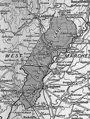
, also known as "Debatable ground", "Batable ground", or "Threpe" - Scots for something that is argued over - were in the West Marches
, bounded on the west by the River Sark
, to the east by the River Esk
and Liddel Water
, on the north by the Bruntshiell Moor
and Tarras Moss
, and on the south by the estuary of the Esk. The area was about ten miles from north to south and three and a half from east to west at its widest part. Canonbie
was the main population centre within the debatable lands.
These lands were finally divided between the English and Scottish Crowns by an agreement arbitrated by the French
Ambassador. The physical border constructed came to be known as the "Scots' Dike", the "March Dike" or more recently the 'Scotsdike plantation'. The terminal points of the dike were marked by square stones bearing the royal arms of England and Scotland, however these markers have disappeared, possibly having been broken up for building nearby cottages. Spaced along the centre of the bank are a number of small unmarked boundary stones of uncertain date, some of which have fallen.
maps today. The western Anglo-Scottish Border was more formally agreed in Edward II
's reign with David II of Scotland
in 1330, to run along the course of the Esk
and Liddel
from Gretna
to Kershopefoot
to delineate between the English and Scottish West Marches. In practice, however, this region was controlled by Wardens of the marches who usually held the land in their own right and met at designated sites, such as the Lochmaben Stone
to discuss and settle disputes.
 In Scotland the Maxwells, Johnstons
and Scotts
secured the Scottish West March to Gretna and Langholm
, and in England the region was controlled from Carlisle. The Esk basin at Arthuret
was a marshy bogland which was difficult to police, with the Scottish jurisdiction having difficulty policing their side from Gretna to Canonbie
. The Debatable Land arose because the Graemes
, Armstrongs
, Elliots and Bells were too powerful, and the Wardens largely left them alone. These four families raided equally in both England and Scotland, claiming allegiance to neither country; it actually suited both Governments to have such a "buffer" zone, so the district became a sort of no-mans land, where neither country could or would enforce their jurisdiction.
Eventually the general lawlessness spilled over and both Wardens demanded that the Debateable Land be eradicated. So in 1552 the French ambassador was appointed to finalise the Border line, together with Lord Wharton
(of the Battle of Solway Moss
fame) and Sir Thomas Chaloner
nominated and appointed from England; Sir James Douglas
of Drumlanrig
and Richard Maitland
of Lethington
likewise nominated and appointed from Scotland. The Commissioners agreed to a compromise demarcation line suggested by the French Ambassador, and issued a final declaration that the borderline would run from the Sark
to a point on Esk, opposite the house of Fergus Greme; a cross pattee at each end and styled 'this is the least and fynal lyne of the particion concluded xxiiij Septembris 1552.'
and the eastern half (Armstrongs and Elliots) to Scotland under Queen Mary. England received the main western road into Scotland, while Scotland received little else but moorland; however, the Scots portion was the larger when the dike came to be built.

 The various sources state that the terminal stones were square stones bearing the royal arms of England and Scotland, however the Commissioners stated that .....a cross pattee at each end and styled 'this is the least and fynal lyne of the particion concluded xxiiij Septembris 1552.' A cross pattée
is a type of cross
that has arms which are narrow at the centre, and broader at the perimeter. The name comes from the fact that the shape of each arm of the cross was thought to resemble a paw (French patte). There are several variants of the cross pattée, however it is not known whether these were ever actually made for installation at the dike's terminal points. What fate befell the stones that were made is not recorded. The 19th-century OS maps mark a number of boundary stones which are very unlikely to be contemporary with the terminal stones.
's 'Scotiae Regnum' of 1595 shows the Scots' Dike but does not name it.
Robert Gordon's manuscript map of 1636 - 52 clearly marks the dike but does not name it or indicate any farms etc. associated with it.
Blaeu's Atlas of Scotland (1654) refers to the Dike as the 'March (dyik) Dike' and indicates a dwelling named 'March-dike (dyik)-foot'. Herman Moll's (died 1732) map gives the name 'March dyck', however he oddly does not show the 'March Dike' as being the borderline.
General Roy
's Military Survey of Scotland undertaken from 1747 - 1752, clearly marks the 'Scots Dyke' by that name for the first time, shown as a set of parallel lines running from the Sark to the Esk.
The name 'Scots' Dike' was in use by Roy's time, that is the mid 18th-century, but previously 'March Dike' seems to have been favoured. It is not clear why the name Scots' stuck as the Scots might just as well have called it the 'English Dyke'; interestingly there has been an 'Englishtown farm' marked since at least Roy's time.
The Blaeu Atlas of Scotland (1654) is the first to indicates a named dwelling, this being 'March-dike (dyik)-foot'. General Roy's Military Survey of Scotland undertaken from 1747 - 1752, indicates both 'Craws Know', 'English town' and 'Scots Dyke', however March-dike-foot is not shown by that name.
William Crawford's map of 1804 shows a dwelling called Scots dyke and another called Crossdyke which is no longer marked as such by the 1920s. Thomas Moule
's map of 1830 shows a 'Dykestown' which is not indicated elsewhere.
The 1901 OS marks a dwelling named 'Roamyrigg' at the Sark end of the dike, lying within part of what had been woodland with a boundary marker nearby (now fallen). This dwelling is not shown on the 1952 OS or at any later date.
) between the rivers Sark
and Esk
and forms the border between England and Scotland for that length.
(1914 - 1918) the section within the Scotsdike Plantation was largely intact, however tree felling operations, such as the laying down of temporary railway lines on top of the Dike and the hauling of cut tree trunks, caused considerable damage or even complete destruction in places. The period between 1916 and 1926 seems to have been the worst, despite complaints having been lodged regarding the wholesale destruction of a national monument.
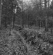 The dike is only traceable within the Scots Dike Plantation, consisting of a bank, with slight ditches on either side, which varies in width from 5.8 m at the west end to 3.3 m at the east end, standing to a maximum height of 0.8 m. The E and W ends cannot be traced, and in places the ditches have silted up while elsewhere they have been re-cut.
In June 1999 English Heritage field investigators visited as part of a National survey pilot project. They describe the monument as lying at the centre of a belt of woodland, comprising spruce plantation to the north of the dike and deciduous woodland to its south. Parts of the plantation had been felled recently, but the dense vegetation rendered detailed survey impossible and investigation was limited to surface examination of the dike. The remains of the linear earthwork, between NY 3346 7396 and NY 3850 7325, consisted mainly of flat-topped bank flanked by a ditch on either side. The form and preservation of these features varied considerably along the length of the dike and it was concluded that little of the monument survived in its original form, however its course is preserved in later boundaries and drainage ditches.
Long sections of the ditches, especially the northern ditch, have been re-cut to provide drainage for the conifer plantation, although in places the modern drainage appears to have been cut through the centre of the dike. Elsewhere, for example at NY 3490 7385, the feature have been almost plough-levelled, the ditches having disappeared and the bank surviving as little more than a rise in the ground. Between NY 3544 7375 and NY 3570 7370, where the Glenzier
Beck crosses the course of the dike, there are no traces of the earthwork; whether it has simply not survived or whether the dyke was ever constructed across the slack was not apparent. At a number of points along the length of the dike - most notably at approximately NY 34457390 and NY 36357355 - there is a disjointure in the earthwork which is suggestive of a shift in the line of the original boundary, perhaps due to later land use. At the extreme western end of the dike, between approximately NY 3346 7396 and NY 3390 7392, a second, much slighter bank and ditch lies to the south of the main earthwork but may be nothing more than later drainage. The course of the dike between the western end of Scotsdike Plantation and the River Sark could not be traced on the ground but it was thought that it followed the extant field boundary to the south of Craw's Knowe farm.
was opened on 25 October 1861 by the Border Union Railway
as 'Scotsdyke' and later renamed 'Scotch Dyke'. It was on the English side of the present border
, and closed on 2 May 1949. It was a two-platform station with a level crossing to its north. Today (2006) the former station retains its building and platforms. The canopy of the building has a script reading "Speed and comfort by rail" with its 'British Railways' logo.
. It is of unknown date and consists of a linear ditch and a bank, showing some of the characteristics of an Anglo-Saxon territorial boundary.
in Scotland.
In Scotland a dike is a stone wall, but in England a dyke is a ditch.
The Battle of Solway Moss
took place in the Debatable land near Gretna
on 24 November 1542. It was described as a rout in which the Scots lost and shortly after James V of Scotland
died, although he had not been present at the battle in person.
English people
The English are a nation and ethnic group native to England, who speak English. The English identity is of early mediaeval origin, when they were known in Old English as the Anglecynn. England is now a country of the United Kingdom, and the majority of English people in England are British Citizens...
and the Scots
Scottish people
The Scottish people , or Scots, are a nation and ethnic group native to Scotland. Historically they emerged from an amalgamation of the Picts and Gaels, incorporating neighbouring Britons to the south as well as invading Germanic peoples such as the Anglo-Saxons and the Norse.In modern use,...
in the year 1552 to mark the division of the Debatable lands
Debatable Lands
The Debatable Lands, also known as Debatable ground, batable ground or thriep lands, was land lying between Scotland and England, formerly in question to which it belonged, when they were distinct kingdoms...
and thereby settle the exact boundary between the Kingdoms of Scotland
Kingdom of Scotland
The Kingdom of Scotland was a Sovereign state in North-West Europe that existed from 843 until 1707. It occupied the northern third of the island of Great Britain and shared a land border to the south with the Kingdom of England...
and England
Kingdom of England
The Kingdom of England was, from 927 to 1707, a sovereign state to the northwest of continental Europe. At its height, the Kingdom of England spanned the southern two-thirds of the island of Great Britain and several smaller outlying islands; what today comprises the legal jurisdiction of England...
.
Introduction
The Debatable LandsDebatable Lands
The Debatable Lands, also known as Debatable ground, batable ground or thriep lands, was land lying between Scotland and England, formerly in question to which it belonged, when they were distinct kingdoms...
, also known as "Debatable ground", "Batable ground", or "Threpe" - Scots for something that is argued over - were in the West Marches
Marches
A march or mark refers to a border region similar to a frontier, such as the Welsh Marches, the borderland between England and Wales. During the Frankish Carolingian Dynasty, the word spread throughout Europe....
, bounded on the west by the River Sark
River Sark
Disambiguation: for other meanings, please see Sark The River Sark or Sark Water is a river best known for forming part of the western border between Scotland and England...
, to the east by the River Esk
River Esk, Dumfries and Galloway
The River Esk is a river in Dumfries and Galloway, Scotland, that flows into the Solway Firth. It also flows for a small way through the English county of Cumbria before entering the Solway....
and Liddel Water
Liddel Water
Liddel Water is a river running through southern Scotland and northern England, for much of its course forming the border between the two countries, and was formerly one of the boundaries of the Debatable Lands....
, on the north by the Bruntshiell Moor
Moorland
Moorland or moor is a type of habitat, in the temperate grasslands, savannas, and shrublands biome, found in upland areas, characterised by low-growing vegetation on acidic soils and heavy fog...
and Tarras Moss
Bog
A bog, quagmire or mire is a wetland that accumulates acidic peat, a deposit of dead plant material—often mosses or, in Arctic climates, lichens....
, and on the south by the estuary of the Esk. The area was about ten miles from north to south and three and a half from east to west at its widest part. Canonbie
Canonbie
Canonbie is a small village in Dumfries and Galloway in south west Scotland, six miles south of Langholm and two miles north of the Anglo-Scottish border. It is on the A7 road from Carlisle to Edinburgh, and the River Esk flows through it...
was the main population centre within the debatable lands.
These lands were finally divided between the English and Scottish Crowns by an agreement arbitrated by the French
Early Modern France
Kingdom of France is the early modern period of French history from the end of the 15th century to the end of the 18th century...
Ambassador. The physical border constructed came to be known as the "Scots' Dike", the "March Dike" or more recently the 'Scotsdike plantation'. The terminal points of the dike were marked by square stones bearing the royal arms of England and Scotland, however these markers have disappeared, possibly having been broken up for building nearby cottages. Spaced along the centre of the bank are a number of small unmarked boundary stones of uncertain date, some of which have fallen.
Borderline
In 1222 a commission of six representatives from each kingdom attempted to fix the border line, and one proposed by the English commissioners more or less equates to that which is shown on Ordnance SurveyOrdnance Survey
Ordnance Survey , an executive agency and non-ministerial government department of the Government of the United Kingdom, is the national mapping agency for Great Britain, producing maps of Great Britain , and one of the world's largest producers of maps.The name reflects its creation together with...
maps today. The western Anglo-Scottish Border was more formally agreed in Edward II
Edward II of England
Edward II , called Edward of Caernarfon, was King of England from 1307 until he was deposed by his wife Isabella in January 1327. He was the sixth Plantagenet king, in a line that began with the reign of Henry II...
's reign with David II of Scotland
David II of Scotland
David II was King of Scots from 7 June 1329 until his death.-Early life:...
in 1330, to run along the course of the Esk
River Esk, Dumfries and Galloway
The River Esk is a river in Dumfries and Galloway, Scotland, that flows into the Solway Firth. It also flows for a small way through the English county of Cumbria before entering the Solway....
and Liddel
Liddel Water
Liddel Water is a river running through southern Scotland and northern England, for much of its course forming the border between the two countries, and was formerly one of the boundaries of the Debatable Lands....
from Gretna
Gretna
-Places:In Scotland:*Gretna, Scotland in Dumfries and Galloway*Gretna GreenIn Canada:*Gretna, ManitobaIn the United States:*Gretna, Florida*Gretna, Louisiana*Gretna, Nebraska*Mount Gretna, Pennsylvania*Mount Gretna Heights, Pennsylvania...
to Kershopefoot
Kershopefoot
Kershopefoot is a small village in Cumbria, England. It is located very close to the Scotland-England border and is near the Kershope Burn and the Liddel Water....
to delineate between the English and Scottish West Marches. In practice, however, this region was controlled by Wardens of the marches who usually held the land in their own right and met at designated sites, such as the Lochmaben Stone
Lochmaben Stone
The Lochmaben Stone is a megalith standing in a field, nearly a mile west of the Sark mouth on the Solway Firth, three hundred yards or so above high water mark on the farm of Old Graitney in Dumfries & Galloway in Scotland. Map reference: NY 3123 6600. The area is also known as Stormont...
to discuss and settle disputes.
Clan Johnstone
-Origin of the name:Clan Johnstone is a Lowland Scottish clan. They were involved in many battles on the Scottish borders.Johnstone comes from "John's toun", not "John's stone" or "John's son." Historically, "Johnston" has been an alternate spelling of the surname...
and Scotts
Clan Scott
Clan Scott is a Scottish clan. Clan Scott is not a Highland clan but Lowland, from the Borders region of Scotland. Families and clans from this area prefer to be known as Borderers instead of Lowlanders.-Origins:...
secured the Scottish West March to Gretna and Langholm
Langholm
Langholm , also known colloquially as the "Muckle Toon", is a burgh in Dumfries and Galloway, Scotland, on the River Esk and the A7 road.- History:...
, and in England the region was controlled from Carlisle. The Esk basin at Arthuret
Arthuret
Arthuret is a civil parish in the Carlisle district of Cumbria, England. According to the 2001 census it had a population of 2,434. The parish includes the small town of Longtown and the village of Easton...
was a marshy bogland which was difficult to police, with the Scottish jurisdiction having difficulty policing their side from Gretna to Canonbie
Canonbie
Canonbie is a small village in Dumfries and Galloway in south west Scotland, six miles south of Langholm and two miles north of the Anglo-Scottish border. It is on the A7 road from Carlisle to Edinburgh, and the River Esk flows through it...
. The Debatable Land arose because the Graemes
Clan Graham
Clan Graham is a Scottish clan who had territories in both the Scottish Highlands and Lowlands.-Origins:Legend has it that the first Graham was one Gramus who forced a breach in the Roman Antonine wall known as Graeme's Dyke in 420 A.D...
, Armstrongs
Clan Armstrong
Clan Armstrong is an armigerous clan whose origins lie in Cumberland, south of the frontier between Scotland and England which was officially established in 1237....
, Elliots and Bells were too powerful, and the Wardens largely left them alone. These four families raided equally in both England and Scotland, claiming allegiance to neither country; it actually suited both Governments to have such a "buffer" zone, so the district became a sort of no-mans land, where neither country could or would enforce their jurisdiction.
Eventually the general lawlessness spilled over and both Wardens demanded that the Debateable Land be eradicated. So in 1552 the French ambassador was appointed to finalise the Border line, together with Lord Wharton
Thomas Wharton, 1st Baron Wharton
Thomas Wharton, 1st Baron Wharton was an English nobleman and a follower of King Henry VIII of England. He is best known for his victory at Solway Moss on 24 November 1542 for which he was given a barony.-Early life:...
(of the Battle of Solway Moss
Battle of Solway Moss
The Battle of Solway Moss took place on Solway Moss near the River Esk on the English side of the Anglo-Scottish Border in November 1542 between forces from England and Scotland.-Background:...
fame) and Sir Thomas Chaloner
Thomas Chaloner (statesman)
Sir Thomas Chaloner was an English statesman and poet.-Life:He was the son of Roger Chaloner, mercer of London, a descendant of the Denbighshire Chaloners...
nominated and appointed from England; Sir James Douglas
James Douglas, 3rd Earl of Morton
James Douglas, 3rd Earl of Morton was a son of John Douglas, 2nd Earl of Morton and a grandson of James Douglas, 1st Earl of Morton and Joan of Scotland, a daughter of James I of Scotland. He married Catherine Stewart, an illegitimate daughter of King James IV of Scotland by his mistress Marion...
of Drumlanrig
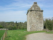
Drumlanrig Castle
Drumlanrig Castle sits on the Queensberry Estate in Scotland's Dumfries and Galloway.The Castle is the Dumfriesshire family home to the Duke and Duchess of Buccleuch and Queensberry...
and Richard Maitland
Richard Maitland
Sir Richard Maitland of Lethington and Thirlstane was a Senator of the College of Justice, an Ordinary Lord of Session from 1561 until 1584, and notable Scottish poet. He was served heir to his father, Sir William Maitland of Lethington, Haddingtonshire, and Thirlestane, Berwickshire, on 15...
of Lethington
Lennoxlove House
Lennoxlove House is a historic house set in woodlands half a mile south of Haddington in East Lothian, Scotland. The house comprises a 15th-century tower, originally known as Lethington, and has been extended several times, principally in the 17th, 19th and 20th centuries...
likewise nominated and appointed from Scotland. The Commissioners agreed to a compromise demarcation line suggested by the French Ambassador, and issued a final declaration that the borderline would run from the Sark
River Sark
Disambiguation: for other meanings, please see Sark The River Sark or Sark Water is a river best known for forming part of the western border between Scotland and England...
to a point on Esk, opposite the house of Fergus Greme; a cross pattee at each end and styled 'this is the least and fynal lyne of the particion concluded xxiiij Septembris 1552.'
Division of the Debatable Lands
The Debatable Land was physically divided into two halves by a man-made ditch called the 'Scots' Dike', giving the western half (Graemes and Bells) to England under Edward VIEdward VI of England
Edward VI was the King of England and Ireland from 28 January 1547 until his death. He was crowned on 20 February at the age of nine. The son of Henry VIII and Jane Seymour, Edward was the third monarch of the Tudor dynasty and England's first monarch who was raised as a Protestant...
and the eastern half (Armstrongs and Elliots) to Scotland under Queen Mary. England received the main western road into Scotland, while Scotland received little else but moorland; however, the Scots portion was the larger when the dike came to be built.
Construction
The method adopted to dig the Scots' Dike was to dig two parallel ditches, and throw the material excavated therefrom into the intervening space, thus forming an earthen mound of varying height. There is no evidence of stone having been used. East of Crawsknow farm, the Dike appears originally to have been about 12 feet broad and 3 or 4 feet high, however it is variable e.g. at one point the Dike takes the form of a narrow strip and then becomes a double ditch with a space of about 30 ft separating them. There is little evidence that the dike has ever been used as a footpath. It may be that two teams built the dike, possibly one from each kingdom, with one starting from the west and another from the east. When the teams came close enough to each other they seem to have been about 21 feet out of their bearings and a correction in the line of the Dike became necessary.Terminal stones
Cross pattée
A cross pattée is a type of cross which has arms narrow at the centre, and broader at the perimeter. An early English example from the start of the age of heraldry proper A cross pattée (or "cross patty", known also as "cross formée/formy") is a type of cross which has arms narrow at the...
is a type of cross
Cross
A cross is a geometrical figure consisting of two lines or bars perpendicular to each other, dividing one or two of the lines in half. The lines usually run vertically and horizontally; if they run obliquely, the design is technically termed a saltire, although the arms of a saltire need not meet...
that has arms which are narrow at the centre, and broader at the perimeter. The name comes from the fact that the shape of each arm of the cross was thought to resemble a paw (French patte). There are several variants of the cross pattée, however it is not known whether these were ever actually made for installation at the dike's terminal points. What fate befell the stones that were made is not recorded. The 19th-century OS maps mark a number of boundary stones which are very unlikely to be contemporary with the terminal stones.
Name of the dike
MercatorGerardus Mercator
thumb|right|200px|Gerardus MercatorGerardus Mercator was a cartographer, born in Rupelmonde in the Hapsburg County of Flanders, part of the Holy Roman Empire. He is remembered for the Mercator projection world map, which is named after him...
's 'Scotiae Regnum' of 1595 shows the Scots' Dike but does not name it.
Robert Gordon's manuscript map of 1636 - 52 clearly marks the dike but does not name it or indicate any farms etc. associated with it.
Blaeu's Atlas of Scotland (1654) refers to the Dike as the 'March (dyik) Dike' and indicates a dwelling named 'March-dike (dyik)-foot'. Herman Moll's (died 1732) map gives the name 'March dyck', however he oddly does not show the 'March Dike' as being the borderline.
General Roy
William Roy
Major-General William Roy FRS was a Scottish military engineer, surveyor, and antiquarian. He was an innovator who applied new scientific discoveries and newly emerging technologies to the accurate geodetic mapping of Great Britain....
's Military Survey of Scotland undertaken from 1747 - 1752, clearly marks the 'Scots Dyke' by that name for the first time, shown as a set of parallel lines running from the Sark to the Esk.
The name 'Scots' Dike' was in use by Roy's time, that is the mid 18th-century, but previously 'March Dike' seems to have been favoured. It is not clear why the name Scots' stuck as the Scots might just as well have called it the 'English Dyke'; interestingly there has been an 'Englishtown farm' marked since at least Roy's time.
Place-names associated with the dike
| Etymology |
| A Roan in Scots is a tangle of brushwood or thorns and a 'Rig' is a section of a ploughed field. Roamyrigg seems a particularly accurate description of this site. ' |
The Blaeu Atlas of Scotland (1654) is the first to indicates a named dwelling, this being 'March-dike (dyik)-foot'. General Roy's Military Survey of Scotland undertaken from 1747 - 1752, indicates both 'Craws Know', 'English town' and 'Scots Dyke', however March-dike-foot is not shown by that name.
William Crawford's map of 1804 shows a dwelling called Scots dyke and another called Crossdyke which is no longer marked as such by the 1920s. Thomas Moule
Thomas Moule
Thomas Moule was an English antiquarian, writer on heraldry, and map-maker. He is best known for his popular and highly decorated county maps of England, steel-engraved and first published separately between 1830 and 1832....
's map of 1830 shows a 'Dykestown' which is not indicated elsewhere.
The 1901 OS marks a dwelling named 'Roamyrigg' at the Sark end of the dike, lying within part of what had been woodland with a boundary marker nearby (now fallen). This dwelling is not shown on the 1952 OS or at any later date.
Location
The Dike runs from NY 3307 7367 to NY 3872 7319 (British national grid reference systemBritish national grid reference system
The Ordnance Survey National Grid reference system is a system of geographic grid references used in Great Britain, different from using latitude and longitude....
) between the rivers Sark
River Sark
Disambiguation: for other meanings, please see Sark The River Sark or Sark Water is a river best known for forming part of the western border between Scotland and England...
and Esk
River Esk, Dumfries and Galloway
The River Esk is a river in Dumfries and Galloway, Scotland, that flows into the Solway Firth. It also flows for a small way through the English county of Cumbria before entering the Solway....
and forms the border between England and Scotland for that length.
Damage
It is clear from OS maps that since at least 1862 the majority of the length of the Scots' Dike has been afforested. Prior to the First World WarWorld War I
World War I , which was predominantly called the World War or the Great War from its occurrence until 1939, and the First World War or World War I thereafter, was a major war centred in Europe that began on 28 July 1914 and lasted until 11 November 1918...
(1914 - 1918) the section within the Scotsdike Plantation was largely intact, however tree felling operations, such as the laying down of temporary railway lines on top of the Dike and the hauling of cut tree trunks, caused considerable damage or even complete destruction in places. The period between 1916 and 1926 seems to have been the worst, despite complaints having been lodged regarding the wholesale destruction of a national monument.
Visual remains
In June 1999 English Heritage field investigators visited as part of a National survey pilot project. They describe the monument as lying at the centre of a belt of woodland, comprising spruce plantation to the north of the dike and deciduous woodland to its south. Parts of the plantation had been felled recently, but the dense vegetation rendered detailed survey impossible and investigation was limited to surface examination of the dike. The remains of the linear earthwork, between NY 3346 7396 and NY 3850 7325, consisted mainly of flat-topped bank flanked by a ditch on either side. The form and preservation of these features varied considerably along the length of the dike and it was concluded that little of the monument survived in its original form, however its course is preserved in later boundaries and drainage ditches.
| Etymology |
| A Craw in Scots is a rook, carrion or hooded crow. A 'Knowe' is a knoll or low hill. Crawknowe is therefore the 'Hill of the Crow.' |
Long sections of the ditches, especially the northern ditch, have been re-cut to provide drainage for the conifer plantation, although in places the modern drainage appears to have been cut through the centre of the dike. Elsewhere, for example at NY 3490 7385, the feature have been almost plough-levelled, the ditches having disappeared and the bank surviving as little more than a rise in the ground. Between NY 3544 7375 and NY 3570 7370, where the Glenzier
Glenzier
Glenzier is a village in Dumfries and Galloway, Scotland.-See also:*Scots dike and the Glenzier burn....
Beck crosses the course of the dike, there are no traces of the earthwork; whether it has simply not survived or whether the dyke was ever constructed across the slack was not apparent. At a number of points along the length of the dike - most notably at approximately NY 34457390 and NY 36357355 - there is a disjointure in the earthwork which is suggestive of a shift in the line of the original boundary, perhaps due to later land use. At the extreme western end of the dike, between approximately NY 3346 7396 and NY 3390 7392, a second, much slighter bank and ditch lies to the south of the main earthwork but may be nothing more than later drainage. The course of the dike between the western end of Scotsdike Plantation and the River Sark could not be traced on the ground but it was thought that it followed the extant field boundary to the south of Craw's Knowe farm.
Access
The site is marked as an ancient monument on some tourist maps and 'Solway Heritage' unveiled a new access point to the dike in 1999. No interpretation or formal access to the dike itself exists at present (2006). The easiest point of informal access is via the minor road at the Sark end of the dike.Status
The Scot's Dike is recorded in the English National Archaeological Record as ancient monument NY37SE 14, and in Scotland it is likewise recorded by the RCAHMS as NMRS number: NY37SE 6.Scotch Dike railway station
A railway station named Scotch DykeScotch Dyke railway station
Scotch Dyke railway station was a railway station in Cumberland close to the Scots' Dike, the traditional border with Scotland.- History :The station was opened on 25 October 1861 by the Border Union Railway as 'Scotsdyke' and later renamed 'Scotch Dyke'. It was a two-platform station with a level...
was opened on 25 October 1861 by the Border Union Railway
Border Union Railway
The Border Union Railway was a railway line in south of Scotland. It was authorised on 21 July 1859 and advertised as the Waverley Route by the promoters - the North British Railway...
as 'Scotsdyke' and later renamed 'Scotch Dyke'. It was on the English side of the present border
Anglo-Scottish border
The Anglo-Scottish border is the official border and mark of entry between Scotland and England. It runs for 154 km between the River Tweed on the east coast and the Solway Firth in the west. It is Scotland's only land border...
, and closed on 2 May 1949. It was a two-platform station with a level crossing to its north. Today (2006) the former station retains its building and platforms. The canopy of the building has a script reading "Speed and comfort by rail" with its 'British Railways' logo.
Other National Border earthworks
The Countrup Sike at NT 8495 2912 is a much reduced bank, 0.2 m high and 2 m wide, running for less than 20 m, virtually along the line of the Border in a north-west direction. Its true nature remains to be confirmed as this will require more than just field observation.Scots Dike at Richmond
A Scots Dike also exists at Richmond where it runs up to the river SwaleRiver Swale
The River Swale is a river in Yorkshire, England and a major tributary of the River Ure, which itself becomes the River Ouse, emptying into the North Sea via the Humber Estuary....
. It is of unknown date and consists of a linear ditch and a bank, showing some of the characteristics of an Anglo-Saxon territorial boundary.
Miscellany
The term 'lands Debatable' was still being used as late as 1604 by the Supreme Courts of JusticeCollege of Justice
The College of Justice is a term used to describe the Supreme Courts of Scotland, and its associated bodies.The constituent bodies of the supreme courts of Scotland are the Court of Session, the High Court of Justiciary, and the Accountant of Court's Office...
in Scotland.
In Scotland a dike is a stone wall, but in England a dyke is a ditch.
The Battle of Solway Moss
Battle of Solway Moss
The Battle of Solway Moss took place on Solway Moss near the River Esk on the English side of the Anglo-Scottish Border in November 1542 between forces from England and Scotland.-Background:...
took place in the Debatable land near Gretna
Gretna
-Places:In Scotland:*Gretna, Scotland in Dumfries and Galloway*Gretna GreenIn Canada:*Gretna, ManitobaIn the United States:*Gretna, Florida*Gretna, Louisiana*Gretna, Nebraska*Mount Gretna, Pennsylvania*Mount Gretna Heights, Pennsylvania...
on 24 November 1542. It was described as a rout in which the Scots lost and shortly after James V of Scotland
James V of Scotland
James V was King of Scots from 9 September 1513 until his death, which followed the Scottish defeat at the Battle of Solway Moss...
died, although he had not been present at the battle in person.
Further reading
- 1. Graham, T H B (1912) The Debatable Land, Trans. Cumberland Westmorland Antiq Archaeol Soc, New, 12, 1911-12, P. 47 - 48,
- 2. Mack, J L (1923) The Old Scots Dike: its construction, A.D. 1552, and its destruction, 1917-1920, Trans. Hawick Archaeol Soc, 1923, P. 3 - 5.
- 3. RCAHMS (1920) The Royal Commission on the Ancient and Historical Monuments and Constructions of Scotland. Seventh report with inventory of monuments and constructions in the county of Dumfries. Edinburgh, xviii-xix, 30, no. 48.
- 4. RCAHMS (1981 a) The Royal Commission on the Ancient and Historical Monuments of Scotland. The archaeological sites and monuments of Ewesdale and Lower Eskdale, Annandale and Eskdale District, Dumfries and Galloway Region. The archaeological sites and monuments of Scotland series no 13, Edinburgh, 16, no. 76.
- 5. RCAHMS (1997 a). Eastern Dumfriesshire: an archaeological landscape, Edinburgh, 47, P. 327, no. 1940.
External links
- The Debatable lands
- An aerial view of the Scotsdike plantation
- A Researcher's Guide to Local History terminology
See also
- Anglo-Scottish borderAnglo-Scottish borderThe Anglo-Scottish border is the official border and mark of entry between Scotland and England. It runs for 154 km between the River Tweed on the east coast and the Solway Firth in the west. It is Scotland's only land border...
- Offa's DykeOffa's DykeOffa's Dyke is a massive linear earthwork, roughly followed by some of the current border between England and Wales. In places, it is up to wide and high. In the 8th century it formed some kind of delineation between the Anglian kingdom of Mercia and the Welsh kingdom of Powys...
and Wat's DykeWat's DykeWat's Dyke is a 40 mile earthwork running through the northern Welsh Marches from Basingwerk Abbey on the River Dee estuary, passing to the east of Oswestry and onto Maesbury in Shropshire, England...
separating the English kingdom of MerciaMerciaMercia was one of the kingdoms of the Anglo-Saxon Heptarchy. It was centred on the valley of the River Trent and its tributaries in the region now known as the English Midlands...
and the Welsh kingdom of Powys - Hadrian's WallHadrian's WallHadrian's Wall was a defensive fortification in Roman Britain. Begun in AD 122, during the rule of emperor Hadrian, it was the first of two fortifications built across Great Britain, the second being the Antonine Wall, lesser known of the two because its physical remains are less evident today.The...
- Antonine WallAntonine WallThe Antonine Wall is a stone and turf fortification built by the Romans across what is now the Central Belt of Scotland, between the Firth of Forth and the Firth of Clyde. Representing the northernmost frontier barrier of the Roman Empire, it spanned approximately 39 miles and was about ten feet ...
- Berwick-upon-TweedBerwick-upon-TweedBerwick-upon-Tweed or simply Berwick is a town in the county of Northumberland and is the northernmost town in England, on the east coast at the mouth of the River Tweed. It is situated 2.5 miles south of the Scottish border....
- Silesia WallsSilesia WallsSilesia Walls are a line of three parallel earthen ramparts and ditches that run through Lower Silesia in Poland, by the towns Szprotawa and Kożuchów. The walls are about 2.5 metres tall and, at their widest, 47 metres. They run for about 30 kilometres...