
British national grid reference system
Encyclopedia
The Ordnance Survey National Grid reference system is a system of geographic grid references used in Great Britain
, different from using latitude
and longitude
.
The Ordnance Survey
(OS) devised the national grid reference
system, and it is heavily used in their survey data, and in maps (whether published by the Ordnance Survey or commercial map producers) based on those surveys. Grid references are also commonly quoted in other publications and data sources, such as guide books or government
planning documents.
A number of different systems exist that can provide grid references for locations within the British Isles
: this article describes the system created solely for Great Britain
and its outlying islands (including the Isle of Man
); the Irish grid reference system is a similar system created by the Ordnance Survey of Ireland for the island of Ireland
. The Universal Transverse Mercator coordinate system
(UTM) is used to provide grid references for world-wide locations and this is the system commonly used for the Channel Islands
. European-wide agencies also use UTM when mapping locations, or may use the Military grid reference system
(MGRS) system, or variants thereof.
1830 ellipsoid
), and was introduced after the retriangulation of 1936–1962
.
The Airy ellipsoid is a regional best fit for Britain; more modern mapping tends to use the GRS80 ellipsoid used by the GPS (the Airy ellipsoid assumes the Earth to be about 1 km smaller in diameter than the GRS80 ellipsoid, and to be slightly less flattened). The maps adopt a Transverse Mercator projection
with an origin (the "true" origin) at 49° N
, 2° W
(an offshore point in the English Channel
which lies between the island of Jersey
and the French port of St. Malo
). Over the Airy ellipsoid a straight line grid, the National Grid, is placed with a new false origin (to eliminate negative numbers), creating a 700 km by 1300 km grid. This false origin is located south-west of the Isles of Scilly. The distortion created between the OS grid and the projection is countered by a scale factor in the longitude to create two lines of longitude with zero distortion rather than one. Grid north and true north are only aligned on the 400 km easting of the grid which is 2° W (OSGB36) and approx. 2° 0' 5" W (WGS 84
).
OSGB 36 was also used by Admiralty
nautical chart
s until 2000 after which WGS 84
has been used.
A geodetic
transformation between OSGB 36 and other terrestrial reference systems (like ITRF2000
, ETRS89, or WGS 84
) can become quite tedious if attempted manually. The most common transformation is called the Helmert datum transformation
, which results in a typical 7 m error from true. The definitive transformation from ETRS89 that is published by the OSGB is called the National Grid Transformation OSTN02. This models the detailed distortions in the 1936–1962 retriangulation, and achieves backwards compatibility in grid coordinates to sub-metre accuracy.
and latitude
positions on OSGB 36 are the same as for WGS 84
at a point in the Atlantic Ocean well to the west of Great Britain. In Cornwall
the WGS 84 longitude lines are about 70 metres east of their OSGB 36 equivalents, this value rising gradually to about 120 m east on the east coast of East Anglia
. The WGS 84 latitude lines are about 70 m south of the OSGB 36 lines in South Cornwall
, the difference diminishing to zero in the Scottish Borders
, and then increasing to about 50 m north on the north coast of Scotland
. (NB. If the lines are further east, then the longitude value of any given point is further west. Similarly, if the lines are further south, the values will give the point a more northerly latitude.) The smallest datum shift is on the west coast of Scotland and the greatest in Kent
.
But Great Britain has not shrunk by 100+ metres; a point near Land's End now computes to be 27.6 metres closer to a point near Duncansby Head than it did under OSGB36.
halfway between Dover
and Calais
, the ED50
longitude lines are about 20 m east of the OSGB36 equivalents, and the ED50 latitude lines are about 150 m south of the OSGB36 ones.
, almost all of which lies below mean high tide.
For the second letter, each 500 km square is subdivided into 25 squares of size 100 km by 100 km, each with a letter code from A to Z (omitting I) starting with A in the north-west corner to Z in the south-east corner. These squares are outlined in light grey on the map, with those containing land lettered. The central (2° W) meridian is shown in red.
It would be possible to extend the grid system over Ireland
, completing the S and N squares and introducing what would become the R and M squares (with the arrangement of first letters following the same pattern as for the second letter). However, there is no motion for this at the moment, and the accuracy of the projection would start to diminish in the west of Ireland, more than 8 degrees from the central meridian. Theoretically, the system extends far over the Atlantic Ocean
and well into Western Europe
with square AA near Iceland and square ZZ in northern Italy. In fact, Rockall
is mapped by the Ordnance Survey, but is usually shown as an inset without gridlines on a mainland sheet. However, the grid can be extended to put Rockall in grid square MC as shown in this 1:50,000 mockup.
is . (Grid references may be written with or without spaces, e.g. also NN166712.)
in the Shetland Islands may be given as or .
Another, distinct, form of all-numeric grid reference is an abbreviated alphanumeric reference where the letters are simply omitted, e.g. 166712 for the summit of Ben Nevis. Unlike the numeric references described above, this abbreviated grid reference is incomplete; it gives the location relative to an OS 100×100 km square, but does not specify which square. It is often used informally when the context identifies the OS 2-letter square. For example, within the context of a location known to be on OS Landranger sheet 41 (which extends from NN000500 in the south-west to NN400900 in the north-east) the abbreviated grid reference 166712 is equivalent to NN166712. If working with more than one Landranger sheet, this may also be given as 41/166712.
Alternatively, sometimes numbers instead of the two-letter combinations are used for the 100x100km squares.
The numbering follows a grid index where the tens denote the progress from West to East and the units from South to North. In the north of Scotland, the numbering is modified: the 100 km square to the north of 39 is numbered N30; the square to the north of 49 is N40, etc.
Great Britain
Great Britain or Britain is an island situated to the northwest of Continental Europe. It is the ninth largest island in the world, and the largest European island, as well as the largest of the British Isles...
, different from using latitude
Latitude
In geography, the latitude of a location on the Earth is the angular distance of that location south or north of the Equator. The latitude is an angle, and is usually measured in degrees . The equator has a latitude of 0°, the North pole has a latitude of 90° north , and the South pole has a...
and longitude
Longitude
Longitude is a geographic coordinate that specifies the east-west position of a point on the Earth's surface. It is an angular measurement, usually expressed in degrees, minutes and seconds, and denoted by the Greek letter lambda ....
.
The Ordnance Survey
Ordnance Survey
Ordnance Survey , an executive agency and non-ministerial government department of the Government of the United Kingdom, is the national mapping agency for Great Britain, producing maps of Great Britain , and one of the world's largest producers of maps.The name reflects its creation together with...
(OS) devised the national grid reference
Grid reference
Grid references define locations on maps using Cartesian coordinates. Grid lines on maps define the coordinate system, and are numbered to provide a unique reference to features....
system, and it is heavily used in their survey data, and in maps (whether published by the Ordnance Survey or commercial map producers) based on those surveys. Grid references are also commonly quoted in other publications and data sources, such as guide books or government
Government
Government refers to the legislators, administrators, and arbitrators in the administrative bureaucracy who control a state at a given time, and to the system of government by which they are organized...
planning documents.
A number of different systems exist that can provide grid references for locations within the British Isles
British Isles
The British Isles are a group of islands off the northwest coast of continental Europe that include the islands of Great Britain and Ireland and over six thousand smaller isles. There are two sovereign states located on the islands: the United Kingdom of Great Britain and Northern Ireland and...
: this article describes the system created solely for Great Britain
Great Britain
Great Britain or Britain is an island situated to the northwest of Continental Europe. It is the ninth largest island in the world, and the largest European island, as well as the largest of the British Isles...
and its outlying islands (including the Isle of Man
Isle of Man
The Isle of Man , otherwise known simply as Mann , is a self-governing British Crown Dependency, located in the Irish Sea between the islands of Great Britain and Ireland, within the British Isles. The head of state is Queen Elizabeth II, who holds the title of Lord of Mann. The Lord of Mann is...
); the Irish grid reference system is a similar system created by the Ordnance Survey of Ireland for the island of Ireland
Ireland
Ireland is an island to the northwest of continental Europe. It is the third-largest island in Europe and the twentieth-largest island on Earth...
. The Universal Transverse Mercator coordinate system
Universal Transverse Mercator coordinate system
The Universal Transverse Mercator geographic coordinate system uses a 2-dimensional Cartesian coordinate system to give locations on the surface of the Earth. It is a horizontal position representation, i.e...
(UTM) is used to provide grid references for world-wide locations and this is the system commonly used for the Channel Islands
Channel Islands
The Channel Islands are an archipelago of British Crown Dependencies in the English Channel, off the French coast of Normandy. They include two separate bailiwicks: the Bailiwick of Guernsey and the Bailiwick of Jersey...
. European-wide agencies also use UTM when mapping locations, or may use the Military grid reference system
Military grid reference system
The Military Grid Reference System is the geocoordinate standard used by NATO militaries for locating points on the earth. The MGRS is derived from the UTM grid system and the UPS grid system, but uses a different labeling convention...
(MGRS) system, or variants thereof.
General
The grid is based on the OSGB36 datum (Ordnance Survey Great Britain 1936, based on the AiryGeorge Biddell Airy
Sir George Biddell Airy PRS KCB was an English mathematician and astronomer, Astronomer Royal from 1835 to 1881...
1830 ellipsoid
Reference ellipsoid
In geodesy, a reference ellipsoid is a mathematically-defined surface that approximates the geoid, the truer figure of the Earth, or other planetary body....
), and was introduced after the retriangulation of 1936–1962
Retriangulation of Great Britain
The retriangulation of Great Britain was a triangulation project which involved erecting concrete pillars on prominent hilltops throughout Great Britain...
.
The Airy ellipsoid is a regional best fit for Britain; more modern mapping tends to use the GRS80 ellipsoid used by the GPS (the Airy ellipsoid assumes the Earth to be about 1 km smaller in diameter than the GRS80 ellipsoid, and to be slightly less flattened). The maps adopt a Transverse Mercator projection
Transverse Mercator projection
The transverse Mercator map projection is an adaptation of the standard Mercator projection. The transverse version is widely used in national and international mapping systems around the world, including the UTM...
with an origin (the "true" origin) at 49° N
49th parallel north
The 49th parallel north is a circle of latitude that is 49 degrees north of the Earth's equatorial plane. It crosses Europe, Asia, the Pacific Ocean, North America, and the Atlantic Ocean....
, 2° W
2nd meridian west
The meridian 2° west of Greenwich is a line of longitude that extends from the North Pole across the Arctic Ocean, the Atlantic Ocean, Europe, Africa, the Southern Ocean, and Antarctica to the South Pole.-Geography:...
(an offshore point in the English Channel
English Channel
The English Channel , often referred to simply as the Channel, is an arm of the Atlantic Ocean that separates southern England from northern France, and joins the North Sea to the Atlantic. It is about long and varies in width from at its widest to in the Strait of Dover...
which lies between the island of Jersey
Jersey
Jersey, officially the Bailiwick of Jersey is a British Crown Dependency off the coast of Normandy, France. As well as the island of Jersey itself, the bailiwick includes two groups of small islands that are no longer permanently inhabited, the Minquiers and Écréhous, and the Pierres de Lecq and...
and the French port of St. Malo
Saint-Malo
Saint-Malo is a walled port city in Brittany in northwestern France on the English Channel. It is a sub-prefecture of the Ille-et-Vilaine.-Demographics:The population can increase to up to 200,000 in the summer tourist season...
). Over the Airy ellipsoid a straight line grid, the National Grid, is placed with a new false origin (to eliminate negative numbers), creating a 700 km by 1300 km grid. This false origin is located south-west of the Isles of Scilly. The distortion created between the OS grid and the projection is countered by a scale factor in the longitude to create two lines of longitude with zero distortion rather than one. Grid north and true north are only aligned on the 400 km easting of the grid which is 2° W (OSGB36) and approx. 2° 0' 5" W (WGS 84
World Geodetic System
The World Geodetic System is a standard for use in cartography, geodesy, and navigation. It comprises a standard coordinate frame for the Earth, a standard spheroidal reference surface for raw altitude data, and a gravitational equipotential surface that defines the nominal sea level.The latest...
).
OSGB 36 was also used by Admiralty
Admiralty
The Admiralty was formerly the authority in the Kingdom of England, and later in the United Kingdom, responsible for the command of the Royal Navy...
nautical chart
Nautical chart
A nautical chart is a graphic representation of a maritime area and adjacent coastal regions. Depending on the scale of the chart, it may show depths of water and heights of land , natural features of the seabed, details of the coastline, navigational hazards, locations of natural and man-made aids...
s until 2000 after which WGS 84
World Geodetic System
The World Geodetic System is a standard for use in cartography, geodesy, and navigation. It comprises a standard coordinate frame for the Earth, a standard spheroidal reference surface for raw altitude data, and a gravitational equipotential surface that defines the nominal sea level.The latest...
has been used.
A geodetic
Geodesy
Geodesy , also named geodetics, a branch of earth sciences, is the scientific discipline that deals with the measurement and representation of the Earth, including its gravitational field, in a three-dimensional time-varying space. Geodesists also study geodynamical phenomena such as crustal...
transformation between OSGB 36 and other terrestrial reference systems (like ITRF2000
International Terrestrial Reference System
The International Terrestrial Reference System describes procedures for creating reference frames suitable for use with measurements on or near the Earth's surface. This is done in much the same way that a physical standard might be described as a set of procedures for creating a realization of...
, ETRS89, or WGS 84
World Geodetic System
The World Geodetic System is a standard for use in cartography, geodesy, and navigation. It comprises a standard coordinate frame for the Earth, a standard spheroidal reference surface for raw altitude data, and a gravitational equipotential surface that defines the nominal sea level.The latest...
) can become quite tedious if attempted manually. The most common transformation is called the Helmert datum transformation
Helmert transformation
The Helmert transformation is a transformation method within a three-dimensional space...
, which results in a typical 7 m error from true. The definitive transformation from ETRS89 that is published by the OSGB is called the National Grid Transformation OSTN02. This models the detailed distortions in the 1936–1962 retriangulation, and achieves backwards compatibility in grid coordinates to sub-metre accuracy.
Datum shift between OSGB 36 and WGS 84
The difference between the coordinates on different datums varies from place to place. The longitudeLongitude
Longitude is a geographic coordinate that specifies the east-west position of a point on the Earth's surface. It is an angular measurement, usually expressed in degrees, minutes and seconds, and denoted by the Greek letter lambda ....
and latitude
Latitude
In geography, the latitude of a location on the Earth is the angular distance of that location south or north of the Equator. The latitude is an angle, and is usually measured in degrees . The equator has a latitude of 0°, the North pole has a latitude of 90° north , and the South pole has a...
positions on OSGB 36 are the same as for WGS 84
World Geodetic System
The World Geodetic System is a standard for use in cartography, geodesy, and navigation. It comprises a standard coordinate frame for the Earth, a standard spheroidal reference surface for raw altitude data, and a gravitational equipotential surface that defines the nominal sea level.The latest...
at a point in the Atlantic Ocean well to the west of Great Britain. In Cornwall
Cornwall
Cornwall is a unitary authority and ceremonial county of England, within the United Kingdom. It is bordered to the north and west by the Celtic Sea, to the south by the English Channel, and to the east by the county of Devon, over the River Tamar. Cornwall has a population of , and covers an area of...
the WGS 84 longitude lines are about 70 metres east of their OSGB 36 equivalents, this value rising gradually to about 120 m east on the east coast of East Anglia
East Anglia
East Anglia is a traditional name for a region of eastern England, named after an ancient Anglo-Saxon kingdom, the Kingdom of the East Angles. The Angles took their name from their homeland Angeln, in northern Germany. East Anglia initially consisted of Norfolk and Suffolk, but upon the marriage of...
. The WGS 84 latitude lines are about 70 m south of the OSGB 36 lines in South Cornwall
Cornwall
Cornwall is a unitary authority and ceremonial county of England, within the United Kingdom. It is bordered to the north and west by the Celtic Sea, to the south by the English Channel, and to the east by the county of Devon, over the River Tamar. Cornwall has a population of , and covers an area of...
, the difference diminishing to zero in the Scottish Borders
Scottish Borders
The Scottish Borders is one of 32 local government council areas of Scotland. It is bordered by Dumfries and Galloway in the west, South Lanarkshire and West Lothian in the north west, City of Edinburgh, East Lothian, Midlothian to the north; and the non-metropolitan counties of Northumberland...
, and then increasing to about 50 m north on the north coast of Scotland
Scotland
Scotland is a country that is part of the United Kingdom. Occupying the northern third of the island of Great Britain, it shares a border with England to the south and is bounded by the North Sea to the east, the Atlantic Ocean to the north and west, and the North Channel and Irish Sea to the...
. (NB. If the lines are further east, then the longitude value of any given point is further west. Similarly, if the lines are further south, the values will give the point a more northerly latitude.) The smallest datum shift is on the west coast of Scotland and the greatest in Kent
Kent
Kent is a county in southeast England, and is one of the home counties. It borders East Sussex, Surrey and Greater London and has a defined boundary with Essex in the middle of the Thames Estuary. The ceremonial county boundaries of Kent include the shire county of Kent and the unitary borough of...
.
But Great Britain has not shrunk by 100+ metres; a point near Land's End now computes to be 27.6 metres closer to a point near Duncansby Head than it did under OSGB36.
Datum shift between OSGB 36 and ED 50
These two datums are not really both in general use in any one place, but for a point in the English ChannelEnglish Channel
The English Channel , often referred to simply as the Channel, is an arm of the Atlantic Ocean that separates southern England from northern France, and joins the North Sea to the Atlantic. It is about long and varies in width from at its widest to in the Strait of Dover...
halfway between Dover
Dover
Dover is a town and major ferry port in the home county of Kent, in South East England. It faces France across the narrowest part of the English Channel, and lies south-east of Canterbury; east of Kent's administrative capital Maidstone; and north-east along the coastline from Dungeness and Hastings...
and Calais
Calais
Calais is a town in Northern France in the department of Pas-de-Calais, of which it is a sub-prefecture. Although Calais is by far the largest city in Pas-de-Calais, the department's capital is its third-largest city of Arras....
, the ED50
ED50
ED 50 is a geodetic datum which was defined after World War II for the international connection of geodetic networks....
longitude lines are about 20 m east of the OSGB36 equivalents, and the ED50 latitude lines are about 150 m south of the OSGB36 ones.
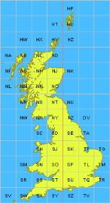
Grid letters
For the first letter, the grid is divided into squares of size 500 km by 500 km, outlined in dark grey on the map to the right. There are four of these which contain significant land area within Great Britain: S, T, N and H. The O square contains a tiny area of North YorkshireNorth Yorkshire
North Yorkshire is a non-metropolitan or shire county located in the Yorkshire and the Humber region of England, and a ceremonial county primarily in that region but partly in North East England. Created in 1974 by the Local Government Act 1972 it covers an area of , making it the largest...
, almost all of which lies below mean high tide.
For the second letter, each 500 km square is subdivided into 25 squares of size 100 km by 100 km, each with a letter code from A to Z (omitting I) starting with A in the north-west corner to Z in the south-east corner. These squares are outlined in light grey on the map, with those containing land lettered. The central (2° W) meridian is shown in red.
It would be possible to extend the grid system over Ireland
Ireland
Ireland is an island to the northwest of continental Europe. It is the third-largest island in Europe and the twentieth-largest island on Earth...
, completing the S and N squares and introducing what would become the R and M squares (with the arrangement of first letters following the same pattern as for the second letter). However, there is no motion for this at the moment, and the accuracy of the projection would start to diminish in the west of Ireland, more than 8 degrees from the central meridian. Theoretically, the system extends far over the Atlantic Ocean
Atlantic Ocean
The Atlantic Ocean is the second-largest of the world's oceanic divisions. With a total area of about , it covers approximately 20% of the Earth's surface and about 26% of its water surface area...
and well into Western Europe
Western Europe
Western Europe is a loose term for the collection of countries in the western most region of the European continents, though this definition is context-dependent and carries cultural and political connotations. One definition describes Western Europe as a geographic entity—the region lying in the...
with square AA near Iceland and square ZZ in northern Italy. In fact, Rockall
Rockall
Rockall is an extremely small, uninhabited, remote rocky islet in the North Atlantic Ocean. It gives its name to one of the sea areas named in the shipping forecast provided by the British Meteorological Office....
is mapped by the Ordnance Survey, but is usually shown as an inset without gridlines on a mainland sheet. However, the grid can be extended to put Rockall in grid square MC as shown in this 1:50,000 mockup.
Grid digits
Within each square, eastings and northings from the origin (south west corner) of the square are given numerically. For example, NH0325 means a 1 km square whose south-west corner is 3 km east and 25 km north from the south-west corner of square NH. A location can be indicated to varying resolutions numerically, usually from two digits in each coordinate (for a 1 km square) through to five (for a 1 m square); in each case the first half of the digits is for the first coordinate and the second half for the other. The most common usage is the six figure grid reference, employing three digits in each coordinate to determine a 100 m square. For example, the grid reference of the 100 m square containing the summit of Ben NevisBen Nevis
Ben Nevis is the highest mountain in the British Isles. It is located at the western end of the Grampian Mountains in the Lochaber area of the Scottish Highlands, close to the town of Fort William....
is . (Grid references may be written with or without spaces, e.g. also NN166712.)
All-numeric grid references
Grid references may also be quoted as a pair of numbers: eastings then northings in metres, measured from the southwest corner of the SV square. Note that 14 digits may be required for locations in Orkney and further north. For example the grid reference for Sullom Voe oil terminalSullom Voe
Sullom Voe is an inlet between North Mainland and Northmavine on Shetland in Scotland. It is a location of the Sullom Voe oil terminal. The word Voe is from the Old Norse vagr and denotes a small bay or narrow creek...
in the Shetland Islands may be given as or .
Another, distinct, form of all-numeric grid reference is an abbreviated alphanumeric reference where the letters are simply omitted, e.g. 166712 for the summit of Ben Nevis. Unlike the numeric references described above, this abbreviated grid reference is incomplete; it gives the location relative to an OS 100×100 km square, but does not specify which square. It is often used informally when the context identifies the OS 2-letter square. For example, within the context of a location known to be on OS Landranger sheet 41 (which extends from NN000500 in the south-west to NN400900 in the north-east) the abbreviated grid reference 166712 is equivalent to NN166712. If working with more than one Landranger sheet, this may also be given as 41/166712.
Alternatively, sometimes numbers instead of the two-letter combinations are used for the 100x100km squares.
The numbering follows a grid index where the tens denote the progress from West to East and the units from South to North. In the north of Scotland, the numbering is modified: the 100 km square to the north of 39 is numbered N30; the square to the north of 49 is N40, etc.
Summary parameters of the coordinate system
- DatumDatumA geodetic datum is a reference from which measurements are made. In surveying and geodesy, a datum is a set of reference points on the Earth's surface against which position measurements are made, and an associated model of the shape of the earth to define a geographic coordinate system...
: OSGB36, - Map projectionMap projectionA map projection is any method of representing the surface of a sphere or other three-dimensional body on a plane. Map projections are necessary for creating maps. All map projections distort the surface in some fashion...
: Transverse Mercator, - True Origin: 49°N49th parallel northThe 49th parallel north is a circle of latitude that is 49 degrees north of the Earth's equatorial plane. It crosses Europe, Asia, the Pacific Ocean, North America, and the Atlantic Ocean....
, 2°W2nd meridian westThe meridian 2° west of Greenwich is a line of longitude that extends from the North Pole across the Arctic Ocean, the Atlantic Ocean, Europe, Africa, the Southern Ocean, and Antarctica to the South Pole.-Geography:...
, - False Origin: 400 km west, 100 km north of True Origin,
- Scale FactorScale factorA scale factor is a number which scales, or multiplies, some quantity. In the equation y=Cx, C is the scale factor for x. C is also the coefficient of x, and may be called the constant of proportionality of y to x...
: 0.9996012717+ - EPSG Code: EPSG:27700
- EllipsoidReference ellipsoidIn geodesy, a reference ellipsoid is a mathematically-defined surface that approximates the geoid, the truer figure of the Earth, or other planetary body....
: Airy 1830 - Semi-major axisSemi-major axisThe major axis of an ellipse is its longest diameter, a line that runs through the centre and both foci, its ends being at the widest points of the shape...
a: 6 377 563.396 m - Semi-minor axisSemi-minor axisIn geometry, the semi-minor axis is a line segment associated with most conic sections . One end of the segment is the center of the conic section, and it is at right angles with the semi-major axis...
b: 6 356 256.909 m - FlatteningFlatteningThe flattening, ellipticity, or oblateness of an oblate spheroid is a measure of the "squashing" of the spheroid's pole, towards its equator...
(derived constant): 1/299.3249646
See also
- World Geodetic SystemWorld Geodetic SystemThe World Geodetic System is a standard for use in cartography, geodesy, and navigation. It comprises a standard coordinate frame for the Earth, a standard spheroidal reference surface for raw altitude data, and a gravitational equipotential surface that defines the nominal sea level.The latest...
- Maps of the UK and IrelandMaps of the UK and IrelandMaps of the UK and Ireland are available in various media.-Maps on CD ROM:ISYS OUTDOORS, Anquet Maps and Fugawi offer a series of 1:25,000, 1:50,000 and 1:250,000 scale UK Ordnance Survey maps including agazetteer of place names...
- Irish grid reference system
- United States National GridUnited States National GridThe United States National Grid is a point reference system of grid references commonly used in United States. It provides a nationally consistent language of location in a user friendly format. It is similar in design to the national grid reference systems used throughout other nations...
- TetradTetrad (unit of area)A tetrad is an area 2 km x 2 km square. The term has a particular use in connection with the British Ordnance Survey national grid, and then refers to any of the 25 such squares which make up a standard hectad....
, HectadHectad (unit of area)A hectad is an area 10 km x 10 km square.The term has a particular use in connection with the British Ordnance Survey national grid, and then refers to any of the 100 such squares which make up a standard 100 km x 100 km myriad; these are denoted using the letter code of the...
, MyriadMyriad (unit of area)A myriad is an area 100 km × 100 km square i.e. it is 10,000 square kilometer. 100 of these squares would be one million square kilometers.... - International Map of the World#Map Indexing System
External links
- Ordnance Survey Guide to the National Grid
- Ordnance Survey Guide to coordinate systems
- Ordnance Survey coordinate transformer
- FieldenMaps.info Co-ordinate Converter - Multiple-format co-ordinate transformer for Great Britain & Channel Islands
- Programs to convert Ordnance Survey grid references
- Open Source Javascript Conversion Library
- GPL Java Conversion Library
- The sole part of Great Britain that lies in the OV square
- JavaScript source code for OS coordinate transforms
- .Net library to convert between lat/lon in various coordinate systems and grid reference
- Libray in the programming language Go to convert from an OSGB36 datum to WGS84 lat/long and vice-versa
- UK Grid Reference Finder. Web utility to find a UK grid reference