

MODIS
Encyclopedia
NASA
The National Aeronautics and Space Administration is the agency of the United States government that is responsible for the nation's civilian space program and for aeronautics and aerospace research...
in 1999 on board the Terra
Terra (satellite)
Terra is a multi-national NASA scientific research satellite in a sun-synchronous orbit around the Earth. It is the flagship of the Earth Observing System...
(EOS
Earth Observing System
The Earth Observing System is a program of NASA comprising a series of artificial satellite missions and scientific instruments in Earth orbit designed for long-term global observations of the land surface, biosphere, atmosphere, and oceans of the Earth. The satellite component of the program was...
AM) Satellite, and in 2002 on board the Aqua
Aqua (satellite)
Aqua is a multi-national NASA scientific research satellite in orbit around the Earth, studying the precipitation, evaporation, and cycling of water. It is the second major component of the Earth Observing System preceded by Terra and followed by Aura .The name "Aqua" comes from the Latin word...
(EOS PM) satellite. The instruments capture data in 36 spectral bands ranging in wavelength from 0.4 µm to 14.4 µm and at varying spatial resolutions (2 bands at 250 m, 5 bands at 500 m and 29 bands at 1 km). Together the instruments image the entire Earth every 1 to 2 days. They are designed to provide measurements in large-scale global dynamics including changes in Earth's cloud cover
Cloud cover
Cloud cover refers to the fraction of the sky obscured by clouds when observed from a particular location...
, radiation budget and processes occurring in the oceans, on land, and in the lower atmosphere. Three on-board calibrators (a solar diffuser combined with a solar diffuser stability monitor, a spectral radiometric calibration assembly, and a blackbody) provide in-flight calibration. MODIS has used the Marine Optical Buoy for vicarious calibration.
The MODIS Characterization Support Team (MCST) is dedicated to the production of high quality MODIS calibrated product which is a precursor to every geophysical science product. A detailed description of the MCST mission statement and other details can be found at MCST Web.
| Specifications | |
|---|---|
| Orbit | 705 km, 10:30 a.m. descending node (Terra) or 1:30 p.m. ascending node (Aqua), sun-synchronous, near-polar, circular |
| Scan Rate | 20.3 rpm, cross track |
| Swath | 2330 km (cross track) by 10 km (along track at nadir) |
| Dimensions | |
| Telescope | 17.78 cm diam. off-axis, afocal Afocal system In optics an afocal system is an optical system that produces no net convergence or divergence of the beam, i.e. has an infinite effective focal length. This type of system can be created with a pair of optical elements where the distance between the elements is equal to the sum of each element's... (collimated), with intermediate field stop |
| Size | 1.0 x 1.6 x 1.0 m |
| Weight | 228.7 kg |
| Power | 162.5 W (single orbit average) |
| Data Rate | 10.6 Mbit/s (peak daytime); 6.1 Mbit/s (orbital average) |
| Quantization | 12 bits |
| Spatial Resolution | 250 m (bands 1-2) 500 m (bands 3-7) 1000 m (bands 8-36) |
| Design Life | 6 years |
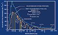
MODIS Bands
| Band | Wavelength Electromagnetic radiation Electromagnetic radiation is a form of energy that exhibits wave-like behavior as it travels through space... (nm Nanometre A nanometre is a unit of length in the metric system, equal to one billionth of a metre. The name combines the SI prefix nano- with the parent unit name metre .The nanometre is often used to express dimensions on the atomic scale: the diameter... ) |
Resolution (m) |
Primary Use |
|---|---|---|---|
| 1 | 620–670 | 250m | Land/Cloud/Aerosols Boundaries |
| 2 | 841–876 | 250m | |
| 3 | 459–479 | 500m | Land/Cloud/Aerosols Properties |
| 4 | 545–565 | 500m | |
| 5 | 1230–1250 | 500m | |
| 6 | 1628–1652 | 500m | |
| 7 | 2105–2155 | 500m | |
| 8 | 405–420 | 1000m | Ocean Color/ Phytoplankton/ Biogeochemistry |
| 9 | 438–448 | 1000m | |
| 10 | 483–493 | 1000m | |
| 11 | 526–536 | 1000m | |
| 12 | 546–556 | 1000m | |
| 13 | 662–672 | 1000m | |
| 14 | 673–683 | 1000m | |
| 15 | 743–753 | 1000m | |
| 16 | 862–877 | 1000m | |
| 17 | 890–920 | 1000m | Atmospheric Water Vapor |
| 18 | 931–941 | 1000m | |
| 19 | 915–965 | 1000m | |
| Band | Wavelength Electromagnetic radiation Electromagnetic radiation is a form of energy that exhibits wave-like behavior as it travels through space... (µm Micrometre A micrometer , is by definition 1×10⁻⁶ of a meter .In plain English, it means one-millionth of a meter . Its unit symbol in the International System of Units is μm... ) |
Resolution (m) |
Primary Use |
| 20 | 3.660–3.840 | 1000m | Surface/Cloud Temperature |
| 21 | 3.929–3.989 | 1000m | |
| 22 | 3.929–3.989 | 1000m | |
| 23 | 4.020–4.080 | 1000m | |
| 24 | 4.433–4.498 | 1000m | Atmospheric Temperature |
| 25 | 4.482–4.549 | 1000m | |
| 26 | 1.360–1.390 | 1000m | Cirrus Clouds Water Vapor |
| 27 | 6.535–6.895 | 1000m | |
| 28 | 7.175–7.475 | 1000m | |
| 29 | 8.400–8.700 | 1000m | Cloud Properties |
| 30 | 9.580–9.880 | 1000m | Ozone |
| 31 | 10.780–11.280 | 1000m | Surface/Cloud Temperature |
| 32 | 11.770–12.270 | 1000m | |
| 33 | 13.185–13.485 | 1000m | Cloud Top Altitude |
| 34 | 13.485–13.785 | 1000m | |
| 35 | 13.785–14.085 | 1000m | |
| 36 | 14.085–14.385 | 1000m | |
MODIS Level 3 datasets
The following MODIS Level 3 (L3) datasets are available from NASA, as processed by the Collection 5 software.| Daily | 8-day | 16-day | 32-day | Monthly | Yearly | Grid | Platform | Description |
|---|---|---|---|---|---|---|---|---|
| MxD08_D3 | MxD08_E3 | — | — | MxD08_M3 | — | 1° CMG | Terra, Aqua | Aerosol, Cloud Water Vapor, Ozone |
| MxD10A1 | MxD10A2 | — | — | — | — | 500 m SIN | Terra, Aqua | Snow Cover |
| MxD11A1 | MxD11A2 | — | — | — | — | 1000 m SIN | Terra, Aqua | Land Surface Temperature/Emissivity |
| MxD11B1 | — | — | — | — | — | 6000 m SIN | Terra, Aqua | Land Surface Temperature/Emissivity |
| MxD11C1 | MxD11C2 | — | — | MxD11C3 | — | 0.05° CMG | Terra, Aqua | Land Surface Temperature/Emissivity |
| — | — | MxD13C1 | — | MxD13C2 | — | 0.05° CMG | Terra, Aqua | Vegetation Indices |
| MxD14A1 | MxD14A2 | — | — | — | — | 1000 m SIN | Terra, Aqua | Thermal Anomalies, Fire |
| — | — | — | — | MCD45A1 | — | 500 m SIN | Terra+Aqua | Burned Area |
| 250 m SIN | 500 m SIN | 1000 m SIN | 0.05° CMG | 1° CMG | Time window | Platform | Description |
|---|---|---|---|---|---|---|---|
| MxD09Q1 | MxD09A1 | — | — | — | 8-day | Terra, Aqua | Surface Reflectance |
| — | — | — | MxD09CMG | — | Daily | Terra, Aqua | Surface Reflectance |
| — | MCD12Q1 | MCD12Q2 | MCD12C1 | — | Yearly | Terra+Aqua | Land Cover Type |
| MxD13Q1 | MxD13A1 | MxD13A2 | MxD13C1 | — | 16-day | Terra, Aqua | Vegetation Indices |
| — | — | MxD13A3 | MxD13C2 | — | Monthly | Terra, Aqua | Vegetation Indices |
| — | MCD43A1 | MCD43B1 | MCD43C1 | — | 16-day | Terra+Aqua | BRDF Bidirectional reflectance distribution function The bidirectional reflectance distribution function is a four-dimensional function that defines how light is reflected at an opaque surface... /Albedo Albedo Albedo , or reflection coefficient, is the diffuse reflectivity or reflecting power of a surface. It is defined as the ratio of reflected radiation from the surface to incident radiation upon it... Model Parameters |
| — | MCD43A3 | MCD43B3 | MCD43C3 | — | 16-day | Terra+Aqua | Albedo |
| — | MCD43A4 | MCD43B4 | MCD43C4 | — | 16-day | Terra+Aqua | Nadir BRDF-Adjusted Reflectance |
Availability
Raw MODIS data stream could be received in real-time using a tracking antenna, thanks to the instrument's direct broadcast capability.Alternatively, the scientific data is made available to the public via several World Wide Web
World Wide Web
The World Wide Web is a system of interlinked hypertext documents accessed via the Internet...
sites and FTP archives, such as:
- ECHO Reverb — the next generation metadata and service discovery tool , intended to replace WIST;
- WIST — Warehouse Inventory Search Tool, scheduled for decomissioning ;
- LAADS Web — Level 1 and Atmosphere Archive and Distribution System (LAADS) web interface;
-
ftp://ladsftp.nascom.nasa.gov/— LAADS underlying FTP server; -
ftp://e4ftl01.cr.usgs.gov/— Earth land surface datasets; -
ftp://n4ftl01u.ecs.nasa.gov/— snow and ice datasets.
Most of the data is available in the HDF-EOS format — a variant of Hierarchical Data Format
Hierarchical Data Format
Hierarchical Data Format is the name of a set of file formats and libraries designed to store and organize large amounts of numerical data...
prescribed for the data derived from Earth Observing System
Earth Observing System
The Earth Observing System is a program of NASA comprising a series of artificial satellite missions and scientific instruments in Earth orbit designed for long-term global observations of the land surface, biosphere, atmosphere, and oceans of the Earth. The satellite component of the program was...
missions.
External links
- Official NASA site
- MODIS bands and spectral ranges (broken link)
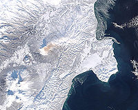
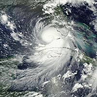
- MODIS Images of the Day
- MODIS Image of the Day - Google Gadget referring to MODIS image of the day.
- Gallery of Images of Interest
- MODIS Land Product Subsetting Tool for North America from Oak Ridge National Laboratory
- MODIS Rapid Response system (near real time images)
- NASA OnEarth (Web service for MODIS imagery)
- Visible Earth: Latest MODIS images
- MODIS Sinusoidal: Projection 6842 - MODIS Sinusoidal
- http://pyevolve.sourceforge.net/wordpress/?p=86Python: accessing near real-time MODIS images and fire data from NASA’s Aqua and Terra satellites (PythonPython (programming language)Python is a general-purpose, high-level programming language whose design philosophy emphasizes code readability. Python claims to "[combine] remarkable power with very clear syntax", and its standard library is large and comprehensive...
)]