
.gif)
Santamaría (volcano)
Encyclopedia
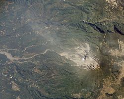
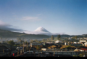
Santa María Volcano is a large active volcano
in the Western Highlands of Guatemala
, close to the city of Quetzaltenango
. Prior to the Spanish Conquest
it was called Gagxanul in the local K'iche' language
. Its eruption in 1902 (VEI
6) was one of the four largest eruptions of the 20th century, after the 1912 Novarupta
and 1991 Pinatubo
eruptions. It is also one of the five biggest eruptions of the past 200 (and probably 300) years.
 Santa María is part of the Sierra Madre
range of volcanoes, which extends along the western edge of Guatemala
, separated from the Pacific Ocean
by a broad plain. The volcanoes are formed by the subduction
of the Cocos Plate
under the Caribbean Plate
, which led to the formation of the Central America Volcanic Arc.
Eruptions at Santa María are estimated to have begun about 30,000 years ago. For several thousand years, eruptions seem to have been small and frequent, building up the large cone of the volcano, reaching about 1400 metres (4,593.2 ft) above the plain on which the nearby city of Quetzaltenango
sits. Following the cone-building eruptions, activity seems to have changed to a pattern of long periods of repose followed by the emission of small lava flows from vents on the flanks.
The cone built by the eruptions had a volume of about 10 cubic kilometres (2.4 cu mi), and consisted of a mixture of basalt
and andesite
lavas.
 The first eruption of Santa María in the recorded history occurred in October 1902. Before 1902 the volcano had been dormant for at least 500 years and possibly several thousand years, but its awakening was clearly indicated by a seismic swarm
in the region starting in January 1902, which included a major earthquake in April 1902. The eruption began on 24 October, and the largest explosions occurred over the following two days, ejecting an estimated 5.5 cubic kilometres (1.3 cu mi) of magma
. The eruption was one of the largest of the 20th century, only slightly less in magnitude to that of Mount Pinatubo
in 1991. The eruption had a VEI
of 6, thus being 'Colossal'.
The pumice
formed in the climactic eruption fell over an area of about 273000 square kilometres (105,405.9 sq mi), and volcanic ash
was detected as far away as San Francisco, 4000 kilometres (2,485.5 mi) away. The eruption tore away much of the south-western flank of the volcano, leaving a crater about 1 kilometre (0.621372736649807 mi) in diameter and about 300 metres (984.3 ft) deep, stretching from just below the summit to an elevation of about 2300 metres (7,545.9 ft).
Because of the lack of previous Holocene
activity at Santa María, local people did not recognise the preceding seismicity as warning signs of an eruption. At least 5,000 people died as a result of the eruption itself, and a subsequent outbreak of malaria
killed many more.
in the crater left by the 1902 eruption. The lava dome was dacitic
in composition
. The dome was christened Santiaguito, and since then, activity has been virtually constant. Santiaguito now reaches a height of about 2500 metres (8,202.1 ft), and has a volume of about 1 cubic kilometre (0.239912758604287 cu mi). From the summit of Santa María, it is possible to look down on the eruptions at Santiaguito a mile below.
Dome growth at Santiaguito has alternated between growth caused by the emission of lava flows, and inflation caused by the injection of magma into the middle of the dome. These dome growth types are described by volcanologists as exogenous and endogenous respectively. Activity has been concentrated at several different vents, and Santiaguito now has the appearance of several overlapping domes. The currently active vent is El Caliente. There are three other domes - El Brujo, El Mitad and El Monje.
Although most of Santiaguito's eruptive activity has been relatively gentle, occasional larger explosions have occurred. In 1929, part of the dome collapsed, generating pyroclastic flow
s which killed anywhere from several hundred up to 5,000 people. Occasional rockfalls have generated smaller pyroclastic flows, and vertical eruptions of ash to heights of a few kilometres above the dome are common.
s, which frequently occur in the rainy season due to heavy rainfall on loose volcanic deposits. The town of El Palmar
, 10 kilometres (6.2 mi) from Santiaguito, has been destroyed twice by lahars from Santiaguito forcing the town to be moved to the present Nuevo El Palmar, and infrastructure
such as roads and bridges have been repeatedly damaged. Lahar deposits from Santiaguito have affected rivers all the way downstream to the Pacific Ocean.
 Lava flows do not occur frequently from Santiaguito, and tend to stretch no more than a few kilometres from the dome. The magma at Santiaguito is rich in silica and is thus highly viscous
. Lava flows are therefore slow-moving and are of little danger to human life, although property damage may occur. Fast-moving pyroclastic flows can occur, and these may travel several kilometres from the dome.
One hazard which could be devastating is the collapse of Santa María itself. The 1902 crater has left the southern flank of the mountain above Santiaguito highly over-steepened, and a large earthquake
or eruption from Santiaguito could trigger a huge landslide
, which might cover up to 100 square kilometres (38.6 sq mi). However, this is thought to be unlikely in the short term.
In light of the threat it poses to nearby populations, Santa María has been designated a Decade Volcano, identifying it as a target for particular study by volcanologists to mitigate any future natural disasters at the volcano.
Volcano
2. Bedrock3. Conduit 4. Base5. Sill6. Dike7. Layers of ash emitted by the volcano8. Flank| 9. Layers of lava emitted by the volcano10. Throat11. Parasitic cone12. Lava flow13. Vent14. Crater15...
in the Western Highlands of Guatemala
Guatemala
Guatemala is a country in Central America bordered by Mexico to the north and west, the Pacific Ocean to the southwest, Belize to the northeast, the Caribbean to the east, and Honduras and El Salvador to the southeast...
, close to the city of Quetzaltenango
Quetzaltenango
Quetzaltenango, also commonly known by its indigenous name, Xelajú , or more commonly, Xela , is the second largest city of Guatemala. It is both the capital of Quetzaltenango Department and the municipal seat of Quetzaltenango municipality....
. Prior to the Spanish Conquest
Spanish colonization of the Americas
Colonial expansion under the Spanish Empire was initiated by the Spanish conquistadores and developed by the Monarchy of Spain through its administrators and missionaries. The motivations for colonial expansion were trade and the spread of the Christian faith through indigenous conversions...
it was called Gagxanul in the local K'iche' language
K'iche' language
The K’iche’ language is a part of the Mayan language family. It is spoken by many K'iche' people in the central highlands of Guatemala. With close to a million speakers , it is the second-most widely spoken language in the country after Spanish...
. Its eruption in 1902 (VEI
Volcanic Explosivity Index
The Volcanic Explosivity Index was devised by Chris Newhall of the U.S. Geological Survey and Stephen Self at the University of Hawaii in 1982 to provide a relative measure of the explosiveness of volcanic eruptions....
6) was one of the four largest eruptions of the 20th century, after the 1912 Novarupta
Novarupta
Novarupta, meaning "new eruption", is a volcano located on the Alaska Peninsula in Katmai National Park and Preserve, about southwest of Anchorage. Formed in 1912 during the largest volcanic eruption of the 20th century, Novarupta released 30 times the volume of magma as the 1980 eruption of...
and 1991 Pinatubo
Mount Pinatubo
Mount Pinatubo is an active stratovolcano located on the island of Luzon, near the tripoint of the Philippine provinces of Zambales, Tarlac, and Pampanga. It is located in the Tri-Cabusilan Mountain range separating the west coast of Luzon from the central plains, and is west of the dormant and...
eruptions. It is also one of the five biggest eruptions of the past 200 (and probably 300) years.
Geological history
Sierra Madre de Chiapas
Sierra Madre is a mountain range which runs northwest-southeast from the state of Chiapas in Mexico across Guatemala and into El Salvador and Honduras. Most of the volcanoes of Guatemala are a part of this range.A narrow coastal plain lies south the range, between the Sierra Madre and the Pacific...
range of volcanoes, which extends along the western edge of Guatemala
Guatemala
Guatemala is a country in Central America bordered by Mexico to the north and west, the Pacific Ocean to the southwest, Belize to the northeast, the Caribbean to the east, and Honduras and El Salvador to the southeast...
, separated from the Pacific Ocean
Pacific Ocean
The Pacific Ocean is the largest of the Earth's oceanic divisions. It extends from the Arctic in the north to the Southern Ocean in the south, bounded by Asia and Australia in the west, and the Americas in the east.At 165.2 million square kilometres in area, this largest division of the World...
by a broad plain. The volcanoes are formed by the subduction
Subduction
In geology, subduction is the process that takes place at convergent boundaries by which one tectonic plate moves under another tectonic plate, sinking into the Earth's mantle, as the plates converge. These 3D regions of mantle downwellings are known as "Subduction Zones"...
of the Cocos Plate
Cocos Plate
The Cocos Plate is an oceanic tectonic plate beneath the Pacific Ocean off the west coast of Central America, named for Cocos Island, which rides upon it.-Geology:...
under the Caribbean Plate
Caribbean Plate
The Caribbean Plate is a mostly oceanic tectonic plate underlying Central America and the Caribbean Sea off the north coast of South America....
, which led to the formation of the Central America Volcanic Arc.
Eruptions at Santa María are estimated to have begun about 30,000 years ago. For several thousand years, eruptions seem to have been small and frequent, building up the large cone of the volcano, reaching about 1400 metres (4,593.2 ft) above the plain on which the nearby city of Quetzaltenango
Quetzaltenango
Quetzaltenango, also commonly known by its indigenous name, Xelajú , or more commonly, Xela , is the second largest city of Guatemala. It is both the capital of Quetzaltenango Department and the municipal seat of Quetzaltenango municipality....
sits. Following the cone-building eruptions, activity seems to have changed to a pattern of long periods of repose followed by the emission of small lava flows from vents on the flanks.
The cone built by the eruptions had a volume of about 10 cubic kilometres (2.4 cu mi), and consisted of a mixture of basalt
Basalt
Basalt is a common extrusive volcanic rock. It is usually grey to black and fine-grained due to rapid cooling of lava at the surface of a planet. It may be porphyritic containing larger crystals in a fine matrix, or vesicular, or frothy scoria. Unweathered basalt is black or grey...
and andesite
Andesite
Andesite is an extrusive igneous, volcanic rock, of intermediate composition, with aphanitic to porphyritic texture. In a general sense, it is the intermediate type between basalt and dacite. The mineral assemblage is typically dominated by plagioclase plus pyroxene and/or hornblende. Magnetite,...
lavas.
1902 eruption
Earthquake swarm
Earthquake swarms are events where a local area experiences sequences of many earthquakes striking in a relatively short period of time. The length of time used to define the swarm itself varies, but the United States Geological Survey points out that an event may be on the order of days, weeks, or...
in the region starting in January 1902, which included a major earthquake in April 1902. The eruption began on 24 October, and the largest explosions occurred over the following two days, ejecting an estimated 5.5 cubic kilometres (1.3 cu mi) of magma
Magma
Magma is a mixture of molten rock, volatiles and solids that is found beneath the surface of the Earth, and is expected to exist on other terrestrial planets. Besides molten rock, magma may also contain suspended crystals and dissolved gas and sometimes also gas bubbles. Magma often collects in...
. The eruption was one of the largest of the 20th century, only slightly less in magnitude to that of Mount Pinatubo
Mount Pinatubo
Mount Pinatubo is an active stratovolcano located on the island of Luzon, near the tripoint of the Philippine provinces of Zambales, Tarlac, and Pampanga. It is located in the Tri-Cabusilan Mountain range separating the west coast of Luzon from the central plains, and is west of the dormant and...
in 1991. The eruption had a VEI
Volcanic Explosivity Index
The Volcanic Explosivity Index was devised by Chris Newhall of the U.S. Geological Survey and Stephen Self at the University of Hawaii in 1982 to provide a relative measure of the explosiveness of volcanic eruptions....
of 6, thus being 'Colossal'.
The pumice
Pumice
Pumice is a textural term for a volcanic rock that is a solidified frothy lava typically created when super-heated, highly pressurized rock is violently ejected from a volcano. It can be formed when lava and water are mixed. This unusual formation is due to the simultaneous actions of rapid...
formed in the climactic eruption fell over an area of about 273000 square kilometres (105,405.9 sq mi), and volcanic ash
Volcanic ash
Volcanic ash consists of small tephra, which are bits of pulverized rock and glass created by volcanic eruptions, less than in diameter. There are three mechanisms of volcanic ash formation: gas release under decompression causing magmatic eruptions; thermal contraction from chilling on contact...
was detected as far away as San Francisco, 4000 kilometres (2,485.5 mi) away. The eruption tore away much of the south-western flank of the volcano, leaving a crater about 1 kilometre (0.621372736649807 mi) in diameter and about 300 metres (984.3 ft) deep, stretching from just below the summit to an elevation of about 2300 metres (7,545.9 ft).
Because of the lack of previous Holocene
Holocene
The Holocene is a geological epoch which began at the end of the Pleistocene and continues to the present. The Holocene is part of the Quaternary period. Its name comes from the Greek words and , meaning "entirely recent"...
activity at Santa María, local people did not recognise the preceding seismicity as warning signs of an eruption. At least 5,000 people died as a result of the eruption itself, and a subsequent outbreak of malaria
Malaria
Malaria is a mosquito-borne infectious disease of humans and other animals caused by eukaryotic protists of the genus Plasmodium. The disease results from the multiplication of Plasmodium parasites within red blood cells, causing symptoms that typically include fever and headache, in severe cases...
killed many more.
Santiaguito
The 1902 eruption was followed by 20 years of dormancy. In 1922, new eruptions began, with the extrusion of a lava domeLava dome
|250px|thumb|right|Image of the [[rhyolitic]] lava dome of [[Chaitén Volcano]] during its 2008–2009 eruption.In volcanology, a lava dome is a roughly circular mound-shaped protrusion resulting from the slow extrusion of viscous lava from a volcano...
in the crater left by the 1902 eruption. The lava dome was dacitic
Dacite
Dacite is an igneous, volcanic rock. It has an aphanitic to porphyritic texture and is intermediate in composition between andesite and rhyolite. The relative proportions of feldspars and quartz in dacite, and in many other volcanic rocks, are illustrated in the QAPF diagram...
in composition
. The dome was christened Santiaguito, and since then, activity has been virtually constant. Santiaguito now reaches a height of about 2500 metres (8,202.1 ft), and has a volume of about 1 cubic kilometre (0.239912758604287 cu mi). From the summit of Santa María, it is possible to look down on the eruptions at Santiaguito a mile below.
Dome growth at Santiaguito has alternated between growth caused by the emission of lava flows, and inflation caused by the injection of magma into the middle of the dome. These dome growth types are described by volcanologists as exogenous and endogenous respectively. Activity has been concentrated at several different vents, and Santiaguito now has the appearance of several overlapping domes. The currently active vent is El Caliente. There are three other domes - El Brujo, El Mitad and El Monje.
Although most of Santiaguito's eruptive activity has been relatively gentle, occasional larger explosions have occurred. In 1929, part of the dome collapsed, generating pyroclastic flow
Pyroclastic flow
A pyroclastic flow is a fast-moving current of superheated gas and rock , which reaches speeds moving away from a volcano of up to 700 km/h . The flows normally hug the ground and travel downhill, or spread laterally under gravity...
s which killed anywhere from several hundred up to 5,000 people. Occasional rockfalls have generated smaller pyroclastic flows, and vertical eruptions of ash to heights of a few kilometres above the dome are common.
Volcanic hazards at Santa María
The areas to the south of Santa María are considerably affected by volcanic activity at Santiaguito. Currently, the most common volcanic hazards at Santa María are laharLahar
A lahar is a type of mudflow or debris flow composed of a slurry of pyroclastic material, rocky debris, and water. The material flows down from a volcano, typically along a river valley. The term is a shortened version of "berlahar" which originated in the Javanese language of...
s, which frequently occur in the rainy season due to heavy rainfall on loose volcanic deposits. The town of El Palmar
El Palmar, Quetzaltenango
El Palmar is a municipality in the Quetzaltenango department of GuatemalaEl Palmar is mostly an agricultural municipality, with coffee being one of its main products....
, 10 kilometres (6.2 mi) from Santiaguito, has been destroyed twice by lahars from Santiaguito forcing the town to be moved to the present Nuevo El Palmar, and infrastructure
Infrastructure
Infrastructure is basic physical and organizational structures needed for the operation of a society or enterprise, or the services and facilities necessary for an economy to function...
such as roads and bridges have been repeatedly damaged. Lahar deposits from Santiaguito have affected rivers all the way downstream to the Pacific Ocean.
Viscosity
Viscosity is a measure of the resistance of a fluid which is being deformed by either shear or tensile stress. In everyday terms , viscosity is "thickness" or "internal friction". Thus, water is "thin", having a lower viscosity, while honey is "thick", having a higher viscosity...
. Lava flows are therefore slow-moving and are of little danger to human life, although property damage may occur. Fast-moving pyroclastic flows can occur, and these may travel several kilometres from the dome.
One hazard which could be devastating is the collapse of Santa María itself. The 1902 crater has left the southern flank of the mountain above Santiaguito highly over-steepened, and a large earthquake
Earthquake
An earthquake is the result of a sudden release of energy in the Earth's crust that creates seismic waves. The seismicity, seismism or seismic activity of an area refers to the frequency, type and size of earthquakes experienced over a period of time...
or eruption from Santiaguito could trigger a huge landslide
Landslide
A landslide or landslip is a geological phenomenon which includes a wide range of ground movement, such as rockfalls, deep failure of slopes and shallow debris flows, which can occur in offshore, coastal and onshore environments...
, which might cover up to 100 square kilometres (38.6 sq mi). However, this is thought to be unlikely in the short term.
In light of the threat it poses to nearby populations, Santa María has been designated a Decade Volcano, identifying it as a target for particular study by volcanologists to mitigate any future natural disasters at the volcano.
See also
- List of volcanoes in Guatemala
- List of volcanic eruptions by death toll
- Timetable of major worldwide volcanic eruptionsTimetable of major worldwide volcanic eruptionsThis article is a list of volcanic eruptions of approximately at least magnitude 6 on the Volcanic Explosivity Index or equivalent sulfur dioxide emission around the Quaternary period. Some cooled the global climate; the extent of this effect depends on the amount of sulfur dioxide emitted...