

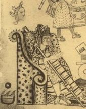
San Miguel Ixtapan (archaeological site)
Encyclopedia
| Otomi Culture – Archaeological Site | ||
| Name: | San Miguel Ixtapan Archaeological Site | |
| Type | Mesoamerican archaeology | |
| Location | San Miguel Ixtapan, Tejupilco (municipality) Tejupilco (municipality) Tejupilco is municipality in the State of Mexico, Mexico, located approximately 100 kilometres southwest of the state capital Toluca, along Federal Highway 34. Its municipal seat is Tejupilco de Hidalgo... , State of Mexico |
|
| Region | Mesoamerica Mesoamerica Mesoamerica is a region and culture area in the Americas, extending approximately from central Mexico to Belize, Guatemala, El Salvador, Honduras, Nicaragua, and Costa Rica, within which a number of pre-Columbian societies flourished before the Spanish colonization of the Americas in the 15th and... |
|
| Coordinates | 18°48′27"N 100°09′19"W | |
| Culture | Otomí Otomi people The Otomi people . Smaller Otomi populations exist in the states of Puebla, Mexico, Tlaxcala, Michoacán and Guanajuato. The Otomi language belonging to the Oto-Pamean branch of the Oto-Manguean language family is spoken in many different varieties some of which are not mutually intelligible.One of... – Toltec Toltec The Toltec culture is an archaeological Mesoamerican culture that dominated a state centered in Tula, Hidalgo in the early post-classic period of Mesoamerican chronology... – Aztec Aztec The Aztec people were certain ethnic groups of central Mexico, particularly those groups who spoke the Nahuatl language and who dominated large parts of Mesoamerica in the 14th, 15th and 16th centuries, a period referred to as the late post-classic period in Mesoamerican chronology.Aztec is the... |
|
| Language | Otomí Otomi language Otomi is an Oto-Manguean language and one of the indigenous languages of Mexico, spoken by approximately 240,000 indigenous Otomi people in the central altiplano region of Mexico. The language is spoken in many different dialects, some of which are not mutually intelligible, therefore it is in... – Nahuatl Nahuatl Nahuatl is thought to mean "a good, clear sound" This language name has several spellings, among them náhuatl , Naoatl, Nauatl, Nahuatl, Nawatl. In a back formation from the name of the language, the ethnic group of Nahuatl speakers are called Nahua... |
|
| Chronology | 500 to 1500 CE | |
| Period | Mesoamerican Classical, Postclassical | |
| Apogee | 750 to 900 CE | |
| INAH Web Page | San Miguel Ixtapan Archaeological Site | |
San Miguel Ixtapan is an archaeological site located in the municipality of Tejupilco (Nahuatl
Nahuatl
Nahuatl is thought to mean "a good, clear sound" This language name has several spellings, among them náhuatl , Naoatl, Nauatl, Nahuatl, Nawatl. In a back formation from the name of the language, the ethnic group of Nahuatl speakers are called Nahua...
"Texopilco" or “Texopilli”), in the State of Mexico.
Tejupilco is about 100 kilometers west from the city of Toluca, Mexico State, on federal highway 134. The site is some 15 kilometers south of the municipal head, on state highway 8 that leads to Amatepec.
This site is one of the few explored in the southwest region of the State of Mexico, that has provided some archaeological information on an area that virtually was not explored.
Its apogee was in the aftermath of the Teotihuacan decline. Located in an area which probably served as a liaison between the Central Highlands and regions of Michoacán and Guerrero, San Miguel Ixtapan had its greatest growth between 750 and 900 CE. Then the site reaches a substantial expansion and built most of the structures of the ceremonial area now visible, they represent only a portion of what was the site in its splendor. San Miguel Ixtapan was located in a privileged place with deposits of basalt prisms used for construction, fertile land and one of the larger flow springs in the State.
Background
The earliest evidence of human habitation in the state is a quartzQuartz
Quartz is the second-most-abundant mineral in the Earth's continental crust, after feldspar. It is made up of a continuous framework of SiO4 silicon–oxygen tetrahedra, with each oxygen being shared between two tetrahedra, giving an overall formula SiO2. There are many different varieties of quartz,...
scraper and obsidian
Obsidian
Obsidian is a naturally occurring volcanic glass formed as an extrusive igneous rock.It is produced when felsic lava extruded from a volcano cools rapidly with minimum crystal growth...
blade found in the Tlapacoya area
Tlapacoya (Mesoamerican site)
Tlapacoya is an important archaeological site in Mexico, located at the foot of the Tlapacoya volcano, southeast of Mexico City, on the former shore of Lake Chalco. Tlapacoya was a major site for the Tlatilco culture....
, which was an island in the former Lake Chalco
Lake Chalco
Lake Chalco was an endorheic lake formerly located in the Valley of Mexico and was important for human development in central Mexico. The lake was named after the city of Chalco on its eastern shore....
. They are dated to the Pleistocene
Pleistocene
The Pleistocene is the epoch from 2,588,000 to 11,700 years BP that spans the world's recent period of repeated glaciations. The name pleistocene is derived from the Greek and ....
era which dates human habitation back to 20,000 years. These first peoples were hunter-gatherers. Stone Age implements have been found all over the territory from mammoth bones, to stone tools to human remains. Most have been found in the areas of Los Reyes Acozac
Los Reyes Acozac
Los Reyes Acozac is a community that belongs to the municipality of Tecámac in the State of Mexico in Mexico. It has a population of 20,478 inhabitants and is located at an altitude of 2,250 meters above sea level. The area is known for significant deposits of mammoth bones.-References:...
, Tizayuca
Tizayuca
Tizayuca is a town and one of the 84 municipalities of Hidalgo, in central-eastern Mexico. The municipality covers an area of 92.5 km².As of 2005, the municipality had a total population of 56,573....
, Tepexpan
Tepexpan
Tepexpan is the largest town in the Acolman municipality in Mexico State, Mexico. The population was 48,103 as of the 2005 Mexican census.One of the most interesting aspects of this town is the discovery of an early Mesoamerican skeleton commonly referred to as "Tepexpan man". Recent research tries...
, San Francisco Mazapa, El Risco and Tequixquiac
Tequixquiac
Santiago Tequixquiac is the seat of the municipality of Tequixquiac located in the northeastern part of the state of Mexico in Mexico, although both are commonly called Tequixquiac. The town is located at a northern pass leading out of the Valley of Mexico and about 120 km northeast of the...
. Between 20,000 and 5000 BCE, the people here eventually went from hunting and gathering to sedimentary villages with farming and domesticated animals. The main crop was corn, and stone tools for the grinding of this grain become common. Later crops include beans, chili peppers and squash grown near established villages. Evidence of ceramics appears around 2500 BCE with the earliest artifacts of these appearing in Tlapacoya, Atoto
Atoto
Atoto is a village in Ancuabe District in Cabo Delgado Province in northeastern Mozambique.-External links:*...
, Malinalco
Malinalco
Malinalco is a town and municipality located 65 kilometers south of the city of Toluca in the south of the western portion of the Mexico State. Malinalco is 115 km southwest Mexico City....
, Acatzingo and Tlatilco
Tlatilco
Tlatilco was a large pre-Columbian village in the Valley of Mexico situated near the modern-day town of the same name in the Mexican Federal District. It was one of the first chiefdom centers to arise in the Valley, flourishing on the western shore of Lake Texcoco during the Middle Pre-Classic...
.
The earliest major city of the state is Teotihuacan
Teotihuacan
Teotihuacan – also written Teotihuacán, with a Spanish orthographic accent on the last syllable – is an enormous archaeological site in the Basin of Mexico, just 30 miles northeast of Mexico City, containing some of the largest pyramidal structures built in the pre-Columbian Americas...
, built between 100 BCE and 100 CE.
Between 800 and 900 CE, the Matlatzinca
Matlatzinca
Matlatzinca is a name used to refer to different indigenous ethnic groups in the Toluca Valley in the state of México, located in the central highlands of Mexico. The term is applied to the ethnic group inhabiting the valley of Toluca and to their language, Matlatzinca.When used as an ethnonym,...
s established their dominion with Teotenango
Teotenango
Teotenango was in important pre-Hispanic fortified city located in the southern part of the Valley of Toluca. It was initially founded during the last stages of the Teotihuacan civilization by a group generally referred to as the “Teotenancas.” Later, the Matlatzincas conquered the city and...
as capital.
Axayacatl
Axayacatl was the sixth Aztec Emperor, a ruler of the Postclassic Mesoamerican Aztec Empire and city of Tenochtitlan, who reigned from 1469 to 1481.He is chiefly remembered for subjugating Tlatelolco, Tenochtitlan's sister city, in 1473....
reign (1469–1481) the Aztecs and tarascan conquered much of the matlazincas settlements, imposing names such as: Metepec, Capulhuac Quauhpanoayan, Xochiaca Tzinacantepec, Zoquitzinco, Toluca, Xiquipilco, Tenantzinco, Teotenango and Calixtlahuaca.
Other dominions during the prehispanic period include that of the Chichimeca
Chichimeca
Chichimeca was the name that the Nahua peoples of Mexico generically applied to a wide range of semi-nomadic peoples who inhabited the north of modern-day Mexico and southwestern United States, and carried the same sense as the European term "barbarian"...
s in Tenayuca
Tenayuca
Tenayuca is a pre-Columbian Mesoamerican archaeological site in the Valley of Mexico. In the Postclassic period of Mesoamerican chronology Tenayuca was a settlement on the former shoreline of the western arm of Lake Texcoco, located approximately 10km to the northwest of Tenochtitlan...
and of the Acolhua
Acolhua
The Acolhua are a Mesoamerican people who arrived in the Valley of Mexico in or around the year 1200 CE. The Acolhua were a sister culture of the Aztecs as well as the Tepanec, Chalca, Xochimilca and others....
s in Huexotla
Texcoco, Mexico State
Texcoco is a city and municipality located in the northeast portion of Mexico State, 25 km northeast of Mexico City. In the pre-Hispanic era, this was a major Aztec city on the shores of Lake Texcoco. After the Conquest, the city was initially the second most important after Mexico City,...
, Texcotizingo and Los Melones. Other important groups were the Mazahua
Mazahua
The Mazahua are an indigenous people of Mexico, inhabiting the northwestern portion of the State of Mexico and northeastern area of Michoacán, with a presence also in the Federal District owing to recent migration...
s in the Atlacomulco
Atlacomulco
Atlacomulco is a city and municipality located in the northwest of the State of Mexico in central Mexico, 63 km from the state capital of Toluca. The name is derived from the Nahuatl phrase "atlacomulli" which means "where there are wells." The city, with a population of 20,477 is...
area. Their center was at Mazahuacán, next to Jocotitlán
Jocotitlán
Jocotitlán is a town and municipality located in the northwestern part of the State of Mexico on the central highlands of the country of Mexico. The town is located at the foot of the Jocotitlán or Xocotépetl volcano, while most of the rest of the municipality is in the Ixtlahuaca Valley...
mountain. The Otomi
Otomi people
The Otomi people . Smaller Otomi populations exist in the states of Puebla, Mexico, Tlaxcala, Michoacán and Guanajuato. The Otomi language belonging to the Oto-Pamean branch of the Oto-Manguean language family is spoken in many different varieties some of which are not mutually intelligible.One of...
s were centered in Jilotepec.
Toponymy
The name of the place is composed from the words “Iztatl” (salt) and “pan” (place): “place where is salt”, this makes reference to the importance that salt exploitation had from prehispanic times, it was fundamentally due to the saltpeter (Potassium nitratePotassium nitrate
Potassium nitrate is a chemical compound with the formula KNO3. It is an ionic salt of potassium ions K+ and nitrate ions NO3−.It occurs as a mineral niter and is a natural solid source of nitrogen. Its common names include saltpetre , from medieval Latin sal petræ: "stone salt" or possibly "Salt...
) water wells that existed near the town. (Still mined, although in smaller scale)
In relation to Tejupilco, there is no certainty of the true meaning of the word Tejupilco until today, it is known that a large volcanic rock which has a human footprint in the Huarache Hill east of San Simón, gave name to the place.
Texopilco, as it was known to the arrival of the Spaniards and several decades afterwards, has had several versions of its meaning: Texo (foot print), pilli (small), place of small footprint, Te (not own), xopilli (toes). Place of strange footprints, or Tetl (stone), xo (foot), pilli (son or prince) Place of important people footprints.
Interpretations have changed through the centuries, according to knowledge, feelings, views and opinions of the authors.
Investigations
Initial explorations of this site occurred in 1985, it focused on the model found. The site was discovered by farmers plowing the land, when rocks and other vestiges were detected.It is difficult to determine the site constructors, although filiation from ethno historical sources indicates they were closely related to the Otomi
Otomi people
The Otomi people . Smaller Otomi populations exist in the states of Puebla, Mexico, Tlaxcala, Michoacán and Guanajuato. The Otomi language belonging to the Oto-Pamean branch of the Oto-Manguean language family is spoken in many different varieties some of which are not mutually intelligible.One of...
culture.
The first report of the site was given in 1958, upon discovering the so-called "model", a basaltic stone where the city was carved in miniature. The stone is now under roof, under a shelter next to the Museum. It was initially thought that it was a representation of the archaeological site; however, subsequent excavations demonstrated that it is not the case and so far not found a site that matches its design; now it is considered an ideal representation of a city or a sculpted ceremonial center sculpted, taking advantage of the rock morphology.
Occupations
As a result of site field investigations, at least four occupation stages were detected.- First Occupation. Corresponds to the last years of the Classical period (500 to 750 CE), it includes remains of a housing residential structure where Teotihuacan III and IV type figurines were discovered.
- Second occupation. Is chronologically placed during the epiclassical period (750 to 900 CE), considered the apogee of the site, when the main structures of the place are constructed.
- Third occupation. It is placed during the early postclassical (900 to 1200 CE), the main monuments are reused, with several architectonic modifications, additions and extensions.
- Fourth Occupation. After 1200 CE, the site is abandoned for some time, until the time when the site is partially reoccupied by a cultural group part of the Mexica or Aztec culture; they built simple houses over the remains of older structures and remained on the site until the time Spanish invasion. One of the possible reasons why the Aztecs arrived to the area is that it is located on a strategic location, for trade control of goods from Tierra Caliente towards the central Highlands and vice versa. In addition to the saltpeter wells, previously mentioned, a product highly appreciated in prehispanic times.
12000 BCE
The oldest evidence of human occupation of these lands dates back to more than 12 thousand years, approximate date when Tejupilco cave paintings were. Early hunter-gatherers who arrived in the region at the end of the third glaciation evolved to become sedentary groups of farmers, complex societies and cultures which formed part of other civilizations.The plentiful natural resources, consequence of the rugged geography formed from millions of years ago, attracted to the Tejupilco region early settlers at least 10 thousand years ago, date in which hunter-gatherer groups created the cave paintings at the “Cueva de los Monitos”; located north of “Bejucos” at the foot of the Nanchititla Sierra. The hunter-gatherer groups have evolved to sedentary tribes through peaceful or violent exchanges with other cultures, to the domain of agriculture and domestication of animals, basic astronomical, medical and scientific knowledge.
These settlements scattered throughout the region evolved, some to become complex cultures with language and religion, stratified societies and priestly classes. Others collapsed and were forgotten until the recent discovery of its ruins and study of remains that repositioned them as key parts for the study and understanding of regional history.
2000 BCE
The most remote archaeological discovery is located in the archaeological area of San Miguel Ixtapan, atop of a pyramid basement, still unexplored; a mask and jade necklace were found alongside organic remains. These artifacts belong to an unknown culture that flourished in San Miguel Ixtapan, but over two thousand years before the site recorded history.Sites such as “Río Grande” and the “Pararrayos de San Miguel”, evidenced the collapse of the settlement from hundreds or thousands of years before the conquest of Mexico. In San Miguel Ixtapan a human body was discovered, while digging to install a lightning rod, along with prepared foods, on top of a pyramid-like basement. The body provided a chronological placement to 2000 years BCE, which means that a culture existed about 4 thousand years ago, which probably collapsed due to an invasion, next to the body finding, a necklace and green stone mask were found, these are exhibited in the San Miguel Ixtapan site Museum. In the same site are located the San Miguel Ixtapan ruins, a much later culture.
450 CE
San Miguel Ixtapan, only archaeological site moderately excavated and studied, of the more than 180 sites existing in the region. The San Miguel Ixtapan culture flourished from 450 to 1522 CE, possibly the Chontal culture from the Balsas with close cultural and commercial ties with Teotihuacan, Tula, and the Central Highlands as well as other points of Tierra Caliente.The complex cultural overlay present in Mesoamerica throughout centuries, also existed in Tejupilco, where eventually a Chontal Kingdom was formed (Chontal meaning foreigner or not Aztec) probably Matlazinca with Tejupilco as capital and composed, according to Gaspar de Covarrubias by 18 groups
1475 CE
The Aztecs conquered the Tejupilco kingdom.Tejupilco was conquered by the Mexicas or Aztecs around 1475-1476, during the reign of Axayacatl, consequently, at the time of the conquest the Matlazinca and Nahuatl or Mexican was spoken in the region
Otomi Culture
Indigenous peoples of Mexico
Mexico, in the second article of its Constitution, is defined as a "pluricultural" nation in recognition of the diverse ethnic groups that constitute it, and in which the indigenous peoples are the original foundation...
inhabiting the central altiplano of Mexico
Mexico
The United Mexican States , commonly known as Mexico , is a federal constitutional republic in North America. It is bordered on the north by the United States; on the south and west by the Pacific Ocean; on the southeast by Guatemala, Belize, and the Caribbean Sea; and on the east by the Gulf of...
. The two most populous groups are the Highland or Sierra Otomí living in the mountains of La Huasteca
La Huasteca
La Huasteca is the first climbing area in Monterrey, Mexico, only 15 minutes from the city. With nearly 200 bolted routes with grades from 5.8 to 5.13C, it is the favorite place for weekend climbers. It is also known for the slippery type of limestone from which it is comprised, and which makes...
and the Mezquital Otomí, living in the Mezquital valley in the eastern part of the state of Hidalgo, and in the Sierra of Querétaro state. The Otomí usually self-identify as Ñuhu or Ñuhmu depending on the dialect they speak, whereas Mezquital Otomi identify themselves as Hñähñu . Smaller Otomi populations exist in the states of Puebla
Puebla
Puebla officially Estado Libre y Soberano de Puebla is one of the 31 states which, with the Federal District, comprise the 32 Federal Entities of Mexico. It is divided in 217 municipalities and its capital city is Puebla....
, Mexico
Mexico (state)
México , officially: Estado Libre y Soberano de México is one of the 31 states which, with the Federal District, comprise the 32 Federal Entities of the United Mexican States. It is divided in 125 municipalities and its capital city is Toluca de Lerdo....
, Tlaxcala
Tlaxcala
Tlaxcala officially Estado Libre y Soberano de Tlaxcala is one of the 31 states which along with the Federal District comprise the 32 federative entities of Mexico. It is divided into 60 municipalities and its capital city is Tlaxcala....
, Michoacán
Michoacán
Michoacán officially Estado Libre y Soberano de Michoacán de Ocampo is one of the 31 states which, with the Federal District, comprise the 32 Federal Entities of Mexico. It is divided in 113 municipalities and its capital city is Morelia...
and Guanajuato
Guanajuato
Guanajuato officially Estado Libre y Soberano de Guanajuato is one of the 31 states which, with the Federal District, comprise the 32 Federal Entities of Mexico. It is divided in 46 municipalities and its capital city is Guanajuato....
. The Otomi language
Otomi language
Otomi is an Oto-Manguean language and one of the indigenous languages of Mexico, spoken by approximately 240,000 indigenous Otomi people in the central altiplano region of Mexico. The language is spoken in many different dialects, some of which are not mutually intelligible, therefore it is in...
belonging to the Oto-Pamean branch of the Oto-Manguean language family
Oto-Manguean languages
Oto-Manguean languages are a large family comprising several families of Native American languages. All of the Oto-Manguean languages that are now spoken are indigenous to Mexico, but the Manguean branch of the family, which is now extinct, was spoken as far south as Nicaragua and Costa Rica.The...
is spoken in many different varieties some of which are not mutually intelligible.
One of the early complex cultures of Mesoamerica, the Otomi were likely the original inhabitants of the central Mexican highlands before the arrival of Nahuatl
Nahuatl
Nahuatl is thought to mean "a good, clear sound" This language name has several spellings, among them náhuatl , Naoatl, Nauatl, Nahuatl, Nawatl. In a back formation from the name of the language, the ethnic group of Nahuatl speakers are called Nahua...
speakers around ca. 1000 AD, but were gradually replaced and marginalized by Nahua peoples. In the colonial period Otomi speakers helped the Spanish conquistadors as mercenaries and allies, which allowed them to extend into territories that had previously been inhabited by semi-nomadic Chichimecs, for example Querétaro and Guanajuato.
Hence the names used by the otomíes to refer to themselves are numerous: ñätho (Toluca Valley), hñähñu (Mezquital Valley), ñäñho (Santiago de Mezquititlán, south of Querétaro) and ñ'yühü (Northenr Puebla Sierra), Pahuatlán) are some of the names used by the Otomi to call themselves in their own languages, although it is common when talking in Spanish they use the Nahuatl ethnonym "Otomi".
Otomí Demonym origins
As with most ethnonymEthnonym
An ethnonym is the name applied to a given ethnic group. Ethnonyms can be divided into two categories: exonyms and autonyms or endonyms .As an example, the ethnonym for...
s used to refer to native peoples of Mexico, the "Otomi" term is not native of the referenced village. "Otomi" is a term that derives from the Nahuatl
Nahuatl
Nahuatl is thought to mean "a good, clear sound" This language name has several spellings, among them náhuatl , Naoatl, Nauatl, Nahuatl, Nawatl. In a back formation from the name of the language, the ethnic group of Nahuatl speakers are called Nahua...
source "otómitl", a word in the language of the ancient Aztecs meaning "who walks with arrows", although authors such as Wigberto Jiménez Moreno have translated it as "bird hunter with arrows" (flechador de pájaros). Also it is plausible that the demonym is derived from the name Oton, a leader of this people in prehispanic times. According to the members of the Otomi people the term, "Otomi" is pejorative, associated with an image derived from colonial and Nahua sources where the Otomi are presented as indolent and lazy. Therefore, for some years now, there has been a resurgence of native names usage, especially in the Mezquital Valley, Querétaro and northwest of the State of Mexico; territories with a high percentage of Otomi ethnic population. On the other hand, in eastern Michoacán, recovery of the native demonym has not had the same effort.
Otomi Language
Otomi (ˌoʊtəˈmiː, in Spanish spelling Otomí otoˈmi) is an Oto-Manguean languageOto-Manguean languages
Oto-Manguean languages are a large family comprising several families of Native American languages. All of the Oto-Manguean languages that are now spoken are indigenous to Mexico, but the Manguean branch of the family, which is now extinct, was spoken as far south as Nicaragua and Costa Rica.The...
and one of the indigenous languages of Mexico, spoken by approximately 240,000 indigenous Otomi people
Otomi people
The Otomi people . Smaller Otomi populations exist in the states of Puebla, Mexico, Tlaxcala, Michoacán and Guanajuato. The Otomi language belonging to the Oto-Pamean branch of the Oto-Manguean language family is spoken in many different varieties some of which are not mutually intelligible.One of...
in the central altiplano
Mexican Plateau
The Central Mexican Plateau, also known as the Mexican Altiplano or Altiplanicie Mexicana, is a large arid-to-semiarid plateau that occupies much of northern and central Mexico...
region of Mexico
Mexico
The United Mexican States , commonly known as Mexico , is a federal constitutional republic in North America. It is bordered on the north by the United States; on the south and west by the Pacific Ocean; on the southeast by Guatemala, Belize, and the Caribbean Sea; and on the east by the Gulf of...
. The language is spoken in many different dialects, some of which are not mutually intelligible
Mutual intelligibility
In linguistics, mutual intelligibility is recognized as a relationship between languages or dialects in which speakers of different but related languages can readily understand each other without intentional study or extraordinary effort...
, therefore it is in effect a dialect continuum
Dialect continuum
A dialect continuum, or dialect area, was defined by Leonard Bloomfield as a range of dialects spoken across some geographical area that differ only slightly between neighboring areas, but as one travels in any direction, these differences accumulate such that speakers from opposite ends of the...
. The word Hñähñu [hɲɑ̃hɲũ1] has been proposed as an endonym, but since it represents the usage of a single dialect it has not gained wide currency. Linguists have classified the modern dialects into three dialect areas: the Northwestern dialects spoken in Querétaro
Querétaro
Querétaro officially Estado Libre y Soberano de Querétaro de Arteaga is one of the 31 states which, with the Federal District, comprise the 32 Federal Entities of Mexico. It is divided into 18 municipalities and its capital city is Santiago de Querétaro....
, Hidalgo and Guanajuato
Guanajuato
Guanajuato officially Estado Libre y Soberano de Guanajuato is one of the 31 states which, with the Federal District, comprise the 32 Federal Entities of Mexico. It is divided in 46 municipalities and its capital city is Guanajuato....
; the Southwestern dialects spoken in the State of Mexico
Mexico (state)
México , officially: Estado Libre y Soberano de México is one of the 31 states which, with the Federal District, comprise the 32 Federal Entities of the United Mexican States. It is divided in 125 municipalities and its capital city is Toluca de Lerdo....
; and the Eastern dialects spoken in the highlands of Veracruz
Veracruz
Veracruz, formally Veracruz de Ignacio de la Llave officially Estado Libre y Soberano de Veracruz de Ignacio de la Llave , is one of the 31 states that, along with the Federal District, comprise the 32 federative entities of Mexico. It is divided in 212 municipalities and its capital city is...
, Puebla
Puebla
Puebla officially Estado Libre y Soberano de Puebla is one of the 31 states which, with the Federal District, comprise the 32 Federal Entities of Mexico. It is divided in 217 municipalities and its capital city is Puebla....
, and eastern Hidalgo and in villages in Tlaxcala
Tlaxcala
Tlaxcala officially Estado Libre y Soberano de Tlaxcala is one of the 31 states which along with the Federal District comprise the 32 federative entities of Mexico. It is divided into 60 municipalities and its capital city is Tlaxcala....
and Mexico states.
Like all other Oto-Manguean languages, Otomi is a tonal language and most varieties distinguish three tones. Nouns are marked only for possessor (either by prefixes or by proclitics); plural number is marked by the definite article and by a verb suffix, and some dialects maintain the historically existing dual number marking.
The site
In spite of the finding of the "model" rock in 1958, formal archaeological excavations only started in 1985, and Museum construction started in 1993.In addition to archaeological monuments, San Miguel has a Site Museum that holds and displays many pieces found on site that have been recovered during controlled excavations. This material offers to information about the culture, materials, and way of life of the ancient settlers of the region.
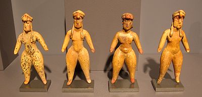
Some of the figurines found in San Miguel Ixtapan indicate an occupation dating back to the formative period, between 800 and 200 BCE, they are very similar to the elaborate Tlapacoya and Tlatilco ceramic; some of them very peculiar represent pregnant women. Others clay figures are similar to those discovered in Teotihuacan phases III and IV (500 and 750 CE) and confirm a continued occupation during the classical period. Much of these objects were found in the deeper layers of the ballgame court. However, the stage of further expansion of San Miguel Ixtapan is during the mesoamerican epiclassical period (750-900 CE). Then is when the principal monuments in the site are built matching the splendor of Xochicalco
Xochicalco
Xochicalco is a pre-Columbian archaeological site in the Municipality of Miacatlán in the western part of the Mexican state of Morelos. The name Xochicalco may be translated from Nahuatl as "in the house of Flowers". The site is located 38 km southwest of Cuernavaca, about 76 miles by road...
, Morelos; Teotenango
Teotenango
Teotenango was in important pre-Hispanic fortified city located in the southern part of the Valley of Toluca. It was initially founded during the last stages of the Teotihuacan civilization by a group generally referred to as the “Teotenancas.” Later, the Matlatzincas conquered the city and...
, South of the Valley of Toluca and Cholula
Cholula (Mesoamerican site)
Cholula , was an important city of pre-Columbian Mesoamerica, dating back to at least the 2nd century BCE, with settlement as a village going back at least some thousand years earlier. The great site of Cholula stands just west of the modern city of Puebla. Its immense pyramid exceeds the Pyramid...
, Puebla, cities that flourished after the decline of Teotihuacan
Teotihuacan
Teotihuacan – also written Teotihuacán, with a Spanish orthographic accent on the last syllable – is an enormous archaeological site in the Basin of Mexico, just 30 miles northeast of Mexico City, containing some of the largest pyramidal structures built in the pre-Columbian Americas...
.
The main pieces that are exhibited in the Museum belong to the epiclassical mesoamerican period, as the anthropomorphic sculptures with crossed arms, ceramic masks with a kind of eye masking, the ballgame court (tlachmalacátl) stone ring and stone disks carved with the image of a dual serpent in the center. This period corresponds to the sculpture area, where there are two anthropomorphic Stelae carved in green stone and embedded in the ground.
During this time the influence of the culture of the Balsas is stronger than ever, it can be appreciated by the large ceramics amount depicting style similarity. Some vessels are identical to those found at the Caracol dam, near Arcelia, Guerrero. The strong cultural exchange that existed between the cultures of Michoacán and Guerrero is notorious, and in the south of the State Mexico, but also the matlatzincas influence is noted.
In the late postclassical period the region was occupied by Aztecs, who imposed tribute or formed army alliances against the Purépecha. Constructive activity is very poor, however this period correspond to some of the burials with lavish offerings. Shell beads, necklaces, cooper needles, earrings, obsidian “bezotes”, spear points, darts and numerous vases accompanied the dead on their journey to the underworld. Many of these objects have been perfectly preserved and can be seen in various Museum showcases.
In the center of town, is the Church of San Miguel Ixtapan, its constructors used carved stone blocks from the archaeological constructions, and in the atrium of the church is another block.
Structures
Upon entering the site, to the right side are two huge earth mounds that contain prehispanic ruins, and to the left is the ballgame court.Prehispanic Scale Model
The Model [Maqueta, ], according to archaeologists, belongs to the early postclassical (900 to 1200 CE), San Miguel Ixtapan continued to be occupied and its buildings were constantly modified.Is a three by four meter basaltic rock outgrowth, in which the ancient inhabitants of the place carved with great skills a series of architectonic elements such as: ballgame courts, platforms or foundations, stairways with sides, roofed temples, etc., depicting an exceptional scale ceremonial center. As a result of investigations of this site and neighboring areas, it has been possible to determine that this architectonic complex does not seem to make reference to any of the known sites to date. Hence, more than a “scale model”, it seems a Votive offering
Votive offering
A votive deposit or votive offering is one or more objects displayed or deposited, without the intention of recovery or use, in a sacred place for broadly religious purposes. Such items are a feature of modern and ancient societies and are generally made in order to gain favor with supernatural...
element in which some type of rites and ceremonies were carried out.
Researchers have called "The model", a rocky outcrop that depicts the architectural design of a city, but the question is: what city?
May well be a city that is still lost; It can also be the drawing of a city yet to be built.
Specialists are not inclined one way or another: it is the architectural model of a City, perhaps conceived at the time, it even contains several spaces (up to five) in the form of ballgame courts.
Ballgame Court
The ballgame court has an outline oriented on an east-west direction; it is capital letter “I” shaped or double “T”, the court area measures 50 meters long by 7.50 wide. Headers at both end measure 15 by 7.8 meters. A particularity of this ballgame court consists of the fact that the land was excavated for its construction below grade, reason why access stairways were built to enter the court. Towards the south side, a platform was added (Platform1), where many human burials were found containing rich offerings, from its characteristics this is placed within the postclassical period.Basement 2
It is said to have been barely explored, due to the tree on top (see Basement 2 picture).On its eastern side, have remains of red stucco. On its western side has a recessed stairway.
Basement 3
It is the most important structure on the site.The structure is composed of three superimposed bodies, with a series of rooms in its superior part, which was accessed by a stairway with intermediate inclined walls (alfardas). The second level of this monument, a complex of overlaid residential-ceremonial enclosures is located distributed on different levels, certainly as a consequence of the need to make modifications to spaces and accesses.
Above the structure is a room, with stucco remains in floor and walls, which probably served for the king to rest.
On the north-west corner is a small niche holding a Tlaloc sculpture, God of water, very important in this area for corn planting, other products and salt collection were the main income sources of the area.
Stairway 4
On the north side of Basement 3, is a stairway leading down from the Tlaloc niche at site level, it is made from large basalt blocks, below is an external patio, surrounded by a wall. There are remains of a drainage system.Sunken Patio 5
On the south side of Basement 3 is the "Patio Hundido” (sunken patio), used hundreds of years ago to make offerings and rituals: strategically located so that attendees could focus on it, inside is a sacrificial stone.It has two access stairways, one with sides finished, leading directly to the “Sculptures Enclosure”.
Structures 6, 7 & 8
These structures are not accessible to visitors, the sunken patio and the structures are chained off.These are located south of basement 3 and west of the sunken patio, at the North West corner.
The enclosures are said to contain the “Recinto de la Banqueta” and the “Recinto de las esculturas”, with accesses facing east and west respectively.
- Recinto de la Esculturas. Is located inside the first structure, a large amount of offerings and figurines was recovered, in addition to two sculptures made with green stone, embedded in the floor, depicting Huiztocihuatl (Godess of salt water) & Tlaloc (Rain God). This structure was called
so called because most of the figurines exhibited in the site Museum from the archaeological site, made from basalt green stone were found in this place.
- Recinto de la Banqueta. It is one of the two rooms, contains stucco remains in floor and walls, which probably served for the king to rest. This place is known as "Recinto de la banqueta". It also contains a kind of ceremonial walkway, displays as ornament a molding with architectonic stone nails.
Many structures are covered with stucco, perhaps to protect them from destruction due to the many invasions suffered with the Aztec occupation.
Site Museum
The museum was opened in 1995 by the “Instituto Mexiquense de Cultura”.San Miguel has a site museum which exhibits a large amount of recovered pieces. This material provided information about the culture and way of life of the ancient inhabitants of the region.
The Museum is small; however keeps a collection of more than 800 items, many in perfect state of conservation and cleverly distributed pursuant to museographer Jorge Carrandi layout. This material has been discovered, mostly as part of mortuary offerings. By ceramic type and style of the sculptures, it has been chronologically placed from the postclassical mesoamerican period.
Some of the ceramic figures include women figurines, some pregnant, dating back to 800 BCE to 200 CE.
Other pieces belong to the splendor period, between 750 and 900 CE. Including vessels, deities representations, feathers and the skeleton of an important man, exhibited as was found in one of the external mounds.
External links
- Encyclopedia of Mexican States.
- Encyclopedia of Mexican States, H. AYUNTAMIENTO DE TEJUPILCO.
- San Miguel Ixtapan (Tejupilco)
Further reading
- Nahua peoples
- NahuatlNahuatlNahuatl is thought to mean "a good, clear sound" This language name has several spellings, among them náhuatl , Naoatl, Nauatl, Nahuatl, Nawatl. In a back formation from the name of the language, the ethnic group of Nahuatl speakers are called Nahua...
- Otomi peopleOtomi peopleThe Otomi people . Smaller Otomi populations exist in the states of Puebla, Mexico, Tlaxcala, Michoacán and Guanajuato. The Otomi language belonging to the Oto-Pamean branch of the Oto-Manguean language family is spoken in many different varieties some of which are not mutually intelligible.One of...
- Otomi languageOtomi languageOtomi is an Oto-Manguean language and one of the indigenous languages of Mexico, spoken by approximately 240,000 indigenous Otomi people in the central altiplano region of Mexico. The language is spoken in many different dialects, some of which are not mutually intelligible, therefore it is in...
- MatlatzincaMatlatzincaMatlatzinca is a name used to refer to different indigenous ethnic groups in the Toluca Valley in the state of México, located in the central highlands of Mexico. The term is applied to the ethnic group inhabiting the valley of Toluca and to their language, Matlatzinca.When used as an ethnonym,...
- Matlatzinca languageMatlatzinca languageThe Matlatzinca language, also called Tlahuica or Ocuiltec, is an indigenous language of Mexico spoken by the Matlatzinca people in the southern part of the State of Mexico. It is an Oto-Manguean language of the Oto-Pamean subgroup...