
San Andrés and Providencia Department
Encyclopedia
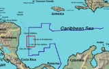
Archipelago of San Andrés, Providencia and Santa Catalina ; or colloquially San Andrés y Providencia is one of the departments
of Colombia
. It consists of two island groups about 775 km (481.6 mi) northwest of Colombia and 220 km (136.7 mi) from the coast of Nicaragua
, and eight outlying banks and reefs. Its capital is San Andrés.
Puritan
s, under the aegis of the Providence Island Company
. These Puritans decided to settle this promising tropical island rather than cold, rocky New England
, but they did not succeed in building a colony similar to New England
. They established slave-worked plantations and engaged in privateering, which led to the capture of the colony by the Spanish
in 1641. In the 1640s, the Puritan-controlled Commonwealth government of England tried to regain the island, but without success. In 1670, English buccaneers led by Henry Morgan
took over the islands. The buccaneers controlled the islands until 1689.
In 1803, Spain assigned the islands and the province of Veraguas (western Panama
and the east coast of Nicaragua
) to the Viceroyalty of New Granada
. The territory was administered from the province of Cartagena
.
On July 4, 1818, French Corsair Louis-Michel Aury
, flying the Argentine flag, captured Old Providence and St. Catherine islands with the help of 400 men and 14 ships. He found the island populated by English-speaking Protestant white persons and their slaves. Aury and his team used the islands as his new base from which to pursue Central American independence. His efforts to also support Bolivar in his fight for Venezuelan and Colombian independence were repeatedly turned down.
After the Spanish colonies became independent, the inhabitants of San Andrés, Providence and St. Catherine voluntarily adhered to the Republic of Gran Colombia
in 1822, who placed them under the administration of the Magdalena Department
. The United Provinces of Central America (UPCA) also claimed the islands. Gran Colombia in turn protested the UPCA's occupation of the eastern coast of Nicaragua. The UPCA broke up in 1838–1840, but Nicaragua carried on the dispute, as did Gran Colombia's successors, New Granada
and Colombia. Colombia established a local administration (intendencia) in the islands in 1912.
In 1928, Colombia and Nicaragua signed the Esguerra-Bárcenas treaty, which gave control of the islands to Colombia. However, when the Sandinista government assumed power in the 1980s, Nicaragua repudiated the treaty. Nicaragua claims that the treaty was signed under United States
pressure and military occupation and thus does not constitute a sovereign decision. Colombia argues that the treaty's final ratification in 1930 (when U.S. forces were already on their way out) confirms its validity. Colombia and Honduras
signed a maritime boundary
treaty in 1999 which implicitly accepts Colombian sovereignty over the islands.
In 2001 Nicaragua filed claims with the International Court of Justice
(ICJ) over the disputed maritime boundary, claiming 50,000 km² in the Caribbean, including the San Andrés and Providencia archipelagoes. Colombia responded that the ICJ has no jurisdiction over the matter, and increased its naval and police presence in the islands. Colombia also defended its claim in the ICJ. On December 13, 2007 the ICJ ruled that the islands were Colombian territory, but left the maritime border dispute unresolved. Colombia and Nicaragua will go through another trial to resolve these claims.
The island of Providencia was hit by Hurricane Beta on October 29, 2005, inflicting minor to moderate damage.
and Roncador Bank
to Colombia and abandoned its claim to Quita Sueño Bank
. The United States still maintains claims over Serranilla Bank
and Bajo Nuevo Bank
and considers them both to be unincorporated territories of the United States.
. However, the policy followed by successive Colombian governments, trying to modify the ethnic composition through extensive migration of Spanish-speaking mainland Colombians, resulted in heightening discontent, even more when the assimilation policy was led by Catholic missions in 1947.
(MIR), won the governor election at the October 28, 2007 election
, with support from the Colombian Conservative Party
and the Radical Change
party. He succeeds a governor from the Colombian Liberal Party
. He got 8,187 votes (38.93 %), Aury Guerrero Bowie (Liberal Party, with support from the Democratic Colombia Party
) 8,160 votes (38.8 %) and Jack Housni Jaller (Social National Unity Party
) 4,063 votes (19.3%). Only 21,991 out of 41,197 potential electors voted in the gubernatorial election.
At the departmental assembly, elected the same day, the 9 seats were distributed among 6 parties: 3 Liberals (Arlington Howard, Qwincy Bowie Gordon and Leroy Carol Bent Archbold), 2 MIR (Jorge Méndez and Freddy Herazo) 2 Democratic Colombia Party (former MP María Teresa Uribe Bent and former Interior Secretary Rafael Gómez Redondo), 2 SNUP (Fernando Cañon Florez and María Said Darwich), 1 Radical Change (Heber Esquivel Benitez) and 1 Conservative (Julio César Gallardo Martínez).
The new mayor of Providence, Janeth Archbold (Team Colombia
party), a political ally of the new governor, was elected with 1,013 votes against Liberal Mark Taylor (515 votes), SNUP Arturo Robinson (514 votes) and Conservative Peter Bent.
s that belong to the Department, including submerged Alicia Shoal.
in the center of the island called Big Pond. The principal town is San Andrés in the north of the island. Another town is San Luis on the east coast. Cayo Johnny (Cayo Sucre) lies 1.5 km ENE of German Point (Punta Norte), the island's northern tip, and Haynes Cay about the same distance east of the island. Cotton Cay is less than 1 km south of San Andrés town, on the northeastern coast.
on Cayo del Norte, at 12°10′N 81°50′W, operating since 1980. It is maintained by the Colombian Navy.
 This atoll is 22 km east-south-east of San Andrés Island and 35 km northeast of Cayos de Alburquerque, at 12°24′N 81°28′W. It is 14 km long and 4 km wide. There are a few sand cay
s in the southeast. The largest ones are Cayo del Este, Cayo Bolivar, West Cay, and Cayo Arena, none of which are higher than 2 metres. All cays are overgrown with palm trees and bushes, and surrounded by mangrove
s. There is a Colombia
n Navy lighthouse on Cayo Bolivar. The cays are regularly visited by fishermen from the Colombian mainland and San Andrés. There are two concrete buildings on Cayo Bolivar, and a few wooden huts on the other cays.
Low Cay, a very small islet, lies more than 10 km further north, at 13°32′N 81°21′W.
, Bajo Nuevo Bank
, Serranilla Bank
, Quita Sueño Bank
, Serrana Bank
, and Roncador Bank
.
s, who are an Afro-Caribbean group, Protestant in religion, speaking San Andrés-Providencia Creole
. Colombia has promoted the migration of Spanish-speaking mainlanders, with Catholic missions participating since 1947. This policy seems to be an answer to growing discontent within the raizal community that could strengthen separatist movements; a raizal majority would in this case win a pro-independence referendum and could be neutralized by outnumbering them with immigrants.
By 2005, Raizals were only 30% of the 90,000 or more inhabitants of the islands, with the rest being mainland Colombian
s. Raizals can speak both Spanish
and English
.
, but also commercially serves the nearby island of Providencia Island
. All being major tourist and vacation spots for South and Central American tourists.
Gustavo Rojas Pinilla International Airport
is also known as Sesquicentenario International Airport. The airport is the 6th busiest airport in Colombia in terms of passengers, with 836,234 in 2006. Most of these passengers come from the continental part of the country, due to poor international direct service to the island. Many international tourists have to fly to one of Colombia's or Panama's largest airports (Bogotá, Medellín, Cali, Panama City) to be able to reach the islands. Although in recent years San Andrés has started to receive seasonal charter flights, mainly from Canada and a few Central American countries.
As of February 2011, there are no commercial passenger flights to San Andrés from Ecuador or Costa Rica. International travelers must fly to continental Colombia or to Panamá (one daily flight) to reach the island.
The airport is one of Colombia's fastest growing airports with a 13.4% increase in the number of passengers between 2005 and 2006.
The airport was the site of an Aires Colombia aircraft crash on August 16, 2010. The Boeing 737-700 left Bogota 2 hours before landing into bad weather with poor visibility condition. The crew reported a lightning strike that temporarily blinded the pilots on very short final. The plane broke up into three parts on the runway, all but 1 of the 126 passengers on board survived. The flight recorders have been removed from the wreckage and the exact causes of the crash are being investigated.
Departments of Colombia
Colombia is an unitary republic formed by thirty-two departments and a Capital District . Each department has a Governor and a Department Assembly , elected by popular vote for a four-year period. The governor cannot be re-elected in consecutive periods...
of Colombia
Colombia
Colombia, officially the Republic of Colombia , is a unitary constitutional republic comprising thirty-two departments. The country is located in northwestern South America, bordered to the east by Venezuela and Brazil; to the south by Ecuador and Peru; to the north by the Caribbean Sea; to the...
. It consists of two island groups about 775 km (481.6 mi) northwest of Colombia and 220 km (136.7 mi) from the coast of Nicaragua
Nicaragua
Nicaragua is the largest country in the Central American American isthmus, bordered by Honduras to the north and Costa Rica to the south. The country is situated between 11 and 14 degrees north of the Equator in the Northern Hemisphere, which places it entirely within the tropics. The Pacific Ocean...
, and eight outlying banks and reefs. Its capital is San Andrés.
History
In 1630, Providence Island was settled by EnglishEngland
England is a country that is part of the United Kingdom. It shares land borders with Scotland to the north and Wales to the west; the Irish Sea is to the north west, the Celtic Sea to the south west, with the North Sea to the east and the English Channel to the south separating it from continental...
Puritan
Puritan
The Puritans were a significant grouping of English Protestants in the 16th and 17th centuries. Puritanism in this sense was founded by some Marian exiles from the clergy shortly after the accession of Elizabeth I of England in 1558, as an activist movement within the Church of England...
s, under the aegis of the Providence Island Company
Providence Island Company
The Providence Company or Providence Island Company was an English chartered company founded in 1629 by a group of Puritans including Robert Rich, 2nd Earl of Warwick in order to settle Providence Island, off the Spanish Mosquito Coast of what became Nicaragua.Besides Lord Warwick, among the twenty...
. These Puritans decided to settle this promising tropical island rather than cold, rocky New England
New England
New England is a region in the northeastern corner of the United States consisting of the six states of Maine, New Hampshire, Vermont, Massachusetts, Rhode Island, and Connecticut...
, but they did not succeed in building a colony similar to New England
New England
New England is a region in the northeastern corner of the United States consisting of the six states of Maine, New Hampshire, Vermont, Massachusetts, Rhode Island, and Connecticut...
. They established slave-worked plantations and engaged in privateering, which led to the capture of the colony by the Spanish
Spain
Spain , officially the Kingdom of Spain languages]] under the European Charter for Regional or Minority Languages. In each of these, Spain's official name is as follows:;;;;;;), is a country and member state of the European Union located in southwestern Europe on the Iberian Peninsula...
in 1641. In the 1640s, the Puritan-controlled Commonwealth government of England tried to regain the island, but without success. In 1670, English buccaneers led by Henry Morgan
Henry Morgan
Admiral Sir Henry Morgan was an Admiral of the Royal Navy, a privateer, and a pirate who made a name for himself during activities in the Caribbean, primarily raiding Spanish settlements...
took over the islands. The buccaneers controlled the islands until 1689.
In 1803, Spain assigned the islands and the province of Veraguas (western Panama
Panama
Panama , officially the Republic of Panama , is the southernmost country of Central America. Situated on the isthmus connecting North and South America, it is bordered by Costa Rica to the northwest, Colombia to the southeast, the Caribbean Sea to the north and the Pacific Ocean to the south. The...
and the east coast of Nicaragua
Nicaragua
Nicaragua is the largest country in the Central American American isthmus, bordered by Honduras to the north and Costa Rica to the south. The country is situated between 11 and 14 degrees north of the Equator in the Northern Hemisphere, which places it entirely within the tropics. The Pacific Ocean...
) to the Viceroyalty of New Granada
Viceroyalty of New Granada
The Viceroyalty of New Granada was the name given on 27 May 1717, to a Spanish colonial jurisdiction in northern South America, corresponding mainly to modern Colombia, Ecuador, Panama, and Venezuela. The territory corresponding to Panama was incorporated later in 1739...
. The territory was administered from the province of Cartagena
Cartagena, Colombia
Cartagena de Indias , is a large Caribbean beach resort city on the northern coast of Colombia in the Caribbean Coast Region and capital of Bolívar Department...
.
On July 4, 1818, French Corsair Louis-Michel Aury
Louis-Michel Aury
Louis-Michel Aury was a French Corsair operating in the Gulf of Mexico and Caribbean during the early 19th century.Aury was born in Paris, France, in about 1788. He served in the French Navy, but from 1802 served in privateer ships...
, flying the Argentine flag, captured Old Providence and St. Catherine islands with the help of 400 men and 14 ships. He found the island populated by English-speaking Protestant white persons and their slaves. Aury and his team used the islands as his new base from which to pursue Central American independence. His efforts to also support Bolivar in his fight for Venezuelan and Colombian independence were repeatedly turned down.
After the Spanish colonies became independent, the inhabitants of San Andrés, Providence and St. Catherine voluntarily adhered to the Republic of Gran Colombia
Gran Colombia
Gran Colombia is a name used today for the state that encompassed much of northern South America and part of southern Central America from 1819 to 1831. This short-lived republic included the territories of present-day Colombia, Venezuela, Ecuador, Panama, northern Peru and northwest Brazil. The...
in 1822, who placed them under the administration of the Magdalena Department
Magdalena Department
Magdalena is a department of Colombia, located to the north of the country by the Caribbean Sea. The capital of the Magdalena Department is Santa Marta and was named after the Magdalena River...
. The United Provinces of Central America (UPCA) also claimed the islands. Gran Colombia in turn protested the UPCA's occupation of the eastern coast of Nicaragua. The UPCA broke up in 1838–1840, but Nicaragua carried on the dispute, as did Gran Colombia's successors, New Granada
Republic of New Granada
The Republic of New Granada was a centralist republic consisting primarily of present-day Colombia and Panama with smaller portions of today's Ecuador, and Venezuela. It was created after the dissolution in 1830 of Gran Colombia. It was later abolished in 1858 when the Granadine Confederation was...
and Colombia. Colombia established a local administration (intendencia) in the islands in 1912.
In 1928, Colombia and Nicaragua signed the Esguerra-Bárcenas treaty, which gave control of the islands to Colombia. However, when the Sandinista government assumed power in the 1980s, Nicaragua repudiated the treaty. Nicaragua claims that the treaty was signed under United States
United States
The United States of America is a federal constitutional republic comprising fifty states and a federal district...
pressure and military occupation and thus does not constitute a sovereign decision. Colombia argues that the treaty's final ratification in 1930 (when U.S. forces were already on their way out) confirms its validity. Colombia and Honduras
Honduras
Honduras is a republic in Central America. It was previously known as Spanish Honduras to differentiate it from British Honduras, which became the modern-day state of Belize...
signed a maritime boundary
Maritime boundary
Maritime boundary is a conceptual means of division of the water surface of the planet into maritime areas that are defined through surrounding physical geography or by human geography. As such it usually includes areas of exclusive national rights over the mineral and biological resources,...
treaty in 1999 which implicitly accepts Colombian sovereignty over the islands.
In 2001 Nicaragua filed claims with the International Court of Justice
International Court of Justice
The International Court of Justice is the primary judicial organ of the United Nations. It is based in the Peace Palace in The Hague, Netherlands...
(ICJ) over the disputed maritime boundary, claiming 50,000 km² in the Caribbean, including the San Andrés and Providencia archipelagoes. Colombia responded that the ICJ has no jurisdiction over the matter, and increased its naval and police presence in the islands. Colombia also defended its claim in the ICJ. On December 13, 2007 the ICJ ruled that the islands were Colombian territory, but left the maritime border dispute unresolved. Colombia and Nicaragua will go through another trial to resolve these claims.
The island of Providencia was hit by Hurricane Beta on October 29, 2005, inflicting minor to moderate damage.
U.S. claims
In the 19th century, the U.S. claimed several uninhabited locations in the area under the Guano Island Act, including several now claimed by Colombia. In 1981, the U.S. ceded its claims to Serrana BankSerrana Bank
The Serrana Bank is one of the few atolls in the Atlantic Ocean. Its mostly underwater reef of about 50 km long and 13 km wide has six cays or islets, the most prominent of which is Southwest Cay.The cays from south to north are:...
and Roncador Bank
Roncador Bank
Roncador Bank is a mostly-submerged atoll with several sandy cays. It lies in the west Caribbean Sea off the coast of Central America. Originally claimed by the United States under the Guano Islands Act of 1856, the atoll was returned by the United States to Colombia on September 17, 1981, as the...
to Colombia and abandoned its claim to Quita Sueño Bank
Quita Sueño Bank
Quita Sueño Bank is a reef formation of Colombia which was once claimed by the United States, located 110 km North-northeast of Providencia Island.-History:...
. The United States still maintains claims over Serranilla Bank
Serranilla Bank
Serranilla Bank is a partially submerged reef, with small uninhabited islets, in the western Caribbean Sea. It is situated about northeast of Punta Gorda, Nicaragua, and roughly southwest of Jamaica. The closest neighbouring land feature is Bajo Nuevo Bank, located 110 km to the east.Serranilla...
and Bajo Nuevo Bank
Bajo Nuevo Bank
Bajo Nuevo Bank, also known as the Petrel Islands , is a small, uninhabited reef with some small islets, covered with grass, located in the western Caribbean Sea at , with a lighthouse on Low Cay at . The closest neighbouring land feature is Serranilla Bank, located to the west.The reef was first...
and considers them both to be unincorporated territories of the United States.
Separatism
In 1903 the local Raizal population rejected an offer from the USA to separate from Colombia, in the wake of PanamaPanama
Panama , officially the Republic of Panama , is the southernmost country of Central America. Situated on the isthmus connecting North and South America, it is bordered by Costa Rica to the northwest, Colombia to the southeast, the Caribbean Sea to the north and the Pacific Ocean to the south. The...
. However, the policy followed by successive Colombian governments, trying to modify the ethnic composition through extensive migration of Spanish-speaking mainland Colombians, resulted in heightening discontent, even more when the assimilation policy was led by Catholic missions in 1947.
2007 elections
A member of the departmental assembly for 15 years, Pedro Gallardo Forbes, of the Regional Integration MovementRegional Integration Movement
The Regional Integration Movement is a political party in Colombia.At the last legislative elections on March 10, 2002, the party won as one of the many small parties parliamentary representation. In the simultaneous legislative elections of 2006, the party won 4 out of 166 Deputies and no senators....
(MIR), won the governor election at the October 28, 2007 election
Colombian regional election, 2007
The Colombian elections of 2007 refers to the democratic elections of October 28, 2007 in the Republic of Colombia. The elections were organized as established by the Colombian Constitution of 1991 by the National Electoral Council to elect Department governors with its respective Department...
, with support from the Colombian Conservative Party
Colombian Conservative Party
The Colombian Conservative Party , is a conservative political party in Colombia. The party was unofficially founded by a group of Revolutionary Commoners during the Revolutionary War for Independence from the Spanish Monarchy and later formally established during the Greater Colombia...
and the Radical Change
Radical Change
Radical Change is a conservative liberal political party in Colombia.At the last legislative elections in Colombia on March 12, 2006, the party became one of the most important in the new congress, receiving 15 seats in the lower house and 20 in the upper house...
party. He succeeds a governor from the Colombian Liberal Party
Colombian Liberal Party
The Colombian Liberal Party is a center-left party in Colombia that adheres to social democracy and social liberalism.The Party was founded in 1848 and, together with the Colombian Conservative Party, subsequently became one of the two main political forces in the country for over a century.After...
. He got 8,187 votes (38.93 %), Aury Guerrero Bowie (Liberal Party, with support from the Democratic Colombia Party
Democratic Colombia Party
The Democratic Colombia Party is a political party in Colombia. The party took part in the parliamentary elections of 2006, in which it won 2 out of 166 deputies and 3 out of 100 senators....
) 8,160 votes (38.8 %) and Jack Housni Jaller (Social National Unity Party
Social National Unity Party
The Social Party of National Unity , or Party of the U is a liberal conservative political party in Colombia. It attempts to unite various parliamentary supporters of Álvaro Uribe, the Uribistas, in one political party. Currently it is Colombia's largest political party.Security is the top...
) 4,063 votes (19.3%). Only 21,991 out of 41,197 potential electors voted in the gubernatorial election.
At the departmental assembly, elected the same day, the 9 seats were distributed among 6 parties: 3 Liberals (Arlington Howard, Qwincy Bowie Gordon and Leroy Carol Bent Archbold), 2 MIR (Jorge Méndez and Freddy Herazo) 2 Democratic Colombia Party (former MP María Teresa Uribe Bent and former Interior Secretary Rafael Gómez Redondo), 2 SNUP (Fernando Cañon Florez and María Said Darwich), 1 Radical Change (Heber Esquivel Benitez) and 1 Conservative (Julio César Gallardo Martínez).
The new mayor of Providence, Janeth Archbold (Team Colombia
Team Colombia
Team Colombia is a conservative political party in Colombia.At the last legislative elections, 10 March 2002, the party won, as one of the many small parties, parliamentary representation. It joined forces with ALAS, another small party, for the 2006 legislative election. In the election of 2006,...
party), a political ally of the new governor, was elected with 1,013 votes against Liberal Mark Taylor (515 votes), SNUP Arturo Robinson (514 votes) and Conservative Peter Bent.
Geography
Besides the San Andrés and Providencia island groups, there are eight atollAtoll
An atoll is a coral island that encircles a lagoon partially or completely.- Usage :The word atoll comes from the Dhivehi word atholhu OED...
s that belong to the Department, including submerged Alicia Shoal.
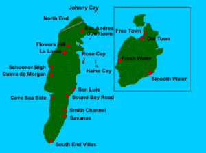
San Andrés Island
This is the main island of the San Andrés group, and the largest of the Departament. It is located at 12°33′N 81°43′W. It measures 12 km in length with a width of 3 km and covers an area of 26 km². There is a tiny lagoonLagoon
A lagoon is a body of shallow sea water or brackish water separated from the sea by some form of barrier. The EU's habitat directive defines lagoons as "expanses of shallow coastal salt water, of varying salinity or water volume, wholly or partially separated from the sea by sand banks or shingle,...
in the center of the island called Big Pond. The principal town is San Andrés in the north of the island. Another town is San Luis on the east coast. Cayo Johnny (Cayo Sucre) lies 1.5 km ENE of German Point (Punta Norte), the island's northern tip, and Haynes Cay about the same distance east of the island. Cotton Cay is less than 1 km south of San Andrés town, on the northeastern coast.
Cayos de Albuquerque (Cayos de S.W., Southwest Cays)
This atoll is southwest of San Andrés at 12°10′N 81°51′W. It is the westernmost point of Colombia. The reef is about 7 km across. In the southern part are Cayo del Norte and Cayo del Sur. Cayo del Norte, the larger of the two, is up to 2 m high and overgrown with palm trees and bushes. Cayo del Sur, a few hundred metres further South, reaches a height of a little more than 1 m and is vegetated with a few bushes, and in the South with mangroves. There is a lighthouseLighthouse
A lighthouse is a tower, building, or other type of structure designed to emit light from a system of lamps and lenses or, in older times, from a fire, and used as an aid to navigation for maritime pilots at sea or on inland waterways....
on Cayo del Norte, at 12°10′N 81°50′W, operating since 1980. It is maintained by the Colombian Navy.
Cayos del Este Sudeste (Courtown Cays, Cayos de E.S.E.)
Cay
A cay , also spelled caye or key, is a small, low-elevation, sandy island formed on the surface of coral reefs. Cays occur in tropical environments throughout the Pacific, Atlantic and Indian Oceans , where they provide habitable and agricultural land for hundreds of thousands of people...
s in the southeast. The largest ones are Cayo del Este, Cayo Bolivar, West Cay, and Cayo Arena, none of which are higher than 2 metres. All cays are overgrown with palm trees and bushes, and surrounded by mangrove
Mangrove
Mangroves are various kinds of trees up to medium height and shrubs that grow in saline coastal sediment habitats in the tropics and subtropics – mainly between latitudes N and S...
s. There is a Colombia
Colombia
Colombia, officially the Republic of Colombia , is a unitary constitutional republic comprising thirty-two departments. The country is located in northwestern South America, bordered to the east by Venezuela and Brazil; to the south by Ecuador and Peru; to the north by the Caribbean Sea; to the...
n Navy lighthouse on Cayo Bolivar. The cays are regularly visited by fishermen from the Colombian mainland and San Andrés. There are two concrete buildings on Cayo Bolivar, and a few wooden huts on the other cays.
Providencia Island (with Santa Catalina Island)
This is the main island of the Providencia group, and the second largest of the department. It is located at 13°21′N 81°22′W. Providencia and Santa Catalina Island (a small satellite island close off its northern end) extend 7.2 km in a north-south direction. The land area of Providencia Island measures 17 km². The mountainous center of Providencia Island rises to three peaks of about the same elevation: roughly 363 meters. The island consists of sedimentary rocks laid down on a former volcano. The chief settlement is Santa Isabel Village aka 'Town' in the north, near Santa Catalina Island. Other villages are Lazy Hill on the west coast, and Bottom House in the southeast.Low Cay, a very small islet, lies more than 10 km further north, at 13°32′N 81°21′W.
Banks and Shoals
Colombia claims sovereignty over six additional outlying banks and shoals: Alice ShoalAlice Shoal
Alice Shoal is a wholly submerged reef, located in the western Caribbean Sea, about 260 kilometres southwest of Jamaica. The mainland of Colombia lies 740 km away to the southeast....
, Bajo Nuevo Bank
Bajo Nuevo Bank
Bajo Nuevo Bank, also known as the Petrel Islands , is a small, uninhabited reef with some small islets, covered with grass, located in the western Caribbean Sea at , with a lighthouse on Low Cay at . The closest neighbouring land feature is Serranilla Bank, located to the west.The reef was first...
, Serranilla Bank
Serranilla Bank
Serranilla Bank is a partially submerged reef, with small uninhabited islets, in the western Caribbean Sea. It is situated about northeast of Punta Gorda, Nicaragua, and roughly southwest of Jamaica. The closest neighbouring land feature is Bajo Nuevo Bank, located 110 km to the east.Serranilla...
, Quita Sueño Bank
Quita Sueño Bank
Quita Sueño Bank is a reef formation of Colombia which was once claimed by the United States, located 110 km North-northeast of Providencia Island.-History:...
, Serrana Bank
Serrana Bank
The Serrana Bank is one of the few atolls in the Atlantic Ocean. Its mostly underwater reef of about 50 km long and 13 km wide has six cays or islets, the most prominent of which is Southwest Cay.The cays from south to north are:...
, and Roncador Bank
Roncador Bank
Roncador Bank is a mostly-submerged atoll with several sandy cays. It lies in the west Caribbean Sea off the coast of Central America. Originally claimed by the United States under the Guano Islands Act of 1856, the atoll was returned by the United States to Colombia on September 17, 1981, as the...
.
Demographics
Before 1960, the population of the islands was almost entirely RaizalRaizal
The Raizals are a Protestant Afro-Caribbean ethnic group, speaking the San Andrés-Providencia Creole, an English Creole, living in the Archipelago of San Andrés, Providencia and Santa Catalina, presently the Colombian San Andrés y Providencia Department, off the Nicaraguan Miskito Coast...
s, who are an Afro-Caribbean group, Protestant in religion, speaking San Andrés-Providencia Creole
San Andrés-Providencia Creole
San Andrés–Providencia Creole is a Creole language spoken in the San Andrés and Providencia Department of Colombia by the natives , very similar to the Miskito Coastal Creole spoken in Bluefields, the Corn Islands and the Mosquito Coast of Nicaragua...
. Colombia has promoted the migration of Spanish-speaking mainlanders, with Catholic missions participating since 1947. This policy seems to be an answer to growing discontent within the raizal community that could strengthen separatist movements; a raizal majority would in this case win a pro-independence referendum and could be neutralized by outnumbering them with immigrants.
By 2005, Raizals were only 30% of the 90,000 or more inhabitants of the islands, with the rest being mainland Colombian
Colombian people
Colombian people are from a multiethnic Spanish speaking nation in South America called Colombia. Colombians are predominantly Roman Catholic and are a mixture of Europeans, Africans, and Amerindians.-Demography:...
s. Raizals can speak both Spanish
Spanish language
Spanish , also known as Castilian , is a Romance language in the Ibero-Romance group that evolved from several languages and dialects in central-northern Iberia around the 9th century and gradually spread with the expansion of the Kingdom of Castile into central and southern Iberia during the...
and English
English language
English is a West Germanic language that arose in the Anglo-Saxon kingdoms of England and spread into what was to become south-east Scotland under the influence of the Anglian medieval kingdom of Northumbria...
.
Airports
The airport serves the cities of San Andrés and San LuisSan Luis
San Luis, the Spanish name for Saint Louis, is a common toponym in parts of the world where that language is or was spoken. It may refer to:*Argentina** San Luis Province** San Luis, Argentina, that province's capital city*Colombia...
, but also commercially serves the nearby island of Providencia Island
Providencia Island
Isla de Providencia or Old Providence is a mountainous Caribbean island. Though it is closer to Nicaragua, it is part of the Archipelago of San Andres, Providencia and Santa Catalina, a department of Colombia, lying midway between Costa Rica and Jamaica...
. All being major tourist and vacation spots for South and Central American tourists.
Gustavo Rojas Pinilla International Airport
Gustavo Rojas Pinilla International Airport
Gustavo Rojas Pinilla International Airport is the leading airport in the archipelago of San Andrés, Providencia and Santa Catalina, which has enough capacity to receive large aircraft, due to a number of charter flights and seasonal in different parts of America and Europe.- Description :The...
is also known as Sesquicentenario International Airport. The airport is the 6th busiest airport in Colombia in terms of passengers, with 836,234 in 2006. Most of these passengers come from the continental part of the country, due to poor international direct service to the island. Many international tourists have to fly to one of Colombia's or Panama's largest airports (Bogotá, Medellín, Cali, Panama City) to be able to reach the islands. Although in recent years San Andrés has started to receive seasonal charter flights, mainly from Canada and a few Central American countries.
As of February 2011, there are no commercial passenger flights to San Andrés from Ecuador or Costa Rica. International travelers must fly to continental Colombia or to Panamá (one daily flight) to reach the island.
The airport is one of Colombia's fastest growing airports with a 13.4% increase in the number of passengers between 2005 and 2006.
The airport was the site of an Aires Colombia aircraft crash on August 16, 2010. The Boeing 737-700 left Bogota 2 hours before landing into bad weather with poor visibility condition. The crew reported a lightning strike that temporarily blinded the pilots on very short final. The plane broke up into three parts on the runway, all but 1 of the 126 passengers on board survived. The flight recorders have been removed from the wreckage and the exact causes of the crash are being investigated.
External links
- ICJ Nicaragua v. Colombia (Preliminary Objections) and (Merits) and 2007 Preliminary Objections Judgment and ASIL and BBC and Colombia President and Colombia MFA and Analysis 20 Hague YIL 75-119 2008
- http://www.sanandres.gov.co/turismo/home.php (English)
- Government Tourism website with small map
- San Andrés Website
- Providencia information (English & Spanish)
- San Andrés & Providencia Website
- Tour Operator in the island, website with satellite map (Spanish)
- Tour Operator with Travel tips and must see in San Andrés in (en;es;de)
- Scuba diving information about San Andrés (Spanish)
- Information on some Atolls (German)
- Information on Colombian lighthouses (German)
- Oceandots
- New York Times article on independence movement