
.gif)
Route 31 (New Jersey)
Encyclopedia
Route 31 is a state highway
in New Jersey
, United States
. It runs 48.93 mi (78.75 km) from U.S. Route 206
(also signed as U.S. Route 1 Business) in Trenton
, Mercer County
north to an intersection with U.S. Route 46
in Buttzville
in White Township
, Warren County
. Along the way, Route 31 heads through the communities of Flemington
, Clinton
and Washington
. Most of the highway is state-maintained; however, the section within the city limits of Trenton is maintained by Mercer County. Much of Route 31 is a two-lane highway that passes through farmland, woodland, and mountainous areas. Two portions of the route—from Trenton to Pennington
and from Ringoes to Clinton—consist of more development.
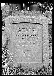
The highway was constructed from 1926 to 1935. Route 31 has carried two different numbers in the past. It was known as Route 30 between 1927 and 1953, when it was renumbered to Route 69 to avoid conflicting with U.S. Route 30
in southern New Jersey. It was renumbered to Route 31 in 1967 due to sign theft
that resulted from the sexual meaning of the number 69
. There were plans made in the late 1960s and early 1970s to build a freeway in the Route 31 corridor that would begin in the Trenton area and extend as far north as Interstate 84
in Port Jervis, New York
; however, it was canceled in the mid-1970s due to opposition from area residents and environmental and financial constraints. In recent years, the portion of Route 31 between Flemington and Clinton has been widened to four lanes. In addition, there was a failed project to build a bypass of Flemington that would have also eliminated the Flemington Circle.
and U.S. Route 206
at the Trenton Battle Monument
in Trenton
, Mercer County
on county-maintained Pennington Road, a two-lane, undivided road. The route passes by residences and some businesses in the northern part of Trenton, crossing County Route 653 (Calhoun Street). Route 31 enters Ewing Township
and becomes state-mantainted at the point where it crosses County Route 634 (Parkway Avenue). The route continues north through suburban residential areas of the township and passes to the west of The College of New Jersey
campus before crossing County Route 636 (Upper Ferry Road/Ewingville Road). It crosses into Hopewell Township
and briefly becomes a four-lane divided highway
as it interchanges with Interstate 95
. Past this interchange, Route 31 continues north as an undivided road through a mix of residences with some businesses, meeting County Route 546
and County Route 640 at a traffic circle
. It continues past the circle as a two-lane, undivided road and bypasses Pennington
to the west, running through wooded residential areas. The route briefly skirts into Pennington twice, where it is a divided highway as it crosses over CSX's Trenton Subdivision
. Route 31 enters Pennington again, heading through a mix of residential areas and commercial establishments, before heading back into Hopewell Township. Here, the road meets County Route 640 (North Main Street) again, and heads north into farmland and woodland with some homes. It eventually turns to the northwest and crosses County Route 518
(Lambertville-Hopewell Road).
 Upon crossing County Route 518, Route 31 enters East Amwell Township
, Hunterdon County and continues through areas of farm fields and woods with intermittent residences and businesses. The route eventually forms the border between East Amwell Township and West Amwell Township
and intersects County Route 579
(Harbourton Road). The two routes run concurrent
to the northwest, becoming a three-lane road with a center left-turn lane that crosses entirely into East Amwell Township before resuming along the border of East and West Amwell Townships. The road becomes a divided highway and crosses entirely into East Amwell Township again before it comes to an interchange with U.S. Route 202
, where County Route 579 continues north into Ringoes
and Route 31 heads north along U.S. Route 202, a four-lane, divided highway with intersections featuring jughandle
ramps.
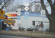
U.S. Route 202 and Route 31 head to the north, coming to an intersection with Old York Road
, which heads to the southwest as Route 179 and to the northeast as County Route 514
. Past this intersection, the road forms the border between East Amwell Township to the west and Raritan Township
to the east before crossing entirely into Raritan Township. The road continues north through farms, reaching commercial development as it approaches the Flemington
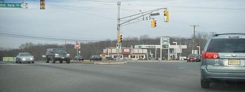
area. Past an intersection with County Route 611 (South Main Street), the road widens to six lanes and crosses into Flemington. The road comes to the Flemington Circle where U.S. Route 202 continues to the northeast, Route 12 heads to the west, and Route 31 continues to the north on a five-lane, undivided road.
 The route crosses back into Raritan Township, where it briefly becomes a four-lane divided highway before reentering Flemington. Not long afterward, it heads into Raritan Township again, where it crosses County Route 523
(Walter E. Foran Boulevard) and passes by the former site of Flemington Speedway
, now a commercial development called Raritan Town Square. Route 31 passes through suburban development before turning into a four-lane, divided highway with some intersections controlled by jughandles and crossing over the South Branch Raritan River
into Readington Township
. It continues north through a mix of farms and wooded areas with some residential areas, crossing into Clinton Township
.
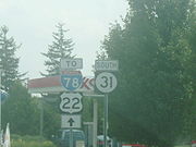
Route 31 comes to an interchange with Interstate 78
and U.S. Route 22
, where it turns to the northwest into a more developed setting and interchanges with Route 173. The road runs through Clinton Town
, where it crosses the South Branch Raritan River again. Back in Clinton Township, Route 31 intersects County Route 513
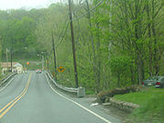
(Halstead Street), forming a concurrency with that route and running along the eastern shore of Spruce Run Reservoir. County Route 513 splits from Route 31 by heading north on West Main Street and Route 31 continues north, narrowing to a two-lane undivided road. The route crosses into Lebanon Township
, where it heads northwest across the wooded Musconetcong Mountains. Route 31 passes through Glen Gardner
, which it enters upon crossing Sprunce Run, before heading into Hampton
, where it heads west through that community as a three-lane road with two southbound lanes and one northbound lane.
into Washington Township
, Warren County
, where it heads north into the agricultural Musconetcong Valley. It heads into Washington Borough
, where the road becomes four lanes and crosses Route 57 (Washington Avenue). Past the Route 57 intersection, Route 31 narrows to three lanes, and becomes a two-lane road again as it crosses back into Washington Township at the Essex Road intersection. It heads into farmland before turning northwest and heading across Oxford Mountain, entering Mansfield Township
. While crossing Oxford Mountain, Route 31 skirts along the border between Mansfield Township and Washington Township. The route enters Oxford Township
, where it heads through the community of Oxford as a four-lane road. Route 31 continues north through a mix of woods and agricultural areas past Oxford, crossing into White Township
at the East Quarry Road intersection and coming to its terminus at U.S. Route 46
.
 Before the state recevied ownership of Route 31, the portion of the highway from Clinton to Oxford was part of the Spruce Run Turnpike. The turnpike was chartered by the New Jersey State Assembly on February 6, 1813 and was maintained and tolled by the Spruce Run Turnpike Company. The turnpike served as a connector along the old Hopewell Road from modern-day Lambertville
(then called Georgetown) to New Brunswick
. The road also served as a highly-used connector route for the Jersey and Castenoga wagon lines, which served both of the aforementioned communities. The route from Trenton to Pennington was part of the Pennington Turnpike, another privately maintained pre-designation highway. The turnpike was chartered on March 17, 1854 by the General Assembly along an alignment of the old Pennington Road. The turnpike road was to be constructed no further than 32 feet (9.8 m) in breadth, and to be made out of stone, plank or gravel. The turnpike cost one cent for every carriage or sled pulled by horses or mules (and one cent more for every animal), five mills for horse and rider and every dozen of pigs and sheep. It cost two cents to move a dozen cattle, mules or horses. Fines were levied as high as $10 (1854 USD) to anyone who vandalized any structure along the turnpike. If the company did not construct their highway in six years, the state would then take over and make it a public highway. On November 1, 1898, the 7 miles (11.3 km) long turnpike, made mostly of stone, was taken over by the state at a cost of $31,661.87 (1898 USD). Repairs were slated to be completed on the road by October 31, 1899. Also on March 17, 1854, the state legislature made the charter official for the Hopewell and Ewing Turnpike, which used the portion of NJ 31 from Pennington to the current-day intersection with County Route 654. The turnpike was taken over by the state in 1897 and the privately-maintained company was dissolved.
The formation of current-day Route 31 began around 1916, when a portion of the highway, along the community of Hampton was taken over by the state and was repaired to state standards for $300 (1916 USD). In 1923, the state of New Jersey passed the Good Roads Act, which greatly expanded the state highway system in New Jersey. This act took over pre-existing highways and rebuilt them to a standard mandated by the state. Construction began on Route 31 in 1926, when the State Highway Department began work at the southern terminus in Trenton. A total of 11 bridges were constructed along the highway during this time, signifying the route's construction northward. The oldest ones, dating back to 1926, were located in Ewing Township and Oxford Township. The one in Ewing Township was along the first portion of the highway to be constructed.
By 1929, the construction had reached Lawrence Township, where another long stretch of highway was built. During 1930, the construction had reached Clinton, Glen Gardener, and Washington. Construction of the highway progressed northbound, with sections of the Mercer-Hunterdon-Warren route reaching Hunterdon County in 1931. The Hunterdon County portion up to the Musconetcong River was constructed for six months, with completion in October 1931. Construction of the highway northward from the Musconetcong River started in October of the same year. The mainline construction reached the northern terminus in Buttzville in 1932. The route, although the construction had reached its northern end, was not complete due to bypasses around Clinton and Pennington were proposed to be built. These bypasses were never constructed, and during 1934, more portions of the highway in Hunterdon County were finished. The route was completed in 1935, providing an uninterrupted route from the capital city of Trenton to northern Warren County.
 What is today Route 31 was defined in the 1927 New Jersey state highway renumbering
as Route 30, a highway that began in Trenton and ended in Buttzville. In the 1953 renumbering, Route 30 was renumbered as Route 69, as the number conflicted with U.S. Route 30
in southern New Jersey. The bypass of Ringoes, shared with U.S. Route 202, opened in the 1960s. Due to the sexual meaning of the number
and resulting sign theft
, Route 69 was changed in 1967 to Route 31.
A limited-access freeway was once planned to serve traffic along the Route 31 (then Route 69) corridor. Plans came forth in the 1960s for a highway to run along Route 69 from the in-construction U.S. Route 1
freeway (then designated Route 174) to the U.S. Route 202 freeway in Ringoes. The estimated cost to build the highway according to the proposal estimated to $18 million, with construction completing in 1975. Preparing for construction of the new highway, the New Jersey Department of Transportation
acquired right-of-way in the area of Ewing Township, including portions between Ewingville Road (Mercer County Route 636) and Bull Run Road.
There were plans to extend the freeway further in both directions, including northward to Interstate 80
in Hope Township
and southward to Interstate 195
. Each of these two extensions were brought forth in the 1960s, and were later shelved due to lack of support. In the early 1970s, a 36 miles (57.9 km) long extension of Route 31 was proposed from Oxford, connecting the highway with the proposed Route 23 freeway to Interstate 84
near Port Jervis, New York
. This northern freeway extension of Route 31 was to be known as Route F-31 and the Foothills Freeway, and was to run through the Kittatinny Mountains
, passing through Stokes State Forest
and High Point State Park. The proposal gave an estimated price tag of about $105 million (1970s USD). The northern freeway faced high opposition from residents living in Warren and Sussex counties, who feared environmental damage. A group called Opponents of the Foothills Freeway formed to prevent the road from being built. Along with the growing opposition, environmental and financial issues arose, causing the New Jersey Department of Transportation to cancel the Route 31 from being built mid-1970s.
Following the completion of Interstate 287
's New Jersey portion in 1993, more out-of-state tractor trailer drivers began to use the alignment of Route 31 as a toll-free alternative to the New Jersey Turnpike
. On July 16, 1999, oversize trucks were banned from using Route 31 as part of a larger statewide ban imposed on New Jersey roads not a part of the National Highway System
by then-governor Christine Todd Whitman
. The legislation had a significant effect on trucks that followed Route 31 as it forced them to use Interstate 287 and the New Jersey Turnpike instead. In the mid-2000s, the portion of Route 31 was widened during extensive construction between Flemington and Clinton that widened the road to four lanes.
The parkway was to be built as a two-lane alternative to Route 31 defining the border of the suburban and rural portions of Flemington Borough and Raritan Township. Along with the new parkway, a brand-new local street network was proposed to help support the new alignment. These would minimize the pressure of traffic on Route 31 and include better roads for bicycles and pedestrians. More direct routes to different portions of the community would be provided to maintain the community's character. The proposed parkway was to also help upgrade the sensitive history along the South Branch River. According to the 2008 highway plans, the South Branch Parkway would cost the state more than $2.2 million (2008 USD) in funds to put together the survey of lands in the proposed alignment. Some of these funds for the survey were originally intended to go towards the removal of the Flemington Circle.
State highway
State highway, state road or state route can refer to one of three related concepts, two of them related to a state or provincial government in a country that is divided into states or provinces :#A...
in New Jersey
New Jersey
New Jersey is a state in the Northeastern and Middle Atlantic regions of the United States. , its population was 8,791,894. It is bordered on the north and east by the state of New York, on the southeast and south by the Atlantic Ocean, on the west by Pennsylvania and on the southwest by Delaware...
, United States
United States
The United States of America is a federal constitutional republic comprising fifty states and a federal district...
. It runs 48.93 mi (78.75 km) from U.S. Route 206
U.S. Route 206
U.S. Route 206 is a long north–south United States highway in New Jersey and Pennsylvania, United States. Only about a half a mile of its length is in Pennsylvania; the Milford-Montague Toll Bridge carries it over the Delaware River into New Jersey, where it is the remainder of the route...
(also signed as U.S. Route 1 Business) in Trenton
Trenton, New Jersey
Trenton is the capital of the U.S. state of New Jersey and the county seat of Mercer County. As of the 2010 United States Census, Trenton had a population of 84,913...
, Mercer County
Mercer County, New Jersey
As of the census of 2000, there were 350,761 people, 125,807 households, and 86,303 families residing in the county. The population density was 1,552 people per square mile . There were 133,280 housing units at an average density of 590 per square mile...
north to an intersection with U.S. Route 46
U.S. Route 46
U.S. Route 46 is an east–west U.S. Highway, running for , completely within the state of New Jersey. The west end is at an interchange with Interstate 80 and Route 94 in Columbia, Warren County on the Delaware River...
in Buttzville
Buttzville, New Jersey
Buttzville is an unincorporated community in White Township, Warren County, New Jersey, United States. It lies along U.S. Route 46 at the north end of Route 31 ....
in White Township
White Township, New Jersey
-Demographics:As of the census of 2000, there were 4,245 people, 1,668 households, and 1,179 families residing in the township. The population density was 155.1 people per square mile . There were 1,770 housing units at an average density of 64.7 per square mile...
, Warren County
Warren County, New Jersey
Warren County is a county located in the U.S. state of New Jersey. As of the 2010 Census, the population was 108,692. Its county seat is Belvidere...
. Along the way, Route 31 heads through the communities of Flemington
Flemington, New Jersey
Flemington is a borough in Hunterdon County, New Jersey, United States. As of the United States 2010 Census, the borough population was 4,581. It is the county seat of Hunterdon County....
, Clinton
Clinton, New Jersey
Clinton is a Town in Hunterdon County, New Jersey on the South Branch of the Raritan River. As of the 2010 United States Census, the town population was 2,719....
and Washington
Washington, New Jersey
Washington is a borough in Warren County, New Jersey, United States. As of the United States 2010 Census, the borough population was 6,461. The borough is located in the eastern most region of the Lehigh Valley....
. Most of the highway is state-maintained; however, the section within the city limits of Trenton is maintained by Mercer County. Much of Route 31 is a two-lane highway that passes through farmland, woodland, and mountainous areas. Two portions of the route—from Trenton to Pennington
Pennington, New Jersey
Pennington is a Borough in Mercer County, New Jersey, United States. As of the 2010 United States Census, the borough population was 2,585.Pennington was established as a borough by an Act of the New Jersey Legislature on January 31, 1890, from portions of Hopewell Township, based on the results of...
and from Ringoes to Clinton—consist of more development.
The highway was constructed from 1926 to 1935. Route 31 has carried two different numbers in the past. It was known as Route 30 between 1927 and 1953, when it was renumbered to Route 69 to avoid conflicting with U.S. Route 30
U.S. Route 30 in New Jersey
U.S. Route 30 is a U.S. highway running from Astoria, Oregon east to Atlantic City, New Jersey. In the U.S. state of New Jersey, US 30 runs from the Benjamin Franklin Bridge at the Delaware River in Camden, Camden County while concurrent with Interstate 676 southeast to Virginia...
in southern New Jersey. It was renumbered to Route 31 in 1967 due to sign theft
Street sign theft
Street sign theft occurs when street signs are stolen, often to be used as decorations, but also sometimes to avoid obeying the law by claiming later the sign was not there. Although the theft often seems arbitrary, signs that are unusual or amusing tend to be stolen more frequently...
that resulted from the sexual meaning of the number 69
69 sex position
Sixty-nine or 69, also known by its French name soixante-neuf , is a group of sex positions in which two people align themselves so that each person's mouth is near the other's genitals, simultaneously performing oral sex. The participants are thus mutually inverted like the numerals 6 and 9 in...
. There were plans made in the late 1960s and early 1970s to build a freeway in the Route 31 corridor that would begin in the Trenton area and extend as far north as Interstate 84
Interstate 84 (east)
Interstate 84 is an Interstate Highway extending from Dunmore, Pennsylvania at an interchange with Interstate 81 to Sturbridge, Massachusetts, at an interchange with the Massachusetts Turnpike . I-84 has mile-log junction numbering in Pennsylvania; otherwise, exit numbers are roughly sequential...
in Port Jervis, New York
Port Jervis, New York
Port Jervis is a city on the Delaware River in western Orange County, New York, with a population of 8,860 at the 2000 census. The communities of Deerpark, Huguenot, Sparrowbush, and Greenville are adjacent to Port Jervis, and the towns of Montague, New Jersey and Matamoras, Pennsylvania face the...
; however, it was canceled in the mid-1970s due to opposition from area residents and environmental and financial constraints. In recent years, the portion of Route 31 between Flemington and Clinton has been widened to four lanes. In addition, there was a failed project to build a bypass of Flemington that would have also eliminated the Flemington Circle.
Mercer County
Route 31 heads north from U.S. Route 1 BusinessU.S. Route 1 Business (Trenton, New Jersey)
U.S. Route 1 Business is a four-lane surface road that provides an alternate to the Trenton Freeway northeast of Trenton in Mercer County, New Jersey. The route is long and runs between US 1 in Trenton and Lawrence Township. On the border of Trenton and Lawrence Township, US 1 Business...
and U.S. Route 206
U.S. Route 206
U.S. Route 206 is a long north–south United States highway in New Jersey and Pennsylvania, United States. Only about a half a mile of its length is in Pennsylvania; the Milford-Montague Toll Bridge carries it over the Delaware River into New Jersey, where it is the remainder of the route...
at the Trenton Battle Monument
Trenton Battle Monument
The Trenton Battle Monument is a column-type monument in Trenton, New Jersey. It commemorates the December 26, 1776 Battle of Trenton, a pivotal victory for the Continental forces during the American Revolutionary War.-Description:...
in Trenton
Trenton, New Jersey
Trenton is the capital of the U.S. state of New Jersey and the county seat of Mercer County. As of the 2010 United States Census, Trenton had a population of 84,913...
, Mercer County
Mercer County, New Jersey
As of the census of 2000, there were 350,761 people, 125,807 households, and 86,303 families residing in the county. The population density was 1,552 people per square mile . There were 133,280 housing units at an average density of 590 per square mile...
on county-maintained Pennington Road, a two-lane, undivided road. The route passes by residences and some businesses in the northern part of Trenton, crossing County Route 653 (Calhoun Street). Route 31 enters Ewing Township
Ewing Township, New Jersey
-Demographics:As of the 2010 Census, there were 35,790 people, 13,171 households, and 7,980 families residing in the township. There were 13,926 housing units. The racial makeup of the township was 63.1% White, 27.6% African American, 0.3% Native American, 4.3% Asian, 0.0% Pacific Islander, 2.2%...
and becomes state-mantainted at the point where it crosses County Route 634 (Parkway Avenue). The route continues north through suburban residential areas of the township and passes to the west of The College of New Jersey
The College of New Jersey
The College of New Jersey, abbreviated TCNJ, is a public, coeducational university located in Ewing Township, New Jersey, a suburb of Trenton....
campus before crossing County Route 636 (Upper Ferry Road/Ewingville Road). It crosses into Hopewell Township
Hopewell Township, Mercer County, New Jersey
As of the 2010 United States Census, the township's population was 17,304. The racial makeup of the township was 86.7% White, 2.1% African American, 0.1% Native American, 8.9% Asian, 0.0% Pacific Islander, 0.5% from other races, and 1.7% from two or more races...
and briefly becomes a four-lane divided highway
Divided Highway
Divided Highway is a compilation album by American rock band The Doobie Brothers, released in 2003. . All tracks are taken from the albums Cycles and Brotherhood .-Track listing:...
as it interchanges with Interstate 95
Interstate 95 in New Jersey
Interstate 95 is a major Interstate Highway that traverses the full extent of the East Coast of the United States, from Florida to Maine...
. Past this interchange, Route 31 continues north as an undivided road through a mix of residences with some businesses, meeting County Route 546
County Route 546 (New Jersey)
County Route 546, abbreviated CR 546, is a county highway in the U.S. state of New Jersey. The highway begins at the Washington Crossing Bridge at Titusville, New Jersey and extends from Route 29 in Hopewell Township to U.S...
and County Route 640 at a traffic circle
Traffic circle
A traffic circle or rotary is a type of circular intersection in which traffic must travel in one direction around a central island. In some countries, traffic entering the circle has the right-of-way and drivers in the circle must yield. In many other countries, traffic entering the circle must...
. It continues past the circle as a two-lane, undivided road and bypasses Pennington
Pennington, New Jersey
Pennington is a Borough in Mercer County, New Jersey, United States. As of the 2010 United States Census, the borough population was 2,585.Pennington was established as a borough by an Act of the New Jersey Legislature on January 31, 1890, from portions of Hopewell Township, based on the results of...
to the west, running through wooded residential areas. The route briefly skirts into Pennington twice, where it is a divided highway as it crosses over CSX's Trenton Subdivision
Trenton Subdivision
The Trenton Subdivision is a railroad line owned by CSX Transportation in the U.S. states of Pennsylvania and New Jersey. The line runs from Park Junction in Philadelphia, Pennsylvania northeast to Manville, New Jersey along a former Reading Company line....
. Route 31 enters Pennington again, heading through a mix of residential areas and commercial establishments, before heading back into Hopewell Township. Here, the road meets County Route 640 (North Main Street) again, and heads north into farmland and woodland with some homes. It eventually turns to the northwest and crosses County Route 518
County Route 518 (New Jersey)
County Route 518 is a county highway in the U.S. state of New Jersey. The highway extends from Route 165 in Lambertville to Lincoln Highway in Franklin Township...
(Lambertville-Hopewell Road).
Hunterdon County
East Amwell Township, New Jersey
-History:During the American Revolutionary War, a small but important skirmish occurred in East Amwell when local militia under Capt. John Schenck ambushed a party of British dragoons near Larison's Corner...
, Hunterdon County and continues through areas of farm fields and woods with intermittent residences and businesses. The route eventually forms the border between East Amwell Township and West Amwell Township
West Amwell Township, New Jersey
The Delaware River separates West Amwell from the Commonwealth of Pennsylvania.-Demographics:As of the census of 2000, there were 2,383 people, 949 households, and 696 families residing in the township. The population density was 109.7 people per square mile . There were 984 housing units at an...
and intersects County Route 579
County Route 579 (New Jersey)
County Route 579, abbreviated CR 579, is a county highway in the U.S. state of New Jersey. The highway extends from John Fitch Parkway in Trenton to Route 173 in Greenwich Township.-Mercer County:...
(Harbourton Road). The two routes run concurrent
Concurrency (road)
A concurrency, overlap, or coincidence in a road network is an instance of one physical road bearing two or more different highway, motorway, or other route numbers...
to the northwest, becoming a three-lane road with a center left-turn lane that crosses entirely into East Amwell Township before resuming along the border of East and West Amwell Townships. The road becomes a divided highway and crosses entirely into East Amwell Township again before it comes to an interchange with U.S. Route 202
U.S. Route 202 in New Jersey
U.S. Route 202 is a U.S. Highway running from New Castle, Delaware northeast to Bangor, Maine. In the U.S. state of New Jersey, the route runs from the New Hope-Lambertville Toll Bridge over the Delaware River at the Pennsylvania border in Delaware Township, Hunterdon County near Lambertville...
, where County Route 579 continues north into Ringoes
Ringoes, New Jersey
Ringoes is an unincorporated area located within East Amwell Township, in Hunterdon County, New Jersey. The community is served by the United States Postal Service as ZIP Code 08551. As of the United States 2000 Census, the population for ZIP Code Tabulation Area 08551 was 5,082.-History:Ringoes is...
and Route 31 heads north along U.S. Route 202, a four-lane, divided highway with intersections featuring jughandle
Jughandle
A jughandle is a type of ramp or slip road that changes the way traffic turns left at at-grade intersections. Instead of a standard left turn being made from the left lane, left-turning traffic uses a ramp on the right side of the road...
ramps.
U.S. Route 202 and Route 31 head to the north, coming to an intersection with Old York Road
Old York Road
Old York Road or King's Highway is a roadway that was built in the 18th century to connect Philadelphia, Pennsylvania with New York City, New York. Through New Jersey it was built along the Raritan "Naraticong Trail"...
, which heads to the southwest as Route 179 and to the northeast as County Route 514
County Route 514 (New Jersey)
County Route 514 is a county highway in the U.S. state of New Jersey. The highway extends from US 202 in East Amwell Township to Bayway Avenue in Elizabeth...
. Past this intersection, the road forms the border between East Amwell Township to the west and Raritan Township
Raritan Township, New Jersey
Raritan Township is a Township in Hunterdon County, New Jersey, United States. As of the United States 2010 Census, the township population was 22,185...
to the east before crossing entirely into Raritan Township. The road continues north through farms, reaching commercial development as it approaches the Flemington
Flemington, New Jersey
Flemington is a borough in Hunterdon County, New Jersey, United States. As of the United States 2010 Census, the borough population was 4,581. It is the county seat of Hunterdon County....
area. Past an intersection with County Route 611 (South Main Street), the road widens to six lanes and crosses into Flemington. The road comes to the Flemington Circle where U.S. Route 202 continues to the northeast, Route 12 heads to the west, and Route 31 continues to the north on a five-lane, undivided road.
County Route 523 (New Jersey)
County Route 523 is a county highway in the U.S. state of New Jersey. The highway extends from Main Street in Stockton to Hillside Avenue in Bedminster Township.-Hunterdon County:...
(Walter E. Foran Boulevard) and passes by the former site of Flemington Speedway
Flemington Speedway
Flemington Speedway was a motor racing circuit in Flemington, New Jersey which operated from 1915 to 2002. The track is most known for hosting four NASCAR Craftsman Truck Series races and its pioneering use of foam blocks used to lessen the impact of crashes, which led to the adoption of the SAFER...
, now a commercial development called Raritan Town Square. Route 31 passes through suburban development before turning into a four-lane, divided highway with some intersections controlled by jughandles and crossing over the South Branch Raritan River
South Branch Raritan River
The South Branch Raritan River is a tributary of the Raritan River in central New Jersey in the United States.The source of the South Branch is the outflow from Budd Lake, a glacial remnant located a few miles northeast of Hackettstown...
into Readington Township
Readington Township, New Jersey
Readington Township is a Township located in the easternmost portion of Hunterdon County, New Jersey. As of the 2010 United States Census, the township population was 16,126...
. It continues north through a mix of farms and wooded areas with some residential areas, crossing into Clinton Township
Clinton Township, New Jersey
Clinton Township is a Township in Hunterdon County, New Jersey, United States. As of the United States 2010 Census, the township population was 13,478....
.
Route 31 comes to an interchange with Interstate 78
Interstate 78 in New Jersey
Interstate 78 is an east–west route stretching from Union Township, Lebanon County, Pennsylvania to New York City. In New Jersey, I-78 is called the Phillipsburg–Newark Expressway and the Newark Bay Extension of the New Jersey Turnpike...
and U.S. Route 22
U.S. Route 22 in New Jersey
U.S. Route 22 is a U.S. highway stretching from Cincinnati, Ohio in the west to Newark, New Jersey in the east. In New Jersey, the route runs for from the Easton-Phillipsburg Toll Bridge over the Delaware River in Phillipsburg, Warren County to Interstate 78 , US 1/9, and Route 21 at the Newark...
, where it turns to the northwest into a more developed setting and interchanges with Route 173. The road runs through Clinton Town
Clinton, New Jersey
Clinton is a Town in Hunterdon County, New Jersey on the South Branch of the Raritan River. As of the 2010 United States Census, the town population was 2,719....
, where it crosses the South Branch Raritan River again. Back in Clinton Township, Route 31 intersects County Route 513
County Route 513 (New Jersey)
County Route 513 is a county highway in the U.S. state of New Jersey. The highway extends from Kingwood Avenue in Frenchtown to Lakeside Road in West Milford...
(Halstead Street), forming a concurrency with that route and running along the eastern shore of Spruce Run Reservoir. County Route 513 splits from Route 31 by heading north on West Main Street and Route 31 continues north, narrowing to a two-lane undivided road. The route crosses into Lebanon Township
Lebanon Township, New Jersey
-Demographics:As of the census of 2000, there were 5,816 people, 1,963 households, and 1,556 families residing in the township. The population density was 183.5 people per square mile . There were 2,020 housing units at an average density of 63.7 per square mile...
, where it heads northwest across the wooded Musconetcong Mountains. Route 31 passes through Glen Gardner
Glen Gardner, New Jersey
Glen Gardner is a borough in Hunterdon County, New Jersey, United States. At the time of the United States 2010 Census, the borough population was 1,704....
, which it enters upon crossing Sprunce Run, before heading into Hampton
Hampton, New Jersey
Hampton is a Borough in Hunterdon County, New Jersey, United States. As of the United States 2010 Census, the borough population was 1,401.What is now Hampton was originally incorporated by an Act of the New Jersey Legislature as Junction Borough on February 20, 1895, from portions of both Lebanon...
, where it heads west through that community as a three-lane road with two southbound lanes and one northbound lane.
Warren County
Route 31 crosses the Musconetcong RiverMusconetcong River
The Musconetcong River is a tributary of the Delaware River in northwestern New Jersey in the United States. It flows through the rural mountainous country of northwestern New Jersey. Part of it is a National Wild and Scenic River....
into Washington Township
Washington Township, Warren County, New Jersey
Washington Township is a Township in Warren County, New Jersey, United States. As of the United States 2010 Census, the township population was 6,651. It is part of the eastern most region of the Lehigh Valley. It is one of six municipalities in New Jersey under the name Washington...
, Warren County
Warren County, New Jersey
Warren County is a county located in the U.S. state of New Jersey. As of the 2010 Census, the population was 108,692. Its county seat is Belvidere...
, where it heads north into the agricultural Musconetcong Valley. It heads into Washington Borough
Washington, New Jersey
Washington is a borough in Warren County, New Jersey, United States. As of the United States 2010 Census, the borough population was 6,461. The borough is located in the eastern most region of the Lehigh Valley....
, where the road becomes four lanes and crosses Route 57 (Washington Avenue). Past the Route 57 intersection, Route 31 narrows to three lanes, and becomes a two-lane road again as it crosses back into Washington Township at the Essex Road intersection. It heads into farmland before turning northwest and heading across Oxford Mountain, entering Mansfield Township
Mansfield Township, Warren County, New Jersey
-Demographics:As of the census of 2000, there were 6,653 people, 2,334 households, and 1,750 families residing in the township. The population density was 222.3 people per square mile . There were 2,415 housing units at an average density of 80.7 per square mile...
. While crossing Oxford Mountain, Route 31 skirts along the border between Mansfield Township and Washington Township. The route enters Oxford Township
Oxford Township, New Jersey
Oxford Township is a Township in Warren County, New Jersey, United States. As of the United States 2010 Census, the township population was 2,514...
, where it heads through the community of Oxford as a four-lane road. Route 31 continues north through a mix of woods and agricultural areas past Oxford, crossing into White Township
White Township, New Jersey
-Demographics:As of the census of 2000, there were 4,245 people, 1,668 households, and 1,179 families residing in the township. The population density was 155.1 people per square mile . There were 1,770 housing units at an average density of 64.7 per square mile...
at the East Quarry Road intersection and coming to its terminus at U.S. Route 46
U.S. Route 46
U.S. Route 46 is an east–west U.S. Highway, running for , completely within the state of New Jersey. The west end is at an interchange with Interstate 80 and Route 94 in Columbia, Warren County on the Delaware River...
.
Old roads and construction
Lambertville, New Jersey
Lambertville is a city in Hunterdon County, New Jersey, United States. As of the 2010 United States Census, the city population was 3,906.Lambertville was originally incorporated as a town by an Act of the New Jersey Legislature on March 1, 1849, from portions of West Amwell Township...
(then called Georgetown) to New Brunswick
New Brunswick, New Jersey
New Brunswick is a city in Middlesex County, New Jersey, USA. It is the county seat and the home of Rutgers University. The city is located on the Northeast Corridor rail line, southwest of Manhattan, on the southern bank of the Raritan River. At the 2010 United States Census, the population of...
. The road also served as a highly-used connector route for the Jersey and Castenoga wagon lines, which served both of the aforementioned communities. The route from Trenton to Pennington was part of the Pennington Turnpike, another privately maintained pre-designation highway. The turnpike was chartered on March 17, 1854 by the General Assembly along an alignment of the old Pennington Road. The turnpike road was to be constructed no further than 32 feet (9.8 m) in breadth, and to be made out of stone, plank or gravel. The turnpike cost one cent for every carriage or sled pulled by horses or mules (and one cent more for every animal), five mills for horse and rider and every dozen of pigs and sheep. It cost two cents to move a dozen cattle, mules or horses. Fines were levied as high as $10 (1854 USD) to anyone who vandalized any structure along the turnpike. If the company did not construct their highway in six years, the state would then take over and make it a public highway. On November 1, 1898, the 7 miles (11.3 km) long turnpike, made mostly of stone, was taken over by the state at a cost of $31,661.87 (1898 USD). Repairs were slated to be completed on the road by October 31, 1899. Also on March 17, 1854, the state legislature made the charter official for the Hopewell and Ewing Turnpike, which used the portion of NJ 31 from Pennington to the current-day intersection with County Route 654. The turnpike was taken over by the state in 1897 and the privately-maintained company was dissolved.
The formation of current-day Route 31 began around 1916, when a portion of the highway, along the community of Hampton was taken over by the state and was repaired to state standards for $300 (1916 USD). In 1923, the state of New Jersey passed the Good Roads Act, which greatly expanded the state highway system in New Jersey. This act took over pre-existing highways and rebuilt them to a standard mandated by the state. Construction began on Route 31 in 1926, when the State Highway Department began work at the southern terminus in Trenton. A total of 11 bridges were constructed along the highway during this time, signifying the route's construction northward. The oldest ones, dating back to 1926, were located in Ewing Township and Oxford Township. The one in Ewing Township was along the first portion of the highway to be constructed.
By 1929, the construction had reached Lawrence Township, where another long stretch of highway was built. During 1930, the construction had reached Clinton, Glen Gardener, and Washington. Construction of the highway progressed northbound, with sections of the Mercer-Hunterdon-Warren route reaching Hunterdon County in 1931. The Hunterdon County portion up to the Musconetcong River was constructed for six months, with completion in October 1931. Construction of the highway northward from the Musconetcong River started in October of the same year. The mainline construction reached the northern terminus in Buttzville in 1932. The route, although the construction had reached its northern end, was not complete due to bypasses around Clinton and Pennington were proposed to be built. These bypasses were never constructed, and during 1934, more portions of the highway in Hunterdon County were finished. The route was completed in 1935, providing an uninterrupted route from the capital city of Trenton to northern Warren County.
Designation
1927 New Jersey state highway renumbering
In 1927, New Jersey's state highways were renumbered. The old system, which had been defined in sequence by the legislature, was growing badly, as several routes shared the same number, and many unnumbered state highways had been defined...
as Route 30, a highway that began in Trenton and ended in Buttzville. In the 1953 renumbering, Route 30 was renumbered as Route 69, as the number conflicted with U.S. Route 30
U.S. Route 30 in New Jersey
U.S. Route 30 is a U.S. highway running from Astoria, Oregon east to Atlantic City, New Jersey. In the U.S. state of New Jersey, US 30 runs from the Benjamin Franklin Bridge at the Delaware River in Camden, Camden County while concurrent with Interstate 676 southeast to Virginia...
in southern New Jersey. The bypass of Ringoes, shared with U.S. Route 202, opened in the 1960s. Due to the sexual meaning of the number
69 sex position
Sixty-nine or 69, also known by its French name soixante-neuf , is a group of sex positions in which two people align themselves so that each person's mouth is near the other's genitals, simultaneously performing oral sex. The participants are thus mutually inverted like the numerals 6 and 9 in...
and resulting sign theft
Street sign theft
Street sign theft occurs when street signs are stolen, often to be used as decorations, but also sometimes to avoid obeying the law by claiming later the sign was not there. Although the theft often seems arbitrary, signs that are unusual or amusing tend to be stolen more frequently...
, Route 69 was changed in 1967 to Route 31.
A limited-access freeway was once planned to serve traffic along the Route 31 (then Route 69) corridor. Plans came forth in the 1960s for a highway to run along Route 69 from the in-construction U.S. Route 1
U.S. Route 1 in New Jersey
U.S. Route 1 is a United States highway which parallels the East Coast of the United States, running from Key West, Florida in the south to Fort Kent, Maine at the Canadian border in the north. Of the entire length of the route, of it runs through New Jersey...
freeway (then designated Route 174) to the U.S. Route 202 freeway in Ringoes. The estimated cost to build the highway according to the proposal estimated to $18 million, with construction completing in 1975. Preparing for construction of the new highway, the New Jersey Department of Transportation
New Jersey Department of Transportation
The New Jersey Department of Transportation is the agency responsible for transportation issues and policy in New Jersey. It is headed by the Commissioner of Transportation...
acquired right-of-way in the area of Ewing Township, including portions between Ewingville Road (Mercer County Route 636) and Bull Run Road.
There were plans to extend the freeway further in both directions, including northward to Interstate 80
Interstate 80 in New Jersey
Interstate 80 is a major Interstate Highway in the United States, running from the New York City Metropolitan Area westward to San Francisco, California...
in Hope Township
Hope Township, New Jersey
-Demographics:As of the census of 2000, there were 1,891 people, 697 households, and 538 families residing in the township. The population density was 102.2 people per square mile . There were 747 housing units at an average density of 40.4 per square mile...
and southward to Interstate 195
Interstate 195 (New Jersey)
Interstate 195 is an auxiliary route of the Interstate Highway System located in the U.S. state of New Jersey. Its western end is at I-295 and Route 29 just south of Trenton, New Jersey in Hamilton Township, Mercer County while its eastern end is at the Garden State Parkway, Route 34 and Route...
. Each of these two extensions were brought forth in the 1960s, and were later shelved due to lack of support. In the early 1970s, a 36 miles (57.9 km) long extension of Route 31 was proposed from Oxford, connecting the highway with the proposed Route 23 freeway to Interstate 84
Interstate 84 (east)
Interstate 84 is an Interstate Highway extending from Dunmore, Pennsylvania at an interchange with Interstate 81 to Sturbridge, Massachusetts, at an interchange with the Massachusetts Turnpike . I-84 has mile-log junction numbering in Pennsylvania; otherwise, exit numbers are roughly sequential...
near Port Jervis, New York
Port Jervis, New York
Port Jervis is a city on the Delaware River in western Orange County, New York, with a population of 8,860 at the 2000 census. The communities of Deerpark, Huguenot, Sparrowbush, and Greenville are adjacent to Port Jervis, and the towns of Montague, New Jersey and Matamoras, Pennsylvania face the...
. This northern freeway extension of Route 31 was to be known as Route F-31 and the Foothills Freeway, and was to run through the Kittatinny Mountains
Kittatinny Mountains
The Kittatinny Mountains are a long ridge traversing across northwestern New Jersey running in a northeast-southwest axis. It is the first major ridge in the far northeastern extension of the Ridge and Valley province of the Appalachian Mountains...
, passing through Stokes State Forest
Stokes State Forest
Stokes State Forest is a state park located in Sandyston Township, Montague and Frankford Twp. in Sussex County, New Jersey, United States. Stokes comprises of mountainous woods...
and High Point State Park. The proposal gave an estimated price tag of about $105 million (1970s USD). The northern freeway faced high opposition from residents living in Warren and Sussex counties, who feared environmental damage. A group called Opponents of the Foothills Freeway formed to prevent the road from being built. Along with the growing opposition, environmental and financial issues arose, causing the New Jersey Department of Transportation to cancel the Route 31 from being built mid-1970s.
Following the completion of Interstate 287
Interstate 287
Interstate 287 is an auxiliary Interstate Highway in the U.S. states of New Jersey and New York. It is a partial beltway around New York City, serving the northern half of New Jersey and the counties of Rockland and Westchester in New York...
's New Jersey portion in 1993, more out-of-state tractor trailer drivers began to use the alignment of Route 31 as a toll-free alternative to the New Jersey Turnpike
New Jersey Turnpike
The New Jersey Turnpike is a toll road in New Jersey, maintained by the New Jersey Turnpike Authority. According to the International Bridge, Tunnel and Turnpike Association, the Turnpike is the nation's sixth-busiest toll road and is among one of the most heavily traveled highways in the United...
. On July 16, 1999, oversize trucks were banned from using Route 31 as part of a larger statewide ban imposed on New Jersey roads not a part of the National Highway System
National Highway System (United States)
The National Highway System is a network of strategic highways within the United States, including the Interstate Highway System and other roads serving major airports, ports, rail or truck terminals, railway stations, pipeline terminals and other strategic transport facilities.Individual states...
by then-governor Christine Todd Whitman
Christine Todd Whitman
Christine Todd "Christie" Whitman is an American Republican politician and author who served as the 50th Governor of New Jersey from 1994 to 2001, and was the Administrator of the Environmental Protection Agency in the administration of President George W. Bush from 2001 to 2003. She was New...
. The legislation had a significant effect on trucks that followed Route 31 as it forced them to use Interstate 287 and the New Jersey Turnpike instead. In the mid-2000s, the portion of Route 31 was widened during extensive construction between Flemington and Clinton that widened the road to four lanes.
The South Branch Parkway
In 2005, the New Jersey Department of Transportation introduced a case study for Route 31 for their New Jersey:Future in Transportation project. Over time, the residents and business owners of Raritan Township and Flemington had growing concerns over the congestion along the highway and U.S. Route 202. After trying to use vacant land to the east of the current alignment, the Department of Transportation put forth the Flemington Bypass, trying to relieve congestion on Route 31 along the commercial district and to provide access to the industrial land between the two highways and the South Branch River. The project was never completed and the proposed site remains undeveloped. The Department of Transportation is now looking at a scaled-down bypass, proposed as the South Branch Parkway, to connect Route 31 to U.S. Route 202 in Flemington.The parkway was to be built as a two-lane alternative to Route 31 defining the border of the suburban and rural portions of Flemington Borough and Raritan Township. Along with the new parkway, a brand-new local street network was proposed to help support the new alignment. These would minimize the pressure of traffic on Route 31 and include better roads for bicycles and pedestrians. More direct routes to different portions of the community would be provided to maintain the community's character. The proposed parkway was to also help upgrade the sensitive history along the South Branch River. According to the 2008 highway plans, the South Branch Parkway would cost the state more than $2.2 million (2008 USD) in funds to put together the survey of lands in the proposed alignment. Some of these funds for the survey were originally intended to go towards the removal of the Flemington Circle.