

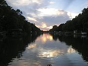
Otter Tail River
Encyclopedia
River
A river is a natural watercourse, usually freshwater, flowing towards an ocean, a lake, a sea, or another river. In a few cases, a river simply flows into the ground or dries up completely before reaching another body of water. Small rivers may also be called by several other names, including...
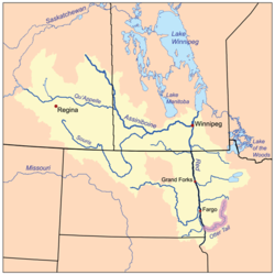
in the west-central portion of the U.S. state of Minnesota
Minnesota
Minnesota is a U.S. state located in the Midwestern United States. The twelfth largest state of the U.S., it is the twenty-first most populous, with 5.3 million residents. Minnesota was carved out of the eastern half of the Minnesota Territory and admitted to the Union as the thirty-second state...
. It begins in Clearwater County
Clearwater County, Minnesota
As of the census of 2000, there were 8,423 people, 3,330 households, and 2,287 families residing in the county. The population density was 8 people per square mile . There were 4,114 housing units at an average density of 4 per square mile...
, 40 miles (64.4 km) southwest of Bemidji
Bemidji, Minnesota
Bemidji is a city in Beltrami County, Minnesota, United States. Its population was at 13,431 at the 2010 census. It is the county seat of Beltrami County. Bemidji is the most major city in North Central Minnesota and the largest commercial center between Grand Forks, North Dakota and Duluth,...
. It then flows through a number of lakes and cities in Minnesota, including Elbow Lake, Many Point Lake, Chippewa Lake, Height of Land Lake, Frazee
Frazee, Minnesota
The United States Census Bureau estimated the population to be 1,385 in 2007. As of the census of 2000, there were 1,377 people, 504 households, and 318 families residing in the city. The population density was 1,593.2 people per square mile . There were 553 housing units at an average density of...
, the Pine lakes, Rush Lake, Otter Tail Lake
Otter Tail Lake
Otter Tail Lake is a lake in the west-central part of the U.S. state of Minnesota and is the largest lake in Otter Tail County.- Geography :Adjoining the city of Ottertail, it is a part of the Otter Tail River chain of lakes. Upstream from the lake are Big Pine, Little Pine and Rush lakes, while...
and Ottertail
Ottertail, Minnesota
Ottertail is a city in Otter Tail County, Minnesota, United States. The population was 572 at the 2010 census.-Geography:According to the United States Census Bureau, the city has a total area of , of which, of it is land and of it is water....
, West Lost Lake, Fergus Falls
Fergus Falls, Minnesota
Fergus Falls is a city in and the county seat of Otter Tail County, Minnesota, United States. The population was 13,138 at the 2010 census.-Today:...
, and Orwell Lake. At its mouth, it joins with the Bois de Sioux River
Bois de Sioux River
The Bois de Sioux River drains Lake Traverse, the southernmost body of water in the Hudson Bay watershed of North America. It is a tributary of the Red River of the North and defines part of the western border of the U.S. state of Minnesota, and the eastern borders of North Dakota and South Dakota...
to form the Red River
Red River of the North
The Red River is a North American river. Originating at the confluence of the Bois de Sioux and Otter Tail rivers in the United States, it flows northward through the Red River Valley and forms the border between the U.S. states of Minnesota and North Dakota before continuing into Manitoba, Canada...
at Wahpeton, North Dakota
Wahpeton, North Dakota
The first European explorer in the area was Jonathan Carver in 1767. He explored and mapped the Northwest at the request of Major Robert Rogers, commander of Fort Michilimackinac, the British fort at Mackinaw City, Michigan, which protected the passage between Lake Michigan and Lake Huron...
. The Red River is the Minnesota-North Dakota
North Dakota
North Dakota is a state located in the Midwestern region of the United States of America, along the Canadian border. The state is bordered by Canada to the north, Minnesota to the east, South Dakota to the south and Montana to the west. North Dakota is the 19th-largest state by area in the U.S....
boundary from this point onward to the Canadian border. Waters of the Red River watershed
Drainage basin
A drainage basin is an extent or an area of land where surface water from rain and melting snow or ice converges to a single point, usually the exit of the basin, where the waters join another waterbody, such as a river, lake, reservoir, estuary, wetland, sea, or ocean...
ultimately flow north into Hudson Bay
Hudson Bay
Hudson Bay , sometimes called Hudson's Bay, is a large body of saltwater in northeastern Canada. It drains a very large area, about , that includes parts of Ontario, Quebec, Saskatchewan, Alberta, most of Manitoba, southeastern Nunavut, as well as parts of North Dakota, South Dakota, Minnesota,...
.
Five dams were built on the Otter Tail River in the Fergus Falls area between 1909 and 1925 by the Otter Tail Power Company
Otter Tail Power Company
Otter Tail Corporation is an energy company based in Fergus Falls, Minnesota. Its main subsidiary is the Otter Tail Power Company.As of 2007, Otter Tail Power Company serves at least 423 towns at retail and delivers power to about 14 municipal utilities...
. They are Taplin Gorge (1925), Hoot Lake (1914), Central / Wright (1871 / 1922), Pisgah (1918), and Dayton Hollow (1909).