

Pole of inaccessibility
Encyclopedia
A pole of inaccessibility marks a location that is the most challenging to reach owing to its remoteness from geographical
features that could provide access. The term describes a geographic construct, not an actual physical phenomenon, and is of interest mostly to explorers.
pack ice at a distance farthest from any land mass. It is 661 km (411 statute miles) from the North Pole
, 1453 km (902.9 mi) north of Barrow, Alaska
, and equidistant from the closest landmasses, Ellesmere Island
and Franz-Josef Land, 1094 km (679.8 mi) away. It was first crossed by Sir Hubert Wilkins
, who flew by aircraft
in 1927; in 1958, a Russia
n icebreaker
reached this point. Owing to the constant motion of the pack ice, no permanent structure can exist at the pole.
According to some reports, the first person to reach the spot on foot was Sir Wally Herbert
, who arrived by dogsled in 1968. Other reports speak of this Pole as being still unconquered as of explorer Jim McNeill
's unsuccessful attempt in 2006. According to McNeill, Herbert did not quite make the Pole, whose position has also now been more accurately determined.
 The southern pole of inaccessibility is the point on the Antarctic continent most distant from the Southern Ocean
. A variety of different coordinate locations have been given for this pole. The discrepancies are due to the question of whether the "coast" is measured to the grounding line or to the edges of ice shelves, the difficulty of determining the location of the "solid" coastline, the movement of ice sheets and improvements in the accuracy of survey data over the years, as well as possible typographical errors. The pole of inaccessibility is commonly referred to the site of the Soviet Union research station mentioned below, which lies at 82°06′S 54°58′E (though some sources give 83°06′S 54°58′E). This lies 878 km (545 statute miles) from the South Pole
, at an elevation
of 3,718 m (12,198 ft). Using different criteria, the Scott Polar Research Institute
locates the pole at 85°50′S 65°47′E.
According to ThePoles.com, the point farthest from the sea accounting only for the Antarctic land surface proper is at 82°53′14"S 55°4′30"E, and the farthest point when ice sheets are taken into account is 83°50′37"S 65°43′30"E. These points, calculated by the British Antarctic Survey, are quoted as being "the most accurate measure available" (as of 2005).
The southern pole of inaccessibility is far more remote and difficult to reach than the geographic South Pole. On 14 December 1958, the 3rd Soviet Antarctic Expedition
for International Geophysical Year
research work, led by Yevgeny Tolstikov
, established the temporary Pole of Inaccessibility Station
(Polyus Nedostupnosti) at 82°06′S 54°58′E. A second Russian team returned there in 1967. Today, a building still remains at this location, marked by a bust of Vladimir Lenin
that faces towards Moscow
, and protected as a historical site. Inside the building, there is a golden visitors' book for those who make it to the site to sign.
On December 4, 2006, Team N2i, consisting of Henry Cookson
, Rupert Longsdon, Rory Sweet and Paul Landry
, embarked on an expedition to be the first to reach the historic pole of inaccessibility location without direct mechanical assistance, using a combination of traditional man hauling and kite skiing. The team reached the old abandoned station on 20 January 2007, re-discovering the forgotten statue of Lenin left there by the Soviets some 48 years previously. The explorers were picked up from the spot by a plane from Vostok
base to Progress and taken back to Cape Town on the Academic Federov, a Russian icebreaker. However, as of 2007, only the bust on top of the building is visible; the rest is buried under the snow.
On December 11, 2005, at 7:57 UTC, Ramón Larramendi, Juan Manuel Viu, and Ignacio Oficialdegui, members of the Spanish Transantarctic Expedition, reached for the first time in history the southern pole of inaccessibility at 82°53′14"S 55°04′30"E, updated that year by the British Antarctic Survey. The team continued their journey towards the second southern pole of inaccessibility, the one that accounts the ice shelves as well as the continental land, and they were the first expedition to reach it, on December 14, 2005, at 83°50′37"S 65°43′30"E. Both achievements took place within an ambitious pioneer crossing of the eastern Antarctic Plateau that started at Novolazerevskaya Base and ended at Progress Base after more than 4,500 km. This was the fastest polar journey ever achieved without mechanical aid, with an average rate of around 90 km/day and maximum 311 km/day, using kites as power source..
As mentioned above, due to improvements in technology and the position of the continental edge of Antarctica being debated, the exact position of our best estimate of the pole of inaccessibility may alter. However, for the convenience of sport expeditions, a fixed point is preferred, and the Soviet station has been used for this role. This has been recognised by the Guinness Book of Records in regard to Team N2i's expedition in 2006–2007.
(part of the Pitcairn Islands) in the north, Motu Nui
(part of the Easter Islands
) in the northeast, and Maher Island
(near the larger Siple Island
, off the coast of Marie Byrd Land
, Antarctica) in the south. Chatham Island lies farther west, and Southern Chile in the east. This location is also referred to as "Point Nemo", a reference to Jules Verne
's Captain Nemo
.
, the Continental Pole of Inaccessibility (46°17′N 86°40′E) is the place on land that is farthest from the ocean, and it lies in north-western China
, near the Kazakhstan
border. Earlier calculations suggested that it is 2645 km (1,643.5 mi) from the nearest coastline, located approximately 320 km (198.8 mi) north of the city of Ürümqi
, in the Xinjiang Autonomous Region
of China
, in the Dzoosotoyn Elisen Desert. The nearest settlements to this location are Hoxtolgay
at 46°34′N 85°58′E, about 30 miles (48.3 km) to the northwest, Xazgat at 46°20′N 86°22′E about 13 miles (20.9 km) to the west, and Suluk
at 46°15′N 86°50′E about 7 miles (11.3 km) to the east.
However, the previous pole location disregards the Gulf of Ob
as part of the oceans, and a recent study proposes two other locations as the ones farther from any ocean (within the uncertainty of coastline definition): EPIA1 44.29°N 82.19°E and EPIA2 45.28°N 88.14°E, located respectively at 2510±10 km and 2514±7 km from the oceans.
Coincidentally, the continental and oceanic poles of inaccessibility have a similar radius; the Eurasian poles EPIA1 and EPIA2 are ~178 km closer to the ocean than the oceanic pole is to land.
, the continental pole of inaccessibility is in southwest South Dakota
between Kyle
and Allen
, located 1650 km (1,025.3 mi) from the nearest coastline at 43.36°N 101.97°W.
, the continental pole of inaccessibility is in Brazil at 14.05°S 56.85°W, near Arenápolis
.
, the continental pole of inaccessibility is located either at 23.17°S 132.27°E or at 23°2′S 132°10′E, 920 km (571.7 mi) from the nearest coastline. The nearest town is Papunya
, Northern Territory
, about 30 km to the southwest.
, the pole of inaccessibility is at 5.65°N 26.17°E, 1814 km (1,127.2 mi) from the coast, close to the tripoint
of Central African Republic
, South Sudan
and Democratic Republic of the Congo
, also close to the town of Obo
.
Geography
Geography is the science that studies the lands, features, inhabitants, and phenomena of Earth. A literal translation would be "to describe or write about the Earth". The first person to use the word "geography" was Eratosthenes...
features that could provide access. The term describes a geographic construct, not an actual physical phenomenon, and is of interest mostly to explorers.
Northern pole of inaccessibility
The northern pole of inaccessibility (84°03′N 174°51′W), sometimes known as the Arctic pole of inaccessibility, or just Arctic pole, is located on the Arctic OceanArctic Ocean
The Arctic Ocean, located in the Northern Hemisphere and mostly in the Arctic north polar region, is the smallest and shallowest of the world's five major oceanic divisions...
pack ice at a distance farthest from any land mass. It is 661 km (411 statute miles) from the North Pole
North Pole
The North Pole, also known as the Geographic North Pole or Terrestrial North Pole, is, subject to the caveats explained below, defined as the point in the northern hemisphere where the Earth's axis of rotation meets its surface...
, 1453 km (902.9 mi) north of Barrow, Alaska
Barrow, Alaska
Barrow is the largest city of the North Slope Borough in the U.S. state of Alaska. It is one of the northernmost cities in the world and is the northernmost city in the United States of America, with nearby Point Barrow being the nation's northernmost point. Barrow's population was 4,212 at the...
, and equidistant from the closest landmasses, Ellesmere Island
Ellesmere Island
Ellesmere Island is part of the Qikiqtaaluk Region of the Canadian territory of Nunavut. Lying within the Canadian Arctic Archipelago, it is considered part of the Queen Elizabeth Islands, with Cape Columbia being the most northerly point of land in Canada...
and Franz-Josef Land, 1094 km (679.8 mi) away. It was first crossed by Sir Hubert Wilkins
Hubert Wilkins
Sir Hubert Wilkins MC & Bar was an Australian polar explorer, ornithologist, pilot, soldier, geographer and photographer.-Early life:...
, who flew by aircraft
Aircraft
An aircraft is a vehicle that is able to fly by gaining support from the air, or, in general, the atmosphere of a planet. An aircraft counters the force of gravity by using either static lift or by using the dynamic lift of an airfoil, or in a few cases the downward thrust from jet engines.Although...
in 1927; in 1958, a Russia
Russia
Russia or , officially known as both Russia and the Russian Federation , is a country in northern Eurasia. It is a federal semi-presidential republic, comprising 83 federal subjects...
n icebreaker
Icebreaker
An icebreaker is a special-purpose ship or boat designed to move and navigate through ice-covered waters. Although the term usually refers to ice-breaking ships, it may also refer to smaller vessels .For a ship to be considered an icebreaker, it requires three traits most...
reached this point. Owing to the constant motion of the pack ice, no permanent structure can exist at the pole.
According to some reports, the first person to reach the spot on foot was Sir Wally Herbert
Wally Herbert
Sir Walter William "Wally" Herbert was a British polar explorer, writer and artist. In 1969 he became the first man to walk undisputed to the North Pole, on the 60th anniversary of Robert Peary's famous, but disputed, expedition...
, who arrived by dogsled in 1968. Other reports speak of this Pole as being still unconquered as of explorer Jim McNeill
Jim McNeill, Polar Explorer
Jim McNeill McNeill is a polar explorer, presenter and keynote speaker, with over 25 years of experience travelling in the Arctic. He founded the Ice Warrior project in 2001. He has guided many groups to the Arctic, including BBC film crews...
's unsuccessful attempt in 2006. According to McNeill, Herbert did not quite make the Pole, whose position has also now been more accurately determined.
Southern pole of inaccessibility
Southern Ocean
The Southern Ocean comprises the southernmost waters of the World Ocean, generally taken to be south of 60°S latitude and encircling Antarctica. It is usually regarded as the fourth-largest of the five principal oceanic divisions...
. A variety of different coordinate locations have been given for this pole. The discrepancies are due to the question of whether the "coast" is measured to the grounding line or to the edges of ice shelves, the difficulty of determining the location of the "solid" coastline, the movement of ice sheets and improvements in the accuracy of survey data over the years, as well as possible typographical errors. The pole of inaccessibility is commonly referred to the site of the Soviet Union research station mentioned below, which lies at 82°06′S 54°58′E (though some sources give 83°06′S 54°58′E). This lies 878 km (545 statute miles) from the South Pole
South Pole
The South Pole, also known as the Geographic South Pole or Terrestrial South Pole, is one of the two points where the Earth's axis of rotation intersects its surface. It is the southernmost point on the surface of the Earth and lies on the opposite side of the Earth from the North Pole...
, at an elevation
Elevation
The elevation of a geographic location is its height above a fixed reference point, most commonly a reference geoid, a mathematical model of the Earth's sea level as an equipotential gravitational surface ....
of 3,718 m (12,198 ft). Using different criteria, the Scott Polar Research Institute
Scott Polar Research Institute
The Scott Polar Research Institute is a centre for research into the polar regions and glaciology worldwide. It is a sub-department of the Department of Geography in the University of Cambridge, located on Lensfield Road in the south of Cambridge ....
locates the pole at 85°50′S 65°47′E.
According to ThePoles.com, the point farthest from the sea accounting only for the Antarctic land surface proper is at 82°53′14"S 55°4′30"E, and the farthest point when ice sheets are taken into account is 83°50′37"S 65°43′30"E. These points, calculated by the British Antarctic Survey, are quoted as being "the most accurate measure available" (as of 2005).
The southern pole of inaccessibility is far more remote and difficult to reach than the geographic South Pole. On 14 December 1958, the 3rd Soviet Antarctic Expedition
3rd Soviet Antarctic Expedition
The Third Soviet Antarctic Expedition was led by Yevgeny Tolstikov on the continent; the marine expedition on the Ob was led by I V Maksimov....
for International Geophysical Year
International Geophysical Year
The International Geophysical Year was an international scientific project that lasted from July 1, 1957, to December 31, 1958. It marked the end of a long period during the Cold War when scientific interchange between East and West was seriously interrupted...
research work, led by Yevgeny Tolstikov
Yevgeny Tolstikov
Yevgeny Ivanovich Tolstikov was a Soviet polar explorer, awarded by the Hero of the Soviet Union title. He led the Third Soviet Antarctic Expedition and one of the first manned drifting ice station in the Arctic....
, established the temporary Pole of Inaccessibility Station
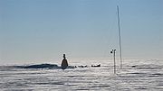
Pole of inaccessibility (Antarctic research station)
Pole of inaccessibility is a now defunct Soviet research station in Antarctica, located near the southern pole of inaccessibility — the point in Antarctica furthest from any ocean. . It performed meteorological observations from 14 December 1958 to 26 December 1958...
(Polyus Nedostupnosti) at 82°06′S 54°58′E. A second Russian team returned there in 1967. Today, a building still remains at this location, marked by a bust of Vladimir Lenin
Vladimir Lenin
Vladimir Ilyich Lenin was a Russian Marxist revolutionary and communist politician who led the October Revolution of 1917. As leader of the Bolsheviks, he headed the Soviet state during its initial years , as it fought to establish control of Russia in the Russian Civil War and worked to create a...
that faces towards Moscow
Moscow
Moscow is the capital, the most populous city, and the most populous federal subject of Russia. The city is a major political, economic, cultural, scientific, religious, financial, educational, and transportation centre of Russia and the continent...
, and protected as a historical site. Inside the building, there is a golden visitors' book for those who make it to the site to sign.
On December 4, 2006, Team N2i, consisting of Henry Cookson
Henry Cookson
Henry Cookson , FRGS, is a British polar explorer and adventurer. On 19 January 2007 he, alongside fellow Britons Rory Sweet and Rupert Longsdon, and their Canadian polar guide Paul Landry, became the first team to reach the southern Pole of Inaccessibility since a Soviet-led expedition in...
, Rupert Longsdon, Rory Sweet and Paul Landry
Paul Landry
Paul Landry M.B. is a French-Canadian polar explorer, author, and adventurer who is the only paid man to ever reach three Geographical poles in a single year....
, embarked on an expedition to be the first to reach the historic pole of inaccessibility location without direct mechanical assistance, using a combination of traditional man hauling and kite skiing. The team reached the old abandoned station on 20 January 2007, re-discovering the forgotten statue of Lenin left there by the Soviets some 48 years previously. The explorers were picked up from the spot by a plane from Vostok
Vostok Station
Vostok Station was a Russian Antarctic research station. It was at the southern Pole of Cold, with the lowest reliably measured natural temperature on Earth of −89.2 °C . Research includes ice core drilling and magnetometry...
base to Progress and taken back to Cape Town on the Academic Federov, a Russian icebreaker. However, as of 2007, only the bust on top of the building is visible; the rest is buried under the snow.
On December 11, 2005, at 7:57 UTC, Ramón Larramendi, Juan Manuel Viu, and Ignacio Oficialdegui, members of the Spanish Transantarctic Expedition, reached for the first time in history the southern pole of inaccessibility at 82°53′14"S 55°04′30"E, updated that year by the British Antarctic Survey. The team continued their journey towards the second southern pole of inaccessibility, the one that accounts the ice shelves as well as the continental land, and they were the first expedition to reach it, on December 14, 2005, at 83°50′37"S 65°43′30"E. Both achievements took place within an ambitious pioneer crossing of the eastern Antarctic Plateau that started at Novolazerevskaya Base and ended at Progress Base after more than 4,500 km. This was the fastest polar journey ever achieved without mechanical aid, with an average rate of around 90 km/day and maximum 311 km/day, using kites as power source..
As mentioned above, due to improvements in technology and the position of the continental edge of Antarctica being debated, the exact position of our best estimate of the pole of inaccessibility may alter. However, for the convenience of sport expeditions, a fixed point is preferred, and the Soviet station has been used for this role. This has been recognised by the Guinness Book of Records in regard to Team N2i's expedition in 2006–2007.
Oceanic pole of inaccessibility
The oceanic pole of inaccessibility (48°52.6′S 123°23.6′W) is the place in the ocean that is farthest from land. It lies in the South Pacific Ocean, 2688 kilometres (1,670.2 mi) from the nearest lands: Ducie IslandDucie Island
Ducie Island is an uninhabited atoll in the Pitcairn Islands. It lies east of Pitcairn and has a total area of , which includes the lagoon. It is long, measured northeast to southwest, and about wide. The island is composed of four islets: Acadia, Pandora, Westward and Edwards.Despite its...
(part of the Pitcairn Islands) in the north, Motu Nui
Motu Nui
Motu Nui is the largest of three islets just south of Easter Island and is the most westerly place in Chile. All three islets have sea birds but Motu Nui was also an essential location for the Tangata manu cult which was the island religion between the moai era and the Christian times...
(part of the Easter Islands
Easter Island
Easter Island is a Polynesian island in the southeastern Pacific Ocean, at the southeasternmost point of the Polynesian triangle. A special territory of Chile that was annexed in 1888, Easter Island is famous for its 887 extant monumental statues, called moai, created by the early Rapanui people...
) in the northeast, and Maher Island
Maher Island
Maher Island is a small horseshoe-shaped island which has numerous areas of exposed rock, lying 7 nautical miles north of the northwest end of Siple Island, off the coast of Marie Byrd Land. Discovered and photographed from aircraft of U.S. Navy Operation Highjump, 1946-47. Named by Advisory...
(near the larger Siple Island
Siple Island
Siple Island is a long snow-covered island lying east of Wrigley Gulf along the Getz Ice Shelf off Bakutis Coast of Marie Byrd Land, Antarctica...
, off the coast of Marie Byrd Land
Marie Byrd Land
Marie Byrd Land is the portion of West Antarctica lying east of the Ross Ice Shelf and the Ross Sea and south of the Pacific Ocean, extending eastward approximately to a line between the head of the Ross Ice Shelf and Eights Coast. It stretches between 158°W and 103°24'W...
, Antarctica) in the south. Chatham Island lies farther west, and Southern Chile in the east. This location is also referred to as "Point Nemo", a reference to Jules Verne
Jules Verne
Jules Gabriel Verne was a French author who pioneered the science fiction genre. He is best known for his novels Twenty Thousand Leagues Under the Sea , A Journey to the Center of the Earth , and Around the World in Eighty Days...
's Captain Nemo
Captain Nemo
Captain Nemo, also known as Prince Dakkar, is a fictional character featured in Jules Verne's novels Twenty Thousand Leagues Under the Sea and The Mysterious Island ....
.
Eurasia
In EurasiaEurasia
Eurasia is a continent or supercontinent comprising the traditional continents of Europe and Asia ; covering about 52,990,000 km2 or about 10.6% of the Earth's surface located primarily in the eastern and northern hemispheres...
, the Continental Pole of Inaccessibility (46°17′N 86°40′E) is the place on land that is farthest from the ocean, and it lies in north-western China
China
Chinese civilization may refer to:* China for more general discussion of the country.* Chinese culture* Greater China, the transnational community of ethnic Chinese.* History of China* Sinosphere, the area historically affected by Chinese culture...
, near the Kazakhstan
Kazakhstan
Kazakhstan , officially the Republic of Kazakhstan, is a transcontinental country in Central Asia and Eastern Europe. Ranked as the ninth largest country in the world, it is also the world's largest landlocked country; its territory of is greater than Western Europe...
border. Earlier calculations suggested that it is 2645 km (1,643.5 mi) from the nearest coastline, located approximately 320 km (198.8 mi) north of the city of Ürümqi
Ürümqi
Ürümqi , formerly Tihwa , is the capital of Xinjiang Uyghur Autonomous Region of the People's Republic of China, in the northwest of the country....
, in the Xinjiang Autonomous Region
Xinjiang
Xinjiang is an autonomous region of the People's Republic of China. It is the largest Chinese administrative division and spans over 1.6 million km2...
of China
China
Chinese civilization may refer to:* China for more general discussion of the country.* Chinese culture* Greater China, the transnational community of ethnic Chinese.* History of China* Sinosphere, the area historically affected by Chinese culture...
, in the Dzoosotoyn Elisen Desert. The nearest settlements to this location are Hoxtolgay
Hoxtolgay
Hoxtolgay or Heshituoluogai is a town in Hoboksar Mongol Autonomous County, Xinjiang Uygur Autonomous Region, PR China. It is located at , about 200 miles north of Ürümqi in the Dzungaria Basin...
at 46°34′N 85°58′E, about 30 miles (48.3 km) to the northwest, Xazgat at 46°20′N 86°22′E about 13 miles (20.9 km) to the west, and Suluk
Suluk
For the Suluk people of Sulu and Malaysia, see Tausūg people. For the Islamic or Sufi term, see Sulook. For the Libyan town, see Suluq.Suluk is a settlement in the Xinjiang Autonomous Region of China. It is situated 11 km to the east of the Continental Pole of inaccessibility, the point of...
at 46°15′N 86°50′E about 7 miles (11.3 km) to the east.
However, the previous pole location disregards the Gulf of Ob
Gulf of Ob
The Gulf of Ob is a gigantic bay of the Arctic Ocean, located in Northern Russia at the head the mouth of the Ob River....
as part of the oceans, and a recent study proposes two other locations as the ones farther from any ocean (within the uncertainty of coastline definition): EPIA1 44.29°N 82.19°E and EPIA2 45.28°N 88.14°E, located respectively at 2510±10 km and 2514±7 km from the oceans.
Coincidentally, the continental and oceanic poles of inaccessibility have a similar radius; the Eurasian poles EPIA1 and EPIA2 are ~178 km closer to the ocean than the oceanic pole is to land.
North America
In North AmericaNorth America
North America is a continent wholly within the Northern Hemisphere and almost wholly within the Western Hemisphere. It is also considered a northern subcontinent of the Americas...
, the continental pole of inaccessibility is in southwest South Dakota
South Dakota
South Dakota is a state located in the Midwestern region of the United States. It is named after the Lakota and Dakota Sioux American Indian tribes. Once a part of Dakota Territory, South Dakota became a state on November 2, 1889. The state has an area of and an estimated population of just over...
between Kyle
Kyle, South Dakota
Kyle is a census-designated place in Shannon County, South Dakota, United States. The population was 846 at the 2010 census...
and Allen
Allen, South Dakota
Allen is a census-designated place in Bennett County, South Dakota. As of the 2010 census, the CDP had a population of 420. It is considered the poorest place in the United States...
, located 1650 km (1,025.3 mi) from the nearest coastline at 43.36°N 101.97°W.
South America
In South AmericaSouth America
South America is a continent situated in the Western Hemisphere, mostly in the Southern Hemisphere, with a relatively small portion in the Northern Hemisphere. The continent is also considered a subcontinent of the Americas. It is bordered on the west by the Pacific Ocean and on the north and east...
, the continental pole of inaccessibility is in Brazil at 14.05°S 56.85°W, near Arenápolis
Arenápolis
Arenápolis is a town and municipality in the state of Mato Grosso in the Central-West Region of Brazil.-References:...
.
Australia
In AustraliaAustralia (continent)
Australia is the world's smallest continent, comprising the mainland of Australia and proximate islands including Tasmania, New Guinea, the Aru Islands and Raja Ampat Islands...
, the continental pole of inaccessibility is located either at 23.17°S 132.27°E or at 23°2′S 132°10′E, 920 km (571.7 mi) from the nearest coastline. The nearest town is Papunya
Papunya, Northern Territory
Papunya is a small Indigenous Australian community of about 299 people roughly 240 km northwest of Alice Springs in the Northern Territory, Australia...
, Northern Territory
Northern Territory
The Northern Territory is a federal territory of Australia, occupying much of the centre of the mainland continent, as well as the central northern regions...
, about 30 km to the southwest.
Africa
In AfricaAfrica
Africa is the world's second largest and second most populous continent, after Asia. At about 30.2 million km² including adjacent islands, it covers 6% of the Earth's total surface area and 20.4% of the total land area...
, the pole of inaccessibility is at 5.65°N 26.17°E, 1814 km (1,127.2 mi) from the coast, close to the tripoint
Tripoint
A tripoint, or trijunction , is a geographical point at which the borders of three countries or subnational entities meet....
of Central African Republic
Central African Republic
The Central African Republic , is a landlocked country in Central Africa. It borders Chad in the north, Sudan in the north east, South Sudan in the east, the Democratic Republic of the Congo and the Republic of the Congo in the south, and Cameroon in the west. The CAR covers a land area of about ,...
, South Sudan
South Sudan
South Sudan , officially the Republic of South Sudan, is a landlocked country located in the Sahel region of northeastern Africa. It is also part of the North Africa UN sub-region. Its current capital is Juba, which is also its largest city; the capital city is planned to be moved to the more...
and Democratic Republic of the Congo
Democratic Republic of the Congo
The Democratic Republic of the Congo is a state located in Central Africa. It is the second largest country in Africa by area and the eleventh largest in the world...
, also close to the town of Obo
Obo
Obo is the capital of Haut-Mbomou, one of the 14 prefectures of the Central African Republic. According to data used within Google Earth, the population is 12,787. It is close to the African Pole of Inaccessibility....
.
See also
- Pole of inaccessibility (Antarctic research station)Pole of inaccessibility (Antarctic research station)Pole of inaccessibility is a now defunct Soviet research station in Antarctica, located near the southern pole of inaccessibility — the point in Antarctica furthest from any ocean. . It performed meteorological observations from 14 December 1958 to 26 December 1958...
- Geographical poleGeographical poleA geographical pole is either of the two points—the north pole and the south pole—on the surface of a rotating planet where the axis of rotation meets the surface of the body...
- Extreme points of Earth
- Distance transformDistance transformA distance transform, also known as distance map or distance field, is a derived representation of a digital image. The choice of the term depends on the point of view on the object in question: whether the initial image is transformed into another representation, or it is simply endowed with an...