

Pico Blanco Scout Reservation
Encyclopedia
Pico Blanco Scout Reservation is a summer camp of about 800 acres (323.7 ha) (originally 1445 acres (584.8 ha)) in Central California, operated by the Monterey Bay Area Council of the Boy Scouts of America. Constructed during 1953-1954, it takes its name from the adjacent 3709 ft (1,130.5 m) Pico Blanco ("white peak"). The land was donated to the Council by William R. Hearst in 1948. It is the oldest Boy Scout camp on the California Central Coast
and celebrated its 50th anniversary in 2004.
Because the camp is surrounded by the Los Padres National Forest
and the Ventana Wilderness
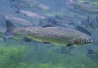
, the camp vicinity is an ecologically diverse and sensitive environment containing a number of unique animal and plant specimens, including the endangered
Southern Steelhead Trout
, the rare Santa Lucia fir, the California Coastal Redwood, and others. It is located at 800 feet (243.8 m) elevation on the pristine North Fork of the Little Sur River
, 11.3 miles (18.2 km) south of Carmel, California on Highway 1
, and eastward on Palo Calorado Road 7.6 miles (12.2 km) miles to Bottcher's Gap. The remaining 3.6 miles (5.8 km) miles of road into camp includes 2 miles (3.2 km) miles of narrow dirt road with four hair-pin switchbacks
. Historically, the camp area was visited regularly by the Esselen
American Indians, whose principal food source were acorns gathered from the Black Oak, Canyon Live Oak
and Tanbark Oak in the vicinity of the camp.
In 2002 the camp was impacted by a change in state regulations governing seasonal dams on California rivers. An inspector found fault with how they filled the dam and the National Oceanic and Atmospheric Administration
threatened to fine the council. The council responded by installing a USD $1 million fish ladder and other modifications that satisfied the regulators and allowed the council to continue to fill the dam.
The camp has been repeatedly threatened by fire, including the massive Basin Complex fire
of 2008, which was successfully kept at bay by fire fighters. The fire burned entirely around the camp, destroying the outlying ranger's residence. The council was forced to divert Scouts to another location for that summer.
. Camp activities include aquatics, shooting sports at three ranges, handicraft, nature study, Scoutcraft
skills (including a Skills Patrol area), a climbing and COPE course
. The camp offers an Adventure Day each Wednesday during camp season which gives Scouts access to a number of activities both in camp and out of camp. In 2007 the camp launched an older Scout program called Pico Pathfinders. The program consists of hiking, outdoor skills learning, shotgun shooting, knife/tomahawk throwing, and craft making.
Pico Blanco camp is the home of the Order of the Arrow Lodge Esselen 531. Order of the Arrow
, often referred to as OA, is a Boy Scouts of America National honorary society for campers and is dedicated to cheerful service. The camp also hosts the Council's one-week long National Youth Leadership Training program each summer.
During the first season of camp in 1954, the council offered seven six-day camp sessions from June 20 to August 7. Camp fees were USD
$2.50 per camper (or about $ in today's dollars) if the troop prepared its own meals, and USD $14.50 (or about $ in today's dollars) if the troop ate at the central kitchen. In 2009, the council offered three sessions for USD $315.00 per Scout.
into the Boy Scout camp, where 0.68 miles (1.1 km) above the camp it forks. The southern or left branch follows the Little Sur River to first, Fish Camp (formerly the border of the camp), and shortly afterward, Jackson Camp, about 1.5 miles (2.4 km) upstream. From Jackson Camp, there is a difficult, unmaintained and little-used route up Jackson Creek and overland to the Ventana Window. From the base of The Window, skilled climbers
can scale the very steep Class 4 eastern face of the Window. From the eastern top of the Window, it is possible to hike cross-country to the Ventana Doublecone, though the trail can be difficult due to the very dense ceanothus
.
Hikers who choose to follow the Little Sur River can leave Jackson Camp and follow a trail to Fox Camp, about 2 miles (3.2 km) farther. At Fox Camp, the Ventana Creek spills into the Little Sur River. From Fox Camp hikers can follow the course of the river upstream to the Little Sur River Gorge. Depending on the stream flow, hikers can reach three waterfalls and pools known locally as the Circular Pools. Each is progressively more difficult to get past.
The western or right fork of the trail in Pico Blanco Scout Reservation climbs Launtz Ridge 11 miles (17.7 km) to a fork in the trail, where hikers can take the right fork to Pico Blanco Campground, Pico Blanco camp itself, and the Coast Road, or veer left to 1.1 kilometre (0.683510010314787 mi) Launtz Creek Camp, Pfeiffer Big Sur State Park
and the coast 18 kilometres (11.2 mi) distant.
The Double Cone Trek was conceived in 1966 by Camp Director Chet Frisbie and Program Director Red Bryan. They sent three summer camp staff and Eagle Scouts—Bill Roberts, Terry Trotter, and Martin Woodward—to check out a multi-day hike around the camp. Roberts secured a measuring wheel from the Sierra Club. Trotter conducted nature surveys, noting the various flora and fauna at campsites, and took photographs. Woodward was tasked with noting all the campsite amenities or lack thereof, and all three brainstormed about the merit badges that might be worked on during the trek. The hike circles the Boy Scout camp, beginning at Bottcher's Gap, eastward around the Ventana Double Cone though Hiding Canyon and over the Pine Ridge Trail
, west over the Big Sur River
to Pfeiffer Big Sur State Park
, and then back east through Pico Blanco Public Camp to the Boy Scout camp. Portions of the last stretch of trail were so overgrown at the time that Roberts had to carry the measuring wheel.
Before camp started in 1967, Roberts took a contingent of the summer camp Scout craft staff on a training hike. George St.Clair led the first group to complete the hike that summer, and two more troops completed the trek that year. Camp sites, mileage points, and GPS coordinates are shown in the table. Each Scout who finishes the long hike is awarded the Double Cone Trek patch.
, funded by the Bing Crosby Pro-Am Invitational. Other facilities also constructed when the camp was first built include an administration building, Catholic Chapel, Presbyterian Chapel, quartermaster's building and trading post, health lodge, staff lodge, handicraft lodge, boat house, the original camp ranger's cabin, bridges, river fords
, electrical system, and twelve campsites. The Presbyterian Chapel was built around a cabin constructed by the Swetnam family in the 1890s. The Catholic Chapel has since been demolished. In the 1970s, the council erected a warehouse in the vicinity of the original rangers cabin, about 0.5 mile (0.80467 km) outside of the main camp. A new circular, glass enclosed ranger residence was built about 1 miles (1.6 km) outside of camp on a short ridge spur alongside the entrance road in the mid 1970s. The Staff Lodge was slightly damaged by a tree fall in the 1980s, and Council Camp Director Dean Crafton opted to demolish the building rather than repair it.
In 2003–2006, the council built the Hayward Lodge Dining Hall adjoining the Bing Crosby Kitchen. They also re-roofed the handicraft lodge which had suffered from severe water damage between the 2004 and 2005 camping seasons, installed a large flag pole near the Trading Post at Downtown Pico (The Parade Ground), and a second, smaller flag pole at Uptown Pico (the Staff Area). The new ranger's residence was destroyed in the 2008 Basin Complex fire
.
 The North Fork of the Little Sur River
, fed by several tributaries, passes through the camp. Because the river's watershed is entirely within the Ventana Wilderness
, the upstream area is in pristine condition. The river is a key habitat for endangered
Southern Steelhead Trout
." In 1973 the California State Legislature, recognizing the river's "extraordinary scenic, fishery, wildlife, (and) outdoor recreational values" and to protect its "free-flowing and wild status," added the river to the California Protected Waterways System. Responding to the state's request, in 1981 Monterey County added the river to its Protected Waterways Management Plan and encouraged the state in its Big Sur Coast Land Use Plan to designate the Little Sur area as a "coastal resource of national significance."
The Little Sur River watershed contains stands of some of the most impressive uncut Coastal Redwood trees in the entire Big Sur
area, including specimens over 200 feet (61 m) tall. It also contains the largest and tallest stands of Douglas Fir on the Central Coast, up to 150 feet (45.7 m) in height. A stand of the rare Santa Lucia fir, described as "the rarest and most unusual fir in North America," are found on Skinner's Ridge, east of the Scout camp. The North Fork of the Little Sur River supports the largest known population found on public lands of the rare Dudley’s lousewort
. Endemic to redwood forests, fewer than 10 known locations are known to support the plant.
, deer, fox, coyotes and wild boars. The area near the camp is populated with Coastal Redwood, Douglas Fir, Western Sycamore, Bay Laurel
, Bigleaf Maple, and Tanbark Oak. Mixed in with the Redwood and Douglas Fir is a riparian habitat
containing Alder
, poison oak
, and thimbleberry
. The upper slopes above camp in some areas are chaparral
, covered by coyote bush, ceanothus
, chamise, manzanita
, sagebrush
, and bush lupine. On a few upper slopes may be found patches of open grassland dotted with Black Oak, Canyon Live Oak
, and Tanbark Oak favored by the early Esselen
inhabitants.
The Little Sur River is considered by the California Department of Fish and Game to be the "most important spawning stream for steelhead" on the Central Coast. A fisheries service report estimates that the number of trout in the entire south-central coast area—including the Pajaro River
, Salinas River
, Carmel River
, Big Sur River
, and Little Sur River
—have dwindled from about 4,750 fish in 1965 to about 800 in 2005. The total number of steelhead in the Little Sur River was estimated at less than 100 in 1991.
Nearby Pico Blanco mountain, Spanish for "White Peak," is one of the most immediately recognizable peaks on the Central California coast
. The native Esselen people revered the peak as a sacred mountain from which all life originated. They believed that three creatures—the eagle, coyote and the hummingbird—rode out the Great Flood atop the mountain and went on to create the world. It bears a distinctive white limestone cap visible from California's Highway 1
. The limestone deposit is made up of two large, high-grade limestone bodies known as the Pico Blanco body and the Hayfield body. It is the only high-grade deposit on the Pacific Coast outside Alaska within three miles of potential marine transportation. Reserves have been estimated to be from 600 million to a billion tons, reportedly the largest in California, and the largest west of the Rocky Mountains
. The Granite Rock Company of Watsonville, California
bought the property and mineral rights to Pico Blanco in 1963. Limestone is a key ingredient in concrete and Granite Rock obtained a permit in 1983 from the U.S. Forest Service to dig a 5 acres (2 ha) open pit mine. The California Coastal Commission
intervened, requesting that the company also file for a permit with them. The deposit lies partly within and partly outside the national forest, complicating administration of the mining rights. The company refused to comply with the Commission's request and instead filed a lawsuit that eventually went all the way to the United States Supreme Court, where the mining plan was narrowly defeated. As of 2009, Granite Rock still owned the property.
and the Ventana Wilderness
, the camp has been endangered by fire several times. The Molera Fire in 1972 threatened the camp, and the U.S. Army dispatched 10 M-809 6x6
5-ton
troop carriers to the Pico Blanco Boy Scout Camp to evacuate the Scouts should it become necessary. In August, 1977, the Marble-Cone Fire
burned to the vicinity of the camp but did not destroy any buildings. In 2008, the Basin Complex fire
forced the Council to evacuate the camp. The fire eventually burned entirely around the camp, which was successfully defended by Red Truck Wildfire based in Boise, ID, assisted by a California Department of Forestry Hotshot crew
, CalFire, the Montana Department of Natural Resources and other crews. Only a portion of the water system piping and the outlying ranger's cabin were destroyed. Trees were also damaged throughout camp and loosened soil caused loose rock to fall on roads and hiking trails. The camp was closed and the campers were diverted to Boulder Creek Scout Reservation in Santa Cruz. The camp was reopened on June 20, 2009.
flash board dam on the Little Sur River
in 1955. When filled each summer, the dam creates a small recreational reservoir about 2 acre (0.809372 ha) in size.
Southern Steelhead trout
and required the state to inspect all recreational summer dams. In July 2001, Jonathan Ambrose, a fisheries service biologist, visited the camp and told camp officials that trout in the Little Sur River could be harmed if the dam provided insufficient flow downstream. In April 2002, the Council had only filed a partial application to fill the dam. The California Department of Fish and Game
told the Monterey Bay Area Council they could not fill the dam until the permit was complete, an environmental review was conducted, and a site visit was made.
, Vice-Chairman of the California State Senate Environmental Quality Committee, who called the head of Fish and Game, Robert Hight. On June 3, the Monterey County Herald ran a story titled, "Scouts' summer fun dries up." A Department of Fish and Game deputy director contacted the supervisor of the individual charged with enforcing the permit, and soon afterward Fish and Game changed its mind and allowed the council to fill the dam without the required permits.
On July 8, 2002, the camp staff began installing the flash boards to fill the dam. A fisheries service special agent videotaped the flash board installation and found the Council did not have the required water flow gauge installed and had not retained a biologist to assist with the installation. The camp staff initially indicated they would take a week to fill the dam, although an unnamed parent told the agent that the dam would be filled in one day, as usual. Two days later, in violation of the agreement with the National Marine Fisheries Service
, an unidentified camp staff member filled the 6 feet (1.8 m) deep dam in less than one day. The agent returned later in the day and found in the river bed below the dam 30 recently killed steelhead, stranded and suffocated. He reported that more were likely killed but had been eaten by raccoons and birds. The Assistant Council Executive commented, "Why the fish died is anybody's guess."
The agent observed that the knife gate—an opening at the base of the dam that was supposed to stay open to permit continued stream flow—was shut. The National Oceanic and Atmospheric Administration
, parent agency of the fisheries service, asked the Scouts to stop using the dam until they modified it to meet current standards and obtained the required permits. They told the Council it could face a fine of up USD $396,000 for violating the Endangered Species Act
. After intervention by Representative Sam Farr
, a recognized pro-environment legislator endorsed by the Sierra Club Political Committee, the Fisheries Service retreated from preventing the Scouts from operating the dam. Seven years after the fact, the San Francisco Chronicle
ran an article about the episode.
built.
The National Council of the Boy Scouts of America praised the Monterey Bay Area Council's success at getting the fish ladder constructed. "Additional donations from leaders in the construction industry to the Monterey Bay Area Council in 2006 also included the new Hayward Lodge and fish ladder at Camp Pico Blanco." Don Chapin, a long-time supporter of the Monterey Bay Area Council, was the honoree at a 2006 dinner cited as part of the campaign. The fish ladder is a unique design that had not been used in the United States beforehand. It was designed by Swanson Hydrology + Geomorphology and built by Don Chapin Company.
Environmental activists accused the council of using political pull to avoid the fines. McPherson and Farr confirmed that the Council requested that they contact regulators. Granite Construction, whose president David H. Watts is a member of the council board, gave USD $35,000 to McPherson. He also received USD $5,000 from Chapin Construction, headed by Donald Chapin. Rep. Sam Farr attended Pico Blanco Scout Reservation as a boy and his father Fred Farr contributed to the camp's development. When asked about the dam and its impact on the river, Farr stated that the dam has been there for almost 50 years. "The rules had changed and nobody knew what the rules would be," he said. "All the Boy Scouts asked is how to operate the dam properly." When asked about the influence of the USD $2000 campaign contribution he received from Granite Construction in 2006, he replied, "That's the analogy that I suggested was insulting. It was like somebody on the PTA gave Sam Farr a contribution."
American Indians who harvested acorns on the nearby mountain slopes. A large boulder with a dozen or more deep mortar bowls worn into it, known as a bedrock mortar
, is located in Apple Tree Camp on the southwest slope of Devil's Peak, north of the Pico Blanco Scout Reservation. The holes were hollowed out over many generations by Indians who used it to grind the acorns into flour. Other mortar rocks have also been found within the Boy Scout camp at campsites 3 and 7, and slightly upstream from campsite 12, while a fourth is found on a large rock in the river, originally above the river, between campsites 3 and 4. Much of the native Indian population had been forced into the Spanish mission system by about 1822, when most of the interior villages within the current Los Padres National Forest
were uninhabited.
When the Big Sur area became part of Mexico
along with the rest of California
and gained independence from Spain
in 1821, the Boy Scout camp area was on the border of Rancho San Jose y Sur Chiquito
land grant to the north and Rancho El Sur
to the south. After California
Other early homesteaders in the Palo Colorado Canyon region included Thomas W. Allen, 1891, Isaac N. Swetnam, 1894, Harry E. Morton, 1896, Samuel L. Trotter, 1901, Abijah C. Robbins, 1901, and Antare P. Lachance, 1904. Swetnam bought the Notley home at the mouth of Palo Colorado Canyon and also constructed a small cabin on the Little Sur River at the site of the future Pico Blanco camp. The original Protestant Chapel was built around the Swetnam cabin in 1955.
In October, 1905 the land that now makes up the Los Padres National Forest
, including the South Fork and portions of the upper reaches of the North Fork of the Little Sur River watershed, were withdrawn from public settlement by the United States Land Office, In January 1908, 39 sections
of land, totaling 25000 acres (10,117.2 ha), were added to the Monterey National Forest by President Theodore Roosevelt
in a presidential proclamation. This included five sections of land east and north of the current site of Pico Blanco Scout Reservation.
, the Monterey Bay Area Council was organized without camping facilities or suitable funds. In 1934, a makeshift Camp Wing was built within Big Sur State Park, but it was abandoned after the 1937 summer camping season. Camp Esselen was constructed the next year at another location within the Big Sur State Park. This site was improved until 1945, when limitations of the site, closeness to public camping facilities, and jurisdictional conflicts between the Scouts and the state forced the council to request reimbursement from the state for USD $8000 in improvements. The council continued to use the camp through August 1953. In 1952, construction was begun on Camp Pico Blanco, and in 1954 with the opening of Pico Blanco Scout Reservation, Camp Esselen was finally closed. The Pico Blanco Scout Reservation is the oldest Boy Scout camp on the California Central Coast
.
for USD $20,000. On September 9, 1948, Albert M. Lester of Carmel obtained a grant for the council of USD $20,000 from William Hearst through the Hearst Foundation
of New York City, offsetting the cost of the purchase. The council spent about USD $500,000 in improvements, including USD $200,000 to build a 8 miles (12.9 km) road into the camp area. In 1963 the Council Executive estimated that buying the land at that time would cost the council over USD $1 million, or nearly $ in today's dollars. Road construction was begun in 1950 by the United States Army Corps of Engineers
from a local area on Palo Colorado Road known as "The Hoist" to Bottcher's Gap (2050 feet (624.8 m)), the site of former homesteader John Bottcher's cabin in 1885-86. The road was later turned over to Monterey County. The remaining 3.7 miles (6 km) miles of road into camp includes 2 miles (3.2 km) miles of narrow dirt road with four hair-pin switchbacks
.
In the 1960s, another piece of land in the vicinity of Dani Ridge on the northeast slope of Pico Blanco, totaling 80 acres (32.4 ha), was donated to the council. This steeply sloped piece of property included Redwood trees up to 11 feet (3.4 m) in diameter and raised the total acreage to 1525 acres (617.1 ha). The original camp property extended about 2 miles (3.2 km) southward along the Little Sur River, almost to Fish Camp, just short of Jackson Camp.
The Council sold 245 acres (99.1 ha) to the federal government for about USD $100,000 shortly after the 1977 Marble Cone fire. It later sold about 525 acres (212.5 ha) in the 1980s to the federal government for an unknown amount, reducing the camp to its present size of about 800 acres (323.7 ha). In 1990, the Monterey Bay Area Council executive board voted to sell the entire camp, resulting in considerable controversy and opposition. No buyer was found, and in 1992, the executive board voted in closed session to sell half of the camp property for $3 million, but once again no offers were received.
and White Stag Leadership Development Program
, acknowledging the important part both programs have played in the history of the camp.
was named for the native Esselen
American Indian tribe who first inhabited the area. The lodge was organized in the council on November 23, 1957 by George Ross, Ray Sutliff—who designed the lodge patch—and a third man whose last name was Alcorn. George Ross was also the first Lodge Adviser and first adult Vigil recipient in Esselen Lodge. In 1972-73, Lodge Chief Tom Quarterero built a sign for the camp at the mouth of Palo Colorado Road on Highway 1. The Lodge has supported camping in the council by writing and publishing the Where to go Camping booklet for many years. It has also produced slide shows promoting the camp. Lodge members and leaders have repeatedly served on camp staff for many years.
Bill Lidderdale, a district executive in the Monterey Bay Area Council during the 1960s, was the Esselen Lodge staff adviser for several years. Chief Scout Executive Robert Mazzuca, formerly a member of Troop 428 in San Juan Bautista
, credited Lidderdale as the reason he became a Scout executive. "I just worshiped this guy. He was my hero. He told me about professional Scouting and said he thought I would do a good job." Mazzuca later achieved the Brotherhood Honor as a member of Esselen Lodge during the 1960s and served on Pico Blanco camp staff for two summers. The Lodge observed its 50th Ordeal at Pico Blanco camp from August 17–19, 2007.
experimented with the idea of training boys in leadership skills during a week of summer camp at Pico Blanco Scout Reservation. The Council actively supported his experiment. Assistant Scout Executive, Esselen Lodge Staff Adviser, and Camp Director Bill Lidderdale served as staff advisor to the White Stag Leadership Development Program
that Bánáthy founded. The council's program was so successful that it drew attention from the National Council of the Boy Scouts of America. In 1964, National BSA executives, volunteers, and board members attended a meeting at the Asilomar Conference Grounds
in Pacific Grove
, California. As a result of this meeting, the National Council began a thorough study of the Monterey Bay Area Council's program.
Up to this point, junior leaders training had been focused on Scoutcraft
skills and use of the Patrol Method. The National Council concluded that offering leadership development to youth was a unique opportunity for Scouting to provide a practical benefit to youth and would add substantial support to Scouting's character development goals. By the end of 1974, both the adult Wood Badge
and junior leader training
had undergone fundamental shifts, focusing on teaching specific leadership skills instead of Scoutcraft, outdoor living skills, and the Patrol Method. National council professional staff visited the council and Pico Blanco Scout Reservation several times to view the White Stag program in action and to evaluate the council program's success.
In 1975, volunteer Scouters leading the White Stag program invited Explorer-age girls 14 years of age or older to take part in the program. In the next few years, Girl Scouts
were also invited. In 1978, the Monterey Bay Area Council Executive decided they were uncomfortable with a coed program and refused to allow the volunteer Scouters to rent Pico Blanco Scout Reservation the next summer. The White Stag program was held for the next 17 years at various camps in Northern California. In 1994, Council Training Chairman Steve Cardinalli approached the Council Executive with the idea of allowing local White Stag alumni and volunteer Scouters to run both the official National Youth Leadership Training
(NYLT) and a White Stag program at the camp. The council embraced the program once again until 2005 when a new Council Executive decided the Council would only offer the nationally sanctioned NYLT program. The Monterey-area Scout volunteers incorporated the non-profit White Stag Academy to administer the program locally. The leadership program continues to sponsor a Boy Scout troop and a Venturing Crew in the Monterey Council, and is headquartered at the Paul Sujan Scout Lodge on the Presidio of Monterey, California. Summer camp is usually held in the nearby Santa Cruz Mountains
. As of 2011 the program had taught leadership skills to approximately 20,500 largely Monterey County youth. A second organization, the White Stag Association, continues to sponsor a smaller summer camp program in the San Francisco East Bay. Its camp is usually held at Scout camps in the Sierra Nevada mountains.
Central Coast of California
The Central Coast is an area of California, United States, roughly spanning the area between the Monterey Bay and Point Conception. It extends through Santa Cruz County, San Benito County, Monterey County, San Luis Obispo County, and Santa Barbara County...
and celebrated its 50th anniversary in 2004.
Because the camp is surrounded by the Los Padres National Forest
Los Padres National Forest
Los Padres National Forest is a forest located in southern and central California, which includes most of the mountainous land along the California coast from Ventura to Monterey, extending inland...
and the Ventana Wilderness
Ventana Wilderness
The Ventana Wilderness of Los Padres National Forest is a Federally designated wilderness area located in the Santa Lucia Mountains along the Central Coast of California. This wilderness was established in 1969 when the Ventana Wilderness Act abolished the Ventana Primitive Area and replaced it...
, the camp vicinity is an ecologically diverse and sensitive environment containing a number of unique animal and plant specimens, including the endangered
Endangered species
An endangered species is a population of organisms which is at risk of becoming extinct because it is either few in numbers, or threatened by changing environmental or predation parameters...
Southern Steelhead Trout
Rainbow trout
The rainbow trout is a species of salmonid native to tributaries of the Pacific Ocean in Asia and North America. The steelhead is a sea run rainbow trout usually returning to freshwater to spawn after 2 to 3 years at sea. In other words, rainbow trout and steelhead trout are the same species....
, the rare Santa Lucia fir, the California Coastal Redwood, and others. It is located at 800 feet (243.8 m) elevation on the pristine North Fork of the Little Sur River
Little Sur River
The Little Sur River is on the Central Coast of California. The river drains a portion of the Big Sur area, a thinly settled region of the Central California coast where the Santa Lucia Mountains rise abruptly from the Pacific Ocean...
, 11.3 miles (18.2 km) south of Carmel, California on Highway 1
California State Route 1
State Route 1 , more often called Highway 1, is a state highway that runs along much of the Pacific coast of the U.S. state of California. It is famous for running along some of the most beautiful coastlines in the world, leading to its designation as an All-American Road.Highway 1 does not run...
, and eastward on Palo Calorado Road 7.6 miles (12.2 km) miles to Bottcher's Gap. The remaining 3.6 miles (5.8 km) miles of road into camp includes 2 miles (3.2 km) miles of narrow dirt road with four hair-pin switchbacks
Hairpin turn
A hairpin turn , named for its resemblance to a hairpin/bobby pin, is a bend in a road with a very acute inner angle, making it necessary for an oncoming vehicle to turn almost 180° to continue on the road. Such turns in ramps and trails may be called switchbacks in American English, by analogy...
. Historically, the camp area was visited regularly by the Esselen
Esselen
The Esselen were a Native American linguistic group in the hypothetical Hokan language family, who resided on the Central California coast and the coastal mountains, including what is now known as the Big Sur region in Monterey County, California...
American Indians, whose principal food source were acorns gathered from the Black Oak, Canyon Live Oak
Quercus chrysolepis
Quercus chrysolepis, commonly termed Canyon Live Oak, or Golden Cup Oak, is a species of evergreen oak that is found in the southwestern part of North America, notably in the California Coast Ranges. This tree is often found near creeks and drainage swales growing in moist cool microhabitats...
and Tanbark Oak in the vicinity of the camp.
In 2002 the camp was impacted by a change in state regulations governing seasonal dams on California rivers. An inspector found fault with how they filled the dam and the National Oceanic and Atmospheric Administration
National Oceanic and Atmospheric Administration
The National Oceanic and Atmospheric Administration , pronounced , like "noah", is a scientific agency within the United States Department of Commerce focused on the conditions of the oceans and the atmosphere...
threatened to fine the council. The council responded by installing a USD $1 million fish ladder and other modifications that satisfied the regulators and allowed the council to continue to fill the dam.
The camp has been repeatedly threatened by fire, including the massive Basin Complex fire
Summer 2008 California wildfires
The summer 2008 California wildfires, collectively dubbed the Northern California Lightning Series by CAL FIRE, were a concentrated outbreak of wildfires during the summer of 2008. Over 2,780 individual fires were burning at the height of the period, burning large portions of forests and chaparral...
of 2008, which was successfully kept at bay by fire fighters. The fire burned entirely around the camp, destroying the outlying ranger's residence. The council was forced to divert Scouts to another location for that summer.
Activities
The dominant features of the camp are the Coastal Redwood and the North Fork of the Little Sur RiverLittle Sur River
The Little Sur River is on the Central Coast of California. The river drains a portion of the Big Sur area, a thinly settled region of the Central California coast where the Santa Lucia Mountains rise abruptly from the Pacific Ocean...
. Camp activities include aquatics, shooting sports at three ranges, handicraft, nature study, Scoutcraft
Scoutcraft
Scoutcraft is a term used to cover a variety of woodcraft knowledge and skills required by people seeking to venture into wild country and sustain themselves independently. The term has been adopted by Scouting organizations to reflect skills and knowledge which are felt to be a core part of the...
skills (including a Skills Patrol area), a climbing and COPE course
Ropes course
A ropes course is a challenging outdoor personal development and team building activity which usually consists of high and/or low elements. Low elements take place on the ground or only a few feet above the ground...
. The camp offers an Adventure Day each Wednesday during camp season which gives Scouts access to a number of activities both in camp and out of camp. In 2007 the camp launched an older Scout program called Pico Pathfinders. The program consists of hiking, outdoor skills learning, shotgun shooting, knife/tomahawk throwing, and craft making.
Pico Blanco camp is the home of the Order of the Arrow Lodge Esselen 531. Order of the Arrow
Order of the Arrow
The Order of the Arrow is the national honor society of the Boy Scouts of America . It uses American Indian-styled traditions and ceremonies to bestow recognition on scouts selected by their peers as best exemplifying the ideals of Scouting. The society was created by E. Urner Goodman, with the...
, often referred to as OA, is a Boy Scouts of America National honorary society for campers and is dedicated to cheerful service. The camp also hosts the Council's one-week long National Youth Leadership Training program each summer.
During the first season of camp in 1954, the council offered seven six-day camp sessions from June 20 to August 7. Camp fees were USD
United States dollar
The United States dollar , also referred to as the American dollar, is the official currency of the United States of America. It is divided into 100 smaller units called cents or pennies....
$2.50 per camper (or about $ in today's dollars) if the troop prepared its own meals, and USD $14.50 (or about $ in today's dollars) if the troop ate at the central kitchen. In 2009, the council offered three sessions for USD $315.00 per Scout.
Area hiking and camping
Beginning at Botcher's Gap, the road into the camp is not open to private vehicles. Hikers can follow a National Forest trail down the camp road until it leaves the road for the Little Sur River Camp. The trail then follows the Little Sur RiverLittle Sur River
The Little Sur River is on the Central Coast of California. The river drains a portion of the Big Sur area, a thinly settled region of the Central California coast where the Santa Lucia Mountains rise abruptly from the Pacific Ocean...
into the Boy Scout camp, where 0.68 miles (1.1 km) above the camp it forks. The southern or left branch follows the Little Sur River to first, Fish Camp (formerly the border of the camp), and shortly afterward, Jackson Camp, about 1.5 miles (2.4 km) upstream. From Jackson Camp, there is a difficult, unmaintained and little-used route up Jackson Creek and overland to the Ventana Window. From the base of The Window, skilled climbers
Mountaineering
Mountaineering or mountain climbing is the sport, hobby or profession of hiking, skiing, and climbing mountains. While mountaineering began as attempts to reach the highest point of unclimbed mountains it has branched into specialisations that address different aspects of the mountain and consists...
can scale the very steep Class 4 eastern face of the Window. From the eastern top of the Window, it is possible to hike cross-country to the Ventana Doublecone, though the trail can be difficult due to the very dense ceanothus
Ceanothus
Ceanothus L. is a genus of about 50–60 species of shrubs or small trees in the buckthorn family Rhamnaceae. The genus is confined to North America, the center of its distribution in California, with some species in the eastern United States and southeast Canada, and others extending as far south...
.
Hikers who choose to follow the Little Sur River can leave Jackson Camp and follow a trail to Fox Camp, about 2 miles (3.2 km) farther. At Fox Camp, the Ventana Creek spills into the Little Sur River. From Fox Camp hikers can follow the course of the river upstream to the Little Sur River Gorge. Depending on the stream flow, hikers can reach three waterfalls and pools known locally as the Circular Pools. Each is progressively more difficult to get past.
The western or right fork of the trail in Pico Blanco Scout Reservation climbs Launtz Ridge 11 miles (17.7 km) to a fork in the trail, where hikers can take the right fork to Pico Blanco Campground, Pico Blanco camp itself, and the Coast Road, or veer left to 1.1 kilometre (0.683510010314787 mi) Launtz Creek Camp, Pfeiffer Big Sur State Park
Pfeiffer Big Sur State Park
Pfeiffer Big Sur State Park is a state park in Monterey County, California near the town of Big Sur on the state's Central Coast. It covers approximately of land. The park is centered around the Big Sur River. It has been nicknamed a "mini Yosemite."...
and the coast 18 kilometres (11.2 mi) distant.
Double Cone Trek
| Campground / Feature | Mileage | Elevation | Coordinates |
| Botcher's Gap | 0 mile (0 km) | 2060 feet (627.9 m) | 36.35385°N 121.81356°W |
| Devil's Peak Ridge | 3.8 miles (6.1 km) | 4075 feet (1,242.1 m) | 36.3674°N 121.7867°W |
| Pat Springs | 8 miles (12.9 km) | 3820 feet (1,164.3 m) | 36.36330°N 121.74412°W |
| Little Pines | 10 miles (16.1 km) | 4153 feet (1,265.8 m) | 36.35274°N 121.72384°W |
| Double Cone summit † | 15 miles (24.1 km) | 4853 feet (1,479.2 m) | 36.29691°N 121.71467°W |
| Hiding Canyon | 14.5 miles (23.3 km) | 1743 feet (531.3 m) | 36.32135°N 121.68550°W |
| Pine Valley | 20 miles (32.2 km) | 3141 feet (957.4 m) | 36.30107°N 121.63550°W |
| Pine Ridge | 24 miles (38.6 km) | 4180 feet (1,274.1 m) | 36.27357°N 121.65050°W |
| Redwood Camp | 28.8 miles (46.3 km) | 1800 feet (548.6 m) | 36.25496°N 121.66939°W |
| Sykes Hot Springs | 30.3 miles (48.8 km) | 1259 feet (383.7 m) | 36.24857°N 121.68550°W |
| Barlow Flats | 32.9 miles (52.9 km) | 900 feet (274.3 m) | 36.24691°N 121.71273°W |
| Terrace Creek | 36 miles (57.9 km) | 1350 feet (411.5 m) | 36.24635°N 121.72912°W |
| Pfeiffer Big Sur State Park | 41 miles (66 km) | 375 feet (114.3 m) | 36.09443°N 121.61913°W |
| Manual Peak summit | 47 miles (75.6 km) | 1686 feet (513.9 m) | 36.27413°N 121.77079°W |
| Tin Shack | 50 miles (80.5 km) | 2100 feet (640.1 m) | 36.28889°N 121.75667°W |
| Pico Blanco summit † | 51.5 miles (82.9 km) | 3709 feet (1,130.5 m) | 36.31885°N 121.81134°W |
| Vado Camp | 53 miles (85.3 km) | 1700 feet (518.2 m) | 36.30413°N 121.78868°W |
| Launtz Creek | 55.2 miles (88.8 km) | 1640 feet (499.9 m) | 36.30941°N 121.79190°W |
| Pico Blanco Scout Reservation | 60.2 miles (96.9 km) | 793 feet (241.7 m) | 36.33191°N 121.79718°W |
† Optional side-trip. Mileage not included in trek total. |
|||
The Double Cone Trek was conceived in 1966 by Camp Director Chet Frisbie and Program Director Red Bryan. They sent three summer camp staff and Eagle Scouts—Bill Roberts, Terry Trotter, and Martin Woodward—to check out a multi-day hike around the camp. Roberts secured a measuring wheel from the Sierra Club. Trotter conducted nature surveys, noting the various flora and fauna at campsites, and took photographs. Woodward was tasked with noting all the campsite amenities or lack thereof, and all three brainstormed about the merit badges that might be worked on during the trek. The hike circles the Boy Scout camp, beginning at Bottcher's Gap, eastward around the Ventana Double Cone though Hiding Canyon and over the Pine Ridge Trail
Pine Ridge Trail
The Pine Ridge Trail is a popular hiking route in the Ventana Wilderness of the Los Padres National Forest. It can be hiked both ways, but the consensus route is China Camp to Big Sur Station since that is the downhill direction.-Trail Guide:...
, west over the Big Sur River
Big Sur River
The Big Sur River is a river on the Central Coast of California. The river drains a portion of the Big Sur area, a thinly settled region of the Central California coast where the Santa Lucia Mountains rise abruptly from the Pacific Ocean...
to Pfeiffer Big Sur State Park
Pfeiffer Big Sur State Park
Pfeiffer Big Sur State Park is a state park in Monterey County, California near the town of Big Sur on the state's Central Coast. It covers approximately of land. The park is centered around the Big Sur River. It has been nicknamed a "mini Yosemite."...
, and then back east through Pico Blanco Public Camp to the Boy Scout camp. Portions of the last stretch of trail were so overgrown at the time that Roberts had to carry the measuring wheel.
Before camp started in 1967, Roberts took a contingent of the summer camp Scout craft staff on a training hike. George St.Clair led the first group to complete the hike that summer, and two more troops completed the trek that year. Camp sites, mileage points, and GPS coordinates are shown in the table. Each Scout who finishes the long hike is awarded the Double Cone Trek patch.
Facilities
Original facilities included the Bing Crosby Kitchen built with money donated by the Bing Crosby FundBing Crosby
Harry Lillis "Bing" Crosby was an American singer and actor. Crosby's trademark bass-baritone voice made him one of the best-selling recording artists of the 20th century, with over half a billion records in circulation....
, funded by the Bing Crosby Pro-Am Invitational. Other facilities also constructed when the camp was first built include an administration building, Catholic Chapel, Presbyterian Chapel, quartermaster's building and trading post, health lodge, staff lodge, handicraft lodge, boat house, the original camp ranger's cabin, bridges, river fords
Ford (crossing)
A ford is a shallow place with good footing where a river or stream may be crossed by wading or in a vehicle. A ford is mostly a natural phenomenon, in contrast to a low water crossing, which is an artificial bridge that allows crossing a river or stream when water is low.The names of many towns...
, electrical system, and twelve campsites. The Presbyterian Chapel was built around a cabin constructed by the Swetnam family in the 1890s. The Catholic Chapel has since been demolished. In the 1970s, the council erected a warehouse in the vicinity of the original rangers cabin, about 0.5 mile (0.80467 km) outside of the main camp. A new circular, glass enclosed ranger residence was built about 1 miles (1.6 km) outside of camp on a short ridge spur alongside the entrance road in the mid 1970s. The Staff Lodge was slightly damaged by a tree fall in the 1980s, and Council Camp Director Dean Crafton opted to demolish the building rather than repair it.
In 2003–2006, the council built the Hayward Lodge Dining Hall adjoining the Bing Crosby Kitchen. They also re-roofed the handicraft lodge which had suffered from severe water damage between the 2004 and 2005 camping seasons, installed a large flag pole near the Trading Post at Downtown Pico (The Parade Ground), and a second, smaller flag pole at Uptown Pico (the Staff Area). The new ranger's residence was destroyed in the 2008 Basin Complex fire
Summer 2008 California wildfires
The summer 2008 California wildfires, collectively dubbed the Northern California Lightning Series by CAL FIRE, were a concentrated outbreak of wildfires during the summer of 2008. Over 2,780 individual fires were burning at the height of the period, burning large portions of forests and chaparral...
.
Little Sur River watershed
Little Sur River
The Little Sur River is on the Central Coast of California. The river drains a portion of the Big Sur area, a thinly settled region of the Central California coast where the Santa Lucia Mountains rise abruptly from the Pacific Ocean...
, fed by several tributaries, passes through the camp. Because the river's watershed is entirely within the Ventana Wilderness
Ventana Wilderness
The Ventana Wilderness of Los Padres National Forest is a Federally designated wilderness area located in the Santa Lucia Mountains along the Central Coast of California. This wilderness was established in 1969 when the Ventana Wilderness Act abolished the Ventana Primitive Area and replaced it...
, the upstream area is in pristine condition. The river is a key habitat for endangered
Endangered species
An endangered species is a population of organisms which is at risk of becoming extinct because it is either few in numbers, or threatened by changing environmental or predation parameters...
Southern Steelhead Trout
Rainbow trout
The rainbow trout is a species of salmonid native to tributaries of the Pacific Ocean in Asia and North America. The steelhead is a sea run rainbow trout usually returning to freshwater to spawn after 2 to 3 years at sea. In other words, rainbow trout and steelhead trout are the same species....
." In 1973 the California State Legislature, recognizing the river's "extraordinary scenic, fishery, wildlife, (and) outdoor recreational values" and to protect its "free-flowing and wild status," added the river to the California Protected Waterways System. Responding to the state's request, in 1981 Monterey County added the river to its Protected Waterways Management Plan and encouraged the state in its Big Sur Coast Land Use Plan to designate the Little Sur area as a "coastal resource of national significance."
The Little Sur River watershed contains stands of some of the most impressive uncut Coastal Redwood trees in the entire Big Sur
Big Sur
Big Sur is a sparsely populated region of the Central Coast of California where the Santa Lucia Mountains rise abruptly from the Pacific Ocean. The name "Big Sur" is derived from the original Spanish-language "el sur grande", meaning "the big south", or from "el país grande del sur", "the big...
area, including specimens over 200 feet (61 m) tall. It also contains the largest and tallest stands of Douglas Fir on the Central Coast, up to 150 feet (45.7 m) in height. A stand of the rare Santa Lucia fir, described as "the rarest and most unusual fir in North America," are found on Skinner's Ridge, east of the Scout camp. The North Fork of the Little Sur River supports the largest known population found on public lands of the rare Dudley’s lousewort
Pedicularis dudleyi
Pedicularis dudleyi is a rare species of flowering plant in the broomrape family known by the common name Dudley's lousewort. It is endemic to central California, where it is known from about ten scattered occurrences along the coast and in the coastal mountain ranges. It is a resident of forest...
. Endemic to redwood forests, fewer than 10 known locations are known to support the plant.
River gorge wildlife and vegetation
Wildlife in the Little Sur River watershed include the mountain lion, bearAmerican black bear
The American black bear is a medium-sized bear native to North America. It is the continent's smallest and most common bear species. Black bears are omnivores, with their diets varying greatly depending on season and location. They typically live in largely forested areas, but do leave forests in...
, deer, fox, coyotes and wild boars. The area near the camp is populated with Coastal Redwood, Douglas Fir, Western Sycamore, Bay Laurel
Bay Laurel
The bay laurel , also known as sweet bay, bay tree, true laurel, Grecian laurel, laurel tree, or simply laurel, is an aromatic evergreen tree or large shrub with green, glossy leaves, native to the Mediterranean region. It is the source of the bay leaf used in cooking...
, Bigleaf Maple, and Tanbark Oak. Mixed in with the Redwood and Douglas Fir is a riparian habitat
Riparian zone
A riparian zone or riparian area is the interface between land and a river or stream. Riparian is also the proper nomenclature for one of the fifteen terrestrial biomes of the earth. Plant habitats and communities along the river margins and banks are called riparian vegetation, characterized by...
containing Alder
Alder
Alder is the common name of a genus of flowering plants belonging to the birch family . The genus comprises about 30 species of monoecious trees and shrubs, few reaching large size, distributed throughout the North Temperate Zone and in the Americas along the Andes southwards to...
, poison oak
Poison oak
Poison oak may refer to* Toxicodendron diversilobum, grows on West Coast of North America* Toxicodendron pubescens, grows in the Eastern United Statesdamnnnnn tissss is terribleee...
, and thimbleberry
Thimbleberry
Rubus parviflorus, commonly called thimbleberry or salmonberry, is a species of Rubus, native to western and northern North America, from Alaska east to Ontario and Michigan, and south to northern Mexico...
. The upper slopes above camp in some areas are chaparral
Chaparral
Chaparral is a shrubland or heathland plant community found primarily in the U.S. state of California and in the northern portion of the Baja California peninsula, Mexico...
, covered by coyote bush, ceanothus
Ceanothus
Ceanothus L. is a genus of about 50–60 species of shrubs or small trees in the buckthorn family Rhamnaceae. The genus is confined to North America, the center of its distribution in California, with some species in the eastern United States and southeast Canada, and others extending as far south...
, chamise, manzanita
Manzanita
Manzanita is a common name for many species of the genus Arctostaphylos. They are evergreen shrubs or small trees present in the chaparral biome of western North America, where they occur from southern British Columbia, Washington to California, Arizona and New Mexico in the United States, and...
, sagebrush
Sagebrush
Sagebrush is a common name of a number of shrubby plant species in the genus Artemisia native to western North America;Or, the sagebrush steppe ecoregion, having one or more kinds of sagebrush, bunchgrasses and others;...
, and bush lupine. On a few upper slopes may be found patches of open grassland dotted with Black Oak, Canyon Live Oak
Quercus chrysolepis
Quercus chrysolepis, commonly termed Canyon Live Oak, or Golden Cup Oak, is a species of evergreen oak that is found in the southwestern part of North America, notably in the California Coast Ranges. This tree is often found near creeks and drainage swales growing in moist cool microhabitats...
, and Tanbark Oak favored by the early Esselen
Esselen
The Esselen were a Native American linguistic group in the hypothetical Hokan language family, who resided on the Central California coast and the coastal mountains, including what is now known as the Big Sur region in Monterey County, California...
inhabitants.
The Little Sur River is considered by the California Department of Fish and Game to be the "most important spawning stream for steelhead" on the Central Coast. A fisheries service report estimates that the number of trout in the entire south-central coast area—including the Pajaro River
Pajaro River
The Pajaro River is a river in Northern California, forming part of the border between Santa Cruz County and Monterey County and between San Benito County and Santa Clara County.-History:...
, Salinas River
Salinas River (California)
The Salinas River is the largest river of the central coast of California, running and draining 4,160 square miles. It flows north-northwest and drains the Salinas Valley that slices through the Coast Range south from Monterey Bay...
, Carmel River
Carmel River
The Carmel River is a river on the Central Coast of California in Monterey County that originates in the Santa Lucia Mountains. The river flows northwest through the Carmel Valley with its mouth at the Pacific Ocean south of Carmel-by-the-Sea. It is often considered the northern boundary of Big Sur...
, Big Sur River
Big Sur River
The Big Sur River is a river on the Central Coast of California. The river drains a portion of the Big Sur area, a thinly settled region of the Central California coast where the Santa Lucia Mountains rise abruptly from the Pacific Ocean...
, and Little Sur River
Little Sur River
The Little Sur River is on the Central Coast of California. The river drains a portion of the Big Sur area, a thinly settled region of the Central California coast where the Santa Lucia Mountains rise abruptly from the Pacific Ocean...
—have dwindled from about 4,750 fish in 1965 to about 800 in 2005. The total number of steelhead in the Little Sur River was estimated at less than 100 in 1991.
Geography
The camp itself is at 793 feet (241.7 m) elevation, near the bottom of a bowl-shaped watershed, surrounded by Launtz Ridge and Pico Blanco (3709 feet (1,130.5 m)) to the west, Devil's Peak (4158 feet (1,267.4 m)) to the north, Uncle Sam Mountain (4768 feet (1,453.3 m)) to the east, and Ventana Double Cone (4853 feet (1,479.2 m)) to the southeast. Upstream tributaries include Jackson Creek, Pine Creek, Puerto Suelo Creek, and Comings Creek. A small creek enters the Little Sur River via a waterfall at the location of the seasonal reservoir in the camp proper. The immediate camp environment consists of seven distinct biotic habitats: coast redwood/mixed evergreen forest, white alder riparian woodland, herbaceous vegetation, aquatic habitat, bare alluvium, bare ground, and Sur Complex bedrock. The camp is accessed via the narrow and winding Palo Colorado Road, 7.6 miles (12.2 km) from the coast.Nearby Pico Blanco mountain, Spanish for "White Peak," is one of the most immediately recognizable peaks on the Central California coast
Central Coast of California
The Central Coast is an area of California, United States, roughly spanning the area between the Monterey Bay and Point Conception. It extends through Santa Cruz County, San Benito County, Monterey County, San Luis Obispo County, and Santa Barbara County...
. The native Esselen people revered the peak as a sacred mountain from which all life originated. They believed that three creatures—the eagle, coyote and the hummingbird—rode out the Great Flood atop the mountain and went on to create the world. It bears a distinctive white limestone cap visible from California's Highway 1
California State Route 1
State Route 1 , more often called Highway 1, is a state highway that runs along much of the Pacific coast of the U.S. state of California. It is famous for running along some of the most beautiful coastlines in the world, leading to its designation as an All-American Road.Highway 1 does not run...
. The limestone deposit is made up of two large, high-grade limestone bodies known as the Pico Blanco body and the Hayfield body. It is the only high-grade deposit on the Pacific Coast outside Alaska within three miles of potential marine transportation. Reserves have been estimated to be from 600 million to a billion tons, reportedly the largest in California, and the largest west of the Rocky Mountains
Rocky Mountains
The Rocky Mountains are a major mountain range in western North America. The Rocky Mountains stretch more than from the northernmost part of British Columbia, in western Canada, to New Mexico, in the southwestern United States...
. The Granite Rock Company of Watsonville, California
Watsonville, California
Watsonville is a city in Santa Cruz County, California, United States. The population was 51,199 according to the 2010 census.Located on the central coast of California, the economy centers predominantly around the farming industry. It is known for growing strawberries, apples, lettuce and a host...
bought the property and mineral rights to Pico Blanco in 1963. Limestone is a key ingredient in concrete and Granite Rock obtained a permit in 1983 from the U.S. Forest Service to dig a 5 acres (2 ha) open pit mine. The California Coastal Commission
California Coastal Commission
The California Coastal Commission is a state agency in the U.S. state of California with quasi-judicial regulatory oversight over land use and public access in the California coastal zone....
intervened, requesting that the company also file for a permit with them. The deposit lies partly within and partly outside the national forest, complicating administration of the mining rights. The company refused to comply with the Commission's request and instead filed a lawsuit that eventually went all the way to the United States Supreme Court, where the mining plan was narrowly defeated. As of 2009, Granite Rock still owned the property.
Weather
The Little Sur River basin climate, protected for the most part from coastal fog by Pico Blanco, is characterized by hot, dry summers and rainy, mild winters. Annual temperatures average 50 °F (10 °C) to 65 °F (18.3 °C). Annual precipitation ranges from 10 to 50 in (25.4 to 127 ), with a pronounced summer drought. This interior is hotter than the coastal region and receives less moisture from fog in summer. Severe spring rains have caused mud slides on steep slopes above roads near the hair-pin turns, which closed the road into the Boy Scout camp briefly during the spring of 1967 and 1969.Fire impact
Fire has always been part of the Little Sur River landscape. In 1894 most of what is now the Monterey Ranger District, including the Little Sur River watershed, was burned by a fire that was unchecked for weeks. In October, 1905 another fire raged for more than a month, consuming all of the Palo Colorado and Pico Blanco area. Surrounded by the Los Padres National ForestLos Padres National Forest
Los Padres National Forest is a forest located in southern and central California, which includes most of the mountainous land along the California coast from Ventura to Monterey, extending inland...
and the Ventana Wilderness
Ventana Wilderness
The Ventana Wilderness of Los Padres National Forest is a Federally designated wilderness area located in the Santa Lucia Mountains along the Central Coast of California. This wilderness was established in 1969 when the Ventana Wilderness Act abolished the Ventana Primitive Area and replaced it...
, the camp has been endangered by fire several times. The Molera Fire in 1972 threatened the camp, and the U.S. Army dispatched 10 M-809 6x6
Six-wheel drive
Six-wheel drive, 6WD or 6x6 is a drivetrain configuration of six wheels, all of which are driven simultaneously by the vehicle's engine. Unlike four-wheel drive drivetrains, the configuration is largely confined to off-road and military vehicles, particularly heavy-duty ones...
5-ton
Truck classification
In the United States, commercial truck classification is determined based on the vehicle's gross vehicle weight rating . The classes range from 1-8...
troop carriers to the Pico Blanco Boy Scout Camp to evacuate the Scouts should it become necessary. In August, 1977, the Marble-Cone Fire
Marble-Cone Fire
The Marble-Cone Fire was a wildland fire which burned for three weeks in August, 1977 in the Big Sur, California high country. By the time it was extinguished, it had burned about in the Santa Lucia Mountains, known as the Ventana Wilderness, making it the largest wildfire in recorded California...
burned to the vicinity of the camp but did not destroy any buildings. In 2008, the Basin Complex fire
Summer 2008 California wildfires
The summer 2008 California wildfires, collectively dubbed the Northern California Lightning Series by CAL FIRE, were a concentrated outbreak of wildfires during the summer of 2008. Over 2,780 individual fires were burning at the height of the period, burning large portions of forests and chaparral...
forced the Council to evacuate the camp. The fire eventually burned entirely around the camp, which was successfully defended by Red Truck Wildfire based in Boise, ID, assisted by a California Department of Forestry Hotshot crew
Hotshot crew
In the United States, an interagency hotshot crew , or simply hotshot crew, is a Type 1 handcrew of 20 firefighters specially trained in wildfire suppression tactics...
, CalFire, the Montana Department of Natural Resources and other crews. Only a portion of the water system piping and the outlying ranger's cabin were destroyed. Trees were also damaged throughout camp and loosened soil caused loose rock to fall on roads and hiking trails. The camp was closed and the campers were diverted to Boulder Creek Scout Reservation in Santa Cruz. The camp was reopened on June 20, 2009.
Dam and fish ladder installation
The council built a seasonal, 11 feet (3.4 m) high, 75 feet (22.9 m) long concreteConcrete
Concrete is a composite construction material, composed of cement and other cementitious materials such as fly ash and slag cement, aggregate , water and chemical admixtures.The word concrete comes from the Latin word...
flash board dam on the Little Sur River
Little Sur River
The Little Sur River is on the Central Coast of California. The river drains a portion of the Big Sur area, a thinly settled region of the Central California coast where the Santa Lucia Mountains rise abruptly from the Pacific Ocean...
in 1955. When filled each summer, the dam creates a small recreational reservoir about 2 acre (0.809372 ha) in size.
Steelhead trout in river
New regulations were enacted in 2001 that protected the endangeredEndangered species
An endangered species is a population of organisms which is at risk of becoming extinct because it is either few in numbers, or threatened by changing environmental or predation parameters...
Southern Steelhead trout
Rainbow trout
The rainbow trout is a species of salmonid native to tributaries of the Pacific Ocean in Asia and North America. The steelhead is a sea run rainbow trout usually returning to freshwater to spawn after 2 to 3 years at sea. In other words, rainbow trout and steelhead trout are the same species....
and required the state to inspect all recreational summer dams. In July 2001, Jonathan Ambrose, a fisheries service biologist, visited the camp and told camp officials that trout in the Little Sur River could be harmed if the dam provided insufficient flow downstream. In April 2002, the Council had only filed a partial application to fill the dam. The California Department of Fish and Game
California Department of Fish and Game
The California Department of Fish and Game is a department within the government of California, falling under its parent California Natural Resources Agency. The Department of Fish and Game manages and protects the state's diverse fish, wildlife, plant resources, and native habitats...
told the Monterey Bay Area Council they could not fill the dam until the permit was complete, an environmental review was conducted, and a site visit was made.
Dam filling de-waters river
The Boy Scout Council wanted to fill the dam in time for their short, three-week summer camping season. When Fish and Game would not make an exception, the Council contacted California State Senator Bruce McPhersonBruce McPherson
Bruce A. McPherson is a California politician who was the 30th California Secretary of State, sworn in March 30, 2005. He was nominated to replace former Secretary of State Kevin Shelley, who resigned on March 4. McPherson, a Republican from Santa Cruz County, served his term as Secretary until...
, Vice-Chairman of the California State Senate Environmental Quality Committee, who called the head of Fish and Game, Robert Hight. On June 3, the Monterey County Herald ran a story titled, "Scouts' summer fun dries up." A Department of Fish and Game deputy director contacted the supervisor of the individual charged with enforcing the permit, and soon afterward Fish and Game changed its mind and allowed the council to fill the dam without the required permits.
On July 8, 2002, the camp staff began installing the flash boards to fill the dam. A fisheries service special agent videotaped the flash board installation and found the Council did not have the required water flow gauge installed and had not retained a biologist to assist with the installation. The camp staff initially indicated they would take a week to fill the dam, although an unnamed parent told the agent that the dam would be filled in one day, as usual. Two days later, in violation of the agreement with the National Marine Fisheries Service
National Marine Fisheries Service
The National Marine Fisheries Service is a United States federal agency. A division of the National Oceanic and Atmospheric Administration and the Department of Commerce, NMFS is responsible for the stewardship and management of the nation's living marine resources and their habitat within the...
, an unidentified camp staff member filled the 6 feet (1.8 m) deep dam in less than one day. The agent returned later in the day and found in the river bed below the dam 30 recently killed steelhead, stranded and suffocated. He reported that more were likely killed but had been eaten by raccoons and birds. The Assistant Council Executive commented, "Why the fish died is anybody's guess."
The agent observed that the knife gate—an opening at the base of the dam that was supposed to stay open to permit continued stream flow—was shut. The National Oceanic and Atmospheric Administration
National Oceanic and Atmospheric Administration
The National Oceanic and Atmospheric Administration , pronounced , like "noah", is a scientific agency within the United States Department of Commerce focused on the conditions of the oceans and the atmosphere...
, parent agency of the fisheries service, asked the Scouts to stop using the dam until they modified it to meet current standards and obtained the required permits. They told the Council it could face a fine of up USD $396,000 for violating the Endangered Species Act
Endangered Species Act
The Endangered Species Act of 1973 is one of the dozens of United States environmental laws passed in the 1970s. Signed into law by President Richard Nixon on December 28, 1973, it was designed to protect critically imperiled species from extinction as a "consequence of economic growth and...
. After intervention by Representative Sam Farr
Sam Farr
Samuel S. "Sam" Farr is the U.S. Representative for , serving since 1993. He is a member of the Democratic Party. He was elected to Congress in a 1993 special election when longtime Democratic Rep...
, a recognized pro-environment legislator endorsed by the Sierra Club Political Committee, the Fisheries Service retreated from preventing the Scouts from operating the dam. Seven years after the fact, the San Francisco Chronicle
San Francisco Chronicle
thumb|right|upright|The Chronicle Building following the [[1906 San Francisco earthquake|1906 earthquake]] and fireThe San Francisco Chronicle is a newspaper serving primarily the San Francisco Bay Area of the U.S. state of California, but distributed throughout Northern and Central California,...
ran an article about the episode.
Council modifies dam
In June 2003, the Scouts agreed to install a fish ladder, modify the dam's spillway, educate Scouts at camp about endangered species, and enhance the stream bed habitat for fish. Instead of paying a fine, in 2006 the San Francisco Chronicle reported that the Council paid more than USD $1 million dollars to have a custom fish ladderFish ladder
A fish ladder, also known as a fishway, fish pass or fish steps, is a structure on or around artificial barriers to facilitate diadromous fishes' natural migration. Most fishways enable fish to pass around the barriers by swimming and leaping up a series of relatively low steps into the waters on...
built.
The National Council of the Boy Scouts of America praised the Monterey Bay Area Council's success at getting the fish ladder constructed. "Additional donations from leaders in the construction industry to the Monterey Bay Area Council in 2006 also included the new Hayward Lodge and fish ladder at Camp Pico Blanco." Don Chapin, a long-time supporter of the Monterey Bay Area Council, was the honoree at a 2006 dinner cited as part of the campaign. The fish ladder is a unique design that had not been used in the United States beforehand. It was designed by Swanson Hydrology + Geomorphology and built by Don Chapin Company.
Environmental activists accused the council of using political pull to avoid the fines. McPherson and Farr confirmed that the Council requested that they contact regulators. Granite Construction, whose president David H. Watts is a member of the council board, gave USD $35,000 to McPherson. He also received USD $5,000 from Chapin Construction, headed by Donald Chapin. Rep. Sam Farr attended Pico Blanco Scout Reservation as a boy and his father Fred Farr contributed to the camp's development. When asked about the dam and its impact on the river, Farr stated that the dam has been there for almost 50 years. "The rules had changed and nobody knew what the rules would be," he said. "All the Boy Scouts asked is how to operate the dam properly." When asked about the influence of the USD $2000 campaign contribution he received from Granite Construction in 2006, he replied, "That's the analogy that I suggested was insulting. It was like somebody on the PTA gave Sam Farr a contribution."
History
The area near the camp has always been sparsely occupied. The land is mostly steep, rocky, semi-arid except for the narrow canyons, and inaccessible, making long-term habitation a challenge. The area was first occupied by the EsselenEsselen
The Esselen were a Native American linguistic group in the hypothetical Hokan language family, who resided on the Central California coast and the coastal mountains, including what is now known as the Big Sur region in Monterey County, California...
American Indians who harvested acorns on the nearby mountain slopes. A large boulder with a dozen or more deep mortar bowls worn into it, known as a bedrock mortar
Bedrock mortar
A bedrock mortar is a anthropogenic circular depression in a rock outcrop or naturally occurring slab, used by people in the past for grinding of grain, acorns or other food products. There are often a cluster of a considerable number of such holes in proximity indicating that people gathered in...
, is located in Apple Tree Camp on the southwest slope of Devil's Peak, north of the Pico Blanco Scout Reservation. The holes were hollowed out over many generations by Indians who used it to grind the acorns into flour. Other mortar rocks have also been found within the Boy Scout camp at campsites 3 and 7, and slightly upstream from campsite 12, while a fourth is found on a large rock in the river, originally above the river, between campsites 3 and 4. Much of the native Indian population had been forced into the Spanish mission system by about 1822, when most of the interior villages within the current Los Padres National Forest
Los Padres National Forest
Los Padres National Forest is a forest located in southern and central California, which includes most of the mountainous land along the California coast from Ventura to Monterey, extending inland...
were uninhabited.
When the Big Sur area became part of Mexico
Mexico
The United Mexican States , commonly known as Mexico , is a federal constitutional republic in North America. It is bordered on the north by the United States; on the south and west by the Pacific Ocean; on the southeast by Guatemala, Belize, and the Caribbean Sea; and on the east by the Gulf of...
along with the rest of California
California
California is a state located on the West Coast of the United States. It is by far the most populous U.S. state, and the third-largest by land area...
and gained independence from Spain
Spain
Spain , officially the Kingdom of Spain languages]] under the European Charter for Regional or Minority Languages. In each of these, Spain's official name is as follows:;;;;;;), is a country and member state of the European Union located in southwestern Europe on the Iberian Peninsula...
in 1821, the Boy Scout camp area was on the border of Rancho San Jose y Sur Chiquito
Rancho San Jose y Sur Chiquito
Rancho San Jose y Sur Chiquito was a Mexican land grant in present day Monterey County, California given in 1839 by Governor Juan Alvarado to Marcelino Escobar...
land grant to the north and Rancho El Sur
Rancho El Sur
Rancho El Sur was a Mexican land grant in present day Monterey County, California given in 1834 by Governor José Figueroa to Juan Alvarado. The grant extended between the Little Sur River and what is now called, Cooper Point.-History:...
to the south. After California
Other early homesteaders in the Palo Colorado Canyon region included Thomas W. Allen, 1891, Isaac N. Swetnam, 1894, Harry E. Morton, 1896, Samuel L. Trotter, 1901, Abijah C. Robbins, 1901, and Antare P. Lachance, 1904. Swetnam bought the Notley home at the mouth of Palo Colorado Canyon and also constructed a small cabin on the Little Sur River at the site of the future Pico Blanco camp. The original Protestant Chapel was built around the Swetnam cabin in 1955.
In October, 1905 the land that now makes up the Los Padres National Forest
Los Padres National Forest
Los Padres National Forest is a forest located in southern and central California, which includes most of the mountainous land along the California coast from Ventura to Monterey, extending inland...
, including the South Fork and portions of the upper reaches of the North Fork of the Little Sur River watershed, were withdrawn from public settlement by the United States Land Office, In January 1908, 39 sections
Section (United States land surveying)
In U.S. land surveying under the Public Land Survey System , a section is an area nominally one square mile, containing , with 36 sections making up one survey township on a rectangular grid....
of land, totaling 25000 acres (10,117.2 ha), were added to the Monterey National Forest by President Theodore Roosevelt
Theodore Roosevelt
Theodore "Teddy" Roosevelt was the 26th President of the United States . He is noted for his exuberant personality, range of interests and achievements, and his leadership of the Progressive Movement, as well as his "cowboy" persona and robust masculinity...
in a presidential proclamation. This included five sections of land east and north of the current site of Pico Blanco Scout Reservation.
Prior Camps
From 1927 to 1934, area Boy Scouts from the Santa Clara, San Benito and Monterey Bay Council #55 camped at Camp Totocano, located in Swanton, north of Davenport in Santa Cruz county. In April, 1933, in the depths of the Great DepressionGreat Depression
The Great Depression was a severe worldwide economic depression in the decade preceding World War II. The timing of the Great Depression varied across nations, but in most countries it started in about 1929 and lasted until the late 1930s or early 1940s...
, the Monterey Bay Area Council was organized without camping facilities or suitable funds. In 1934, a makeshift Camp Wing was built within Big Sur State Park, but it was abandoned after the 1937 summer camping season. Camp Esselen was constructed the next year at another location within the Big Sur State Park. This site was improved until 1945, when limitations of the site, closeness to public camping facilities, and jurisdictional conflicts between the Scouts and the state forced the council to request reimbursement from the state for USD $8000 in improvements. The council continued to use the camp through August 1953. In 1952, construction was begun on Camp Pico Blanco, and in 1954 with the opening of Pico Blanco Scout Reservation, Camp Esselen was finally closed. The Pico Blanco Scout Reservation is the oldest Boy Scout camp on the California Central Coast
Central Coast of California
The Central Coast is an area of California, United States, roughly spanning the area between the Monterey Bay and Point Conception. It extends through Santa Cruz County, San Benito County, Monterey County, San Luis Obispo County, and Santa Barbara County...
.
Land purchase and sale
On July 23, 1948, the council purchased the property, originally 1445 acres (584.8 ha), from the Hearst Sunical Land and Packing CompanyHearst Corporation
The Hearst Corporation is an American media conglomerate based in the Hearst Tower, Manhattan in New York City, New York, United States. Founded by William Randolph Hearst as an owner of newspapers, the company's holdings now include a wide variety of media...
for USD $20,000. On September 9, 1948, Albert M. Lester of Carmel obtained a grant for the council of USD $20,000 from William Hearst through the Hearst Foundation
Hearst Corporation
The Hearst Corporation is an American media conglomerate based in the Hearst Tower, Manhattan in New York City, New York, United States. Founded by William Randolph Hearst as an owner of newspapers, the company's holdings now include a wide variety of media...
of New York City, offsetting the cost of the purchase. The council spent about USD $500,000 in improvements, including USD $200,000 to build a 8 miles (12.9 km) road into the camp area. In 1963 the Council Executive estimated that buying the land at that time would cost the council over USD $1 million, or nearly $ in today's dollars. Road construction was begun in 1950 by the United States Army Corps of Engineers
United States Army Corps of Engineers
The United States Army Corps of Engineers is a federal agency and a major Army command made up of some 38,000 civilian and military personnel, making it the world's largest public engineering, design and construction management agency...
from a local area on Palo Colorado Road known as "The Hoist" to Bottcher's Gap (2050 feet (624.8 m)), the site of former homesteader John Bottcher's cabin in 1885-86. The road was later turned over to Monterey County. The remaining 3.7 miles (6 km) miles of road into camp includes 2 miles (3.2 km) miles of narrow dirt road with four hair-pin switchbacks
Hairpin turn
A hairpin turn , named for its resemblance to a hairpin/bobby pin, is a bend in a road with a very acute inner angle, making it necessary for an oncoming vehicle to turn almost 180° to continue on the road. Such turns in ramps and trails may be called switchbacks in American English, by analogy...
.
In the 1960s, another piece of land in the vicinity of Dani Ridge on the northeast slope of Pico Blanco, totaling 80 acres (32.4 ha), was donated to the council. This steeply sloped piece of property included Redwood trees up to 11 feet (3.4 m) in diameter and raised the total acreage to 1525 acres (617.1 ha). The original camp property extended about 2 miles (3.2 km) southward along the Little Sur River, almost to Fish Camp, just short of Jackson Camp.
The Council sold 245 acres (99.1 ha) to the federal government for about USD $100,000 shortly after the 1977 Marble Cone fire. It later sold about 525 acres (212.5 ha) in the 1980s to the federal government for an unknown amount, reducing the camp to its present size of about 800 acres (323.7 ha). In 1990, the Monterey Bay Area Council executive board voted to sell the entire camp, resulting in considerable controversy and opposition. No buyer was found, and in 1992, the executive board voted in closed session to sell half of the camp property for $3 million, but once again no offers were received.
50th anniversary observation
The camp celebrated its 50th anniversary in 2004 and issued a series of commemorative patches for campers, staff, and donors. The patch contained images referencing both the Order of the ArrowOrder of the Arrow
The Order of the Arrow is the national honor society of the Boy Scouts of America . It uses American Indian-styled traditions and ceremonies to bestow recognition on scouts selected by their peers as best exemplifying the ideals of Scouting. The society was created by E. Urner Goodman, with the...
and White Stag Leadership Development Program
White Stag Leadership Development Program
The White Stag Leadership Development Program is a non-profit organization that sponsors youth leadership development activities. Founded on the Monterey Peninsula, California, in 1958 by Dr. Béla H. Bánáthy, it traces its history to the 1933 World Jamboree in Gödöllő, Hungary, which took as its...
, acknowledging the important part both programs have played in the history of the camp.
Esselen Lodge service at camp
The Esselen Lodge of the Order of the ArrowOrder of the Arrow
The Order of the Arrow is the national honor society of the Boy Scouts of America . It uses American Indian-styled traditions and ceremonies to bestow recognition on scouts selected by their peers as best exemplifying the ideals of Scouting. The society was created by E. Urner Goodman, with the...
was named for the native Esselen
Esselen
The Esselen were a Native American linguistic group in the hypothetical Hokan language family, who resided on the Central California coast and the coastal mountains, including what is now known as the Big Sur region in Monterey County, California...
American Indian tribe who first inhabited the area. The lodge was organized in the council on November 23, 1957 by George Ross, Ray Sutliff—who designed the lodge patch—and a third man whose last name was Alcorn. George Ross was also the first Lodge Adviser and first adult Vigil recipient in Esselen Lodge. In 1972-73, Lodge Chief Tom Quarterero built a sign for the camp at the mouth of Palo Colorado Road on Highway 1. The Lodge has supported camping in the council by writing and publishing the Where to go Camping booklet for many years. It has also produced slide shows promoting the camp. Lodge members and leaders have repeatedly served on camp staff for many years.
Bill Lidderdale, a district executive in the Monterey Bay Area Council during the 1960s, was the Esselen Lodge staff adviser for several years. Chief Scout Executive Robert Mazzuca, formerly a member of Troop 428 in San Juan Bautista
San Juan Bautista, California
San Juan Bautista is a city in San Benito County, California, United States. The population was 1,862 at the 2010 census, up from 1,549 at the 2000 census. The city of San Juan Bautista was named after Mission San Juan Bautista...
, credited Lidderdale as the reason he became a Scout executive. "I just worshiped this guy. He was my hero. He told me about professional Scouting and said he thought I would do a good job." Mazzuca later achieved the Brotherhood Honor as a member of Esselen Lodge during the 1960s and served on Pico Blanco camp staff for two summers. The Lodge observed its 50th Ordeal at Pico Blanco camp from August 17–19, 2007.
Campfire bowl rebuilt
During 2009, the Lodge undertook a $40,000 project to rebuild the campfire bowl at Pico Blanco camp. Originally constructed in 1954, the original half-round redwood logs used as seating had deteriorated and rotted away in many locations. Lodge member Mark Ellis drew plans to replace and expand the seating using steel posts. The Lodge organized a number of work parties to excavate an expanded area for the campfire. They built and installed about 275 steel support posts to terrace the fire bowl and permanently support new seating. They also rebuilt the fence behind the campfire rings and the campfire rings themselves. The expanded amphitheater was rededicated in a ceremony attended by Chief Scout Executive Bob Mazzuca on July 16, 2011 and dedicated in his name.Original site of White Stag Program
During the summer of 1958, Monterey Bay Area Council Training Chairman Béla H. BánáthyBéla H. Bánáthy
Béla Heinrich Bánáthy was a Hungarian linguist, systems scientist and a professor at San Jose State University and UC Berkeley. Bánáthy was the founder of the White Stag Leadership Development Program whose leadership model was adopted across the United States...
experimented with the idea of training boys in leadership skills during a week of summer camp at Pico Blanco Scout Reservation. The Council actively supported his experiment. Assistant Scout Executive, Esselen Lodge Staff Adviser, and Camp Director Bill Lidderdale served as staff advisor to the White Stag Leadership Development Program
White Stag Leadership Development Program
The White Stag Leadership Development Program is a non-profit organization that sponsors youth leadership development activities. Founded on the Monterey Peninsula, California, in 1958 by Dr. Béla H. Bánáthy, it traces its history to the 1933 World Jamboree in Gödöllő, Hungary, which took as its...
that Bánáthy founded. The council's program was so successful that it drew attention from the National Council of the Boy Scouts of America. In 1964, National BSA executives, volunteers, and board members attended a meeting at the Asilomar Conference Grounds
Asilomar Conference Grounds
Asilomar Conference Grounds is a conference center built for the YWCA in 1913 at Asilomar State Beach in Pacific Grove, California. Julia Morgan designed and built 16 of the buildings on the property, of which 11 are still standing. It became part of Asilomar State Beach and Conference Grounds in...
in Pacific Grove
Pacific Grove, California
Pacific Grove is a coastal city in Monterey County, California, USA, with a population of 15,041 as of the 2010 census, down from 15,522 as of the 2000 census...
, California. As a result of this meeting, the National Council began a thorough study of the Monterey Bay Area Council's program.
Up to this point, junior leaders training had been focused on Scoutcraft
Scoutcraft
Scoutcraft is a term used to cover a variety of woodcraft knowledge and skills required by people seeking to venture into wild country and sustain themselves independently. The term has been adopted by Scouting organizations to reflect skills and knowledge which are felt to be a core part of the...
skills and use of the Patrol Method. The National Council concluded that offering leadership development to youth was a unique opportunity for Scouting to provide a practical benefit to youth and would add substantial support to Scouting's character development goals. By the end of 1974, both the adult Wood Badge
Wood Badge (Boy Scouts of America)
Wood Badge is the highest level of adult Scout leader training available. It was first presented in England by the founder of Scouting, Baden Powell, and he introduced the program into the United States during a visit in 1936. The first course was held at the Mortimer L. Schiff Scout Reservation,...
and junior leader training
National Youth Leadership Training
National Youth Leadership Training is the current incarnation of youth leadership development training offered by the Boy Scouts of America . The program is conducted at the council level over a week or over two weekends. It is intended to provide standardized, in-depth training covering a number...
had undergone fundamental shifts, focusing on teaching specific leadership skills instead of Scoutcraft, outdoor living skills, and the Patrol Method. National council professional staff visited the council and Pico Blanco Scout Reservation several times to view the White Stag program in action and to evaluate the council program's success.
In 1975, volunteer Scouters leading the White Stag program invited Explorer-age girls 14 years of age or older to take part in the program. In the next few years, Girl Scouts
Girl Scouts of the USA
The Girl Scouts of the United States of America is a youth organization for girls in the United States and American girls living abroad. It describes itself as "the world's preeminent organization dedicated solely to girls". It was founded by Juliette Gordon Low in 1912 and was organized after Low...
were also invited. In 1978, the Monterey Bay Area Council Executive decided they were uncomfortable with a coed program and refused to allow the volunteer Scouters to rent Pico Blanco Scout Reservation the next summer. The White Stag program was held for the next 17 years at various camps in Northern California. In 1994, Council Training Chairman Steve Cardinalli approached the Council Executive with the idea of allowing local White Stag alumni and volunteer Scouters to run both the official National Youth Leadership Training
National Youth Leadership Training
National Youth Leadership Training is the current incarnation of youth leadership development training offered by the Boy Scouts of America . The program is conducted at the council level over a week or over two weekends. It is intended to provide standardized, in-depth training covering a number...
(NYLT) and a White Stag program at the camp. The council embraced the program once again until 2005 when a new Council Executive decided the Council would only offer the nationally sanctioned NYLT program. The Monterey-area Scout volunteers incorporated the non-profit White Stag Academy to administer the program locally. The leadership program continues to sponsor a Boy Scout troop and a Venturing Crew in the Monterey Council, and is headquartered at the Paul Sujan Scout Lodge on the Presidio of Monterey, California. Summer camp is usually held in the nearby Santa Cruz Mountains
Santa Cruz Mountains
The Santa Cruz Mountains, part of the Pacific Coast Ranges, are a mountain range in central California, United States. They form a ridge along the San Francisco Peninsula, south of San Francisco, separating the Pacific Ocean from San Francisco Bay and the Santa Clara Valley, and continuing south,...
. As of 2011 the program had taught leadership skills to approximately 20,500 largely Monterey County youth. A second organization, the White Stag Association, continues to sponsor a smaller summer camp program in the San Francisco East Bay. Its camp is usually held at Scout camps in the Sierra Nevada mountains.
Notable camp attendees
- Sam FarrSam FarrSamuel S. "Sam" Farr is the U.S. Representative for , serving since 1993. He is a member of the Democratic Party. He was elected to Congress in a 1993 special election when longtime Democratic Rep...
, State Representative and Congress member - Robert J. MazzucaRobert J. MazzucaRobert J. Mazzuca is the Chief Scout Executive of the Boy Scouts of America. He is the eleventh person to hold that position, with his term starting in 2007.-Early life and family:...
, Chief Scout Executive, Boy Scouts of America