

Pelorus Sound
Encyclopedia
Sound (geography)
In geography a sound or seaway is a large sea or ocean inlet larger than a bay, deeper than a bight and wider than a fjord; or it may be defined as a narrow sea or ocean channel between two bodies of land ....
which make up the Marlborough Sounds
Marlborough Sounds
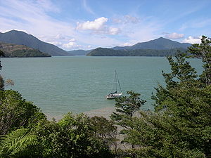
The Marlborough Sounds are an extensive network of sea-drowned valleys created by a combination of land subsidence and rising sea levels at the north of the South Island of New Zealand...
at the north of the South Island, New Zealand
New Zealand
New Zealand is an island country in the south-western Pacific Ocean comprising two main landmasses and numerous smaller islands. The country is situated some east of Australia across the Tasman Sea, and roughly south of the Pacific island nations of New Caledonia, Fiji, and Tonga...
. The Marlborough Sounds is a system of drowned river valleys, which were formed after the last ice age around 10,000 years ago. Pelorus Sound has a main channel which winds south from Cook Strait
Cook Strait
Cook Strait is the strait between the North and South Islands of New Zealand. It connects the Tasman Sea on the west with the South Pacific Ocean on the east....
for about 55 kilometres, between steeply sloped wooded hills, until it reached its head close to Havelock
Havelock, New Zealand
Havelock is a coastal village in the Marlborough region of New Zealand. It sits at the head of Pelorus Sound, one of the Marlborough Sounds. The population was 486 in the 2006 Census, an increase of 12 from 2001....
town. Pelorus has several major arms, notably Tennyson Inlet
Tennyson Inlet
Tennyson Inlet, is the southern arm of Pelorus Sound in the Marlborough Sounds. Tennyson Inlet encompasses Duncan Bay to Tawhitinui Reach. This area is about ten kilometers long . Tarakaipa and Tawhitinui Islands are the two largest islands in the inlet...
, Tawhitinui Reach, Kenepuru Sound
Kenepuru Sound
Kenepuru Sound is one of the larger of the Marlborough Sounds in the South Island of New Zealand. The drowned valley is an arm of Pelorus Sound, it runs for 25 kilometres from the northeast to southwest, joining Pelorus Sound a quarter of the way down the latter's path to the Cook Strait.Queen...
and the Crail/Clova/Beatrix Bay complex.
Industry in Pelorus Sounds is based around marine farming
Aquaculture in New Zealand
Aquaculture started in New Zealand in the late 1960s. It is dominated by mussels, oysters and salmon. In 2007, aquaculture generated about NZ$360 million in sales on an area of 7,700 hectares...
, pine
Pine
Pines are trees in the genus Pinus ,in the family Pinaceae. They make up the monotypic subfamily Pinoideae. There are about 115 species of pine, although different authorities accept between 105 and 125 species.-Etymology:...
forestry and some tourism. Private holiday homes are becoming more common. Most of the settled places are hard to reach overland, and are serviced by the Pelorus Express, a mail boat which does three different weekly runs from Havelock
Havelock, New Zealand
Havelock is a coastal village in the Marlborough region of New Zealand. It sits at the head of Pelorus Sound, one of the Marlborough Sounds. The population was 486 in the 2006 Census, an increase of 12 from 2001....
.
Maud Island
Maud Island
Maud Island, originally called Te Hoiere in the Māori language, is the second-largest island in the Marlborough Sounds on the northern tip of the South Island of New Zealand, with a total area of .-Fauna:...
, originally called Te Hoiere in the Māori language
Maori language
Māori or te reo Māori , commonly te reo , is the language of the indigenous population of New Zealand, the Māori. It has the status of an official language in New Zealand...
, is a 310 hectare island in the Pelorus Sounds. It is an important nature reserve
Nature reserve
A nature reserve is a protected area of importance for wildlife, flora, fauna or features of geological or other special interest, which is reserved and managed for conservation and to provide special opportunities for study or research...
to which only scientists and conservationists have access.
History
_aground_at_low_water.jpg)
Iwi
In New Zealand society, iwi form the largest everyday social units in Māori culture. The word iwi means "'peoples' or 'nations'. In "the work of European writers which treat iwi and hapū as parts of a hierarchical structure", it has been used to mean "tribe" , or confederation of tribes,...
(tribe) of the indigenous people of New Zealand is the Ngāti Kuia
Ngati Kuia
Ngāti Kuia is a Māori iwi of the Northern South Island in New Zealand. They first settled in the Pelorus Sound, and later spread to the Marlborough Sounds, Nelson and Tasman districts to Taitapu on the West Coast, and as far south as the Nelson Lakes National Park...
. According to Ngāti Kuia oral tradition
Maori mythology
Māori mythology and Māori traditions are the two major categories into which the legends of the Māori of New Zealand may usefully be divided...
, their founding father, a descendant of Kupe
Kupe
In the Māori mythology of some tribes, Kupe was involved in the Polynesian discovery of New Zealand.-Contention:There is contention concerning the status of Kupe. The contention turns on the authenticity of later versions of the legends, the so-called 'orthodox' versions closely associated with S....
, came to the South Island in his waka
Waka (canoe)
Waka are Māori watercraft, usually canoes ranging in size from small, unornamented canoes used for fishing and river travel, to large decorated war canoes up to long...
Te Hoiere.
In 1642, Abel Tasman
Abel Tasman
Abel Janszoon Tasman was a Dutch seafarer, explorer, and merchant, best known for his voyages of 1642 and 1644 in the service of the VOC . His was the first known European expedition to reach the islands of Van Diemen's Land and New Zealand and to sight the Fiji islands...
sailed past D'Urville Island
D'Urville Island, New Zealand
D'Urville Island is an island in the Marlborough Sounds along the northern coast of the South Island of New Zealand. It was named after the French explorer Jules Dumont d'Urville. With an area of approximately , it is the eighth-largest island of New Zealand, and has around 52 permanent...
. French and Russian explorers followed and in the 1770s Captain James Cook
James Cook
Captain James Cook, FRS, RN was a British explorer, navigator and cartographer who ultimately rose to the rank of captain in the Royal Navy...
arrived.
In 1838, Philip Chetwode in command of the Cruizer class
Cruizer class brig-sloop
The Cruizer class was an 18-gun class of brig-sloops of the Royal Navy. Brig-sloops were the same as ship-sloops except for their rigging...
brig-sloop, HMS Pelorus
HMS Pelorus
HMS Pelorus is the designation which has been given to numerous ships of the Royal Navy. was an 18-gun Cruizer-class brig-sloop launched in 1808 and wrecked in 1844 while transporting opium to China...
, carried out the first survey of Pelorus Sound. The sound was named in honour of this survey. A pelorus
Pelorus (instrument)
In appearance and use, a pelorus resembles a compass or compass repeater, with sighting vanes or a sighting telescope attached, but it has no directive properties. That is, it remains at any relative direction to which it is set. It is generally used by setting 000° at the lubber's line. Relative...
was a navigational instrument used on sailing ships. The instrument, in turn, was named after the pilot for Hannibal, circa 203 BC.
In 1864, gold was discovered in the Wakamarina Valley and, for a brief time, Havelock became a boom town as several thousand prospectors flooded the area.
In 1865, the first timber mill started at Mahikipawa, an upper arm of Pelorus Sound. More mills were established, and native timber was shipped around New Zealand and to Australia. By the turn of the century the timber camps had largely given way to dairy and sheep farms. In 1939 the last mill was closed. About 325 million feet of timber had been sawn over a period of sixty years, and only two small areas of native timber remained.
In 1888, a Risso’s dolphin appeared in the sounds. This dolphin became famous as Pelorus Jack
Pelorus Jack
Pelorus Jack was a Risso's dolphin that was famous for meeting and escorting ships through a stretch of water in Cook Strait, New Zealand, between 1888 and 1912...
and became the first dolphin in the world to receive the protection of the law. Pelorus Jack would accompany boats to and from the notorious French Pass. He would join boats bound for Nelson at the entrance to Pelorus Sound and for eight kilometres would ride their bow waves to Pelorus Sound. He did not go through the pass with them, but would met returning boats as they exited the pass. Pelorus Jack was last seen in April 1912. The lightkeeper at French Pass claimed he found the body of Pelorus Jack decomposing on the shore.
During World War II
World War II
World War II, or the Second World War , was a global conflict lasting from 1939 to 1945, involving most of the world's nations—including all of the great powers—eventually forming two opposing military alliances: the Allies and the Axis...
, coastal fortifications
Coastal fortifications of New Zealand
Coastal fortifications were constructed in New Zealand in two main waves. The first wave occurred around 1885 and was a response to fears of an attack by Russia. The second wave occurred during World War II and was due to fears of invasion by the Japanese....
were constructed on Maud Island
Maud Island
Maud Island, originally called Te Hoiere in the Māori language, is the second-largest island in the Marlborough Sounds on the northern tip of the South Island of New Zealand, with a total area of .-Fauna:...
to protect Cook Strait
Cook Strait
Cook Strait is the strait between the North and South Islands of New Zealand. It connects the Tasman Sea on the west with the South Pacific Ocean on the east....
, and the entrance to the sound. These fortifications included a 6in Mk 7 gun emplacement, and range finding equipment that is still there today.
In 1906, New Zealand purchased its first naval ship, a sail training ship called NZS Amokura. It became a coal hulk in 1922, and in 1953 was towed into St Omer Bay in Kenepuru Sound
Kenepuru Sound
Kenepuru Sound is one of the larger of the Marlborough Sounds in the South Island of New Zealand. The drowned valley is an arm of Pelorus Sound, it runs for 25 kilometres from the northeast to southwest, joining Pelorus Sound a quarter of the way down the latter's path to the Cook Strait.Queen...
, an arm of Pelorus Sound. It was used there as a store hulk and jetty. Reported broken up in 1955, her remains lie on the beach in the southern end of the bay.
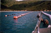
Marine farming
Aquaculture
Aquaculture, also known as aquafarming, is the farming of aquatic organisms such as fish, crustaceans, molluscs and aquatic plants. Aquaculture involves cultivating freshwater and saltwater populations under controlled conditions, and can be contrasted with commercial fishing, which is the...
exports are grown in the Marlborough Sounds, with exports exceeding $NZ
New Zealand dollar
The New Zealand dollar is the currency of New Zealand. It also circulates in the Cook Islands , Niue, Tokelau, and the Pitcairn Islands. It is divided into 100 cents....
200 million per annum. Most of these farms are in Pelorus Sound. Most of the exports come from green-lipped mussels
New Zealand green-lipped mussel
The New Zealand green-lipped mussel, is a bivalve mollusc in the family Mytilidae. P. canaliculus has great importance as a cultivated species for New Zealand.-Distribution:Perna canaliculus has a wide distribution which covers all of New Zealand's mainland. P...
.
A New Zealand sea sponge
Sea sponge
Sponges are animals of the phylum Porifera . Their bodies consist of jelly-like mesohyl sandwiched between two thin layers of cells. While all animals have unspecialized cells that can transform into specialized cells, sponges are unique in having some specialized cells, but can also have...
, Mycale hentscheli, which grows in Pelorus Sound, may hold the key to an anti-cancer drug. Scientists are working to see how peloruside, a substance produced by the sponges, might be used as a cancer-fighting drug. Marine farmers are helping Victoria University of Wellington
Victoria University of Wellington
Victoria University of Wellington was established in 1897 by Act of Parliament, and was a former constituent college of the University of New Zealand. It is particularly well known for its programmes in law, the humanities, and some scientific disciplines, but offers a broad range of other courses...
and NIWA
National Institute of Water and Atmospheric Research
The National Institute of Water and Atmospheric Research or NIWA , is a Crown Research Institute of New Zealand. Established in 1992, NIWA conducts commercial and non-commercial research across a broad range of disciplines in the environmental sciences...
develop a method for growing the sponge on an existing mussel farm.
Trialling of mussel farms began in the Marlborough Sounds in the late 1960s. In the Pelorus Sounds, mussel farms were introduced to Kenepuru Sound and Crail Bay Subsequently, Pelorus has become the major mussel producing area in New Zealand. Initially, the mussels were cultured on on ropes suspended from rafts. It was a labour-intensive method which has since been replaced with a modified Japanese longline system, where mussel spat is packed into stockings, and suspended from parallel rows of looped ropes, supported by buoy
Buoy
A buoy is a floating device that can have many different purposes. It can be anchored or allowed to drift. The word, of Old French or Middle Dutch origin, is now most commonly in UK English, although some orthoepists have traditionally prescribed the pronunciation...
s.
In 1981, the first specially designed mussel processing factory was established at Havelock, at the head of the sounds. Havelock has become the main centre for landing harvested mussels, with other smaller processing plants at French Pass
French Pass
French Pass is a narrow and treacherous stretch of water that separates D'Urville Island, at the north end of the South Island of New Zealand, from the mainland coast. At one end is Tasman Bay, and at the other end the outer Pelorus Sound leads out to Cook Strait.French Pass has the fastest tidal...
, Elaine Bay, Okiwi Bay and Rai Valley
Rai Valley
Rai Valley is a locality in Marlborough, New Zealand. State Highway 6 runs through the area. The Rai River runs past the locality to join the Pelorus River at the locality of Pelorus Bridge to the south. Nelson is 48 km to the west. Okiwi Bay is 22 km to the northeast...
. People are needed to manage and work the farms, and to harvest and transport the mussels to the processing plants. As a result, the mussel farming industry has become closely linked to several local communities.
Heavy rain can result in high sediment levels in rivers and land runoff, and can contain bacterial contamination from livestock. This can result in mussel farming areas being closed to harvesting. Applications to increase mussel farms in Admiralty Bay have been successfully opposed on the grounds that the area is a special feeding site for the dusky dolphin
Dusky Dolphin
The dusky dolphin is a dolphin found in coastal waters in the Southern Hemisphere. Its specific epithet is Latin for "dark" or "dim". It is very closely genetically related to the Pacific white-sided dolphin, but current scientific consensus is that they are distinct species...
. The claim has been made that marine farms
Mariculture
Mariculture is a specialized branch of aquaculture involving the cultivation of marine organisms for food and other products in the open ocean, an enclosed section of the ocean, or in tanks, ponds or raceways which are filled with seawater. An example of the latter is the farming of marine fish,...
significantly affect the ability of the dolphins to round up shoals
Swarm
Swarm behaviour, or swarming, is a collective behaviour exhibited by animals of similar size which aggregate together, perhaps milling about the same spot or perhaps moving en masse or migrating in some direction. As a term, swarming is applied particularly to insects, but can also be applied to...
of pilchard.
Pine forestry
Since the 1970s, large areas of exotic (pinePine
Pines are trees in the genus Pinus ,in the family Pinaceae. They make up the monotypic subfamily Pinoideae. There are about 115 species of pine, although different authorities accept between 105 and 125 species.-Etymology:...
) forest have been planted around the sounds. Bulk timber is exported from a deep-water berth in Shakespeare Bay to the west of Picton
Picton, New Zealand
Picton is a town in the Marlborough region of New Zealand. It is close to the head of Queen Charlotte Sound near the north-east corner of the South Island. The population was 2928 in the 2006 Census, a decrease of 72 from 2001...
.
Māori
The indigenous people of New Zealand are the Māori. The local iwiIwi
In New Zealand society, iwi form the largest everyday social units in Māori culture. The word iwi means "'peoples' or 'nations'. In "the work of European writers which treat iwi and hapū as parts of a hierarchical structure", it has been used to mean "tribe" , or confederation of tribes,...
, Ngāti Kuia
Ngati Kuia
Ngāti Kuia is a Māori iwi of the Northern South Island in New Zealand. They first settled in the Pelorus Sound, and later spread to the Marlborough Sounds, Nelson and Tasman districts to Taitapu on the West Coast, and as far south as the Nelson Lakes National Park...
, has engaged in marine farming
Mariculture
Mariculture is a specialized branch of aquaculture involving the cultivation of marine organisms for food and other products in the open ocean, an enclosed section of the ocean, or in tanks, ponds or raceways which are filled with seawater. An example of the latter is the farming of marine fish,...
with the aim of supplying better employment for their people. They are concerned about protecting their sacred sites, and about the environmental effects of industrial scale marine farming. They have objected to some development projects, such as a mussel farm in an area where their people are starting to return to the land, and a proposed harbour development at Havelock, where the local dump was located near sites and a waterway sacred to Ngati Kuia. Maori groups are becoming better resourced through settlements and income from fisheries quotas. They are more active at looking after their interests. Community tensions have increased, with some interests feeling Māori hold up development.
Tides and currents
Hydrography
Hydrography is the measurement of the depths, the tides and currents of a body of water and establishment of the sea, river or lake bed topography and morphology. Normally and historically for the purpose of charting a body of water for the safe navigation of shipping...
studies in Pelorus Sound. These show the importance of the large, variable freshwater input into Pelorus Sound. The Sound has 380 kilometres (240 mi) of shoreline and an area of 290 square kilometres (112 sq mi). Average freshwater input is 99 cubic metres per second, of which the Pelorus
Pelorus River
The Pelorus River is a river at the northern end of South Island of New Zealand in the region of Marlborough. It flows from the Richmond Range into Pelorus Sound. This area is fantastic for camping and is renowned for its magnificent river swimming where the Pelorus River runs through a gorge....
and Kaituna River
Kaituna River
The Kaituna River is located in the Bay of Plenty region of the North Island of New Zealand. It is the outflow from Lakes Rotorua and Rotoiti, and flows northwards for 45 kilometres, emptying into the Bay of Plenty near Te Puke...
s at the head of the sound deliver 43 and 5 cubic metres per second respectively. Rain falling directly on the surface of the sound provides another 14 cubic metres per second, and the remainder drains from adjacent land via small streams.
This freshwater input corresponds to a depth of 10.8 m of water distributed over the area of the sound per year. The freshwater input is highly variable. In a typical year there are several events where the daily rainfall exceeds 50 mm and the river flow exceeds 400 cubic metres per second. The freshwater inflow generates an estuarine circulation in the main channel, with low-salinity water moving outwards at the surface, and higher-salinity water flowing inwards below. The currents in the main channel associated with this circulation are typically 0.05–0.15 metres per second, but immediately after a flood event they can be much larger. Fresh water layers have been observed to spread through the Sound at 0.9 metres per second. After each flood event, the freshwater is slowly flushed out of the sound, with a flushing time estimated to be 21 days.
The tidal regime at the entrance to Pelorus Sound is typical of New Zealand coastal locations, i.e. there is a semi-diurnal tide modulated on a spring-neap cycle, generated by the superposition of M2 (lunar, semi-diurnal) and S2 (solar, semi-diurnal) tidal constituents. Other tidal constituents, notably N2 (semi-diurnal, generated by the ellipticity of the moon’s orbit), introduce further modulation, meaning that the spring-neap cycle is not exactly repeated. The tidal range varies between 1.0–1.3 m at neap and 2.1–2.4 m at spring. (These values are calculated from a sea level time series, July 1997–February 1998, at Pelorus Sound entrance.) The propagation of this tidal signal into Pelorus Sound has not been well described, but models and measurements both suggest that the tidal range within the sound is somewhat larger (by 10–20%) than at the entrance. Because the sound is long, and in places narrow, the tidal currents are fairly strong.
A further factor affecting the hydrodynamics of Pelorus Sound is wind. Winds in the area are generally strong and are channelled by the steep topography
Topography
Topography is the study of Earth's surface shape and features or those ofplanets, moons, and asteroids...
. Wind stress acting on the surface generates currents, which have not been well described. The wind stress also generates turbulence, which causes the surface fresh water to be mixed down and results in a brackish layer typically 5–15 metres thick. The interface, called a pycnocline
Pycnocline
A pycnocline is the cline or layer where the density gradient is greatest within a body of water. An ocean current is generated by the forces such as breaking waves, terms of temperature and salinity differences, wind, Coriolis effect, and tides caused by the gravitational pull of the Moon and the...
, between the brackish near-surface water and the denser water below supports internal wave motion.
Waves on the pycnocline, called internal waves, are ubiquitous in Pelorus Sound. They propagate at one metres per second and involve vertical displacements of the pycnocline through five metres. They are often generated by the tide, in which case they are called internal tides. They play an important part in driving flow and horizontal exchange in bays off the main channel. For example current meter records at the entrance to Beatrix Bay show a significant semi-diurnal component with velocities up to 0.2 metres per second. This is not simple, uniform tidal flow in and out of the bay because its amplitude does not follow a spring-neap cycle and there is a phase difference of several hours between the surface and the bottom.
Timeline
- Mists of time: The founding father of the Ngāti KuiaNgati KuiaNgāti Kuia is a Māori iwi of the Northern South Island in New Zealand. They first settled in the Pelorus Sound, and later spread to the Marlborough Sounds, Nelson and Tasman districts to Taitapu on the West Coast, and as far south as the Nelson Lakes National Park...
arrives in the South Island in his canoe Te Hoiere - 1642: Abel TasmanAbel TasmanAbel Janszoon Tasman was a Dutch seafarer, explorer, and merchant, best known for his voyages of 1642 and 1644 in the service of the VOC . His was the first known European expedition to reach the islands of Van Diemen's Land and New Zealand and to sight the Fiji islands...
sails past D'Urville IslandD'Urville Island, New ZealandD'Urville Island is an island in the Marlborough Sounds along the northern coast of the South Island of New Zealand. It was named after the French explorer Jules Dumont d'Urville. With an area of approximately , it is the eighth-largest island of New Zealand, and has around 52 permanent...
. - Late 17th century: French and Russian explorers arrive.
- 1770s: Captain James CookJames CookCaptain James Cook, FRS, RN was a British explorer, navigator and cartographer who ultimately rose to the rank of captain in the Royal Navy...
arrives. - 1827: Jules Dumont d'UrvilleJules Dumont d'UrvilleJules Sébastien César Dumont d'Urville was a French explorer, naval officer and rear admiral, who explored the south and western Pacific, Australia, New Zealand and Antarctica.-Childhood:Dumont was born at Condé-sur-Noireau...
has a disconcerting ride through French PassFrench PassFrench Pass is a narrow and treacherous stretch of water that separates D'Urville Island, at the north end of the South Island of New Zealand, from the mainland coast. At one end is Tasman Bay, and at the other end the outer Pelorus Sound leads out to Cook Strait.French Pass has the fastest tidal...
in the French Navy corvette Astrolabe. - 1838: HMS PelorusHMS PelorusHMS Pelorus is the designation which has been given to numerous ships of the Royal Navy. was an 18-gun Cruizer-class brig-sloop launched in 1808 and wrecked in 1844 while transporting opium to China...
, carries out the first survey. The sound is named in honour of this survey. - 1864: Gold is discovered in the Wakamarina Valley, and briefly Havelock becomes a boom town.
- 1865: Milling of native timber begins
- 1870: A flax mill starts operating on the Ruapeka Stream
- 1888: First appearance of the dolphin Pelorus JackPelorus JackPelorus Jack was a Risso's dolphin that was famous for meeting and escorting ships through a stretch of water in Cook Strait, New Zealand, between 1888 and 1912...
. - c. 1900: The timber camps are giving way to dairy and sheep farms.
- 1912: Pelorus Jack dies.
- 1939: The last native timber mill closes. Only two small areas of native timber remain
- 1942: Coastal fortificationsCoastal fortifications of New ZealandCoastal fortifications were constructed in New Zealand in two main waves. The first wave occurred around 1885 and was a response to fears of an attack by Russia. The second wave occurred during World War II and was due to fears of invasion by the Japanese....
are constructed on Maud IslandMaud IslandMaud Island, originally called Te Hoiere in the Māori language, is the second-largest island in the Marlborough Sounds on the northern tip of the South Island of New Zealand, with a total area of .-Fauna:...
to protect Cook StraitCook StraitCook Strait is the strait between the North and South Islands of New Zealand. It connects the Tasman Sea on the west with the South Pacific Ocean on the east....
, and the entrance to the sound. - 1953: NZS Amokura, New Zealand's first naval ship, is towed into St Omer Bay in Kenepuru SoundKenepuru SoundKenepuru Sound is one of the larger of the Marlborough Sounds in the South Island of New Zealand. The drowned valley is an arm of Pelorus Sound, it runs for 25 kilometres from the northeast to southwest, joining Pelorus Sound a quarter of the way down the latter's path to the Cook Strait.Queen...
, an arm of Pelorus Sound, and retired on the beach, where her remains lie to this day. - 1960s: There is a general decline in wet fish and scallopScallopA scallop is a marine bivalve mollusk of the family Pectinidae. Scallops are a cosmopolitan family, found in all of the world's oceans. Many scallops are highly prized as a food source...
harvests, as some wild fisheries collapse due to overfishingOverfishingOverfishing occurs when fishing activities reduce fish stocks below an acceptable level. This can occur in any body of water from a pond to the oceans....
. - Late 1960s: Mussel farming begins.
- 1981: The first specially designed mussel processing factory is established at Havelock.