
Papanui
Encyclopedia
Christchurch
Christchurch is the largest city in the South Island of New Zealand, and the country's second-largest urban area after Auckland. It lies one third of the way down the South Island's east coast, just north of Banks Peninsula which itself, since 2006, lies within the formal limits of...
New Zealand
New Zealand
New Zealand is an island country in the south-western Pacific Ocean comprising two main landmasses and numerous smaller islands. The country is situated some east of Australia across the Tasman Sea, and roughly south of the Pacific island nations of New Caledonia, Fiji, and Tonga...
. It is sited five kilometers to the northwest of the city centre
Christchurch Central City
Christchurch Central City is the geographical centre and the heart of Christchurch, New Zealand. It is defined as the area within the four avenues and thus includes the densely built up central city, some less dense surrounding areas of residential, educational and industrial usage, and green...
. Papanui is a middle socio-economic area with a population of 3,543 consisting predominantly of Pākehā
Pakeha
Pākehā is a Māori language word for New Zealanders who are "of European descent". They are mostly descended from British and to a lesser extent Irish settlers of the nineteenth and twentieth centuries, although some Pākehā have Dutch, Scandinavian, German, Yugoslav or other ancestry...
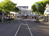
(NZ European & Others) 92.3%, Māori 5.7%, Pacific peoples 2.5%, Asian 5.0%, Middle Eastern/Latin American/African 0.5% (2006 Census). The suburb is located at the junction of three busy thoroughfares; Papanui Road leading to the City, the Main North Road that leads to North Canterbury and Harewood Road that leads to Christchurch International Airport
Christchurch International Airport
-Facts & figures:As the gateway for Christchurch and the South Island, Christchurch International Airport is New Zealand’s second largest airport.5,908,077 passengers travelled in and out of Christchurch International Airport from 1 July 2008 to 30 June 2009...
. However, as with most Christchurch suburbs, Papanui has no defined borders. Christchurch is internationally known as the "Garden City" and Papanui is a fine example of the city's gardening prowess. The city has warm summers and cool winters, and is the gateway to Mount Hutt and other Southern Alps
Southern Alps
The Southern Alps is a mountain range extending along much of the length of New Zealand's South Island, reaching its greatest elevations near the island's western side...
ski-fields, and to whale watching in Kaikoura
Kaikoura
Kaikoura is a town on the east coast of the South Island of New Zealand. It is located on State Highway 1 180 km north of Christchurch.Kaikoura became the first local authority to reach the Green Globe tourism certification standard....
.
Etymology
The Māori nameMaori language
Māori or te reo Māori , commonly te reo , is the language of the indigenous population of New Zealand, the Māori. It has the status of an official language in New Zealand...
Papanui literally translated means 'Big plain' (papa means flat and nui means big), a name which would aptly suit most of central Christchurch, which is one of New Zealand's flattest cities. Another meaning, equally applicable to the district in the early days, is a platform set in the branches of a tree to accommodate a bird-spearer. A third meaning for the word Papanui comes from a Māori Legend and refers to a large funeral pyre. According to the legend, Tuhaitara, a Ngāi Tahu
Ngāi Tahu
Ngāi Tahu, or Kāi Tahu, is the principal Māori iwi of the southern region of New Zealand, with the tribal authority, Te Rūnanga o Ngāi Tahu, being based in Christchurch and Invercargill. The iwi combines three groups, Kāi Tahu itself, and Waitaha and Kāti Mamoe who lived in the South Island prior...
princess, sent her eldest son, Tamarairoa to Papanui to kill her former husband Marukore. But Marukore was aware of his sons intentions and when Tamarairoa and his younger brother arrived Marukore killed them both and burnt their bodies on a huge pyre.
Papanui today
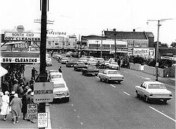
Over the last 160 years Papanui has developed into a major suburban centre and is a satellite centre for Government and City Council services. These include the central government 'Super Centre' in Winstone Avenue, Housing New Zealand in Restell Street and the Council Service Centre and Library on Langdons Road. The area has two high schools and five primary schools. Commercial growth has been strong with most of the Trades and Professions centred around the shopping areas. There is little farm land left in the suburb with most of it having been developed into residential and commercial properties. The original Papanui shopping village is located at the Papanui Junction and the area is home to Northlands Shopping Centre on the Main North Road, which is one of the largest malls in the South IslandSouth Island
The South Island is the larger of the two major islands of New Zealand, the other being the more populous North Island. It is bordered to the north by Cook Strait, to the west by the Tasman Sea, to the south and east by the Pacific Ocean...
.
Lifestyle
There are nine Retirement Villages in the area. Albarose Rest Home is on Harewood Road; Camellia Court Rest Home http://www.camelliacourtresthome.co.nz/ is on Harewood Road; Condell Retirement Village http://www.condelllifestylevillage.co.nz/ is on Condell Avenue; The Golden Age Retirement Village is on Harewood Road; Ngaio Marsh Retirement Village http://www.rymanhealthcare.co.nz/villages/ngaio_marsh/index.html is on Grants Road; Parklands Hospital & Nursing Home is on Papanui Road; Wendover Retirement Village is on Erica Street; Wesleycare Rest Home is on Harewood Road; Windermere Retirement Village http://www.oceanialiving.co.nz/ is on Windermere Road.Parks
There are numerous reserves and parks within the suburban boundaries, the two most notable of these are as follow:The Papanui Domain sited on Sawyers Arms Road where the Papanui Bush was clear felled in the 1850s. It is predominantly used for Rugby League and Softball, with the Rugby League clubrooms adjoining on the southern boundary. In the early days it was also used for cycle racing.
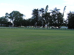
St James Park, most likely named after its road frontage, is predominantly used for croquet
Croquet
Croquet is a lawn game, played both as a recreational pastime and as a competitive sport. It involves hitting plastic or wooden balls with a mallet through hoops embedded into the grass playing court.-History:...
, cricket and soccer. It is probably one of the most beautiful parks in the city with tree lined walkways and gardens. The Park in the heart of Papanui is probably the best location to see over-wintering monarch butterflies
Monarch butterfly
The Monarch butterfly is a milkweed butterfly , in the family Nymphalidae. It is perhaps the best known of all North American butterflies. Since the 19th century, it has been found in New Zealand, and in Australia since 1871 where it is called the Wanderer...
. On a warm sunny late autumn or early winter's day head to the children's play ground and look into the largely leafless old trees. There you will see monarchs clustering together often holding on to the remaining leaves for support. It ís a great spot for a picnic beneath the trees with monarchs fluttering in the air above.
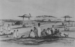
Pre-European
Before European settlement Papanui, like much of Christchurch, was mostly marshy ground covered with native Flax,http://www.doc.govt.nz/conservation/native-plants/harakeke-flax/ Toetoe http://www.landcareresearch.co.nz/research/biosystematics/plants/weaving/toetoe.asp and Raupo brush.http://www.landcareresearch.co.nz/research/biosystematics/plants/weaving/raupo.asp There was an abundance of forest birds which were hunted for food by the area's Māori inhabitants. It is believed in 1800 possibly as many as 5000 Māori lived in Canterbury, but from disease like measles and influenza, introduced through the early whalingWhaling
Whaling is the hunting of whales mainly for meat and oil. Its earliest forms date to at least 3000 BC. Various coastal communities have long histories of sustenance whaling and harvesting beached whales...
settlements on Banks Peninsula
Banks Peninsula
Banks Peninsula is a peninsula of volcanic origin on the east coast of the South Island of New Zealand. It has an area of approximately and encompasses two large harbours and many smaller bays and coves...
, and through tribal wars the number had fallen to around 500 in 1840. While most of the plains in the South Island of New Zealand were deforested by either the Māori or the so called Moa
Moa
The moa were eleven species of flightless birds endemic to New Zealand. The two largest species, Dinornis robustus and Dinornis novaezelandiae, reached about in height with neck outstretched, and weighed about ....
Hunters in the mid 1300's, Papanui Bush was one of the few stands of pine and totara left in the Canterbury region at the time of European colonisation.
European colonisation
The Canterbury Association’sCanterbury Association
The Canterbury Association was formed in order to establish a colony in what is now the Canterbury Region in the South Island of New Zealand.- Formation of the Association :...
surveyor Captain Joseph Thomas and his team of surveyors arrived in Lyttelton
Lyttelton, New Zealand
Lyttelton is a port town on the north shore of Lyttelton Harbour close to Banks Peninsula, a suburb of Christchurch on the eastern coast of the South Island of New Zealand....
(originally named Port Cooper) on 15 December 1848 on the ship 'Fly'. They began to survey the Port Hills
Port Hills
The Port Hills form the northern rim of the ancient Lyttelton volcano, separating the port of Lyttelton from the city of Christchurch in Canterbury, New Zealand...
and Canterbury Plains around what would become Christchurch and its suburbs. As chief agent for the association Thomas was also responsible for preparing the infrastructure for the arrival of the first settlers at Lyttelton in December 1850. The First Four Ships, Charlotte Jane, Randolph, Sir George Seymour and Cressy landed 773 colonists. By the first anniversary of the first landing fifteen more ships had arrived bringing the colonist population to 3,000. By 1876 the estimated population of the city and suburbs was around 23,000 with the number increasing to 44,000 by 1886.
Papanui Bush
When the pilgrims first began to settle in Christchurch in the early 1851, Papanui Bush attracted a number of Sawyers who made a living from milling Totara and PinePine
Pines are trees in the genus Pinus ,in the family Pinaceae. They make up the monotypic subfamily Pinoideae. There are about 115 species of pine, although different authorities accept between 105 and 125 species.-Etymology:...
timber for construction and fire wood. Near the bush a settlement sprung up along on the old Maori track leading north to Kaiapoi
Kaiapoi
Kaiapoi is a town in the Canterbury region of the South Island of New Zealand, located close to the mouth of the Waimakariri River, and approximately 17 kilometres north of Christchurch....
which eventually became the Main North Road. The settlement soon boasted a hotel, store, blacksmiths, clothing shop, butchers, chemist, dispensers, and a school room appeared in 1853. Due to the pressing need for building materials in Christchurch, Papanui Road was one of the first roads built outside the city boundaries. The Papanui Bridge was also built over the Avon River
Avon River, Canterbury
The Avon River flows through the centre of the city of Christchurch, New Zealand, and out to an estuary, which it shares with the Heathcote River, the Avon Heathcote Estuary.- Geology :...
in March 1852 to allow the timber to be brought by bullock drawn wagons directly into the Market Square near the city centre. It is interesting to note that in 1857 sawmilling had attracted a population of 692 to the Papanui village compared with 953 in Christchurch in the same year.
Farm land
By 1857 most of the trees in the area were felled and market gardeningMarket gardening
A market garden is the relatively small-scale production of fruits, vegetables and flowers as cash crops, frequently sold directly to consumers and restaurants. It is distinguishable from other types of farming by the diversity of crops grown on a small area of land, typically, from under one acre ...
and orchards began to flourish. The land around Papanui proved to be remarkably fertile for farming once ditches and drains were dug to relieve the swampy areas. Gradually more immigrants settled in Papanui, crops were sown and sheep and dairy
Dairy
A dairy is a business enterprise established for the harvesting of animal milk—mostly from cows or goats, but also from buffalo, sheep, horses or camels —for human consumption. A dairy is typically located on a dedicated dairy farm or section of a multi-purpose farm that is concerned...
farms were established in the surrounding areas. Exports of Wheat
Wheat
Wheat is a cereal grain, originally from the Levant region of the Near East, but now cultivated worldwide. In 2007 world production of wheat was 607 million tons, making it the third most-produced cereal after maize and rice...
and Wool
Wool
Wool is the textile fiber obtained from sheep and certain other animals, including cashmere from goats, mohair from goats, qiviut from muskoxen, vicuña, alpaca, camel from animals in the camel family, and angora from rabbits....
soon became the main source of income for the province. From the mid 1880's frozen Mutton shipments, from the nearby Canterbury Frozen Meat Company in Belfast, to the U.K. grew steadily and eventually surpassed other exports to become the main export earner. In the 1890s Butter
Butter
Butter is a dairy product made by churning fresh or fermented cream or milk. It is generally used as a spread and a condiment, as well as in cooking applications, such as baking, sauce making, and pan frying...
shipments joined the export trade with the Fernleaf brand becoming as well known as 'Canterbury Lamb'. As settlement of Christchurch continued farms were sold for residential and commercial developments with Papanui being transformed into a suburb which became part of Christchurch city in 1923.
Hotels
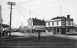
One of the first buildings in the area was the Sawyers Arms Hotel which was opened by an American named Robert Carr. The Hotel was built on the Main North Road near the corner of Sawyers Arms Road which derived its name from the hotel. Henry Roil was also "mine host" at the hotel in the early years as a partner of Carr's. The hotel burnt down twice, firstly in November 1874 and was reopened by the current licensee John Wild in June 1875. The second fire occurred in September 1898 and was rebuilt by the licensee John Cooper and was renamed The Phoenix (the beautiful bird rising from the ashes) for its third incarnation. This building was finally demolished in February 1989 in a Supermarket redevelopment with the site eventually being encompassed by the Northlands Shopping Centre.The Papanui Hotel was originally built in the early 1850s as a parsonage for the Reverend Bradley. The building was bought in 1859 by William Meddings, a local blacksmith and store keeper, who opened it as a hotel. In 1865 the hotel was bought by William Lawrence who rebuilt the front section in 1871. Lawrence passed the hotel on to his son William in 1898, and it is believed it remained in the Lawrence family ownership until 1906. The grounds boasted gardens, lawns, fruit trees, walkways and a skittle bowling alley. In 1957 a new public and lounge bar complex was built on the corner of the Main North Road and Winstone Avenue adjacent to the old building which was finally demolished in March 1969 having served as a landmark for 110 years.
Churches
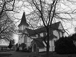
The area is home to one of the oldest parishes on the Canterbury plains. Established in 1853, St Paul's Anglican Churchhttp://christchurchcitylibraries.com/Heritage/Cemeteries/Papanui/ on Harewood Road was enlarged twice before being rebuilt using Kauri timber in 1877 to the design of the notable architect Benjamin Mountfort
Benjamin Mountfort
Benjamin Woolfield Mountfort was an English emigrant to New Zealand, where he became one of that country's most prominent 19th century architects. He was instrumental in shaping the city of Christchurch's unique architectural identity and culture, and was appointed the first official Provincial...
. In 1880 a peal of five bells was presented to the church by Mr J T Matson. This was the first ring of bells suitable for change ringing
Change ringing
Change ringing is the art of ringing a set of tuned bells in a series of mathematical patterns called "changes". It differs from many other forms of campanology in that no attempt is made to produce a conventional melody....
to be installed in New Zealand and is the only ringable set in the country of eight bells housed in a wooden tower. St Paul’s has the additional distinction of being the only parish church in New Zealand with bells for change ringing - the other rings are in cathedrals. The original ring of five bells was ordered in 1878. Some time later, ringing was suspended because the tower was no longer strong enough but a new one was constructed in 1912 and it was again strengthened in 1981 by an internal steel frame. The set is a light weight ring for change ringing
Change ringing
Change ringing is the art of ringing a set of tuned bells in a series of mathematical patterns called "changes". It differs from many other forms of campanology in that no attempt is made to produce a conventional melody....
with the tenor at 317 kg which protects the tower. A sixth bell was added in 1970 and two more in 1983.
The second oldest church in the area is the Papanui Methodist Church http://www.methodist.org.nz/index.cfm/Find_Us/Central_South_Island/Parish_Information/Christchurch_North_Methodist_Parish which was established in 1859. The second church was built in 1870 and the third and present church was opened in 1913 on the corner of Harewood Road and Chapel Street.
This was followed By St Giles Presbyterian Church http://www.stgiles.info/ which was first built in 1877 on the Main North Road three doors past the current Catholic church. In 1895 the church was further enlarged but this eventually proved to be insufficient and in 1924 a new church was built on the corner of Papanui Road and Frank Street.
St Joseph's Catholic Church http://www.stjosephspapanui.org.nz/ conducted services in the St Josesph's School Chapel, designed by Mr Jacobson and built on Vagues Road, from 1878 until the current church was built on the corner of the Main North Road and Vagues Road in March 1922. The Parish was formally established in 1924 with Fr Hanrahan as the first incumbent priest.
The Papanui Baptist Church http://www.papbap.org.nz/ was established in 1958 and is located on Sawyers Road opposite to Morrison Avenue.
The Papanui Seventh-day Adventist Church http://papanui.adventist.org.nz/ is located on Grants Road adjoining the Christchurch Adventist School.
St Paul's cemetery
The graveyard at St Paul's Church is the last resting place for numerous notable Cantabrians and among these are:William Guise Brittan (1809–1876) Commissioner of Crown Lands and a founder of the Canterbury Settlement.http://www.teara.govt.nz/1966/B/BrittanWilliamGuise/BrittanWilliamGuise/en He owned about 100 acre (0.404686 km²) of the Papanui Bush, donated timber for building the first St Paul's Church and was a trustee of the Deans Estate.
Edward Dobson
Edward Dobson
Edward Dobson was Provincial Engineer for the Canterbury Province from 1854 to 1868.-Early life:Edward Dobson was born in London, probably in 1816 or 1817. His parents were John Dobson, a merchant, and Elizabeth Barker. By the time he started his apprenticeship as an architect and surveyor in...
(1816–1908) was the first Provincial Engineer. Amongst other achievements he engineered the Lyttelton Rail Tunnel and oversaw the erection of the stop banks and groynes to prevent the mighty Waimakariri River
Waimakariri River
The Waimakariri River is the largest of the North Canterbury rivers, in the South Island of New Zealand. It flows for 151 kilometres in a generally southeastward direction from the Southern Alps across the Canterbury Plains to the Pacific Ocean....
from flooding Christchurch.
Sir (Robert) Heaton Rhodes
Heaton Rhodes
Sir Robert Heaton Rhodes KCVO KBE VD , usually known as Sir Heaton Rhodes, was a New Zealand politician and lawyer....
K.C.V.O. K.B.E (1861–1956) Barrister, Farmer and Minister of the Crown who held the Portfolios for Public Health, Defense and was Postmaster General. He fought in the Boer War
Boer War
The Boer Wars were two wars fought between the British Empire and the two independent Boer republics, the Oranje Vrijstaat and the Republiek van Transvaal ....
, travelled to Gallipoli at his own expense to ensure the New Zealand soldiers were be well treated, helped establish the Nurse Maude District Nursing scheme and the Royal New Zealand Air Force
Royal New Zealand Air Force
The Royal New Zealand Air Force is the air arm of the New Zealand Defence Force...
, was knighted on 1920 and again in 1927 and provided land and money for philanthropic projects.
Captain Charles Upham
Charles Upham
Captain Charles Hazlitt Upham VC and Bar was a New Zealand soldier who earned the Victoria Cross twice during the Second World War: in Crete in May 1941, and at Ruweisat Ridge, Egypt, in July 1942...
(1908–1994) V.C and Bar, was a farmer who in World War II
World War II
World War II, or the Second World War , was a global conflict lasting from 1939 to 1945, involving most of the world's nations—including all of the great powers—eventually forming two opposing military alliances: the Allies and the Axis...
became a New Zealand hero by winning two Victoria Cross
Victoria Cross
The Victoria Cross is the highest military decoration awarded for valour "in the face of the enemy" to members of the armed forces of various Commonwealth countries, and previous British Empire territories....
es for bravery. The first was won in Crete
Crete
Crete is the largest and most populous of the Greek islands, the fifth largest island in the Mediterranean Sea, and one of the thirteen administrative regions of Greece. It forms a significant part of the economy and cultural heritage of Greece while retaining its own local cultural traits...
in May 1941 and the second in July 1942 at Ruweisat Ridge near El Alamein
El Alamein
El Alamein is a town in the northern Matrouh Governorate of Egypt. Located on the Mediterranean Sea, it lies west of Alexandria and northwest of Cairo. As of 2007, it has a local population of 7,397 inhabitants.- Climate :...
in Egypt
Egypt
Egypt , officially the Arab Republic of Egypt, Arabic: , is a country mainly in North Africa, with the Sinai Peninsula forming a land bridge in Southwest Asia. Egypt is thus a transcontinental country, and a major power in Africa, the Mediterranean Basin, the Middle East and the Muslim world...
.
Landmarks
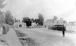
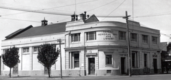
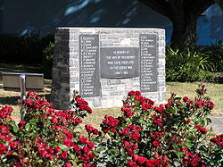
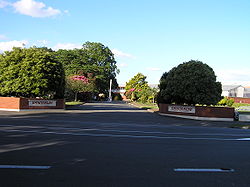
In the 1920s the residents wanted a fitting memorial to the fallen soldiers of World War I. Duly the Memorial Hall and Library (pictured above) was built and opened in the heart of Papanui 1923. This building served as the Town Hall, library and picture theatre for over 50 years, until it was demolished in the late 1970s with the land reverting to a reserve. In 1997 the Returned Services Association prevailed upon the Council to redevelop the site as a war memorial reserve and to include the names of the fallen soldiers from World War II.Transportation
Horse
The horse is one of two extant subspecies of Equus ferus, or the wild horse. It is a single-hooved mammal belonging to the taxonomic family Equidae. The horse has evolved over the past 45 to 55 million years from a small multi-toed creature into the large, single-toed animal of today...
s and bullocks provided the pulling power for wagons, dray
Wagon
A wagon is a heavy four-wheeled vehicle pulled by draught animals; it was formerly often called a wain, and if low and sideless may be called a dray, trolley or float....
s, coaches
Stagecoach
A stagecoach is a type of covered wagon for passengers and goods, strongly sprung and drawn by four horses, usually four-in-hand. Widely used before the introduction of railway transport, it made regular trips between stages or stations, which were places of rest provided for stagecoach travelers...
, cabs
Cabriolet (carriage)
A cabriolet is a light horse-drawn vehicle, with two wheels and a single horse. The carriage has a folding hood that can cover its two occupants, one of whom is the driver. It has a large rigid apron, gracefully upward-curving shafts, and usually a rear platform between the C springs for a groom...
, vans, traps, gigs
Gig (carriage)
A gig, also called chair or chaise, is a light, two-wheeled sprung cart pulled by one horse.-Description:Gigs travelling at night would normally carry two oil lamps with thick glass, known as gig-lamps. Gig carts are constructed with the driver's seat sitting higher than the level of the shafts. ...
and cart
Cart
A cart is a vehicle designed for transport, using two wheels and normally pulled by one or a pair of draught animals. A handcart is pulled or pushed by one or more people...
s of all dimensions. This gave rise to stable
Stable
A stable is a building in which livestock, especially horses, are kept. It most commonly means a building that is divided into separate stalls for individual animals...
, blacksmith
Blacksmith
A blacksmith is a person who creates objects from wrought iron or steel by forging the metal; that is, by using tools to hammer, bend, and cut...
, farrier
Farrier
A farrier is a specialist in equine hoof care, including the trimming and balancing of horses' hooves and the placing of shoes on their hooves...
and saddlery businesses in the Papanui area. Hitching posts and water troughs were common place especially at 'watering holes' like the Papanui Hotel.
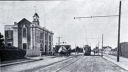
When Canterbury's first railways were built the Main North Line was opened through Papanui on the 27th April 1872. The current Railway Station, though planned and designed in 1872 was not opened until 1900. In the 28 intervening years a 25x8 foot shed did 'Station' duty. A tram line was laid on Papanui Road in 1880 terminating at the Papanui Railway Station. The first Trams
Christchurch tramway system
The Christchurch tramway system was an extensive network in Christchurch, New Zealand, with steam and horse trams from 1882. Electric trams ran from 1905 to 1954, when the last line to Papanui was replaced by buses...
were steam and horse drawn until the introduction of electric trams on the Papanui line in 1905.
The Northcote extension to St Bede's College
St Bede's College, Christchurch
St. Bede's College is a Roman Catholic day and boarding school in Christchurch, New Zealand for boys aged 13 to 18 . St. Bede's is the oldest Roman Catholic Boys' College in New Zealand's South Island. It is also the only Catholic day and boarding college for boys in New Zealand's South Island....
was opened on 28 February 1913 and closed on 30 September 1930. With the exception of the first few tram-cars, which were brought from the United States
United States
The United States of America is a federal constitutional republic comprising fifty states and a federal district...
, the trams were made by a local firm, Boon & Co. The last tram to Papanui ran in 1954 with the trams being replaced by bright red buses run by the Christchurch Transport Board (later the Red Bus Company).http://www.redbus.co.nz/
Policing
After 80 years a new police station and residence was opened in 1959 on Papanui Road just south of the Blighs Road intersection. In 1979 the Senior Sergeant's residence was converted into offices with a CIB office being opened in the same year. Detective Sergeant Roy Powell was the first appointee. The first policewoman stationed at Papanui, in September 1978, was Constable Diane Smith.
For Papanui residents in the 1950s and 1960s the name 'Handlebar Harry' will bring back memories of a tall policeman on a push bike. Constable Ronald Miles was the local enquiry officer and had the habit of riding the streets of Papanui with his typewriter strapped to the handlebars of his cycle. However it was not the position of the typewriter that earned him the nickname, it was his wonderful 'Jimmy Edwards'
Jimmy Edwards
Jimmy Edwards DFC was an English comedic script writer and comedy actor on both radio and television, best known as Pa Glum in Take It From Here and as the headmaster 'Professor' James Edwards in Whack-O!-Biography:...
style flowing moustache.
The current Police Station is opposite Langdons Road on the corner of the Main North Road and Mary Street and was opened on 30 October 1991.
As an interesting foot note the Watch House has survived the years and can now be seen amongst Lady Isaac's collection of heritage buildings at McArthurs Road, Harewood.
Industrial development
Sanitarium Health Food Company
The Sanitarium Health & Wellbeing Company is the trading name of two sister food companies . Both are wholly owned by the Seventh-day Adventist Church....
in Michigan
Michigan
Michigan is a U.S. state located in the Great Lakes Region of the United States of America. The name Michigan is the French form of the Ojibwa word mishigamaa, meaning "large water" or "large lake"....
in the United States, emigrated to New Zealand and began making health foods in a wooden shed in Papanui, including Granola
Granola
Granola is a breakfast food and snack food, popular in North America, consisting of rolled oats, nuts, honey, and sometimes rice, that is usually baked until crisp. During the baking process the mixture is stirred to maintain a loose, breakfast cereal-type consistency...
, New Zealand's first breakfast cereal. Halsey's business was successful, and the Sanitarium Health Food factory was built on the side of Halseys shed in 1919. It is still in operation today; however it was rebuilt in 1966 after being destroyed in a fire. Over recent decades Sanitarium's Harewood Road factory has been awarded many honours for its prize winning gardens.
The building of the Firestone
Bridgestone
The is a multinational rubber conglomerate founded in 1931 by in the city of Kurume, Fukuoka, Japan. The name Bridgestone comes from a calque translation and transposition of ishibashi, meaning "stone bridge" in Japanese....
(now Bridgestone) tyre factory, in Langdons Road, was commenced on land, some of which was a 5 acre orchard purchased from the Cone family, in 1945. Firestone produced New Zealand's first pneumatic tyre in 1948. This factory remained the only tyre manufacturer in the South Island.
On 23 October 2009, it was announced that Bridgestone's Australia and New Zealand manufacturing operations were to close. The announcement affected 275 jobs in Christchurch. In November 2010 the Company has returned 3.2 acres of the former orchard land alongside the railway line to the city to be used as a public wetlands.
The delicatessen meat company, Verkerks http://www.verkerks.co.nz/our-legacy, built a factory on Vagues Road in 1961, and has been stocking the small goods shelves ever since.
Though both of these factories are still in operation today but not so for the Ovaltine
Ovaltine
Ovaltine is a brand of milk flavoring product made with malt extract , sugar , cocoa, and whey...
factory on the Main North Road and the Birdseye Frozen Foods
Birds Eye
__FORCETOC__Birds Eye is an international brand of frozen foods owned by Pinnacle Foods in North America and by private equity group Permira in Europe....
factory which used to be sited next to the railway line in Harewood Road.
Parks
St James Park was originally 'glebe land' belonging to St Paul's church and was divorced from the main church property by the laying of the Main North Railway line in the early 1870s. It is believed to have been farmed by James Triggs, the St Paul's Church verger, and part of it was developed as a cricket ground by the Papanui Cricket Club under the captaincy of John Matson with the permission of Rev. Lorenzo Moore. By 1874 the new incumbent at St Paul's, the Rev Brittan, had joined the Cricket Club as a player, but had also leased some of the land to Mr Jackson, another club member, for stock grazing. The land appears in an 1880 map as a cricket ground, but was later abandoned by the cricket club and sold to Ivorys Cool Stores in 1916. The land was purchased by the City in 1924 after residents, led by Rev Griffin, petitioned the council for a park and has both main entrances sited on St James Avenue. It was named in a Public Notice drawn up by the Christchurch City Council Bylaws and Finance committee chaired by Councilor Andrews on 30 April 1924. Rev Griffin did not live to see the park opened, and as a mark of respect Memorial Gates and a rose garden we jointly funded by the residents and the Council in his honour.Economy
From the 2006 Census, the median income in Papanui is NZ$25,000 compared to a median of $23,500 for Canterbury. In the higher income bracket, 21.3% of the population earns more than $50,000 compared to 15.8% which is the Canterbury average. Most of the population is employed in retail, distribution, sawmills, the apparel industry and the meat works.Unemployment in Papanui is currently low — 3.4% according to figures from the Ministry of Social Development (end of 2007).
Education
There is a high standard of education in the Papanui area. The main educational centre is Papanui High SchoolPapanui High School
Papanui High School is a secondary school in Papanui, a suburb of Christchurch city, New Zealand.Papanui High School is a coeducational secondary school, located between Northlands Mall and Firestone tyre factory, opposite the Christchurch Sanitarium Health Food Company factory...
opened in 1936 which is located adjacent to the rear of Northlands Shopping Centre on Langdons Road. As well as the day classes, the School offers 'continuing education' night classes on a wide range of hobbies and skills. The other High School in the area is St Bede's College (Catholic) which was established in 1911 on Ferry Road and opened on its current site on the Main North Road in 1920 as a day and boarding school.http://www.stbedes.school.nz/history.html
Papanui Primary School http://www.papanuiprimary.school.nz/ was established in 1871 on Winters Road near the Main North Road corner. The school was rebuilt further along Winters Road on 6 acres (24,281.2 m²) of land moved to the new site in September 1926. The next school to be establisted was St Joseph's Primary School http://www.stjopapa.school.nz/ (Catholic) which opened on Vagues Road in 1878. Waimairi Primary School http://www.waimairi.school.nz/ opened on Tillman Avenue in 1914 and the Christchurch Adventist School http://www.cas.school.nz/ opened on Grants Road in 1925. Loreto College (Catholic) opened on Windermere Road on 1930 but was closed in 1978. Paparoa Street Primary School http://www.paparoastreet.school.nz/ opened in 1953.