
Waimakariri River
Encyclopedia
Canterbury, New Zealand
The New Zealand region of Canterbury is mainly composed of the Canterbury Plains and the surrounding mountains. Its main city, Christchurch, hosts the main office of the Christchurch City Council, the Canterbury Regional Council - called Environment Canterbury - and the University of Canterbury.-...
rivers, in the South Island
South Island
The South Island is the larger of the two major islands of New Zealand, the other being the more populous North Island. It is bordered to the north by Cook Strait, to the west by the Tasman Sea, to the south and east by the Pacific Ocean...
of New Zealand
New Zealand
New Zealand is an island country in the south-western Pacific Ocean comprising two main landmasses and numerous smaller islands. The country is situated some east of Australia across the Tasman Sea, and roughly south of the Pacific island nations of New Caledonia, Fiji, and Tonga...
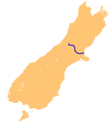
. It flows for 151 kilometres in a generally southeastward direction from the Southern Alps
Southern Alps
The Southern Alps is a mountain range extending along much of the length of New Zealand's South Island, reaching its greatest elevations near the island's western side...
across the Canterbury Plains
Canterbury Plains
The Canterbury Plains are an area in New Zealand centred to the south of the city of Christchurch in the Canterbury Region. Their northern extremes are at the foot of the Hundalee Hills in the Hurunui District, and in the south they merge into the plains of North Otago beyond the Waitaki...
to the Pacific Ocean
Pacific Ocean
The Pacific Ocean is the largest of the Earth's oceanic divisions. It extends from the Arctic in the north to the Southern Ocean in the south, bounded by Asia and Australia in the west, and the Americas in the east.At 165.2 million square kilometres in area, this largest division of the World...
.
The river rises on the eastern flanks of the Southern Alps, eight kilometres southwest of Arthur's Pass
Arthur's Pass
Arthur's Pass is a mountain pass in the Southern Alps of the South Island of New Zealand. It marks part of the boundary between the West Coast and Canterbury regions, 140 km from Christchurch and 95 km from Greymouth. The pass lies in a saddle between the valleys of the Otira River, a...
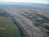
. For much of its upper reaches, the river is braided
Braided river
A braided river is one of a number of channel types and has a channel that consists of a network of small channels separated by small and often temporary islands called braid bars or, in British usage, aits or eyots. Braided streams occur in rivers with high slope and/or large sediment load...
, with wide shingle beds. As the river approaches the Canterbury Plains
Canterbury Plains
The Canterbury Plains are an area in New Zealand centred to the south of the city of Christchurch in the Canterbury Region. Their northern extremes are at the foot of the Hundalee Hills in the Hurunui District, and in the south they merge into the plains of North Otago beyond the Waitaki...
, it passes through a belt of mountains, and is forced into a narrow canyon (the Waimakariri Gorge
Waimakariri Gorge
The Waimakariri Gorge is located on the Waimakariri River in inland Canterbury in the South Island of New Zealand.Like its neighbour, the Rakaia River, the Waimakariri runs through wide shingle beds for much of its length, but is forced through a narrow canyon as it approaches the Canterbury...
), before reverting to its braided form for its passage across the plains. It finally enters the Pacific north of Christchurch, near the town of Kaiapoi
Kaiapoi
Kaiapoi is a town in the Canterbury region of the South Island of New Zealand, located close to the mouth of the Waimakariri River, and approximately 17 kilometres north of Christchurch....
.
Chinook salmon
Chinook salmon
The Chinook salmon, Oncorhynchus tshawytscha, is the largest species in the pacific salmon family. Other commonly used names for the species include King salmon, Quinnat salmon, Spring salmon and Tyee salmon...
(Oncorhynchus tshawytscha) were introduced from California in the 1900s and persist today.
In Māori, Waimakariri has several meanings, one of which is "river of cold rushing water".
In the 1850s European settlers gave the river the name Courtenay River, but it lapsed into disuse.
Geological evidence indicates that the river mouth has been very mobile, at times flowing through the current location of Christchurch and even flowing into Lake Ellesmere
Lake Ellesmere
Lake Ellesmere / Te Waihora is located in the Canterbury Region of the South Island of New Zealand. It is actually a broad, shallow lagoon located directly to the west of Banks Peninsula, separated from the Pacific Ocean by a long narrow sandy spit called Kaitorete Spit, or more correctly Kaitorete...
south of Banks Peninsula
Banks Peninsula
Banks Peninsula is a peninsula of volcanic origin on the east coast of the South Island of New Zealand. It has an area of approximately and encompasses two large harbours and many smaller bays and coves...
for a time.
Instead of being unoccupied crown land as are most New Zealand river beds, the bed of the Waimakariri River is vested in the Canterbury Regional Council (Environment Canterbury).
There are four bridges over the Waimakariri River - three road and one rail. Two of the road bridges and the rail bridge are located just north of Christchurch, while the third road bridge is located inland at the south end of the Waimakariri Gorge.
The river is known colloquially in Canterbury as "The Waimak".
Development
In 1923 the river was investigated for a hydroelectric dam to supply electricity to Christchurch. It received support from the community but the dam was never built since the Government offered inexpensive electricity from the Lake ColeridgeLake Coleridge
Lake Coleridge is located in inland Canterbury, in New Zealand's South Island. Located 35 kilometres to the northwest of Methven, it has a surface area of 47 km²....
scheme.
The Central Plains Water
Central Plains Water
Central Plains Water, or, more fully, the Central Plains Water Enhancement Scheme, is a large-scale proposal for water diversion, damming, reticulation and irrigation for the Central Plains of Canterbury, New Zealand....
Trust is proposing to take 40 cubic metres per second of water from two points on the Waimakariri River as part of the Central Plains Water
Central Plains Water
Central Plains Water, or, more fully, the Central Plains Water Enhancement Scheme, is a large-scale proposal for water diversion, damming, reticulation and irrigation for the Central Plains of Canterbury, New Zealand....
enhancement scheme.