

Avon River, Canterbury
Encyclopedia
The Avon River flows through the centre of the city of Christchurch
, New Zealand
, and out to an estuary
, which it shares with the Heathcote River
, the Avon Heathcote Estuary
.
's rivers, it is very young. The Avon (in its current course) may date from New Zealand's last ice age
.
through Ilam
, Riccarton
and Fendalton
, then through Hagley Park
and the Central Business District
(CBD).
East of the CBD, it passes through Avonside
, Dallington
, Avondale
and Aranui
, and finally flowing into the Pacific Ocean
via the Avon Heathcote Estuary
near Sumner
.
had planned to call it the Shakespere
. The river was given its current name by John Deans in 1848 after the River Avon in Scotland
. The Deans built their homestead adjacent to the Avon River where the suburb of Riccarton
now lies.
The name was officially altered to Avon River / Ōtakaro by the Ngai Tahu Claims Settlement Act 1998, one of many such changes under the Ngāi Tahu
treaty settlement.
as a tourist attraction is available in the central city
, Hagley Park
and Mona Vale, a park in Fendalton
.
, the February 2011 Christchurch earthquake
and the June 2011 Christchurch earthquake
and has been zoned red by the Canterbury Earthquake Recovery Authority
. Community interests are lobbying for the red zoned land to be turned into a park that links the central city with the estuary. The campaign is headed by a group called Avon-Otakaro Network (AvON) and has received the backing of the mayor.
Christchurch
Christchurch is the largest city in the South Island of New Zealand, and the country's second-largest urban area after Auckland. It lies one third of the way down the South Island's east coast, just north of Banks Peninsula which itself, since 2006, lies within the formal limits of...
, New Zealand
New Zealand
New Zealand is an island country in the south-western Pacific Ocean comprising two main landmasses and numerous smaller islands. The country is situated some east of Australia across the Tasman Sea, and roughly south of the Pacific island nations of New Caledonia, Fiji, and Tonga...
, and out to an estuary
Estuary
An estuary is a partly enclosed coastal body of water with one or more rivers or streams flowing into it, and with a free connection to the open sea....
, which it shares with the Heathcote River
Heathcote River
The Heathcote River lies within the city boundaries of Christchurch, New Zealand, and is fed from springs near Templetons Road and also receives wet weather flows from as far west as Pound Road. It meanders around the base of the Port Hills from west to south-east.-Course:The catchment of the...
, the Avon Heathcote Estuary
Avon Heathcote Estuary
The Avon Heathcote Estuary is the largest semi-enclosed shallow estuary in Canterbury and remains one of New Zealand’s most important coastal wetlands. It is well known as an internationally important habitat for migratory birds, and it is an important recreational playground and educational resource...
.
Geology
Geologically, as with most of the South IslandSouth Island
The South Island is the larger of the two major islands of New Zealand, the other being the more populous North Island. It is bordered to the north by Cook Strait, to the west by the Tasman Sea, to the south and east by the Pacific Ocean...
's rivers, it is very young. The Avon (in its current course) may date from New Zealand's last ice age
Ice age
An ice age or, more precisely, glacial age, is a generic geological period of long-term reduction in the temperature of the Earth's surface and atmosphere, resulting in the presence or expansion of continental ice sheets, polar ice sheets and alpine glaciers...
.
Course
The Avon follows a meandering course through Christchurch from its source in the outer western suburb of AvonheadAvonhead
The suburb of Avonhead is located in the city of Christchurch. Avonhead has two primary schools The suburb of Avonhead is located in the city of Christchurch. Avonhead has two primary schools The suburb of Avonhead is located in the city of Christchurch. Avonhead has two primary schools (Avonhead...
through Ilam
Ilam, New Zealand
Ilam is a leafy suburb of Christchurch, New Zealand about five kilometres west of the city centre. It is the location of the University of Canterbury....
, Riccarton
Riccarton, New Zealand
Riccarton is a suburb of Christchurch. It is due west of the city centre, separated from it by Hagley Park. Upper Riccarton is to the west of Riccarton.-History:...
and Fendalton
Fendalton
Fendalton is a suburb of Christchurch, in the South Island of New Zealand.-History:Fendalton was originally known at Fendall Town, named after the original settler of the land, Walpole Cheshire Fendall . Fendall emigrated from Yorkshire in 1850 and took up land north of the Waimairi Stream...
, then through Hagley Park
Hagley Park
Hagley Park is the largest urban open space in Christchurch, New Zealand, and was created in 1855 by the Provincial Government. According to the government's decree at that time, Hagley Park is "reserved forever as a public park, and shall be open for the recreation and enjoyment of the public."...
and the Central Business District
Christchurch Central City
Christchurch Central City is the geographical centre and the heart of Christchurch, New Zealand. It is defined as the area within the four avenues and thus includes the densely built up central city, some less dense surrounding areas of residential, educational and industrial usage, and green...
(CBD).
East of the CBD, it passes through Avonside
Avonside
Avonside is an eastern suburb in Christchurch, New Zealand. It is one of the oldest suburbs of the city, with only Heathcote being older.-History:...
, Dallington
Dallington, New Zealand
Dallington is a suburb of Christchurch, New Zealand, on the north-east side of the city.It is bounded mainly by the Avon river, stretching in a circular area from the intersection of Gayhurst Road, Dallington Terrace and Locksley Avenue along to New Brighton Road, North Parade and Banks Avenue...
, Avondale
Avondale, Canterbury
Avondale is a suburb of Christchurch in the South Island of New Zealand. It is located northeast of the city centre, and is close to the Avon River, four kilometres to the northwest of its estuary...
and Aranui
Aranui
Aranui 3 is a mixed passenger/cargo vessel operating between Tahiti and the Marquesas. With a homeport of Papeete, French Polynesia, Aranui 3 is registered as a passenger ship under the International Convention for the Safety of Life at Sea , for international operation.She was built in Romania...
, and finally flowing into the Pacific Ocean
Pacific Ocean
The Pacific Ocean is the largest of the Earth's oceanic divisions. It extends from the Arctic in the north to the Southern Ocean in the south, bounded by Asia and Australia in the west, and the Americas in the east.At 165.2 million square kilometres in area, this largest division of the World...
via the Avon Heathcote Estuary
Avon Heathcote Estuary
The Avon Heathcote Estuary is the largest semi-enclosed shallow estuary in Canterbury and remains one of New Zealand’s most important coastal wetlands. It is well known as an internationally important habitat for migratory birds, and it is an important recreational playground and educational resource...
near Sumner
Sumner, New Zealand
Sumner is a coastal seaside suburb of Christchurch, New Zealand and was surveyed and named in 1849 in honour of John Bird Sumner, the then newly appointed Archbishop of Canterbury and president of the Canterbury Association...
.
Naming
The Avon River was known by the Māori as Ōtākaro or Putare Kamutu). The Canterbury AssociationCanterbury Association
The Canterbury Association was formed in order to establish a colony in what is now the Canterbury Region in the South Island of New Zealand.- Formation of the Association :...
had planned to call it the Shakespere
William Shakespeare
William Shakespeare was an English poet and playwright, widely regarded as the greatest writer in the English language and the world's pre-eminent dramatist. He is often called England's national poet and the "Bard of Avon"...
. The river was given its current name by John Deans in 1848 after the River Avon in Scotland
Scotland
Scotland is a country that is part of the United Kingdom. Occupying the northern third of the island of Great Britain, it shares a border with England to the south and is bounded by the North Sea to the east, the Atlantic Ocean to the north and west, and the North Channel and Irish Sea to the...
. The Deans built their homestead adjacent to the Avon River where the suburb of Riccarton
Riccarton, New Zealand
Riccarton is a suburb of Christchurch. It is due west of the city centre, separated from it by Hagley Park. Upper Riccarton is to the west of Riccarton.-History:...
now lies.
The name was officially altered to Avon River / Ōtakaro by the Ngai Tahu Claims Settlement Act 1998, one of many such changes under the Ngāi Tahu
Ngāi Tahu
Ngāi Tahu, or Kāi Tahu, is the principal Māori iwi of the southern region of New Zealand, with the tribal authority, Te Rūnanga o Ngāi Tahu, being based in Christchurch and Invercargill. The iwi combines three groups, Kāi Tahu itself, and Waitaha and Kāti Mamoe who lived in the South Island prior...
treaty settlement.
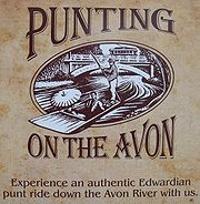
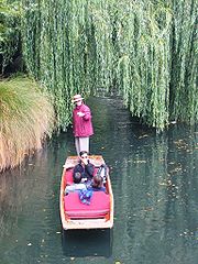
Punting
Commercial puntingPunt (boat)
A punt is a flat-bottomed boat with a square-cut bow, designed for use in small rivers or other shallow water. Punting refers to boating in a punt. The punter generally propels the punt by pushing against the river bed with a pole...
as a tourist attraction is available in the central city
Christchurch Central City
Christchurch Central City is the geographical centre and the heart of Christchurch, New Zealand. It is defined as the area within the four avenues and thus includes the densely built up central city, some less dense surrounding areas of residential, educational and industrial usage, and green...
, Hagley Park
Hagley Park
Hagley Park is the largest urban open space in Christchurch, New Zealand, and was created in 1855 by the Provincial Government. According to the government's decree at that time, Hagley Park is "reserved forever as a public park, and shall be open for the recreation and enjoyment of the public."...
and Mona Vale, a park in Fendalton
Fendalton
Fendalton is a suburb of Christchurch, in the South Island of New Zealand.-History:Fendalton was originally known at Fendall Town, named after the original settler of the land, Walpole Cheshire Fendall . Fendall emigrated from Yorkshire in 1850 and took up land north of the Waimairi Stream...
.
Earthquakes
Much of the land along the Avon River downstream from the central city was damaged in the 2010 Canterbury earthquake2010 Canterbury earthquake
The 2010 Canterbury earthquake was a 7.1 magnitude earthquake, which struck the South Island of New Zealand at 4:35 am on local time ....
, the February 2011 Christchurch earthquake
2011 Christchurch earthquake
The February 2011 Christchurch earthquake was a magnitude 6.3 earthquake that struck the Canterbury region in New Zealand's South Island at on local time , The earthquake was centred west of the town of Lyttelton, and south-east of the centre of Christchurch, New Zealand's second-most populous...
and the June 2011 Christchurch earthquake
June 2011 Christchurch earthquake
The June 2011 Christchurch earthquake was a shallow magnitude 6.3 ML earthquake that occurred on 13 June 2011 at 14:20 NZST . It was centred at a depth of 6.0 km , about 13 km from Christchurch, which had previously been devastated by the February 2011 magnitude 6.3 ML earthquake...
and has been zoned red by the Canterbury Earthquake Recovery Authority
Canterbury Earthquake Recovery Authority
The Canterbury Earthquake Recovery Authority is a public service department established by the New Zealand government to coordinate the rebuilding of Christchurch and the surrounding areas following the 22 February 2011 earthquake.-Description:...
. Community interests are lobbying for the red zoned land to be turned into a park that links the central city with the estuary. The campaign is headed by a group called Avon-Otakaro Network (AvON) and has received the backing of the mayor.
External links
- Avon River Masterplan, Christchurch City Council