

Palouse
Encyclopedia
The Palouse is a region of the northwestern
United States
, encompassing parts of southeastern
Washington, north central
Idaho
and, in some definitions, extending south into northeast Oregon
. It is a major agricultural
area, primarily producing wheat
and legumes. Situated about 160 miles (250 kilometers) north of the Oregon Trail
, the region experienced rapid growth in the late 19th century, for a brief time surpassed the population of the Puget Sound
region of Washington. The region is home to two land grant universities
, the University of Idaho
in Moscow
and Washington State University
in Pullman
. Located just eight miles (13 km) apart, both schools opened in the early 1890s.

 The origin of the name "Palouse" is unclear. One theory is that the name of the Palus
tribe (spelled in early accounts variously Palus, Palloatpallah, Pelusha, et al.) was converted by French-Canadian fur traders to the more familiar French word pelouse, meaning "land with short and thick grass" or "lawn." Over time, the spelling changed to Palouse. Another theory is that the name was in the first place a French word, describing the area which was then applied to the indigenous people inhabiting it.
Traditionally, the Palouse region was defined as the fertile hills and prairies north of the Snake River
, which separated it from Walla Walla Country, and north of the Clearwater River
, which separated it from the Camas Prairie
, extending north along the Washington and Idaho border, south of Spokane
, centered on the Palouse River
. This region underwent a settlement and wheat-growing boom during the 1880s, part of a larger process of growing wheat in southeast Washington, originally pioneered in the Walla Walla Country south of the Snake River.
While this definition of the Palouse remains common today, sometimes the term is used to refer to the entire wheat-growing region, including the Walla Walla Country, the Camas Prairie of Idaho, the Big Bend region of the central Columbia River Plateau
, and other smaller agricultural districts such as Asotin County, Washington, and Umatilla County
, Oregon. This larger definition is used by organizations such as the World Wide Fund for Nature
, who define the Palouse Grasslands ecoregion
broadly.
The community of Palouse
, Washington, is located in Whitman County, about 7 miles (11 km) west of Potlach
, Idaho.
Nevertheless, the traditional definition of the Palouse region is distinct from the older Walla Walla region south of the Snake River, where dryland farming
of wheat was first proved viable in the region in the 1860s. During the 1870s, the Walla Walla region was rapidly converted to farmland, while the initial experiments in growing wheat began in the Palouse region, which previously had been the domain of cattle and sheep ranching. When those trials proved more than successful, a minor land rush quickly filled the Palouse region with farmers during the 1880s. The simultaneous proliferation of railroads only increased the rapid settlement of the Palouse. By 1890 nearly all the Palouse lands had been taken up and converted to wheat farming.
Unlike the Walla Walla Country, which was solidly anchored on the city of Walla Walla
, the Palouse region saw the rise of at least four centers, all within several miles of each other: Colfax
(the oldest), Palouse
, Pullman
, and on the Idaho side, Moscow
. These four centers, along with at least ten lesser ones, resulted in a diffused urban pattern, relative to the centralized Walla Walla country.
Cities along the borders of the Palouse, in some definitions included within the Palouse region, include Lewiston
, Idaho, serving the Camas Prairie farmlands, Ritzville
, serving the eastern edge of the Big Bend Country, and Spokane
, the major urban hub of the entire region. So dominant was Spokane's position, it became known as the capital of the Inland Empire
, including all the wheat producing regions, the local mining districts, and lumber producing forests. Spokane also served as the main railroad and transportation hub of the entire region.
By 1910, although local terms like Palouse, Walla Walla Country, Big Bend, Umatilla Country, and Camas Prairie, continued to be common, many people of the region began to regard themselves as living in the Inland Empire
, the Wheat Belt, the Columbia Basin
, or simply Eastern Washington, Oregon, or North Idaho.
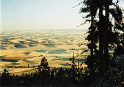
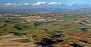 The peculiar and picturesque silt dunes which characterize the Palouse Prairie were formed during the ice age
s (Alt and Hyndman 1989). Blown in from the glacial outwash
plains to the west and south, the Palouse hills consist of more or less random humps and hollows. The steepest slopes, which may reach 50% slope, face the northeast. The highly productive loess
ranges from 5 to 130 cm deep. Large areas of level land are rare.
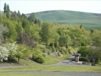
Higher elevation
s bordering the prairies such as the Palouse Range support an often dense coniferous forest. Moscow Mountain is the tallest of the range, 4983 feet (1519 m) above sea level; it is located eight miles (13 km) northeast of the city of Moscow.
had been invented and was in use, but few farmers had enough horses to pull such a machine, which required a crew of 40 horses and six men to operate on level ground. Because of this, use of combines on the Palouse lagged behind use in other farming communities in the United States.
It was only when the Idaho Harvester Company in Moscow
began to manufacture a smaller machine that combine harvesting became feasible. By 1930, 90% of all Palouse wheat was harvested using combines.
The next step in mechanization was development of the tractor
. As with the combines, the first steam engine and gasoline-powered tractors were too heavy and awkward for use on the steep Palouse hills. The smaller, general use tractors introduced in the 1920s were only marginally used. As a result, by 1930, only 20% of Palouse farmers used tractors.
Today, the Palouse region is the most important lentil
-growing region in the USA.
(Agropyron spicatum) and Idaho fescue
(Festuca idahoensis), today virtually all of the Palouse Prairie is planted in agricultural crops. The native prairie is one of the most endangered ecosystems in the United States (Noss et al. 1995), as only a little over one percent of the original prairie still exists.
People have taken their toll on wildlife. Birds and small mammals, once abundant, are now few. The intensive roadbed-to-roadbed farming currently practiced across the Palouse leaves few fences and fewer fencerows. Many intermittent streams have been plowed over; many perennial streams with large wet meadows adjacent to them are now intermittent or deeply incised.
Riparian areas offer breeding habitat for a greater diversity of bird
s than any other habitat in the U.S. (Ratti and Scott 1991). Loss of trees and shrubs along stream corridors means fewer birds and eventually fewer species. The majority of riparian areas have been lost across the bioregion.
 Lately, conversion of agricultural lands to suburban homesites on large plots invites a new suite of biodiversity onto the Palouse Prairie. University of Idaho
wildlife professor J. Ratti documented changes in bird community composition over a 10 year period as he converted a wheat field into a suburban wildlife refuge. As of 1991, his 15 acres (60,702.9 m²) yard attracted 86 species of birds, an increase from 18 (Ratti and Scott 1991).
Intensification of agriculture has affected both water quantity and quality. Agriculture has changed the hydrograph, increasing peak runoff flows and shortening the length of runoff. The result is more intense erosion and loss of perennial prairie streams. As early as the 1930s soil scientists were noting significant downcutting
of regional rivers (Victor 1935) and expansion of channel width. Higher faster runoff caused streams to downcut quickly, effectively lowering the water table in immediately adjacent meadows. On the South Palouse River, this process was so efficient that by 1900 farming was possible where it had been too wet previously (Victor 1935). Replacement of perennial grasses with annual crops resulted in more overland flow and less infiltration, which translates at a watershed level to higher peak flows that subside more quickly than in the past. Once perennial prairie streams are now often dry by mid-summer. This has undoubtedly influenced the amphibious and aquatic species.
As population grew, towns and cities appeared changing the complexion of the area. By 1910, there were 22,000 people scattered in 30 communities across the Palouse Prairie.
Crop production increased dramatically (200 - 400%) after the introduction of fertilizer following World War II
.
Since 1900, 94% of the grasslands and 97% of the wetlands in the Palouse ecoregion have been converted to crop, hay, or pasture lands. Approximately 63% of the lands in forest cover in 1900 are still forested, 9% are grass, and 7% are regenerating forestlands or shrublands. The remaining 21% of previously forested lands have been converted to agriculture or urban areas.
 The impacts of domestic grazers on the grasslands of the Palouse and Camas Prairies was transitory because much of the areas were rapidly converted to agriculture. However, the canyonlands of the Snake
and Clearwater
Rivers and their tributaries with their much shallower soils, steep topography, and hotter, drier climate, were largely unsuitable for crop production and were consequently used for a much longer period by grazing domestic animals (Tisdale 1986). There, intense grazing and other disturbances have resulted in irreversible changes with the native grasses largely replaced by annual grasses of the genus Bromus
and noxious weeds, particularly from the genus Centaurea
. The highly competitive plants of both of these genera evolved under similar climatic regimes in Eurasia and were introduced to the U.S. in the late 19th century.
s are generally less frequent today than in the past, primarily due to fire suppression, construction of roads (which serve as barriers to fire spread) and conversion of grass and forests to cropland (Morgan et al. 1996). Historians recount lightning-ignited fires burning in the pine fringes bordering the prairies in late autumn, but the extent to which forest fires spread into the prairie or the converse is not known. Some fire ecologists believe the Nez Perce burned the Palouse and Camas Prairies to encourage growth of Camas
(Morgan, pers. Comm); but there is little historical record to solve the mystery. European-American settlers used fire to clear land for settlement and grazing until the 1930s. Since then, forest fires have become less common. One result has been increasing tree density on forested lands and encroachment of shrubs and trees into previously open areas. Consequently, when fires occur in the forest, they are more likely to result in mixed severity or stand replacing events.
Northwestern United States
The Northwestern United States comprise the northwestern states up to the western Great Plains regions of the United States, and consistently include the states of Oregon, Washington, Idaho, Montana, Wyoming, to which part of southeast Alaska is also sometimes included...
United States
United States
The United States of America is a federal constitutional republic comprising fifty states and a federal district...
, encompassing parts of southeastern
Eastern Washington
Eastern Washington is the portion of the U.S. state of Washington east of the Cascade Range. The region contains the city of Spokane , the Tri-Cities, the Columbia River and the Grand Coulee Dam, the Hanford Nuclear Reservation and the fertile farmlands of the Yakima Valley and the...
Washington, north central
North Central Idaho
North Central Idaho is an area which spans the central part of the state of Idaho and borders Oregon, Montana, and Washington. It is the southern half of the Idaho Panhandle region and is rich in agriculture and natural resources. Lewis and Clark travelled throughout this area on their journey to...
Idaho
Idaho
Idaho is a state in the Rocky Mountain area of the United States. The state's largest city and capital is Boise. Residents are called "Idahoans". Idaho was admitted to the Union on July 3, 1890, as the 43rd state....
and, in some definitions, extending south into northeast Oregon
Oregon
Oregon is a state in the Pacific Northwest region of the United States. It is located on the Pacific coast, with Washington to the north, California to the south, Nevada on the southeast and Idaho to the east. The Columbia and Snake rivers delineate much of Oregon's northern and eastern...
. It is a major agricultural
Agriculture
Agriculture is the cultivation of animals, plants, fungi and other life forms for food, fiber, and other products used to sustain life. Agriculture was the key implement in the rise of sedentary human civilization, whereby farming of domesticated species created food surpluses that nurtured the...
area, primarily producing wheat
Wheat
Wheat is a cereal grain, originally from the Levant region of the Near East, but now cultivated worldwide. In 2007 world production of wheat was 607 million tons, making it the third most-produced cereal after maize and rice...
and legumes. Situated about 160 miles (250 kilometers) north of the Oregon Trail
Oregon Trail
The Oregon Trail is a historic east-west wagon route that connected the Missouri River to valleys in Oregon and locations in between.After 1840 steam-powered riverboats and steamboats traversing up and down the Ohio, Mississippi and Missouri rivers sped settlement and development in the flat...
, the region experienced rapid growth in the late 19th century, for a brief time surpassed the population of the Puget Sound
Puget Sound
Puget Sound is a sound in the U.S. state of Washington. It is a complex estuarine system of interconnected marine waterways and basins, with one major and one minor connection to the Strait of Juan de Fuca and the Pacific Ocean — Admiralty Inlet being the major connection and...
region of Washington. The region is home to two land grant universities
Land-grant university
Land-grant universities are institutions of higher education in the United States designated by each state to receive the benefits of the Morrill Acts of 1862 and 1890....
, the University of Idaho
University of Idaho
The University of Idaho is the State of Idaho's flagship and oldest public university, located in the rural city of Moscow in Latah County in the northern portion of the state...
in Moscow
Moscow, Idaho
Moscow is a city in northern Idaho, situated along the Washington/Idaho border. It is the most populous city and county seat of Latah County and the home of the University of Idaho, the land grant institution and primary research university for the state...
and Washington State University
Washington State University
Washington State University is a public research university based in Pullman, Washington, in the Palouse region of the Pacific Northwest. Founded in 1890, WSU is the state's original and largest land-grant university...
in Pullman
Pullman, Washington
Pullman is the largest city in Whitman County, Washington, United States. The population was 24,675 at the 2000 census and 29,799 according to the 2010 census...
. Located just eight miles (13 km) apart, both schools opened in the early 1890s.
Geography and History
Palus (tribe)
The Palus are a Sahaptin tribe recognized in the Treaty of 1855 with the Yakamas . A variant spelling is Palouse, which was the source of the name for the fertile prairie of Washington and Idaho.- Ethnography :...
tribe (spelled in early accounts variously Palus, Palloatpallah, Pelusha, et al.) was converted by French-Canadian fur traders to the more familiar French word pelouse, meaning "land with short and thick grass" or "lawn." Over time, the spelling changed to Palouse. Another theory is that the name was in the first place a French word, describing the area which was then applied to the indigenous people inhabiting it.
Traditionally, the Palouse region was defined as the fertile hills and prairies north of the Snake River
Snake River
The Snake is a major river of the greater Pacific Northwest in the United States. At long, it is the largest tributary of the Columbia River, the largest North American river that empties into the Pacific Ocean...
, which separated it from Walla Walla Country, and north of the Clearwater River
Clearwater River (Idaho)
The Clearwater River is a river in north central Idaho, which flows westward from the Bitterroot Mountains along the Idaho-Montana border, and joins the Snake River at Lewiston. In October 1805, the Lewis and Clark Expedition descended the Clearwater River in dugout canoes, putting in at "Canoe...
, which separated it from the Camas Prairie
Camas prairie
The name camas prairie refers to several distinct geographical areas in the western United States which were named for the native perennial camassia or camas, including regions in the states of Idaho, Montana, Oregon and Washington...
, extending north along the Washington and Idaho border, south of Spokane
Spokane, Washington
Spokane is a city located in the Northwestern United States in the state of Washington. It is the largest city of Spokane County of which it is also the county seat, and the metropolitan center of the Inland Northwest region...
, centered on the Palouse River
Palouse River
The Palouse River is a tributary of the Snake River located in the U.S. states of Washington and Idaho. It flows for southwestwards, primarily through the Palouse region of southeastern Washington...
. This region underwent a settlement and wheat-growing boom during the 1880s, part of a larger process of growing wheat in southeast Washington, originally pioneered in the Walla Walla Country south of the Snake River.
While this definition of the Palouse remains common today, sometimes the term is used to refer to the entire wheat-growing region, including the Walla Walla Country, the Camas Prairie of Idaho, the Big Bend region of the central Columbia River Plateau
Columbia River Plateau
The Columbia Plateau is a geologic and geographic region that lies across parts of the U.S. states of Washington, Oregon, and Idaho. It is a wide flood basalt plateau between the Cascade Range and the Rocky Mountains, cut through by the Columbia River...
, and other smaller agricultural districts such as Asotin County, Washington, and Umatilla County
Umatilla County, Oregon
Umatilla County is a county located in the U.S. state of Oregon. It is included in the 8 county definition of Eastern Oregon. The county is named for the Umatilla River. In 2010, its population was 75,889...
, Oregon. This larger definition is used by organizations such as the World Wide Fund for Nature
World Wide Fund for Nature
The World Wide Fund for Nature is an international non-governmental organization working on issues regarding the conservation, research and restoration of the environment, formerly named the World Wildlife Fund, which remains its official name in Canada and the United States...
, who define the Palouse Grasslands ecoregion
Ecoregion
An ecoregion , sometimes called a bioregion, is an ecologically and geographically defined area that is smaller than an ecozone and larger than an ecosystem. Ecoregions cover relatively large areas of land or water, and contain characteristic, geographically distinct assemblages of natural...
broadly.
The community of Palouse
Palouse, Washington
Palouse is a city in Whitman County, Washington, United States. The population was 998 at the 2010 census. Palouse is named for the region of farmland in which it is situated, and was incorporated in 1888.-History:...
, Washington, is located in Whitman County, about 7 miles (11 km) west of Potlach
Potlatch, Idaho
Potlatch is a city in Latah County, Idaho, United States. The population was 791 at the 2000 census.-History:Potlatch was founded in 1905 as a company town by the Potlach Corporation. The townsite was chosen because of proximity to Potlatch Corporation's large holdings of western white pine on the...
, Idaho.
Nevertheless, the traditional definition of the Palouse region is distinct from the older Walla Walla region south of the Snake River, where dryland farming
Dryland farming
Dryland farming is an agricultural technique for non-irrigated cultivation of drylands.-Locations:Dryland farming is used in the Great Plains, the Palouse plateau of Eastern Washington, and other arid regions of North America, the Middle East and in other grain growing regions such as the steppes...
of wheat was first proved viable in the region in the 1860s. During the 1870s, the Walla Walla region was rapidly converted to farmland, while the initial experiments in growing wheat began in the Palouse region, which previously had been the domain of cattle and sheep ranching. When those trials proved more than successful, a minor land rush quickly filled the Palouse region with farmers during the 1880s. The simultaneous proliferation of railroads only increased the rapid settlement of the Palouse. By 1890 nearly all the Palouse lands had been taken up and converted to wheat farming.
Unlike the Walla Walla Country, which was solidly anchored on the city of Walla Walla
Walla Walla, Washington
Walla Walla is the largest city in and the county seat of Walla Walla County, Washington, United States. The population was 31,731 at the 2010 census...
, the Palouse region saw the rise of at least four centers, all within several miles of each other: Colfax
Colfax, Washington
Colfax is the county seat of Whitman County, Washington, United States.The population was 2,805 at the 2010 census.It is situated amidst wheat-covered hills in a valley at the confluence of the north and south forks of the Palouse River. U.S...
(the oldest), Palouse
Palouse, Washington
Palouse is a city in Whitman County, Washington, United States. The population was 998 at the 2010 census. Palouse is named for the region of farmland in which it is situated, and was incorporated in 1888.-History:...
, Pullman
Pullman, Washington
Pullman is the largest city in Whitman County, Washington, United States. The population was 24,675 at the 2000 census and 29,799 according to the 2010 census...
, and on the Idaho side, Moscow
Moscow, Idaho
Moscow is a city in northern Idaho, situated along the Washington/Idaho border. It is the most populous city and county seat of Latah County and the home of the University of Idaho, the land grant institution and primary research university for the state...
. These four centers, along with at least ten lesser ones, resulted in a diffused urban pattern, relative to the centralized Walla Walla country.
Cities along the borders of the Palouse, in some definitions included within the Palouse region, include Lewiston
Lewiston, Idaho
Lewiston is a city in and also the county seat of Nez Perce County in the Pacific Northwest state of Idaho. It is the second-largest city in the northern Idaho region, behind Coeur d'Alene and ninth-largest in the state. Lewiston is the principal city of the Lewiston, ID - Clarkston, WA...
, Idaho, serving the Camas Prairie farmlands, Ritzville
Ritzville, Washington
Ritzville is a city in Adams County, Washington, United States. The population was 1,673 at the 2010 census. It is the county seat of Adams County.-History:...
, serving the eastern edge of the Big Bend Country, and Spokane
Spokane, Washington
Spokane is a city located in the Northwestern United States in the state of Washington. It is the largest city of Spokane County of which it is also the county seat, and the metropolitan center of the Inland Northwest region...
, the major urban hub of the entire region. So dominant was Spokane's position, it became known as the capital of the Inland Empire
Inland Empire (Pacific Northwest)
thumb|The Inland Empire regionThe Inland Northwest, or Inland Empire, is a region in the Pacific Northwest centered on Spokane, Washington, including the surrounding Columbia River basin and all of North Idaho....
, including all the wheat producing regions, the local mining districts, and lumber producing forests. Spokane also served as the main railroad and transportation hub of the entire region.
By 1910, although local terms like Palouse, Walla Walla Country, Big Bend, Umatilla Country, and Camas Prairie, continued to be common, many people of the region began to regard themselves as living in the Inland Empire
Inland Empire (Pacific Northwest)
thumb|The Inland Empire regionThe Inland Northwest, or Inland Empire, is a region in the Pacific Northwest centered on Spokane, Washington, including the surrounding Columbia River basin and all of North Idaho....
, the Wheat Belt, the Columbia Basin
Columbia Basin
The Columbia Basin, the drainage basin of the Columbia River, occupies a large area–about —of the Pacific Northwest region of North America. In common usage, the term often refers to a smaller area, generally the portion of the drainage basin that lies within eastern Washington.Usage of the term...
, or simply Eastern Washington, Oregon, or North Idaho.
Geology
Ice age
An ice age or, more precisely, glacial age, is a generic geological period of long-term reduction in the temperature of the Earth's surface and atmosphere, resulting in the presence or expansion of continental ice sheets, polar ice sheets and alpine glaciers...
s (Alt and Hyndman 1989). Blown in from the glacial outwash
Sandur
A sandur is a glacial outwash plain formed of sediments deposited by meltwater at the terminus of a glacier.- Formation :Sandar are found in glaciated areas, such as Svalbard, Kerguelen Islands, and Iceland...
plains to the west and south, the Palouse hills consist of more or less random humps and hollows. The steepest slopes, which may reach 50% slope, face the northeast. The highly productive loess
Loess
Loess is an aeolian sediment formed by the accumulation of wind-blown silt, typically in the 20–50 micrometre size range, twenty percent or less clay and the balance equal parts sand and silt that are loosely cemented by calcium carbonate...
ranges from 5 to 130 cm deep. Large areas of level land are rare.
Higher elevation
Elevation
The elevation of a geographic location is its height above a fixed reference point, most commonly a reference geoid, a mathematical model of the Earth's sea level as an equipotential gravitational surface ....
s bordering the prairies such as the Palouse Range support an often dense coniferous forest. Moscow Mountain is the tallest of the range, 4983 feet (1519 m) above sea level; it is located eight miles (13 km) northeast of the city of Moscow.
Farming
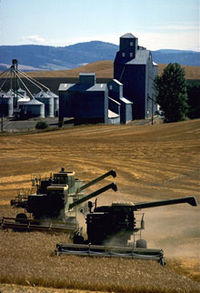
Early farming was extremely labor-intensive and relied heavily on human and horse-power. An organized harvesting/threshing team in the 1920s required 120 men and 320 mules and horses. Teams moved from farm to farm as the crops ripened. By this point, the combineCombine harvester
The combine harvester, or simply combine, is a machine that harvests grain crops. The name derives from the fact that it combines three separate operations, reaping, threshing, and winnowing, into a single process. Among the crops harvested with a combine are wheat, oats, rye, barley, corn ,...
had been invented and was in use, but few farmers had enough horses to pull such a machine, which required a crew of 40 horses and six men to operate on level ground. Because of this, use of combines on the Palouse lagged behind use in other farming communities in the United States.
It was only when the Idaho Harvester Company in Moscow
Moscow, Idaho
Moscow is a city in northern Idaho, situated along the Washington/Idaho border. It is the most populous city and county seat of Latah County and the home of the University of Idaho, the land grant institution and primary research university for the state...
began to manufacture a smaller machine that combine harvesting became feasible. By 1930, 90% of all Palouse wheat was harvested using combines.
The next step in mechanization was development of the tractor
Tractor
A tractor is a vehicle specifically designed to deliver a high tractive effort at slow speeds, for the purposes of hauling a trailer or machinery used in agriculture or construction...
. As with the combines, the first steam engine and gasoline-powered tractors were too heavy and awkward for use on the steep Palouse hills. The smaller, general use tractors introduced in the 1920s were only marginally used. As a result, by 1930, only 20% of Palouse farmers used tractors.
 |
Today, the Palouse region is the most important lentil
Lentil
The lentil is an edible pulse. It is a bushy annual plant of the legume family, grown for its lens-shaped seeds...
-growing region in the USA.
Environment
Once an extensive prairie composed of mid-length perennial grasses such as Bluebunch wheatgrassBluebunch wheatgrass
Pseudoroegneria spicata is a species of grass known by the common name Bluebunch Wheatgrass. This native western North American perennial bunchgrass is known by the scientific synonyms Elymus spicatus and Agropyron spicatum. The grass can be found from Alaska to Texas. It occurs in many types of...
(Agropyron spicatum) and Idaho fescue
Festuca idahoensis
Festuca idahoensis is a species of grass known by the common names Idaho fescue and blue bunchgrass. It is native to western North America, where it is widespread and common...
(Festuca idahoensis), today virtually all of the Palouse Prairie is planted in agricultural crops. The native prairie is one of the most endangered ecosystems in the United States (Noss et al. 1995), as only a little over one percent of the original prairie still exists.
People have taken their toll on wildlife. Birds and small mammals, once abundant, are now few. The intensive roadbed-to-roadbed farming currently practiced across the Palouse leaves few fences and fewer fencerows. Many intermittent streams have been plowed over; many perennial streams with large wet meadows adjacent to them are now intermittent or deeply incised.
Riparian areas offer breeding habitat for a greater diversity of bird
Bird
Birds are feathered, winged, bipedal, endothermic , egg-laying, vertebrate animals. Around 10,000 living species and 188 families makes them the most speciose class of tetrapod vertebrates. They inhabit ecosystems across the globe, from the Arctic to the Antarctic. Extant birds range in size from...
s than any other habitat in the U.S. (Ratti and Scott 1991). Loss of trees and shrubs along stream corridors means fewer birds and eventually fewer species. The majority of riparian areas have been lost across the bioregion.
University of Idaho
The University of Idaho is the State of Idaho's flagship and oldest public university, located in the rural city of Moscow in Latah County in the northern portion of the state...
wildlife professor J. Ratti documented changes in bird community composition over a 10 year period as he converted a wheat field into a suburban wildlife refuge. As of 1991, his 15 acres (60,702.9 m²) yard attracted 86 species of birds, an increase from 18 (Ratti and Scott 1991).
Intensification of agriculture has affected both water quantity and quality. Agriculture has changed the hydrograph, increasing peak runoff flows and shortening the length of runoff. The result is more intense erosion and loss of perennial prairie streams. As early as the 1930s soil scientists were noting significant downcutting
Downcutting
Downcutting, also called erosional downcutting or downward erosion or vertical erosion is a geological process that deepens the channel of a stream or valley by removing material from the stream's bed or the valley's floor. How fast downcutting occurs depends on the stream's base level, which is...
of regional rivers (Victor 1935) and expansion of channel width. Higher faster runoff caused streams to downcut quickly, effectively lowering the water table in immediately adjacent meadows. On the South Palouse River, this process was so efficient that by 1900 farming was possible where it had been too wet previously (Victor 1935). Replacement of perennial grasses with annual crops resulted in more overland flow and less infiltration, which translates at a watershed level to higher peak flows that subside more quickly than in the past. Once perennial prairie streams are now often dry by mid-summer. This has undoubtedly influenced the amphibious and aquatic species.
As population grew, towns and cities appeared changing the complexion of the area. By 1910, there were 22,000 people scattered in 30 communities across the Palouse Prairie.
Crop production increased dramatically (200 - 400%) after the introduction of fertilizer following World War II
World War II
World War II, or the Second World War , was a global conflict lasting from 1939 to 1945, involving most of the world's nations—including all of the great powers—eventually forming two opposing military alliances: the Allies and the Axis...
.
Since 1900, 94% of the grasslands and 97% of the wetlands in the Palouse ecoregion have been converted to crop, hay, or pasture lands. Approximately 63% of the lands in forest cover in 1900 are still forested, 9% are grass, and 7% are regenerating forestlands or shrublands. The remaining 21% of previously forested lands have been converted to agriculture or urban areas.
Snake River
The Snake is a major river of the greater Pacific Northwest in the United States. At long, it is the largest tributary of the Columbia River, the largest North American river that empties into the Pacific Ocean...
and Clearwater
Clearwater River (Idaho)
The Clearwater River is a river in north central Idaho, which flows westward from the Bitterroot Mountains along the Idaho-Montana border, and joins the Snake River at Lewiston. In October 1805, the Lewis and Clark Expedition descended the Clearwater River in dugout canoes, putting in at "Canoe...
Rivers and their tributaries with their much shallower soils, steep topography, and hotter, drier climate, were largely unsuitable for crop production and were consequently used for a much longer period by grazing domestic animals (Tisdale 1986). There, intense grazing and other disturbances have resulted in irreversible changes with the native grasses largely replaced by annual grasses of the genus Bromus
Bromus
Bromus is a large genus of the grass family . Estimates in the scientific literature of the number of species have ranged from 100 to 400, but plant taxonomists currently recognize around 160–170 species...
and noxious weeds, particularly from the genus Centaurea
Centaurea
Centaurea is a genus of between 350 and 600 species of herbaceous thistle-like flowering plants in the family Asteraceae. Members of the genus are found only north of the equator, mostly in the Eastern Hemisphere; the Middle East and surrounding regions are particularly species-rich...
. The highly competitive plants of both of these genera evolved under similar climatic regimes in Eurasia and were introduced to the U.S. in the late 19th century.
Fires
While there is some debate over how frequently the Palouse prairie burned historically, there is consensus that fireFire
Fire is the rapid oxidation of a material in the chemical process of combustion, releasing heat, light, and various reaction products. Slower oxidative processes like rusting or digestion are not included by this definition....
s are generally less frequent today than in the past, primarily due to fire suppression, construction of roads (which serve as barriers to fire spread) and conversion of grass and forests to cropland (Morgan et al. 1996). Historians recount lightning-ignited fires burning in the pine fringes bordering the prairies in late autumn, but the extent to which forest fires spread into the prairie or the converse is not known. Some fire ecologists believe the Nez Perce burned the Palouse and Camas Prairies to encourage growth of Camas
Camassia
Camassia is a genus of six species native to western North America, from southern British Columbia to northern California, and east to Utah, Wyoming and Montana...
(Morgan, pers. Comm); but there is little historical record to solve the mystery. European-American settlers used fire to clear land for settlement and grazing until the 1930s. Since then, forest fires have become less common. One result has been increasing tree density on forested lands and encroachment of shrubs and trees into previously open areas. Consequently, when fires occur in the forest, they are more likely to result in mixed severity or stand replacing events.
See also
- Spokane-Coeur d'Alene-Paloos WarSpokane-Coeur d'Alene-Paloos WarThe Coeur d'Alene War of 1858 was the second phase of the Yakima War, involving a series of encounters between the allied Coeur d’Alene, Spokane, Palouse and Northern Paiute against United States Army forces in the Washington and Idaho areas....
(Palouse War) - Palus (tribe)Palus (tribe)The Palus are a Sahaptin tribe recognized in the Treaty of 1855 with the Yakamas . A variant spelling is Palouse, which was the source of the name for the fertile prairie of Washington and Idaho.- Ethnography :...
- AppaloosaAppaloosaThe Appaloosa is a horse breed best known for its colorful leopard-spotted coat pattern. There is a wide range of body types within the breed, stemming from the influence of multiple breeds of horses throughout its history. Each horse's color pattern is genetically the result of various spotting...
External links
News from Palouse- The Eagle & Boomerang! - Local newspaper
- Palouse grasslands (World Wildlife Fund)
- Dept. of Horticulture and Landscape Architecture, Washington State University
- Palouse grasslands images at bioimages.vanderbilt.edu (slow modem version)
- Palouse River, The Columbia Gazetteer of North America. 2000.
- National Lentil Festival
- The Appaloosa Museum