

Overdeepening
Encyclopedia
Thalweg
Thalweg in geography and fluvial geomorphology signifies the deepest continuous inline within a valley or watercourse system.-Hydrology:In hydrological and fluvial landforms, the thalweg is a line drawn to join the lowest points along the entire length of a stream bed or valley in its downward...
) along a valley or watercourse. This phenomenon is observed under modern day glaciers, in salt-water fjord
Fjord
Geologically, a fjord is a long, narrow inlet with steep sides or cliffs, created in a valley carved by glacial activity.-Formation:A fjord is formed when a glacier cuts a U-shaped valley by abrasion of the surrounding bedrock. Glacial melting is accompanied by rebound of Earth's crust as the ice...
s and fresh-water lakes remaining after glaciers melt, as well as in tunnel valley
Tunnel valley
A tunnel valley is a large, long, U-shaped valley originally cut under the glacial ice near the margin of continental ice sheets such as that now covering Antarctica and formerly covering portions of all continents during past glacial ages....
s which are partially or totally filled with sediment. When the channel produced by a glacier is filled with debris, the subsurface geomorphic structure is found to be erosionally cut into bedrock and subsequently filled by sediments. These overdeepened cuts into bedrock structures can reach a depth of several hundred metres below the present valley floor.
Overdeepened fjords and lakes have significant economic value as harbours and fisheries. Overdeepened basins and valleys filled with sediment (termed tunnel valley
Tunnel valley
A tunnel valley is a large, long, U-shaped valley originally cut under the glacial ice near the margin of continental ice sheets such as that now covering Antarctica and formerly covering portions of all continents during past glacial ages....
s) are of particular interest to engineers, petrologists and hydrologists; engineers apply the information for developing foundations and tunnel construction, petrologists use tunnel valley locations to identify potential oil fields, while hydrologists apply this knowledge for groundwater resource management.
Main types
Overdeepening is exhibited across the range of glacially eroded geologic features. It is common to fjords, fjord lakes and cirques formed by glaciers constrained by mountainous terrain as well as tunnel valleys formed on the periphery to the continental glaciers which characterize ice ages.Fjords
Fjords are formed when a glacier cuts a U-shaped valley by erosion of the surrounding bedrock. Most fjords are overdeepened (i.e., deeper than the adjacent sea). Fjords generally have a sillSill (geology)
In geology, a sill is a tabular sheet intrusion that has intruded between older layers of sedimentary rock, beds of volcanic lava or tuff, or even along the direction of foliation in metamorphic rock. The term sill is synonymous with concordant intrusive sheet...
or rise at their mouth caused by reduced erosion toward the mouth and added to by the previous glacier's terminal moraine
Terminal moraine
A terminal moraine, also called end moraine, is a moraine that forms at the end of the glacier called the snout.Terminal moraines mark the maximum advance of the glacier. An end moraine is at the present boundary of the glacier....
, in some cases causing extreme tidal currents with accompanying saltwater rapids.
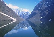
The Sognefjord
Sognefjord
The Sognefjord is the largest fjord in Norway, and the second longest in the world. Located in Sogn og Fjordane county, it stretches inland to the small village of Skjolden...
in Norway stretches 205 kilometres (127.4 mi) inland. It reaches a maximum depth of 1308 metres (4,291.3 ft) below sea level, and, as is characteristic of overdeepening, the greatest depths are found in the inland parts of the fjord. Near its mouth, the bottom rises abruptly to a sill
Sill (geology)
In geology, a sill is a tabular sheet intrusion that has intruded between older layers of sedimentary rock, beds of volcanic lava or tuff, or even along the direction of foliation in metamorphic rock. The term sill is synonymous with concordant intrusive sheet...
about 100 metres (328.1 ft) below sea level. The average width of the main branch of the Sognefjord is about 4.5 kilometres (2.8 mi). Cliffs surrounding the fjord rise almost sheer from the water to heights of 1000 metres (3,280.8 ft) and more. The Skelton Inlet
Skelton Inlet
The Skelton Inlet is an ice-filled inlet at the terminus of the Skelton Glacier, along the western edge of the Ross Ice Shelf in Antarctica. The feature is about 16 km wide at the entry points between Cape Timberlake and Fishtail Point, where it is about 1500 m deep. Its deepest point is...
in Antarctica shows similar overdeepening to 1933 m (6,342 ft), as does the Messier Channel
Messier Channel
Messier Channel is a channel located in Patagonia, Chile. It trends north-south between Wellington Island and other Pacific islands and the continent, and is bounded on the north by the Gulf of Penas. This channel is named after Charles Messier, who was a French astronomer. It is a fjord in the...
in Chile which deepens to 1288 m (4,226 ft).
.jpg)
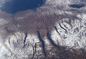
Fjord lakes
Moraine
A moraine is any glacially formed accumulation of unconsolidated glacial debris which can occur in currently glaciated and formerly glaciated regions, such as those areas acted upon by a past glacial maximum. This debris may have been plucked off a valley floor as a glacier advanced or it may have...
s blocking the outlet are called fjords or "fjord lakes" (which follows the Norwegian fjord-naming convention). Fjord lakes are commonly formed in mountainous regions which channel ice flows through narrow valleys.
Although they exist in many countries, the fjord lakes found in British Columbia
British Columbia
British Columbia is the westernmost of Canada's provinces and is known for its natural beauty, as reflected in its Latin motto, Splendor sine occasu . Its name was chosen by Queen Victoria in 1858...
, Canada
Canada
Canada is a North American country consisting of ten provinces and three territories. Located in the northern part of the continent, it extends from the Atlantic Ocean in the east to the Pacific Ocean in the west, and northward into the Arctic Ocean...
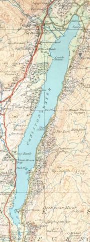
are illustrative of their nature. There the interior plateau is dissected by numerous elongated, glacially overdeepened lakes. One such lake is Okanagan Lake
Okanagan Lake
Okanagan Lake is a large, deep lake in the Okanagan Valley of British Columbia. The lake is 135 km long, between 4 and 5 km wide, and has a surface area of 351 km². The lake's maximum depth is 232 meters near Grant Island...
, which is 3.5 km wide, 120 km long, and excavated by glacial erosion to over 2000 m (6,562 ft) below the surrounding plateau (and 600 m (1,969 ft) below sea level), although much of that depth is filled with glacial sediment so that the current maximum lake depth is 232 m (761 ft). Similar fjord lakes
Fjord
Geologically, a fjord is a long, narrow inlet with steep sides or cliffs, created in a valley carved by glacial activity.-Formation:A fjord is formed when a glacier cuts a U-shaped valley by abrasion of the surrounding bedrock. Glacial melting is accompanied by rebound of Earth's crust as the ice...
in excess of 100 km (62 mi) in length are found elsewhere in British Columbia. Kootenay Lake
Kootenay Lake
Kootenay Lake is a lake located in British Columbia, Canada and is part of theKootenay River. The lake has been raised by the Corra Linn Dam and has a dike system at the southern end, which, along with industry in the 1950s-70s, has changed the ecosystem in and around the water...
located between the Selkirk
Selkirk Mountains
The Selkirk Mountains are a mountain range spanning the northern portion of the Idaho Panhandle, eastern Washington, and southeastern British Columbia. They begin at Mica Peak near Coeur d'Alene, Idaho and extend approximately 320 km north from the border. The range is bounded on its west,...
and Purcell
Purcell Mountains
The Purcell Mountains are a mountain range in southeastern British Columbia, Canada. They are a subrange of the Columbia Mountains, which includes the Selkirk, Monashee, and Cariboo Mountains. They are located on the west side of the Rocky Mountain Trench in the area of the Columbia Valley, and on...
mountain range
Mountain range
A mountain range is a single, large mass consisting of a succession of mountains or narrowly spaced mountain ridges, with or without peaks, closely related in position, direction, formation, and age; a component part of a mountain system or of a mountain chain...
s in the Kootenay
Kootenays
The Kootenay Region comprises the southeastern portion of British Columbia. It takes its name from the Kootenay River, which in turn was named for the Ktunaxa First Nation first encountered by explorer David Thompson.-Boundaries:The Kootenays are more or less defined by the Kootenay Land...
region of British Columbia
British Columbia
British Columbia is the westernmost of Canada's provinces and is known for its natural beauty, as reflected in its Latin motto, Splendor sine occasu . Its name was chosen by Queen Victoria in 1858...
is approximately 100 km (62 mi) in length and 3–5 km in width formerly discharged through the Purcell Trench into Lake Missoula in Montana
Montana
Montana is a state in the Western United States. The western third of Montana contains numerous mountain ranges. Smaller, "island ranges" are found in the central third of the state, for a total of 77 named ranges of the Rocky Mountains. This geographical fact is reflected in the state's name,...
. Similarly tunnel channels in the Flathead Valley beneath Flathead Lake were formed by subglacial drainage from multiple sources such as northwest of the valley (the Rocky Mountain trench), north of the valley (the Whitefish Range), and northeast of the valley (the Middle and North Forks of the Flathead River) and funneled into the valley, exiting south eventually into the Mission Valley and glacial Lake Missoula. The bases of the tunnel channels are cut well below the elevation of Flathead Lake, indicating that erosion occurred in hydrostatically pressurized subglacial tunnel channels beneath the ice in British Columbia.
Tunnel valleys
Tunnel valley
A tunnel valley is a large, long, U-shaped valley originally cut under the glacial ice near the margin of continental ice sheets such as that now covering Antarctica and formerly covering portions of all continents during past glacial ages....
is a large, long, U-shaped valley originally cut under the glacial ice near the margin of continental ice sheets such as that now covering Antarctica and formerly covering portions of all continents during past glacial ages. They range in size (up to 100 km in length and up to 4 km in width). Tunnel valleys exhibit classical overdeepening with maximum depths that may vary between 50 and 400 m; they vary in depth along the long axis. Their cross-sections exhibit steep sided flanks (similar to fjord walls) and flat bottoms typical of subglacial glacial erosion. Tunnel valleys were formed by subglacial erosion by water and served as subglacial drainage pathways carrying large volumes of melt water. They presently appear as dry valleys, lakes, seabed depressions, and as areas filled with sediment. If they are filled with sediment their lower layers are filled primarily with glacial, glaciofluvial or glaciolacustrine sediment, supplemented by upper layers of temperate infill. They can be found in areas formerly covered by glacial ice sheets including Africa, Asia, North America, Europe, Australia and offshore in the North Sea, the Atlantic and in waters near Antarctica.
Tunnel valleys appear in the technical literature under several terms, including tunnel channels, subglacial valleys, and linear incisions.
Cirques
Cirque
Cirque may refer to:* Cirque, a geological formation* Makhtesh, an erosional landform found in the Negev desert of Israel and Sinai of Egypt*Cirque , an album by Biosphere* Cirque Corporation, a company that makes touchpads...
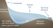
s near glacier heads. The concave amphitheatre shape is open on the downhill side corresponding to the flatter area of the stage, while the cupped seating section is generally steep cliff-like slopes down which ice and glaciated debris combine and converge from the three or more higher sides. The floor of the cirque ends up bowl shaped as it is the complex convergence zone of combining ice flows from multiple directions and their accompanying rock burdens, hence experiences somewhat greater erosion forces, and is most often scooped out somewhat below the level of cirque's low-side outlet (stage) and its down slope (backstage) valley. A tarn
Tarn
Tarn is a department of 5,758 km2 in the Midi-Pyrénées region in the southwest of France, named after the Tarn River. It was formed in 1790 of the three dioceses of Albi, Castres and Lavaur, belonging to the province of Languedoc. In 1906, the population was 330,533...
will form in the overdeepened region once the glacier has melted.
Geomorphology
Glacial erosion proceeds by abrasion as ice and entrained debris moves across the underlying bedrock, by water induced erosion and transport of sediment, and by freeze-thaw cycles which weather the bedrock. All processes are most effective at the bottom of glacial ice - hence the glacier erodes at the bottom. The presence of ice in the gap reduces the rate at which the side walls weather, yielding steep side walls. When the course of glacial ice flow is constrained by surrounding topography, the narrowest regions of flow will abrade most rapidly and cut most deeply, even to depths over 1000 meters below sea level. The resulting profile, when observed through the ice with radar or when evident after the ice had melted, is referred to as overdeepened. Although research remains in fully understanding the processes involved, significant progress has been evident in the late 20th and early 21st centuries. This section details major elements in the emerging understanding of the processes which produce overdeepening.Glaciologists performed a detailed radar survey of Antarctica's Gamburtsev Mountains during the International Polar Year
International Polar Year
The International Polar Year is a collaborative, international effort researching the polar regions. Karl Weyprecht, an Austro-Hungarian naval officer, motivated the endeavor, but died before it first occurred in 1882-1883. Fifty years later a second IPY occurred...
, allowing both the overlying glacial ice thickness and the elevation of the bedrock below to be found. The survey shows overdeepening in the valley floors of up to 432 metres (1,417.3 ft) while the valleys exhibit steep side troughs. The figure to the left shows the three major regions of overdeepening, of 3 kilometres (2 mi), 6 kilometres (4 mi), and 16 kilometres (10 mi) in length. Portions of this profile will be used to illustrate the formation of overdeepened valleys.
Headwall zone
The upglacier side of an overdeepening is referred to as the headwall, while the downglacier side is referred to as an adverse slope. Water flowing down the headwall gains energy, which melts the surrounding ice, creating channels. As the water passes through the bottom, it continues to drop in temperature; since it is highly pressurized at this point, the melting temperature is suppressed and the water becomes supercooled as it melts surrounding ice. The flowing water transports sediment and locally erodes the bedrock.Surface water drains via moulins to a subglacial system of conduits which allow flow into cavities in the ice. As the flow increases the head loss in the conduits increases, resulting in increasing water levels and correspondingly higher hydraulic pressure at the headwall of the glacier. As the conduits pressurize, they pressurize the cavities and the porous basal till. The pressurization backs water up within the glacier and the increased pressure at the bed, reduces the pressure the ice exerts against the bed (referred to as the effective pressure at the bed). Since friction with the bed is proportional to the effective pressure at the bed, this pressurization promotes basal motion of the glacier.
Erosion is greatest along the headwall. This is attributed to the seasonal entry of water in those areas via moulins, resulting in varying but periodically high pressures, high flow rates, and large temperature variations. This variation is thought to contribute to quarrying of blocks from the headwall combined with the erosive powers of rapidly moving debris streams entrained in flowing water.
Channeled zone
Glacier surface melt waters tend to migrate to the base of the ice sheet. Once there the water lubricates the interface between the ice and the bedrock. The hydraulic pressure of the water becomes significant - it is driven by surface slope of the overlying ice and by the bed topography. The hydraulic pressure offsets part of the weight of the glacier (the lower density ice tends to be displaced by water). Both effects enhance basal ice motion. Ice motion data reveal substantial increases in ice velocity during periods when meltwater is present (i.e., the summer( when compared to the winter background values. The glacier does not move uniformly, but rather shows changing patterns of motion as the season progresses, which result from the seasonal evolution of the subglacial drainage system. The largest glacial movements were observed during periods of transition, as increasing water was released into the glacier.Variable water inflow increase the ice flow rate. Observations show that subglacial water drains either through channels at low pressure or through interconnected cavities at high pressure. Above a critical rate of water flow, channelization and glacier deceleration results. Higher rates of steady water flow actually suppress glacial movement. Episodic increases in water input such as those produced by strong diurnal melt cycles result in temporary water pressure excursions. Such spikes produce ice acceleration. Similarly, rain and surface lake drainage events will cause movement.
Analytic glacial erosion models suggest that ice flows passing through constrained spaces such as mountain passes produced enhanced erosion beneath thicker, faster ice flows, which deepens the channel below areas both upstream and downstream. The underlying physical phenomena is that erosion increases with the rate of ice discharge. Although this simplifies complex relationships among time-varying climates, ice sheet behaviors and bed characteristics, it is based on the general recognition that enhanced ice discharges typically increase the erosion rate. This is because the basal sliding rate and the erosion rate are interrelated and driven by the same variables: the ice thickness, the underlying bed slope, the overlying glacial slope and the basal temperature. As a result, the modeled fjords are deepest through the narrowest channels (i.e., regions with the highest surrounding highest topography). This corresponds with actual physical observations of fjords.
Adverse slope zone
As it continues to flow and begins to rise up the adverse slope beneath temperate (or "warm-based") glaciers, the pressure decreases and frazil iceFrazil ice
Frazil ice is a collection of loose, randomly oriented needle-shaped ice crystals in water. It resembles slush and has the appearance of being slightly oily when seen on the surface of water...
accretes in the basal ice. The sediment load carried by the water will be entrained in the accreted ice. At the point in the glacier where the ice is accreting on the adverse slope near the glacier terminus, ablation
Ablation
Ablation is removal of material from the surface of an object by vaporization, chipping, or other erosive processes. This occurs in spaceflight during ascent and atmospheric reentry, glaciology, medicine, and passive fire protection.-Spaceflight:...
of the upper surface ice exceeds (for recently observed glaciers) the rate of accretion at the bottom. The net effect is that for a glacier which retains its overall shape, glacier mass will be transferred by water flow to accrete new ice, by sediment transport into meters thick layers observed in the accretion zone, and by movement of the total ice mass to restore the ice lost to ablation.
The sediment-transport capacity and sediment load in subglacial stream glaciers in which the water is not supercooled and for a glacier far into the supercooling regime vary significantly. When a moraine
Moraine
A moraine is any glacially formed accumulation of unconsolidated glacial debris which can occur in currently glaciated and formerly glaciated regions, such as those areas acted upon by a past glacial maximum. This debris may have been plucked off a valley floor as a glacier advanced or it may have...
or moraine shoal (bedrock) has developed, the overdeepening terminates in a growing sediment-floored feature. When there is a significant increase in the elevation on the adverse slope, ice grows from supercooling of streams flowing up the overly steep face of the moraine shoal causes transport capacity to drop below load
delivered, producing deposition to fill the adverse face of the overdeepening back towards the supercooling threshold. When the flow is able to remove all the sediment delivered but not able to erode bedrock as
rapidly as the upstream glacier erodes bedrock in the overdeepened area, then the ice forms on
bedrock, and subglacial erosion lowers the glacier bed in the overdeepened region while leaving a bedrock sill.
Subglacial ice lens formation
Subglacial erosion is accelerated by subglacial ice lensIce lens
An Ice Lens or ice lenses are formed when moisture, diffused within soil or rock, accumulates in a localized zone. The ice initially accumulates within small collocated pores or pre-existing crack, and, as long as the conditions remain favorable, continues to collect in the ice layer or ice lens,...
formation, which contributes to the overdeepening process.
Bands of sediment or glacial till have been observed below Antarctic ice sheets; these are believed to result from ice lenses forming in the debris and in the bedrock. In the faster flowing glacial regions, the ice sheet is sliding over water saturated sediments (glacial till) or actually being floated upon a layer of water. The till and water served to reduce friction between the base of the ice sheet and the bedrock. These subglacial waters come from surface water which seasonally drains from melting at the surface, as well as from ice-sheet base melting.
Ice lens growth within the bedrock below the glacier is projected during the summer months when there is ample water at the base of the glacier. Ice lenses will form within the bedrock, accumulating until the rock is sufficiently weakened that it shears or spalls off. Layers of rock along the interface between glaciers and the bedrock are freed, producing much of the sediments in these basal regions of glaciers. Since the rate of glacier movement is dependent upon the characteristics of this basal ice, research is ongoing to better quantify the phenomena.
Norwegian fjord lakes
Norwegian fjord lakes provide an excellent illustration of overdeepening; all of the lake bottoms in the following list of the nine deepest fjord lakes in Norway lie below sea level, even though the lakes are freshwater lakes.| No. | Name | Depth (m) |
Surface elevation above sea level (m) | Depth below sea level (m) |
|---|---|---|---|---|
| 1 | Hornindalsvatnet Hornindalsvatnet Hornindalsvatnet is Norway's and Europe's deepest lake, officially measured to a depth of . Its surface is above sea level, which means that its bottom is below sea level. The village of Grodås lies at the eastern end of the lake in Hornindal and the village of Mogrenda is located on the... |
514 metres (1,686.4 ft) | 53 metres (173.9 ft) | -460 m |
| 2 | Salsvatn Salsvatn Salsvatn or Salsvatnet is a lake in the municipalities of Fosnes and Nærøy in Nord-Trøndelag county, Norway. With its deepest depth of , it is Norway’s and Europe’s second deepest lake, after Hornindalsvatnet. Alternate sources give the depth as either or at the deepest point... |
482 metres (1,581.4 ft) | 16 metres (52.5 ft) | -466 m |
| 3 | Tinnsjå Tinnsjå Tinnsjå is one of the largest lakes in Norway. It is located between the municipalities of Tinn and Notodden in Telemark county. At its source in the west, the Måna river flows out of Møsvatn and past Rjukan into Tinnsjå... |
460 metres (1,509.2 ft) | 190 metres (623.4 ft) | -270 m |
| 4 | Mjøsa Mjøsa Mjøsa is Norway's largest lake, as well as one of the deepest lakes in Norway and in Europe as a whole, after Hornindalsvatnet. It is located in the southern part of Norway, about 100 km north of Oslo... |
444 metres (1,456.7 ft) | 121 metres (397 ft) | -323 m |
| 5 | Fyresvatn Fyresvatn Fyresvatn, , is the fifth deepest lake in Norway with a depth of 377 m.It is located in Fyresdal municipality, part of Telemark county.... |
377 metres (1,236.9 ft) | 279 metres (915.4 ft) | -98 m |
| 6 | Suldalsvatnet | 376 metres (1,233.6 ft) | 68 metres (223.1 ft) | -308 m |
| 7 | Bandak Bandak Bandak is a lake in the municipality of Kviteseid and Tokke in Telemark county, Norway. The lake, which is part of the Telemark Canal route, belongs to the Skien watershed... |
325 metres (1,066.3 ft) | 72 metres (236.2 ft) | -253 m |
| 8 | Lundevatn Lundevatn Lundevatn is a lake on the borders between the municipalities of Lund in Rogaland county and Flekkefjord in Vest-Agder county, Norway. It is the eighth deepest lake in Norway and extends 365 m below sea level. This overdeepening, as well as its long and narrow shape, are characteristics of... |
314 metres (1,030.2 ft) | 49 metres (160.8 ft) | -265 m |
| 9 | Storsjøen Storsjøen (Rendalen) Storsjøen is the ninth deepest lake in Norway at 309 m in depth. It lies in Rendalen and Åmot municipalities which are in Hedmark county, Norway. The lake is 35 km long, but only 1.7 km wide at its broadest point. The lake lies 251 meters above sea level, has an area of... (in Rendalen) |
309 metres (1,013.8 ft) | 259 metres (849.7 ft) | -50 m |
Alternate use of the term "overdeepening"
Geologists apply the term overdeepening to one phenomenon other than glacial overdeepening - the dramatic river valley downcutting which can occur when the sea into which it discharges dries out. In what is referred to as the Messinian salinity crisisMessinian salinity crisis
The Messinian Salinity Crisis, also referred to as the Messinian Event, and in its latest stage as the Lago Mare event, was a geological event during which the Mediterranean Sea went into a cycle of partly or nearly complete desiccation throughout the latter part of the Messinian age of the Miocene...
the Mediterranean Sea
Mediterranean Sea
The Mediterranean Sea is a sea connected to the Atlantic Ocean surrounded by the Mediterranean region and almost completely enclosed by land: on the north by Anatolia and Europe, on the south by North Africa, and on the east by the Levant...
basin was geologically separate from the Atlantic ocean
Atlantic Ocean
The Atlantic Ocean is the second-largest of the world's oceanic divisions. With a total area of about , it covers approximately 20% of the Earth's surface and about 26% of its water surface area...
. Evaporation dropped the sea level by over 1000 meters at the mouth of the Rhone River
Rhône River
The Rhone is one of the major rivers of Europe, rising in Switzerland and running from there through southeastern France. At Arles, near its mouth on the Mediterranean Sea, the river divides into two branches, known as the Great Rhone and the Little Rhone...
and 2,500 meters at the mouth of the Nile River, resulting in overdeepening of these valleys. The Nile
Nile
The Nile is a major north-flowing river in North Africa, generally regarded as the longest river in the world. It is long. It runs through the ten countries of Sudan, South Sudan, Burundi, Rwanda, Democratic Republic of the Congo, Tanzania, Kenya, Ethiopia, Uganda and Egypt.The Nile has two major...
cut its bed down to several hundred feet below sea level far upstream at Aswan
Aswan
Aswan , formerly spelled Assuan, is a city in the south of Egypt, the capital of the Aswan Governorate.It stands on the east bank of the Nile at the first cataract and is a busy market and tourist centre...
, and 8,000 feet (2,500 m
Metre
The metre , symbol m, is the base unit of length in the International System of Units . Originally intended to be one ten-millionth of the distance from the Earth's equator to the North Pole , its definition has been periodically refined to reflect growing knowledge of metrology...
) below sea level just north of Cairo
Cairo
Cairo , is the capital of Egypt and the largest city in the Arab world and Africa, and the 16th largest metropolitan area in the world. Nicknamed "The City of a Thousand Minarets" for its preponderance of Islamic architecture, Cairo has long been a centre of the region's political and cultural life...
.