
Kootenay Lake
Encyclopedia
Kootenay Lake is a lake
located in British Columbia
, Canada
and is part of the
Kootenay River
. The lake has been raised by the Corra Linn Dam
and has a dike system at the southern end, which, along with industry in the 1950s-70s, has changed the ecosystem in and around the water. Kootenay Lake has a year round toll-free ferry that crosses between Kootenay Bay
and Balfour
, and is a popular summer tourist destination.
-like lake located between the Selkirk
and Purcell
mountain range
s in the Kootenay
region of British Columbia. It is one of the largest lakes in British Columbia, at 104 km in length and 3-5 km in width. It is, in part, a widening of the Kootenay River
, which in turn drains into the Columbia River
system at Castlegar, British Columbia
.
Although oriented primarily in a north-south configuration, a western arm positioned roughly halfway up the length of the lake stretches 35 km to the City of Nelson
. The lake is 532m above sea level, with the adjacent mountains rising up to a maximum of approximately 2700m. The average residence for water in the lake is 1.5 years, although the west arm has a much faster rate of water replacement; about 3-4 days.
Kootenay Lake was formed through river erosion
and, later, glaciation. The erosion began during the late Cretaceous
until ice filled the resulting valley in the Pleistocene
. When the valley was filled with ice, glaciers from the mountains (the Selkirks and Purcells) fed the valley's ice mass. The glacier that occupied what is now the west arm of Kootenay Lake flowed into the Kootenay ice mass. As the ice melted from this glacier, drainage flowed over an area near what is now Nelson, causing the west arm of the lake to drain toward the west. A large moraine
formed near what is now the large bend in the Kootenay River near Libby, Montana
. As ice melted, a lake formed behind the moraine and drained southward over top of it. The southerly drainage over the moraine eventually stopped and the Kootenay River began to follow its present course.
and Ktunaxa peoples. These native populations used the lake and associated river systems as part of their seasonal migration and trading routes.
In 1958 the Kootenay Lake Crossing
, an electrical power line
, was built, running across the north arm of Kootenay Lake. It was destroyed in 1962 by protestors and rebuilt later that year.
The lake originally tidally
and seasonally flood
ed an approximately 80 km long marsh
lying to the lake's south within the Creston Valley
. However, this has now been diked and converted to commercial agriculture
. A smaller wetland area has been protected in this area.
In 1931, Corra Linn Dam
was built at the mouth of Kootenay Lake, where it once again became a river. Just down river was Bonnington Falls, today the site of several hydroelectric dams. In 2003 the lake discharged 16900000 acre.ft of water. High water for that year was a normal 533 metres, the record is 537 metres in 1961. In 1967 as part of the Columbia River Treaty
the Duncan Dam
was constructed above Kootenay Lake on the Duncan River
, creating a 7,145 hectare reservoir for flood control. Also part of the treaty Libby Dam
in Montana, was completed in 1975.
.
There was a large decrease in the numbers of Kokanee in the west arm of the lake in the late 1970s. The salmon fishery was closed in 1980 and remains closed as of 2011. The reason for the decline is not known; possibilities include reduced numbers of Mysis relicta
(which had been introduced as a food source for the Kokanee in 1949) into the west arm due to the increased control of water levels, the disruption of rearing habitat due to recurring drawdown
of the lake, reduced productivity of benthos
due to the reduction of the amount of nutrients into the lake (after the close of the fertilizer plant), overfishing in the 1960s to 1970s or competition between the Mysis relicta and immature fish. In 1990 the lake's southern Kokanee stocks neared extinction, and an experimental fertilizing program was started, with some success.
. The remaining are scattered among a number of small towns and villages:
opened in 1953. Large quantities of phosphorus
entered the Kootenay River; the cause of cyanobacterial blooms from the 1950s until the early 1970s. Attempts to limit pollution, the closure of the plant (in 1973), and construction of the Libby Dam
on the Kootenai River in Montana
combined to reduce phosphorus levels in the lake from the recorded highs.
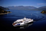
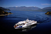 The lake is crossed by the Kootenay Lake Ferry
, a toll-free vehicular ferry operating between Balfour and Kootenay Bay. The ferry operates two boats in the summer and one during the winter.
Lake
A lake is a body of relatively still fresh or salt water of considerable size, localized in a basin, that is surrounded by land. Lakes are inland and not part of the ocean and therefore are distinct from lagoons, and are larger and deeper than ponds. Lakes can be contrasted with rivers or streams,...
located in British Columbia
British Columbia
British Columbia is the westernmost of Canada's provinces and is known for its natural beauty, as reflected in its Latin motto, Splendor sine occasu . Its name was chosen by Queen Victoria in 1858...
, Canada
Canada
Canada is a North American country consisting of ten provinces and three territories. Located in the northern part of the continent, it extends from the Atlantic Ocean in the east to the Pacific Ocean in the west, and northward into the Arctic Ocean...
and is part of the
Kootenay River
Kootenay River
The Kootenay is a major river in southeastern British Columbia, Canada and the northern part of the U.S. states of Montana and Idaho. It is one of the uppermost major tributaries of the Columbia River, which is the largest North American river that empties into the Pacific Ocean...
. The lake has been raised by the Corra Linn Dam
Corra Linn Dam
Corra Linn Dam is a concrete hydroelectric dam on the Kootenay River in the Canadian province of British Columbia. It is located where the West Arm Kootenay Lake flows into the Kootenay River. The dam's powerplant has a generating capacity of 49 MW. The dam was formerly owned by West Kootenay Power...
and has a dike system at the southern end, which, along with industry in the 1950s-70s, has changed the ecosystem in and around the water. Kootenay Lake has a year round toll-free ferry that crosses between Kootenay Bay
Kootenay Bay, British Columbia
Kootenay Bay is an unincorporated community, ferry landing and former steamboat landing on the east side of Kootenay Lake, located on the bay of the same name. The ferry, operated by BC Ferries, crosses the lake to Balfour, and forms a link in BC Highway 6, which leads east from Balfour to nearby...
and Balfour
Balfour, British Columbia
Balfour, also known as Balfour Bay, is an unincorporated community in British Columbia, located about northeast of the city of Nelson and located at the juncture of Kootenay Lake with its West Arm....
, and is a popular summer tourist destination.
Geography
Kootenay Lake is a long, narrow and deep fjordFjord
Geologically, a fjord is a long, narrow inlet with steep sides or cliffs, created in a valley carved by glacial activity.-Formation:A fjord is formed when a glacier cuts a U-shaped valley by abrasion of the surrounding bedrock. Glacial melting is accompanied by rebound of Earth's crust as the ice...
-like lake located between the Selkirk
Selkirk Mountains
The Selkirk Mountains are a mountain range spanning the northern portion of the Idaho Panhandle, eastern Washington, and southeastern British Columbia. They begin at Mica Peak near Coeur d'Alene, Idaho and extend approximately 320 km north from the border. The range is bounded on its west,...
and Purcell
Purcell Mountains
The Purcell Mountains are a mountain range in southeastern British Columbia, Canada. They are a subrange of the Columbia Mountains, which includes the Selkirk, Monashee, and Cariboo Mountains. They are located on the west side of the Rocky Mountain Trench in the area of the Columbia Valley, and on...
mountain range
Mountain range
A mountain range is a single, large mass consisting of a succession of mountains or narrowly spaced mountain ridges, with or without peaks, closely related in position, direction, formation, and age; a component part of a mountain system or of a mountain chain...
s in the Kootenay
Kootenays
The Kootenay Region comprises the southeastern portion of British Columbia. It takes its name from the Kootenay River, which in turn was named for the Ktunaxa First Nation first encountered by explorer David Thompson.-Boundaries:The Kootenays are more or less defined by the Kootenay Land...
region of British Columbia. It is one of the largest lakes in British Columbia, at 104 km in length and 3-5 km in width. It is, in part, a widening of the Kootenay River
Kootenay River
The Kootenay is a major river in southeastern British Columbia, Canada and the northern part of the U.S. states of Montana and Idaho. It is one of the uppermost major tributaries of the Columbia River, which is the largest North American river that empties into the Pacific Ocean...
, which in turn drains into the Columbia River
Columbia River
The Columbia River is the largest river in the Pacific Northwest region of North America. The river rises in the Rocky Mountains of British Columbia, Canada, flows northwest and then south into the U.S. state of Washington, then turns west to form most of the border between Washington and the state...
system at Castlegar, British Columbia
Castlegar, British Columbia
Castlegar is the second largest city in the West Kootenay region of British Columbia, Canada. It is located within the Selkirk Mountains at the confluence of the Kootenay and Columbia Rivers. It is a regional trade and transportation centre, with a local economy fueled by forestry, mining and tourism...
.
Although oriented primarily in a north-south configuration, a western arm positioned roughly halfway up the length of the lake stretches 35 km to the City of Nelson
Nelson, British Columbia
Nelson is a city located in the Selkirk Mountains on the extreme West Arm of Kootenay Lake in the Southern Interior of British Columbia, Canada. Known as "The Queen City", and acknowledged for its impressive collection of restored heritage buildings from its glory days in a regional silver rush,...
. The lake is 532m above sea level, with the adjacent mountains rising up to a maximum of approximately 2700m. The average residence for water in the lake is 1.5 years, although the west arm has a much faster rate of water replacement; about 3-4 days.
Kootenay Lake was formed through river erosion
Erosion
Erosion is when materials are removed from the surface and changed into something else. It only works by hydraulic actions and transport of solids in the natural environment, and leads to the deposition of these materials elsewhere...
and, later, glaciation. The erosion began during the late Cretaceous
Cretaceous
The Cretaceous , derived from the Latin "creta" , usually abbreviated K for its German translation Kreide , is a geologic period and system from circa to million years ago. In the geologic timescale, the Cretaceous follows the Jurassic period and is followed by the Paleogene period of the...
until ice filled the resulting valley in the Pleistocene
Pleistocene
The Pleistocene is the epoch from 2,588,000 to 11,700 years BP that spans the world's recent period of repeated glaciations. The name pleistocene is derived from the Greek and ....
. When the valley was filled with ice, glaciers from the mountains (the Selkirks and Purcells) fed the valley's ice mass. The glacier that occupied what is now the west arm of Kootenay Lake flowed into the Kootenay ice mass. As the ice melted from this glacier, drainage flowed over an area near what is now Nelson, causing the west arm of the lake to drain toward the west. A large moraine
Moraine
A moraine is any glacially formed accumulation of unconsolidated glacial debris which can occur in currently glaciated and formerly glaciated regions, such as those areas acted upon by a past glacial maximum. This debris may have been plucked off a valley floor as a glacier advanced or it may have...
formed near what is now the large bend in the Kootenay River near Libby, Montana
Libby, Montana
Libby is a city in and the county seat of Lincoln County, Montana, United States. The population was 2,626 at the 2000 census.-Geography:Libby is located at , along U.S. Route 2....
. As ice melted, a lake formed behind the moraine and drained southward over top of it. The southerly drainage over the moraine eventually stopped and the Kootenay River began to follow its present course.
History
Kootenay Lake is part of the traditional territory of the SinixtSinixt
The Sinixt are a First Nations People...
and Ktunaxa peoples. These native populations used the lake and associated river systems as part of their seasonal migration and trading routes.
In 1958 the Kootenay Lake Crossing
Kootenay Lake Crossing
Kootenay Lake Crossing was a powerline crossing of Kootenay Lake, British Columbia, Canada. The idea was to move electricity from the Hydro dam on the Kootenay River...
, an electrical power line
Electric power transmission
Electric-power transmission is the bulk transfer of electrical energy, from generating power plants to Electrical substations located near demand centers...
, was built, running across the north arm of Kootenay Lake. It was destroyed in 1962 by protestors and rebuilt later that year.
The lake originally tidally
Tide
Tides are the rise and fall of sea levels caused by the combined effects of the gravitational forces exerted by the moon and the sun and the rotation of the Earth....
and seasonally flood
Flood
A flood is an overflow of an expanse of water that submerges land. The EU Floods directive defines a flood as a temporary covering by water of land not normally covered by water...
ed an approximately 80 km long marsh
Marsh
In geography, a marsh, or morass, is a type of wetland that is subject to frequent or continuous flood. Typically the water is shallow and features grasses, rushes, reeds, typhas, sedges, other herbaceous plants, and moss....
lying to the lake's south within the Creston Valley
Creston Valley
The Creston Valley is a Canadian river delta wetland and Wildlife Management Area near Creston in south-central British Columbia, on the floodplain of the Kootenay River at the south end of Kootenay Lake. Predominantly marshland, it was classified as a wetland of international importance on...
. However, this has now been diked and converted to commercial agriculture
Agriculture
Agriculture is the cultivation of animals, plants, fungi and other life forms for food, fiber, and other products used to sustain life. Agriculture was the key implement in the rise of sedentary human civilization, whereby farming of domesticated species created food surpluses that nurtured the...
. A smaller wetland area has been protected in this area.
In 1931, Corra Linn Dam
Corra Linn Dam
Corra Linn Dam is a concrete hydroelectric dam on the Kootenay River in the Canadian province of British Columbia. It is located where the West Arm Kootenay Lake flows into the Kootenay River. The dam's powerplant has a generating capacity of 49 MW. The dam was formerly owned by West Kootenay Power...
was built at the mouth of Kootenay Lake, where it once again became a river. Just down river was Bonnington Falls, today the site of several hydroelectric dams. In 2003 the lake discharged 16900000 acre.ft of water. High water for that year was a normal 533 metres, the record is 537 metres in 1961. In 1967 as part of the Columbia River Treaty
Columbia River Treaty
The Columbia River Treaty is an agreement between Canada and the United States of America on the development and operation of dams in the upper Columbia River basin for power and flood control benefits in both countries. For more information about the Columbia River Treaty, visit Columbia Basin...
the Duncan Dam
Duncan Dam
Duncan Dam is a dam spanning the Duncan River in the Canadian province of British Columbia.Duncan Dam was the first dam built to satisfy the Columbia River Treaty, initiated after the 1948 Vanport Oregon flood. Construction began in 1965 and was completed in 1967. It is an earthfill dam with no...
was constructed above Kootenay Lake on the Duncan River
Duncan River
The Duncan River is a long river in the Canadian province of British Columbia. Its drainage basin is in area. It is part of the Columbia River basin, being tributary via Kootenay Lake to the Kootenay River, which is a tributary of the Columbia River...
, creating a 7,145 hectare reservoir for flood control. Also part of the treaty Libby Dam
Libby Dam
Libby Dam is a dam on the Kootenai River in the U.S. state of Montana.Dedicated on August 24, 1975, Libby Dam spans the Kootenai River upstream from the town of Libby, Montana. Libby Dam is tall and long. Lake Koocanusa is the name of the reservoir behind the dam; it extends upriver from...
in Montana, was completed in 1975.
Fauna
There are seven species of fish in Kootenay Lake: Rainbow Trout (Gerrard), Dolly Varden Trout, Burbot, Mountain Whitefish, White Sturgeon, Brook Trout, Largemouth Bass, Yellow Perch and Kokanee SalmonSockeye salmon
Sockeye salmon , also called red salmon or blueback salmon in the USA, is an anadromous species of salmon found in the Northern Pacific Ocean and rivers discharging into it...
.
There was a large decrease in the numbers of Kokanee in the west arm of the lake in the late 1970s. The salmon fishery was closed in 1980 and remains closed as of 2011. The reason for the decline is not known; possibilities include reduced numbers of Mysis relicta
Mysis relicta
Mysis relicta is a shrimp-like crustacean in the Mysida order, native to lakes of Northern Europe and to the brackish Baltic Sea.-Appearance:Mysis is a small, transparent shrimp-like crustacean, of less than 2.5 cm length...
(which had been introduced as a food source for the Kokanee in 1949) into the west arm due to the increased control of water levels, the disruption of rearing habitat due to recurring drawdown
Drawdown (hydrology)
In water-related science and engineering there are two similar but distinct definitions in use for drawdown.*In subsurface hydrogeology, drawdown is the change in hydraulic head observed at a well in an aquifer, typically due to pumping a well as part of an aquifer test or well test.*In surface...
of the lake, reduced productivity of benthos
Benthos
Benthos is the community of organisms which live on, in, or near the seabed, also known as the benthic zone. This community lives in or near marine sedimentary environments, from tidal pools along the foreshore, out to the continental shelf, and then down to the abyssal depths.Many organisms...
due to the reduction of the amount of nutrients into the lake (after the close of the fertilizer plant), overfishing in the 1960s to 1970s or competition between the Mysis relicta and immature fish. In 1990 the lake's southern Kokanee stocks neared extinction, and an experimental fertilizing program was started, with some success.
Settlements
Approximately 19,700 people live within 2.5km of the Kootenay Lake shore; about 14,300 of those live in the City of NelsonNelson, British Columbia
Nelson is a city located in the Selkirk Mountains on the extreme West Arm of Kootenay Lake in the Southern Interior of British Columbia, Canada. Known as "The Queen City", and acknowledged for its impressive collection of restored heritage buildings from its glory days in a regional silver rush,...
. The remaining are scattered among a number of small towns and villages:
- Boswell, British ColumbiaBoswell, British ColumbiaBoswell is a rural locality on the east shore of Kootenay Lake approximately 35km due east of the city of Nelson, British Columbia, Canada.- See Also :Crawford Bay, British ColumbiaKootenay Lake FerryGlass House...
- Crawford Bay, British ColumbiaCrawford Bay, British ColumbiaCrawford Bay is a community of approximately 350 people, situated in the Purcell mountain range on the eastern shore of Kootenay Lake in the Southern Interior of British Columbia, Canada...
- Ainsworth, British ColumbiaAinsworth, British ColumbiaAinsworth or Ainsworth Hot Springs is a historic village on Kootenay Lake in British Columbia, Canada and has a population of 50.Founded on May 31, 1883, it is the oldest surviving community on Kootenay Lake....
- Kaslo, British ColumbiaKaslo, British ColumbiaKaslo is a village in the West Kootenay region of British Columbia, Canada, located on the west shore of Kootenay Lake. Known for its great natural beauty, it is a member municipality of the Central Kootenay Regional District...
- Riondel, British ColumbiaRiondel, British ColumbiaRiondel is a village of approximately 400 people. It is situated on the eastern shore of Kootenay Lake, located 90-minutes from Nelson, British Columbia, using the world's longest free ferry ride.- History :...
- Balfour, British ColumbiaBalfour, British ColumbiaBalfour, also known as Balfour Bay, is an unincorporated community in British Columbia, located about northeast of the city of Nelson and located at the juncture of Kootenay Lake with its West Arm....
- Grey Creek, British Columbia
- Kootenay Bay, British ColumbiaKootenay Bay, British ColumbiaKootenay Bay is an unincorporated community, ferry landing and former steamboat landing on the east side of Kootenay Lake, located on the bay of the same name. The ferry, operated by BC Ferries, crosses the lake to Balfour, and forms a link in BC Highway 6, which leads east from Balfour to nearby...
- Harrop, British Columbia
- Proctor, British Columbia
- Sirdar, British Columbia
Pollution
Water quality in the lake was negatively affected when the Cominco phosphate fertilizer plant on the Kootenay River at KimberleyKimberley, British Columbia
Kimberley is a small city in southeast British Columbia, Canada along Highway 95A between the Purcell and Rocky Mountains. Kimberley was named in 1896 after the Kimberley mine in South Africa. From 1917 to 2001, it was the home to the world's largest lead-zinc mine, the Sullivan Mine...
opened in 1953. Large quantities of phosphorus
Phosphorus
Phosphorus is the chemical element that has the symbol P and atomic number 15. A multivalent nonmetal of the nitrogen group, phosphorus as a mineral is almost always present in its maximally oxidized state, as inorganic phosphate rocks...
entered the Kootenay River; the cause of cyanobacterial blooms from the 1950s until the early 1970s. Attempts to limit pollution, the closure of the plant (in 1973), and construction of the Libby Dam
Libby Dam
Libby Dam is a dam on the Kootenai River in the U.S. state of Montana.Dedicated on August 24, 1975, Libby Dam spans the Kootenai River upstream from the town of Libby, Montana. Libby Dam is tall and long. Lake Koocanusa is the name of the reservoir behind the dam; it extends upriver from...
on the Kootenai River in Montana
Montana
Montana is a state in the Western United States. The western third of Montana contains numerous mountain ranges. Smaller, "island ranges" are found in the central third of the state, for a total of 77 named ranges of the Rocky Mountains. This geographical fact is reflected in the state's name,...
combined to reduce phosphorus levels in the lake from the recorded highs.
Ferry
Kootenay Lake Ferry
The Kootenay Lake Ferry is a ferry across the Kootenay Lake in British Columbia, Canada. It operates between Balfour, on the west side of the lake, and Kootenay Bay, on the east side. Two ferry vessels are used, the MV Osprey 2000 and the MV Balfour.The ferry operates under contract to the British...
, a toll-free vehicular ferry operating between Balfour and Kootenay Bay. The ferry operates two boats in the summer and one during the winter.