
Orinoco
Encyclopedia
The Orinoco is one of the longest rivers
in South America at 2140 km (1,329.7 mi). Its drainage basin
, sometimes called the Orinoquia, covers 880000 square kilometre, with 76.3% of it in Venezuela
and the remainder in Colombia
. The Orinoco and its tributaries are the major transportation system for eastern and interior Venezuela and the llanos
of Colombia.
 Although the mouth of the Orinoco in the Atlantic Ocean
was documented by Columbus
on 1 August 1498, during his third voyage, its source at the Cerro Delgado-Chalbaud, in the Parima range, was first explored in 1951, 453 years later. The source, on the Venezuelan-Brazil
ian border, at 1047 m (3,435 ft) of elevation (02°19′05"N 63°21′42"W ), was explored in 1951 by a joint Venezuelan-French team.
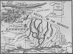
The Orinoco delta, and tributaries in the eastern llanos such as the Apure
and Meta
, were explored in the 16th century by German expeditions under Ambrosius Ehinger
and his successors. In 1531 Diego de Ordaz
, starting at the principal outlet in the delta, the Boca de Navios, sailed up the river to the Meta, and Antonio de Berrio sailed down the Casanare, to the Meta, and then down the Orinoco and back to Coro
.
Alexander von Humboldt
explored the basin in 1800, reporting on the pink river dolphins
, and publishing extensively on the flora and fauna.
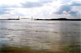
 At its mouth, the Orinoco forms a wide delta that branches off into hundreds of rivers and waterways that flow through 41000 square kilometre of swampy forests. In the rainy season, the Orinoco can swell to a breadth of 22 kilometres (14 mi) and a depth of 100 metre.
Most of the important Venezuelan rivers are tributaries of the Orinoco, the largest being the Caroní, which joins it at Puerto Ordaz
, close to the Llovizna Falls. A peculiarity of the Orinoco river system is the Casiquiare canal
, which starts as an arm of the Orinoco, and finds its way to the Rio Negro, a tributary of the Amazon
, thus forming a 'natural canal' between Orinoco and Amazon.
, or Amazon River Dolphin, is also known to inhabit the Orinoco River system. The Orinoco Crocodile
is one of the rarest reptiles in the world, with fewer than 250 specimens remaining in the wild. Its present-day range in the wild is restricted to the Orinoco River Basin. The Orinoco is home to the Caribe Piranha
or Pygocentrus cariba.
, at the confluence of the Caroní River
, 435 km (270 mi) upstream. River steamers carry cargo as far as Puerto Ayacucho
and the Atures Rapids.
in the Orinoco oil belt
, which may be a source of future oil production.
has conducted a swim race in the rivers Orinoco and Caroní, with up to 1000 competitors. Since 1991, the "Paso a Nado Internacional de los Rios Orinoco-Caroní" has been celebrated every year, on a Sunday close to 19 April. Worldwide, this swim-meet has gained in importance, and it has a large number of competitors.
River
A river is a natural watercourse, usually freshwater, flowing towards an ocean, a lake, a sea, or another river. In a few cases, a river simply flows into the ground or dries up completely before reaching another body of water. Small rivers may also be called by several other names, including...
in South America at 2140 km (1,329.7 mi). Its drainage basin
Drainage basin
A drainage basin is an extent or an area of land where surface water from rain and melting snow or ice converges to a single point, usually the exit of the basin, where the waters join another waterbody, such as a river, lake, reservoir, estuary, wetland, sea, or ocean...
, sometimes called the Orinoquia, covers 880000 square kilometre, with 76.3% of it in Venezuela
Venezuela
Venezuela , officially called the Bolivarian Republic of Venezuela , is a tropical country on the northern coast of South America. It borders Colombia to the west, Guyana to the east, and Brazil to the south...
and the remainder in Colombia
Colombia
Colombia, officially the Republic of Colombia , is a unitary constitutional republic comprising thirty-two departments. The country is located in northwestern South America, bordered to the east by Venezuela and Brazil; to the south by Ecuador and Peru; to the north by the Caribbean Sea; to the...
. The Orinoco and its tributaries are the major transportation system for eastern and interior Venezuela and the llanos
Llanos
The Llanos is a vast tropical grassland plain situated to the east of the Andes in Colombia and Venezuela, in northwestern South America. It is an ecoregion of the Flooded grasslands and savannas Biome....
of Colombia.
History
Atlantic Ocean
The Atlantic Ocean is the second-largest of the world's oceanic divisions. With a total area of about , it covers approximately 20% of the Earth's surface and about 26% of its water surface area...
was documented by Columbus
Christopher Columbus
Christopher Columbus was an explorer, colonizer, and navigator, born in the Republic of Genoa, in northwestern Italy. Under the auspices of the Catholic Monarchs of Spain, he completed four voyages across the Atlantic Ocean that led to general European awareness of the American continents in the...
on 1 August 1498, during his third voyage, its source at the Cerro Delgado-Chalbaud, in the Parima range, was first explored in 1951, 453 years later. The source, on the Venezuelan-Brazil
Brazil
Brazil , officially the Federative Republic of Brazil , is the largest country in South America. It is the world's fifth largest country, both by geographical area and by population with over 192 million people...
ian border, at 1047 m (3,435 ft) of elevation (02°19′05"N 63°21′42"W ), was explored in 1951 by a joint Venezuelan-French team.
The Orinoco delta, and tributaries in the eastern llanos such as the Apure
Apure River
The Apure River is a river of southwestern Venezuela, formed by the confluence of the Sarare and Uribante near Guasdualito, in Venezuela, at , and flowing across the llanos into the Orinoco...
and Meta
Meta River
The Meta River is formed in the Meta Department, Colombia by the confluence of the Humea, Guatiquía and Guayuriba rivers. It flows east-northeastward across the Llanos Orientales plains of Colombia through an ancient fault...
, were explored in the 16th century by German expeditions under Ambrosius Ehinger
Ambrosius Ehinger
Ambrosius Ehinger, also Dalfinger, Thalfinger, was a German conquistador and the first governor of the Welser concession, also known as “Little Venice” , in New Granada, now Venezuela and Colombia.Ehinger was a factor in Madrid for the Welser...
and his successors. In 1531 Diego de Ordaz
Diego de Ordaz
Diego de Ordaz , born in Castroverde de Campos, Zamora province, Spain, in 1480, died in Venezuela in 1532, was a Spanish explorer and soldier.-Early career:Diego de Ordaz arrived in Cuba at a young age...
, starting at the principal outlet in the delta, the Boca de Navios, sailed up the river to the Meta, and Antonio de Berrio sailed down the Casanare, to the Meta, and then down the Orinoco and back to Coro
Santa Ana de Coro
Coro is the capital of Falcón State and the oldest city in the west of Venezuela.-History:The city was founded on July 26, 1527 by Spanish colonists. The name "Coro" is believed to be an indigenous word meaning "wind".The city had a turbulent history in colonial times and suffered a number of...
.
Alexander von Humboldt
Alexander von Humboldt
Friedrich Wilhelm Heinrich Alexander Freiherr von Humboldt was a German naturalist and explorer, and the younger brother of the Prussian minister, philosopher and linguist Wilhelm von Humboldt...
explored the basin in 1800, reporting on the pink river dolphins
Boto
The Amazon river dolphin, alternatively Bufeo, Bufeo Colorado, Boto Cor de Rosa, Boutu, Nay, Tonina, or Pink Dolphin , is a freshwater river dolphin endemic to the Orinoco, Amazon and Araguaia/Tocantins River systems of Brazil, Bolivia, Peru, Ecuador, Colombia and Venezuela...
, and publishing extensively on the flora and fauna.
Geography
The course of the Orinoco forms a wide ellipsoidal arc, surrounding the Guiana Shield; it is divided in four stretches of unequal length that roughly correspond to the longitudinal zonation of a typical large river:- Upper Orinoco— 242 kilometres (150.4 mi) long, from its headwaters to the rapids Raudales de Guaharibos, flows through mountainous landscape in a northwesterly direction
- Middle Orinoco— 750 kilometres (466 mi) long, divided into two sectors, the first of which ca. 480 kilometres (298.3 mi) long has a general westward direction down to the confluence with the AtabapoAtabapo RiverAtabapo River is a river of Venezuela and Colombia. It forms the international boundary between the two countries for much of its length. It is part of the Orinoco River basin.-References:*Rand McNally, The New International Atlas, 1993....
and GuaviareGuaviare RiverThe Guaviare is a tributary of the Orinoco located in Colombia.The Guaviare has its source in two other rivers, the Ariari and the Guayabero, which in turn have their own sources in the eastern part of the Andes. At long, it is the longest river on the Orinoco and is navigable for of its total...
rivers at San Fernando de AtabapoSan Fernando de AtabapoSan Fernando de Atabapo was the capital city of Venezuela's Amazonas state until the early 1900s. The population in 1997 was approximately 5,000....
; the second flows northward, for about 270 kilometres (167.8 mi), along the Venezuelan - Colombian border, flanked on both sides by the westernmost granitic upwellings of the Guiana Shield which impede the development of a flood plain, to the Atures rapids near the confluence with the Meta RiverMeta RiverThe Meta River is formed in the Meta Department, Colombia by the confluence of the Humea, Guatiquía and Guayuriba rivers. It flows east-northeastward across the Llanos Orientales plains of Colombia through an ancient fault...
at Puerto CarreñoPuerto CarreñoPuerto Carreño is the departmental capital, and a municipality, of the department of Vichada in the llanos of Colombia.-History:In 1913 the Colombian government created the province of Vichada and it was decided that its capital should be at the convergence of the Orinoco and Meta rivers where...
, - Lower Orinoco— 959 kilometres (595.9 mi) long with a well-developed alluvial plain, flows in a northeast direction, from Atures rapids down to Piacoa in front of Barrancas
- Delta Amacuro— 200 kilometres (124.3 mi) long that empties into the Gulf of ParíaGulf of PariaThe Gulf of Paria is a shallow inland sea between the island of Trinidad and the east coast of Venezuela. This sheltered body of water is considered to be one of the best natural harbours on the Atlantic coast of the Americas...
and the Atlantic Ocean, a very large deltaRiver deltaA delta is a landform that is formed at the mouth of a river where that river flows into an ocean, sea, estuary, lake, reservoir, flat arid area, or another river. Deltas are formed from the deposition of the sediment carried by the river as the flow leaves the mouth of the river...
, some 22500 square kilometre and 370 kilometres (229.9 mi) at its widest.
Most of the important Venezuelan rivers are tributaries of the Orinoco, the largest being the Caroní, which joins it at Puerto Ordaz
Puerto Ordaz
Puerto Ordaz is a planned city which, together with the older settlement of San Felix, forms Ciudad Guayana in Bolívar State, eastern Venezuela. Puerto Ordaz is located at the confluence of the Caroní and Orinoco Rivers and is the site of the Llovizna Falls. There are bridges across the Caroni and...
, close to the Llovizna Falls. A peculiarity of the Orinoco river system is the Casiquiare canal
Casiquiare canal
The Casiquiare river is a distributary of the upper Orinoco flowing southward into the Rio Negro, in Venezuela, South America. As such, it forms a unique natural canal between the Orinoco and Amazon river systems. It is the largest river on the planet that links two major river systems, a...
, which starts as an arm of the Orinoco, and finds its way to the Rio Negro, a tributary of the Amazon
Amazon River
The Amazon of South America is the second longest river in the world and by far the largest by waterflow with an average discharge greater than the next seven largest rivers combined...
, thus forming a 'natural canal' between Orinoco and Amazon.
Major rivers in the Orinoco Basin
- ApureApure RiverThe Apure River is a river of southwestern Venezuela, formed by the confluence of the Sarare and Uribante near Guasdualito, in Venezuela, at , and flowing across the llanos into the Orinoco...
: from Venezuela through the east into the Orinoco - AraucaArauca RiverThe Arauca River rises in the Andes Mountains of north-central Colombia and ends at the Orinoco in Venezuela. For part of its run it is the boundary between Colombia and Venezuela...
: from Colombia to Venezuela east into the Orinoco - AtabapoAtabapo RiverAtabapo River is a river of Venezuela and Colombia. It forms the international boundary between the two countries for much of its length. It is part of the Orinoco River basin.-References:*Rand McNally, The New International Atlas, 1993....
: from the Guiana Highlands of Venezuela north into the Orinoco - CaroníCaroní RiverThe Caroni River is the second most important river of Venezuela, the second in flow, and one of the longest, 952 km from the Tepui Kuquenan, where she originates with the same name Kuquenan, up to its confluence with the River Orinoco to which basin she belongs...
: from the Guiana Highlands of Venezuela north into the Orinoco - Casiquiare canalCasiquiare canalThe Casiquiare river is a distributary of the upper Orinoco flowing southward into the Rio Negro, in Venezuela, South America. As such, it forms a unique natural canal between the Orinoco and Amazon river systems. It is the largest river on the planet that links two major river systems, a...
: in SE Venezuela, a distributary from the Orinoco flowing west to the Negro River, a major affluent to the Amazon - CauraCaura River (Venezuela)The Caura is a tributary of the Orinoco River, located in Bolívar State in Venezuela. Its flow is the second after the Caroni River among the affluents of the Orinoco River, with almost 3.000 m³/s....
: from eastern Venezuela (Guiana Highlands) north into the Orinoco - GuaviareGuaviare RiverThe Guaviare is a tributary of the Orinoco located in Colombia.The Guaviare has its source in two other rivers, the Ariari and the Guayabero, which in turn have their own sources in the eastern part of the Andes. At long, it is the longest river on the Orinoco and is navigable for of its total...
: from Colombia east into the Orinoco - IníridaInírida River-References:*Rand McNally, The New International Atlas, 1993....
: from Colombia southeast into the Guaviare. - MetaMeta RiverThe Meta River is formed in the Meta Department, Colombia by the confluence of the Humea, Guatiquía and Guayuriba rivers. It flows east-northeastward across the Llanos Orientales plains of Colombia through an ancient fault...
: from Colombia, border with Venezuela east into the Orinoco - VentuariVentuari RiverThe Ventuari River is a river in the Orinoco basin in Venezuela. The Ventuari flows from eastern Venezuela in the Guiana Highlands southwest into the Orinoco River. It is 520 km long and its major tributary is the Manapiare River.-References:...
: from eastern Venezuela (the Guiana Highlands) southwest into the Orinoco - VichadaVichada RiverThe Vichada River is a blackwater river in the country of Colombia, South America. It flows into the Orinoco River.The westward course of the Vichada is offset by an impact structure, called the Vichada Structure. The structure is most likely the largest impact structure in South America....
: from Colombia east into the Orinoco
Ecology
The BotoBoto
The Amazon river dolphin, alternatively Bufeo, Bufeo Colorado, Boto Cor de Rosa, Boutu, Nay, Tonina, or Pink Dolphin , is a freshwater river dolphin endemic to the Orinoco, Amazon and Araguaia/Tocantins River systems of Brazil, Bolivia, Peru, Ecuador, Colombia and Venezuela...
, or Amazon River Dolphin, is also known to inhabit the Orinoco River system. The Orinoco Crocodile
Orinoco Crocodile
The Orinoco crocodile, Crocodylus intermedius, is a critically endangered crocodile found in freshwater in northern South America, in particular the Orinoco River. Typical measurements for adults range from 3 to 4.8 m . Typical weight for mature females is 200 kg and 380 kg for males...
is one of the rarest reptiles in the world, with fewer than 250 specimens remaining in the wild. Its present-day range in the wild is restricted to the Orinoco River Basin. The Orinoco is home to the Caribe Piranha
Pygocentrus Cariba
Pygocentrus cariba or Black Spot Piranha is a species of piranha native to the Orinoco River basin lowlands and the Llanos region in Venezuela....
or Pygocentrus cariba.
Economic activity
The river is navigable for most of its length, and dredging enables ocean ships to go as far as Ciudad BolívarCiudad Bolívar
Ciudad Bolívar is the capital of Venezuela's southeastern Bolivar State. It was founded with the name Angostura in 1764, renamed in 1846, and, as of 2010, had an estimated population of 350,691....
, at the confluence of the Caroní River
Caroní River
The Caroni River is the second most important river of Venezuela, the second in flow, and one of the longest, 952 km from the Tepui Kuquenan, where she originates with the same name Kuquenan, up to its confluence with the River Orinoco to which basin she belongs...
, 435 km (270 mi) upstream. River steamers carry cargo as far as Puerto Ayacucho
Puerto Ayacucho
Puerto Ayacucho is the capital and largest city of Amazonas State in Venezuela. Puerto Ayacucho is located across the Orinoco River from the Colombian village of Casuarito....
and the Atures Rapids.
El Florero Iron Mine
In 1926 a Venezuelan mining inspector found one of the richest iron ore deposits near the Orinoco delta, south of the town of San Felix on a mountain name El Florero. Full-scale mining of the ore deposits began after World War II, by a conglomerate of Venezuelan firms and US steel companies. At the start in the early 1950s, about 10,000 tons of ore-bearing soil was mined per day.Orinoco Tar Sands
The Orinoco river deposits also contain extensive tar sandsTar sands
Bituminous sands, colloquially known as oil sands or tar sands, are a type of unconventional petroleum deposit. The sands contain naturally occurring mixtures of sand, clay, water, and a dense and extremely viscous form of petroleum technically referred to as bitumen...
in the Orinoco oil belt
Orinoco Belt
The Orinoco Belt is a territory which occupies the southern strip of the eastern Orinoco River Basin in Venezuela. Its local Spanish name is Faja Petrolífera del Orinoco ....
, which may be a source of future oil production.
Recreation and sports
Since 1988, the local government of Ciudad GuayanaCiudad Guayana
Ciudad Guayana is a city in Bolívar State, Venezuela. It lies south of the Orinoco, where the river is joined by the Caroní River. The city, officially founded in 1961, is actually composed of the old town of San Félix at the east and the new town of Puerto Ordaz at the west, which lie either...
has conducted a swim race in the rivers Orinoco and Caroní, with up to 1000 competitors. Since 1991, the "Paso a Nado Internacional de los Rios Orinoco-Caroní" has been celebrated every year, on a Sunday close to 19 April. Worldwide, this swim-meet has gained in importance, and it has a large number of competitors.
External links
- "The Orinoco Heavy Oil Belt In Venezuela (or Heavy Oil to the Rescue?)" Department of Earth Science, Rice University