
Apure River
Encyclopedia
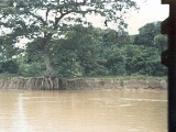
The Apure River is a river of southwestern Venezuela
, formed by the confluence of the Sarare and Uribante near Guasdualito
, in Venezuela, at 7°15′N 70°40′W, and flowing across the llanos
into the Orinoco
. It provides significant transportation in the area.
and only some minor affluents of the Sarare River come from the Cordillera Oriental in the Colombia
n Andes
, entering Venezuela at the confluence with the Oirá River which has a very narrow and steep valley and forms the border line between the two countries for a distance of 41 km. The Oirá River starts in Venezuela and its thalweg
forms that border for several kilometres downstream. The Uribante River is longer than the Sarare and flows from the Táchira-Mérida border, near the town of Pregonero
. The Apure's drainage area thus includes the slopes of both the Colombian (less than 0,5 % of its total area) and the Venezuelan Andes.
 From the point where the Uribante joins the Sarare, the Apure flows eastward across the Venezuelan llanos, into the Orinoco. The Apure flows primarily through Apure State including San Fernando
before joining the Orinoco River via six braided river
branches west of Cabruta
, Guárico State, across from Caicara
, Bolívar State, at about 7°40′N 66°25′W. The Apure is 645 miles (1,038 km) long from the Uribante's starting point to the Orinoco. It is navigable for about 500 miles (804.7 km) above the Orinoco, where it has a sluggish course across the llanos
, despite rapids at about the 110 miles (177 km) mark. From the north, its principal tributaries are the Caparo, Portuguesa and Guarico. The Caucagua is its only major tributary from the south. Because of the flatness of the land its meanders and bayous to the south are mingled with those of the Arauca River
creating an extensive area which is flooded annually. However, both rivers keep independent channels during dry season.
Venezuela
Venezuela , officially called the Bolivarian Republic of Venezuela , is a tropical country on the northern coast of South America. It borders Colombia to the west, Guyana to the east, and Brazil to the south...
, formed by the confluence of the Sarare and Uribante near Guasdualito
Guasdualito
Guasdualito is a city in Apure State in Venezuela.Guasdualito has a population of approximately 50,000 inhabitants and is the capital of Páez Municipality in the Distrito Especial Alto Apure...
, in Venezuela, at 7°15′N 70°40′W, and flowing across the llanos
Llanos
The Llanos is a vast tropical grassland plain situated to the east of the Andes in Colombia and Venezuela, in northwestern South America. It is an ecoregion of the Flooded grasslands and savannas Biome....
into the Orinoco
Orinoco
The Orinoco is one of the longest rivers in South America at . Its drainage basin, sometimes called the Orinoquia, covers , with 76.3% of it in Venezuela and the remainder in Colombia...
. It provides significant transportation in the area.
Origin
Most of the streams that ultimately form the Apure originate in the Venezuelan highlands of the Cordillera de MéridaCordillera de Mérida
The Cordillera de Mérida is a series of mountain ranges, or massif, in northwestern Venezuela. The Cordillera de Mérida is a northeastern extension of the Andes Mountains. The ranges run southwest–northeast between the Venezuelan–Colombian border and the Venezuelan coastal range...
and only some minor affluents of the Sarare River come from the Cordillera Oriental in the Colombia
Colombia
Colombia, officially the Republic of Colombia , is a unitary constitutional republic comprising thirty-two departments. The country is located in northwestern South America, bordered to the east by Venezuela and Brazil; to the south by Ecuador and Peru; to the north by the Caribbean Sea; to the...
n Andes
Andes
The Andes is the world's longest continental mountain range. It is a continual range of highlands along the western coast of South America. This range is about long, about to wide , and of an average height of about .Along its length, the Andes is split into several ranges, which are separated...
, entering Venezuela at the confluence with the Oirá River which has a very narrow and steep valley and forms the border line between the two countries for a distance of 41 km. The Oirá River starts in Venezuela and its thalweg
Thalweg
Thalweg in geography and fluvial geomorphology signifies the deepest continuous inline within a valley or watercourse system.-Hydrology:In hydrological and fluvial landforms, the thalweg is a line drawn to join the lowest points along the entire length of a stream bed or valley in its downward...
forms that border for several kilometres downstream. The Uribante River is longer than the Sarare and flows from the Táchira-Mérida border, near the town of Pregonero
Pregonero
Pregonero is a town in Táchira State, Venezuela. It is the administrative centre for Uribante Municipality. Pregonero is located high in the Andes Mountains at an elevation of 1,327 m...
. The Apure's drainage area thus includes the slopes of both the Colombian (less than 0,5 % of its total area) and the Venezuelan Andes.
Course
San Fernando de Apure
San Fernando de Apure is a city in Apure State in Venezuela. The population of the municipality area is 175,056 . The 18th century exports included heron feathers and animal hides....
before joining the Orinoco River via six braided river
Braided river
A braided river is one of a number of channel types and has a channel that consists of a network of small channels separated by small and often temporary islands called braid bars or, in British usage, aits or eyots. Braided streams occur in rivers with high slope and/or large sediment load...
branches west of Cabruta
Cabruta
Cabruta is a fishing town on the Orinoco river in Las Mercedes Municipality, Guárico State, site of a Jesuit mission, and the site of a proposed bridge across the Orinoco to Caicara, Bolívar State.-History:...
, Guárico State, across from Caicara
Caicara del Orinoco
Caicara del Orinoco is a town in, and the administrative seat of, Cedeño Municipality, Bolívar State, Venezuela. It was founded in the middle of the Eighteenth Century.Currently the Venezuelan government is building a bridge across the Orinoco at Caicara...
, Bolívar State, at about 7°40′N 66°25′W. The Apure is 645 miles (1,038 km) long from the Uribante's starting point to the Orinoco. It is navigable for about 500 miles (804.7 km) above the Orinoco, where it has a sluggish course across the llanos
Llanos
The Llanos is a vast tropical grassland plain situated to the east of the Andes in Colombia and Venezuela, in northwestern South America. It is an ecoregion of the Flooded grasslands and savannas Biome....
, despite rapids at about the 110 miles (177 km) mark. From the north, its principal tributaries are the Caparo, Portuguesa and Guarico. The Caucagua is its only major tributary from the south. Because of the flatness of the land its meanders and bayous to the south are mingled with those of the Arauca River
Arauca River
The Arauca River rises in the Andes Mountains of north-central Colombia and ends at the Orinoco in Venezuela. For part of its run it is the boundary between Colombia and Venezuela...
creating an extensive area which is flooded annually. However, both rivers keep independent channels during dry season.