
Lake Ozette
Encyclopedia
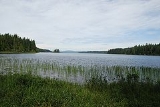
Ozette Lake is the largest unaltered natural lake
in Washington state at 29.5 km² (2,954 ha).
The Makah name for Lake Ozette was Kahouk meaning "large lake." Eight miles long and three miles wide, Ozette Lake is contained within the northern boundary of the Olympic National Park
's coastal strip. It is 29 feet (~9 m) above sea level and is drained by the Ozette River
in the north end. Ozette, Washington
lies at the north end of the lake. At 331 feet deep, its bottom lies more than 300 feet below sea level.
There are three islands on Ozette Lake: Tivoli, Garden Island, and Baby Island. Tivoli's sandy shore is a favorite kayaking and canoeing destination for overnight tent campers willing to make the long trip down the lake. Beware of unpredictable weather conditions, as the large surface of the lake is known to fetch large waves rather quickly.
Ozette Lake features several trails leading to the Pacific Coast Marine Sanctuary. Three of these trails are continuous cedar boardwalks maintained by the Olympic National Park Service. The two most traveled trails depart from the Olympic National Park information kiosks and restrooms at the north end of Ozette Lake. The northern trail, (3.2 miles,) is a cedar boardwalk leading to Cape Alava, passing through the beautiful Ahlstrom's Prairie; the southern boardwalk trail, (3.3 miles,) leads to Sand Point and the Ozette Indian Petroglyphs at Wedding Rock. (54 petroglyphs.) There is a shorter, (2.5 miles,) boat-in only, well-maintained trail that heads out to the wild ocean beaches from Erickson's Bay, on the northwestern side of Ozette Lake. Additional camping at Erickson's Bay, Eagle Point, or Tivoli Island is available for boaters. Longer coastal hiking trails include the Ozette Loop, connecting the Sand Point and Cape Alava trails by hiking up or down the beach to the next trail head. (About 9 miles.)
Two other trails are known to locals and Scout groups; one heading to the beach just south of the Park maintained trail from Erickson's, (Coast Guard Trail,) and a trail from Allen's Bay out to Kayostla Beach. Both trails are undeveloped, known to be frequently muddy, and are recommended for more experienced hikers prepared for wet, wilderness hiking.
The National Park Service maintains 15 sites at the main campground at the north end of the lake. With over 100,000 hikers visiting the "Ozette Loop Trail" yearly, summer campsites fill quickly. There is a parking area to assemble and gather up with your groups. Get there early during peak summer months. Cabin rentals, showers, hot food, cold drinks, local's photos, and information is available just outside the Park boundaries.
Lake
A lake is a body of relatively still fresh or salt water of considerable size, localized in a basin, that is surrounded by land. Lakes are inland and not part of the ocean and therefore are distinct from lagoons, and are larger and deeper than ponds. Lakes can be contrasted with rivers or streams,...
in Washington state at 29.5 km² (2,954 ha).
The Makah name for Lake Ozette was Kahouk meaning "large lake." Eight miles long and three miles wide, Ozette Lake is contained within the northern boundary of the Olympic National Park
Olympic National Park
Olympic National Park is located in the U.S. state of Washington, in the Olympic Peninsula. The park can be divided into four basic regions: the Pacific coastline, alpine areas, the west side temperate rainforest and the forests of the drier east side. U.S...
's coastal strip. It is 29 feet (~9 m) above sea level and is drained by the Ozette River
Ozette River
The Ozette River is a stream on the Olympic Peninsula in the U.S. state of Washington. It originates in the northwestern Olympic Mountains and empties into the Pacific Ocean.-Course:...
in the north end. Ozette, Washington
Ozette, Washington
Ozette is an unincorporated community in Clallam County, Washington, United States. At 124 degrees, 40 minutes, 1 second West longitude, it is the westernmost populated area in the contiguous United States. The 22 mile long Hoko-Ozette Road, accessed via Washington State Route 112, terminates at...
lies at the north end of the lake. At 331 feet deep, its bottom lies more than 300 feet below sea level.
There are three islands on Ozette Lake: Tivoli, Garden Island, and Baby Island. Tivoli's sandy shore is a favorite kayaking and canoeing destination for overnight tent campers willing to make the long trip down the lake. Beware of unpredictable weather conditions, as the large surface of the lake is known to fetch large waves rather quickly.
Ozette Lake features several trails leading to the Pacific Coast Marine Sanctuary. Three of these trails are continuous cedar boardwalks maintained by the Olympic National Park Service. The two most traveled trails depart from the Olympic National Park information kiosks and restrooms at the north end of Ozette Lake. The northern trail, (3.2 miles,) is a cedar boardwalk leading to Cape Alava, passing through the beautiful Ahlstrom's Prairie; the southern boardwalk trail, (3.3 miles,) leads to Sand Point and the Ozette Indian Petroglyphs at Wedding Rock. (54 petroglyphs.) There is a shorter, (2.5 miles,) boat-in only, well-maintained trail that heads out to the wild ocean beaches from Erickson's Bay, on the northwestern side of Ozette Lake. Additional camping at Erickson's Bay, Eagle Point, or Tivoli Island is available for boaters. Longer coastal hiking trails include the Ozette Loop, connecting the Sand Point and Cape Alava trails by hiking up or down the beach to the next trail head. (About 9 miles.)
Two other trails are known to locals and Scout groups; one heading to the beach just south of the Park maintained trail from Erickson's, (Coast Guard Trail,) and a trail from Allen's Bay out to Kayostla Beach. Both trails are undeveloped, known to be frequently muddy, and are recommended for more experienced hikers prepared for wet, wilderness hiking.
The National Park Service maintains 15 sites at the main campground at the north end of the lake. With over 100,000 hikers visiting the "Ozette Loop Trail" yearly, summer campsites fill quickly. There is a parking area to assemble and gather up with your groups. Get there early during peak summer months. Cabin rentals, showers, hot food, cold drinks, local's photos, and information is available just outside the Park boundaries.