
Novo Brasil
Encyclopedia
| Novo Brasil | |
|---|---|
| State | Goiás Goiás Goiás is a state of Brazil, located in the central part of the country. The name Goiás comes from the name of an indigenous community... |
| Coordinatates | 16°02′16"S 50°42′21"W |
| Area: | 649.9 km² (10/10/2002) |
| Population: | 3,451 (IBGE 2007) |
| Urban population: | 2,208 (2007) |
| Population density: | 5.31 inhab/km² (2007) |
| Elevation: | 400m above sea level |
| Postcode (CEP): | 76285-000 |
| Became a city: | 1958 |
| Mayor: | José Fabiano Alves de Castro (January 2005) |
| IBGE statistical Microregion: | Iporá Microregion Iporá Microregion The Iporá Microregion is a geographical region in central-western Goiás state, Brazil. The most important city is Iporá. For a map see -Important Data :*Population: 58,845 *Cities: 10*Total Area: 7,096.60 km²... |
| Distance to Goiânia Goiânia -Climate:The city has a tropical wet and dry climate with an average temperature of . There's a wet season, from October to April, and a dry one, from May to September. Annual rainfall is around 1,520 mm.... : |
200 km. |
| Website: | none (March 2008) |
Town
A town is a human settlement larger than a village but smaller than a city. The size a settlement must be in order to be called a "town" varies considerably in different parts of the world, so that, for example, many American "small towns" seem to British people to be no more than villages, while...
and municipality
Municipality
A municipality is essentially an urban administrative division having corporate status and usually powers of self-government. It can also be used to mean the governing body of a municipality. A municipality is a general-purpose administrative subdivision, as opposed to a special-purpose district...
in eastern Goiás
Goiás
Goiás is a state of Brazil, located in the central part of the country. The name Goiás comes from the name of an indigenous community...
state, Brazil
Brazil
Brazil , officially the Federative Republic of Brazil , is the largest country in South America. It is the world's fifth largest country, both by geographical area and by population with over 192 million people...
.
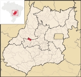
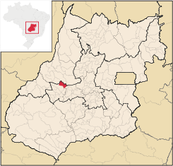
Location
Novo Brasil is located east of the capital near IporáIporá
Iporá is a small city and municipality in west-central Goiás state, Brazil. The population was 31,060 in a total area of 1,026.4 km² . It is known as the City of the Clear Waters because of its many streams and rivers.-Location:...
and São Luís de Montes Belos
São Luís de Montes Belos
São Luís de Montes Belos is a small city and municipality in the State of Goiás, Brazil.-Location:It is located in the Anicuns Microregion, 123 kilometers from the state capital, Goiânia, to which it is connected by highway GO-060...
.
- Distance to the state capital: 200 km.
- Distance to regional center, São Luís de Montes BelosSão Luís de Montes BelosSão Luís de Montes Belos is a small city and municipality in the State of Goiás, Brazil.-Location:It is located in the Anicuns Microregion, 123 kilometers from the state capital, Goiânia, to which it is connected by highway GO-060...
: 77 km. - Highway connections from GoiâniaGoiânia-Climate:The city has a tropical wet and dry climate with an average temperature of . There's a wet season, from October to April, and a dry one, from May to September. Annual rainfall is around 1,520 mm....
: state highway BR-069 west from GoiâniaGoiânia-Climate:The city has a tropical wet and dry climate with an average temperature of . There's a wet season, from October to April, and a dry one, from May to September. Annual rainfall is around 1,520 mm....
, through TrindadeTrindade, GoiásTrindade is a city and municipality in Goiás state, Brazil. It is famous for the religious celebrations held there in July and is now the third most important pilgrimage site in Brazil....
/ GO-326 / AnicunsAnicunsAnicuns is a small city and municipality in central Goiás state, Brazil.-Geographical Facts:Anicuns is located in the Anicuns Microregion, which includes 13 cities with a population of 103276 inhabitants in a total area of 5483.10 km²....
/ GO-222 / Choupana / GO-326 / SanclerlândiaSanclerlândiaSanclerlândia is a small town and municipality in western Goiás state, Brazil. The population was 7,641 in 2005 and the total area of the municipality was 496.8 km².-Location:...
/ Buriti de GoiásBuriti de GoiásBuriti de Goiás is a small town and municipality in eastern Goiás state, Brazil.-Location and Communications:*Distance to regional center : 58 km....
.
Neighboring municipalities: Fazenda Nova
Fazenda Nova
Fazenda Nova is a small town and municipality in central-west Goiás state, Brazil.-Location:Fazenda Nova is located northwest of the state capital, Goiânia, which is 206 km. away taking highways GO-418 and GO-060...
, Córrego do Ouro
Córrego do Ouro
Córrego do Ouro is a small town and municipality in eastern Goiás state, Brazil.-Location and Highway Connections:Córrego do Ouro is located in the Iporá Microregion west of the state capital, Goiânia. It is 45 km. northwest of São Luís de Montes Belos, the largest town in the region. ...
, Jussara
Jussara
Jussara is a small town and municipality in Goiás state, Brazil. Jussara is a major producer of cattle for the beef market.-Location and history:Jussara is located in the region of the Vale do Araguaia, 222 kilometers from the state capital of Goiânia...
, and Itapirapuã
Itapirapuã
Itapirapuã is a small town and municipality in the state of Goiás in Brazil. The population was 8,208 in 2007 in a total area of 2,043.7 km² . Itapirapuã is a large producer of cattle.-Location and Boundaries:...
Political Information
In January 2005 the Mayor was José Fabiano Alves de Castro. There were 9 city-council members and 3,215 eligible voters in 2007.Demographic Information
In 2007 the population density was 5.31 inhab/km². There were 2,208 inhabitants in the urban area and 1,243 in the rural area. The population has declined by about 1,200 inhabitants since 1980 when it was 4,966. From 2000 to 2007 the population fell 2.7%.Economic Information
The economy was based on services, agriculture, cattle raising, and government employment. In 2005 there were 4 industrial units and 36 retail units. There were no financial institutions. In 2007 there were 250 automobiles, 59 pickups and 410 motorcycles.In 2006 there were 89,240 head of cattle, 27,615 head of poultry, and 4,850 head of swine. The main agricultural products were rice, bananas, manioc, and corn. None exceeded 500 hectares in planted area.
- GDP (PIB) (R$ 1,000.00): 21,711 (2005)
- GDP per capita (R$ 1.00): 5,722 (2005)
Agricultural data 2006
- Farms: 493
- Total area: 35,910 ha.
- Area of permanent crops: 888 ha.
- Area of perennial crops: 124 ha.
- Area of natural pasture: 26,527 ha.
- Area of woodland and forests: 7,206 ha.
- Persons dependent on farming: 1,000
- Farms with tractors: 34
- Number of tractors: 46
- Cattle herd: 92,000 head IBGE
Health and education
In 2007 there was 1 hospital with 27 beds and 2 walk-in health clinics. In 2002 there were 4 doctors, 1 nurse, 1 dentist, and 7 auxiliary nurses. In 2000 the infant mortality rate was 35.47, higher than the national average of 33.0.In 2006 the school system had 6 schools, 27 classrooms, 56 teachers, and 860 students. Of these, 199 were attending a middle school. In 2000 the adult literacy rate was 83.9%, below the national average of 86.4%. In 2000 there were 2,470 students so the number has dropped substantially.
- Municipal Human Development IndexHuman Development IndexThe Human Development Index is a composite statistic used to rank countries by level of "human development" and separate "very high human development", "high human development", "medium human development", and "low human development" countries...
: 0.713 - State ranking: 193 (out of 442 municipalities)
- National ranking: 2.763 (out of 5,507 municipalities)
History
The settlement of this region began in 1949 when a group of farmers from Paraná arrived and settled between the Bocaina and Carapuça rivers. In 1953 the town achieved some prosperity and became known as Novo Brasil. In 1958 it became a district of Fazenda NovaFazenda Nova
Fazenda Nova is a small town and municipality in central-west Goiás state, Brazil.-Location:Fazenda Nova is located northwest of the state capital, Goiânia, which is 206 km. away taking highways GO-418 and GO-060...
. In the same year it was dismembered and made a municipality.