
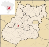
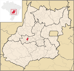
Córrego do Ouro
Encyclopedia
| Córrego do Ouro | |
|---|---|
| State | Goiás Goiás Goiás is a state of Brazil, located in the central part of the country. The name Goiás comes from the name of an indigenous community... |
| Coordinates: | 16°38′50"S 50°32′52"W |
| Area: | 463.9 km² |
| Population: | 2,633 (IBGE 2007) |
| Population density: | 5.70 inhab/km² (2007) |
| Elevation: | 563 m above sea level |
| Postcode (CEP): | 76145-000 |
| Became a city: | 1953 |
| Mayor: | Bento Vicente Da Silva |
| Distance to Goiânia Goiânia -Climate:The city has a tropical wet and dry climate with an average temperature of . There's a wet season, from October to April, and a dry one, from May to September. Annual rainfall is around 1,520 mm.... : |
171 km. |
| IBGE statistical microregion: | Iporá Microregion Iporá Microregion The Iporá Microregion is a geographical region in central-western Goiás state, Brazil. The most important city is Iporá. For a map see -Important Data :*Population: 58,845 *Cities: 10*Total Area: 7,096.60 km²... |
| Website: | none (24/03/2008 |
Town
A town is a human settlement larger than a village but smaller than a city. The size a settlement must be in order to be called a "town" varies considerably in different parts of the world, so that, for example, many American "small towns" seem to British people to be no more than villages, while...
and municipality
Municipality
A municipality is essentially an urban administrative division having corporate status and usually powers of self-government. It can also be used to mean the governing body of a municipality. A municipality is a general-purpose administrative subdivision, as opposed to a special-purpose district...
in eastern Goiás
Goiás
Goiás is a state of Brazil, located in the central part of the country. The name Goiás comes from the name of an indigenous community...
state, Brazil
Brazil
Brazil , officially the Federative Republic of Brazil , is the largest country in South America. It is the world's fifth largest country, both by geographical area and by population with over 192 million people...
.
Location and Highway Connections
Córrego do Ouro is located in the Iporá MicroregionIporá Microregion
The Iporá Microregion is a geographical region in central-western Goiás state, Brazil. The most important city is Iporá. For a map see -Important Data :*Population: 58,845 *Cities: 10*Total Area: 7,096.60 km²...
west of the state capital, Goiânia
Goiânia
-Climate:The city has a tropical wet and dry climate with an average temperature of . There's a wet season, from October to April, and a dry one, from May to September. Annual rainfall is around 1,520 mm....
. It is 45 km. northwest of São Luís de Montes Belos
São Luís de Montes Belos
São Luís de Montes Belos is a small city and municipality in the State of Goiás, Brazil.-Location:It is located in the Anicuns Microregion, 123 kilometers from the state capital, Goiânia, to which it is connected by highway GO-060...
, the largest town in the region. Goiânia lies at a distance of 171 km. Highway connections from Goiânia
Goiânia
-Climate:The city has a tropical wet and dry climate with an average temperature of . There's a wet season, from October to April, and a dry one, from May to September. Annual rainfall is around 1,520 mm....
were made by GO-060 / Trindade
Trindade, Goiás
Trindade is a city and municipality in Goiás state, Brazil. It is famous for the religious celebrations held there in July and is now the third most important pilgrimage site in Brazil....
/ Claudinápolis (district) / GO-326 / Anicuns
Anicuns
Anicuns is a small city and municipality in central Goiás state, Brazil.-Geographical Facts:Anicuns is located in the Anicuns Microregion, which includes 13 cities with a population of 103276 inhabitants in a total area of 5483.10 km²....
/ GO-222 / GO-326 / Sanclerlândia
Sanclerlândia
Sanclerlândia is a small town and municipality in western Goiás state, Brazil. The population was 7,641 in 2005 and the total area of the municipality was 496.8 km².-Location:...
/ Buriti de Goiás
Buriti de Goiás
Buriti de Goiás is a small town and municipality in eastern Goiás state, Brazil.-Location and Communications:*Distance to regional center : 58 km....
/ GO-518. Seplan. Neighboring municipalities: Moiporá
Moiporá
Moiporá is a small town and municipality in eastern Goiás state, Brazil.-Distances and Highway Connections:*Distance to the state capital: 160 km.*Distance to regional center : 76 km....
, Israelândia
Israelândia
Israelândia is a small town and municipality in eastern Goiás state, Brazil.-Location:Israelândia is located in the Iporá Microregion, 28 km. northeast of regional center Iporá. State capital Goiânia is 199 km. to the east...
, Fazenda Nova
Fazenda Nova
Fazenda Nova is a small town and municipality in central-west Goiás state, Brazil.-Location:Fazenda Nova is located northwest of the state capital, Goiânia, which is 206 km. away taking highways GO-418 and GO-060...
, Novo Brasil
Novo Brasil
Novo Brasil is a small town and municipality in eastern Goiás state, Brazil.-Location:Novo Brasil is located east of the capital near Iporá and São Luís de Montes Belos.*Distance to the state capital: 200 km....
, Buriti de Goiás
Buriti de Goiás
Buriti de Goiás is a small town and municipality in eastern Goiás state, Brazil.-Location and Communications:*Distance to regional center : 58 km....
, and Adelândia
Adelândia
Adelândia is a small town and municipality in eastern Goiás state, Brazil.-Location:The distance to the state capital Goiânia is 129 km. while the distance to the regional center São Luís de Montes Belos is 6 km....
Demographics
- Population in 1980: 4,367
- Population in 2007: 2,633
- Urban population: 1,571
- Rural population: 1,062
- Population growth rate: -1.77%
The economy
The main economic activities were cattle raising (64,200 in 2006) and agriculture. Main crops were rice, bananas, and corn. There was one dairy: Laticínios Farlat - Indústria e Comércio Ltda (2007)- GDP (R$ 1,000.00) in 2005: 18,252
- Per capita GDP (R$ 1.00) n 2005: 6,577
Agricultural data 2006
- Farms: 368
- Total area: 40,656 ha.
- Area of permanent crops: 299 ha.
- Area of perennial crops: 496 ha.
- Area of natural pasture: 29,174 ha.
- Area of woodland and forests: 9,691 ha.
- Persons dependent on farming: 900
- Farms with tractors: 27
- Number of tractors: 29
- Cattle herd: 54,200 head
Health and education
- Literacy rate: 85.6% (2000)
- Schools: 04 (2007)
- Students: 728
- Infant mortality rate: 27.14 in 1,000 live births (2000)
- Hospitals: 01 with 16 beds
- Municipal Human Development IndexHuman Development IndexThe Human Development Index is a composite statistic used to rank countries by level of "human development" and separate "very high human development", "high human development", "medium human development", and "low human development" countries...
: 0.726
History
The history of Córrego do Ouro began in 1934 with the dynamism of Padre Alexandre Pereira. A bridge was built across the Rio Fartura and the population began to grow. In 1948 it was raised to the status of district belonging to Goiás to be granted autonomy in 1953.See also
List of municipalities in GoiásMicroregions of Goiás