
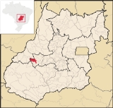
Iporá
Encyclopedia
| Iporá | |
|---|---|
| State | Goiás Goiás Goiás is a state of Brazil, located in the central part of the country. The name Goiás comes from the name of an indigenous community... |
| Area: | 1,026.4 km² |
| Population: | 31,060 (IBGE 2007) |
| Elevation: | 584 m above sea level |
| Postcode (CEP): | 76200-000 |
| Became a city: | 1948 |
| Distance to Goiânia Goiânia -Climate:The city has a tropical wet and dry climate with an average temperature of . There's a wet season, from October to April, and a dry one, from May to September. Annual rainfall is around 1,520 mm.... : |
225 km. |
| IBGE statistical microregion: | Iporá Microregion Iporá Microregion The Iporá Microregion is a geographical region in central-western Goiás state, Brazil. The most important city is Iporá. For a map see -Important Data :*Population: 58,845 *Cities: 10*Total Area: 7,096.60 km²... |
| Website: | Prefeitura Municipal de Iporá |
| Coordinates: | 16°26′28"S 51°07′10"W |
City
A city is a relatively large and permanent settlement. Although there is no agreement on how a city is distinguished from a town within general English language meanings, many cities have a particular administrative, legal, or historical status based on local law.For example, in the U.S...
and municipality
Municipality
A municipality is essentially an urban administrative division having corporate status and usually powers of self-government. It can also be used to mean the governing body of a municipality. A municipality is a general-purpose administrative subdivision, as opposed to a special-purpose district...
in west-central Goiás
Goiás
Goiás is a state of Brazil, located in the central part of the country. The name Goiás comes from the name of an indigenous community...
state, Brazil
Brazil
Brazil , officially the Federative Republic of Brazil , is the largest country in South America. It is the world's fifth largest country, both by geographical area and by population with over 192 million people...
. The population was 31,060 (2007) in a total area of 1,026.4 km² (10/10/2002). It is known as the City of the Clear Waters because of its many streams and rivers.
Location
Iporá is the center of the Iporá MicroregionIporá Microregion
The Iporá Microregion is a geographical region in central-western Goiás state, Brazil. The most important city is Iporá. For a map see -Important Data :*Population: 58,845 *Cities: 10*Total Area: 7,096.60 km²...
. The distance to the state capital, Goiânia
Goiânia
-Climate:The city has a tropical wet and dry climate with an average temperature of . There's a wet season, from October to April, and a dry one, from May to September. Annual rainfall is around 1,520 mm....
, is 225 km. and connections are made by highway GO-060 passing through / Trindade
Trindade, Goiás
Trindade is a city and municipality in Goiás state, Brazil. It is famous for the religious celebrations held there in July and is now the third most important pilgrimage site in Brazil....
/ Turvânia
Turvânia
Turvânia is a small town and municipality in eastern Goiás state, Brazil.-Location:Turvânia is located west of Goiânia, east of São Luís de Montes Belos....
/ Firminópolis
Firminópolis
Firminópolis is a small town and municipality in eastern Goiás state, Brazil.-Location and connections:*Distance to São Luís de Montes Belos: 9 km....
/ Israelândia
Israelândia
Israelândia is a small town and municipality in eastern Goiás state, Brazil.-Location:Israelândia is located in the Iporá Microregion, 28 km. northeast of regional center Iporá. State capital Goiânia is 199 km. to the east...
.
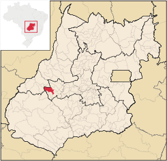
The municipal boundaries in the north are with Diorama
Diorama, Goiás
Diorama is a small town and municipality in eastern Goiás state, Brazil.-Location and Connections:Diorama is 254 kilometers west of the state capital, Goiânia, and is 30 kilometers west of the regional center, Iporá...
, Jaupaci
Jaupaci
Jaupaci is a small town and municipality in eastern Goiás state, Brazil. The population was 2,998 in a total area of 527.2 km² .-Location:*Distance to regional center : 46 km....
and Israelândia
Israelândia
Israelândia is a small town and municipality in eastern Goiás state, Brazil.-Location:Israelândia is located in the Iporá Microregion, 28 km. northeast of regional center Iporá. State capital Goiânia is 199 km. to the east...
; in the south with Amorinópolis
Amorinópolis
Amorinópolis is a small town and municipality in eastern Goiás state, Brazil.-Location:The distance to the regional center of is 19 km....
and Ivolândia; in the east with Moiporá
Moiporá
Moiporá is a small town and municipality in eastern Goiás state, Brazil.-Distances and Highway Connections:*Distance to the state capital: 160 km.*Distance to regional center : 76 km....
and Ivolândia
Ivolândia
Ivolândia is a small town and municipality in eastern Goiás state, Brazil. The population was 2,718 in a total area of 1,262.8 km² .-Location:*Distance to regional center : 56 km....
; and in the west with Arenópolis
Arenópolis
Arenópolis is a small town and municipality in eastern Goiás state, Brazil. The population was 3,495 in a total area of 1,074.5 km².-Location and Connections with Goiânia:...
.
Geography and climate
There are low mountains: Serra do Caiapó, Serra dos Pilões, Serra do Rio Claro, and Morro do Macaco, where there are deposits of nickel.The region has a tropical climate, hot and semi-moist, with two well defined seasons: humid, from October to March, with torrential rains, corresponding to spring and summer and known as the season of the waters; and dry, from April to September, corresponding to autumn and winter, known as the dry season. The temperature varies between the average minimum of 18°C and the average maximum of 26°C. Annual rainfall is 1,500 cubic milliliters.
Districts, Villages, and Hamlets
- Hamlets: Cocalândia, Cruzeirinho and Jacinópolis
Political and Demographic Data
- Eligible voters: 23,813 (11/2007)
- Mayor: Mac Mahoen Távora Diniz (January 2005)
- Vice-mayor: Auelione Alves da Silva
- Councilmembers: 09
- Population growth rate 2000/2007: -0.11.%
- Population in 1980: 27,248
- Population in 2007: 31,060
- Urban population in 2007: 28,316
- Rural population in 2007: 2,744 (Sepin)
Economy
Commerce is the main economic activity with over 458 enterprises registered (2007). Cattle raising is also important with 92,000 head registered. The dairy industry (16,000 milking cows) is especially vibrant with three milk companies operating in the region. In addition there is a large poultry industry with 70,000 birds registered in 2006. The main agricultural products were corn (1,300 hectares), manioc, rice, bananas, and soy beans (1,000 hectares).Economic Data
- Industrial units: 59 (06/2007)
- Retail units: 458 (2007)
- Banking institutions: - Banco do Brasil S.A. - BRADESCO S.A. - Banco Itaú S.A. - CEF - (08/2007)
- Dairies: Laticínios Morrinhos Ind. e Com. Ltda.; - Laticínios Caetano Ltda (08/2007)
- Industrial zone: Distrito Agroindustrial - DAIPO (Jan/2005)
- GDP (PIB)(R$ 1,000.00): 157,759 (2005)
Motor Vehicles
- Automobiles: 4,526
- Pickup trucks: 1,146
- Number of inhabitants per motor vehicle: 5.4
There were 5,781 motorcycles and motorbikes in the city in 2007.
Agricultural data 2006
- Farms: 1,002
- Total area: 84,199 ha.
- Area of permanent crops: 134 ha.
- Area of perennial crops: 2,051 ha.
- Area of natural pasture: 68,057 ha.
- Area of woodland and forests: 12,073 ha.
- Persons dependent on farming: 2,700
- Farms with tractors: 94
- Number of tractors: 120
- Cattle herd: 92,000 head IBGE
Main crops in hectares 2006
- Rice: 250
- Banana: 34
- Sugarcane: 10
- Coconut: 9
- Manioc: 300
- Corn: 1,200
- Soybeans: 1,000
- Sorghum: 220
Education and Health
- Literacy rate: 87.5%
- Infant mortality rate: 17.12 in 1,000 live births
- Schools: 33 (2007)
- Students: 9,145
- Higher education: UEG - Faculdade de Educação, Ciências e Letras - de Iporá - Faculdade de Iporá-FAI
- Hospitals: 05 (02/2007)
- Hospital beds: 203
(Sepin)
- Municipal Human Development IndexHuman Development IndexThe Human Development Index is a composite statistic used to rank countries by level of "human development" and separate "very high human development", "high human development", "medium human development", and "low human development" countries...
: 0.780 - State ranking: 32 (out of 442 municipalities in 2000)
- National ranking: 1,074 (out of 5,507 municipalities in 2000)
For the complete list see Frigoletto.com.br