

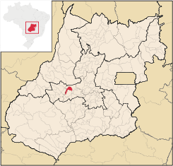
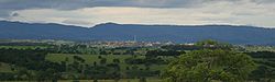
Sanclerlândia
Encyclopedia
| Sanclerlândia | |
|---|---|
| State | Goiás Goiás Goiás is a state of Brazil, located in the central part of the country. The name Goiás comes from the name of an indigenous community... |
| Area: | 496.8 km² |
| Population: | 7,647 (IBGE 2007) |
| Elevation: | 607m above sea level |
| Postcode (CEP): | 76160-000 |
| IBGE statistical microregion: | Anicuns Microregion Anicuns Microregion The Anicuns Microregion is a geographical division in the state of Goiás, Brazil. It is made up of 13 municipalities located near Anicuns, a small city and municipality west of Goiânia... |
| Became a city: | 1963 |
| Mayor: | Itamar Leão do Amaral |
| Distance to Goiânia Goiânia -Climate:The city has a tropical wet and dry climate with an average temperature of . There's a wet season, from October to April, and a dry one, from May to September. Annual rainfall is around 1,520 mm.... : |
134 km. |
| Website: | none |
| Geographical coordinates: | 16°12′06"S 50°18′39"W |
Town
A town is a human settlement larger than a village but smaller than a city. The size a settlement must be in order to be called a "town" varies considerably in different parts of the world, so that, for example, many American "small towns" seem to British people to be no more than villages, while...
and municipality
Municipality
A municipality is essentially an urban administrative division having corporate status and usually powers of self-government. It can also be used to mean the governing body of a municipality. A municipality is a general-purpose administrative subdivision, as opposed to a special-purpose district...
in western Goiás
Goiás
Goiás is a state of Brazil, located in the central part of the country. The name Goiás comes from the name of an indigenous community...
state, Brazil
Brazil
Brazil , officially the Federative Republic of Brazil , is the largest country in South America. It is the world's fifth largest country, both by geographical area and by population with over 192 million people...
. The population was 7,641 in 2005 and the total area of the municipality was 496.8 km².
Location
Sanclerlândia belongs to the Anicuns MicroregionAnicuns Microregion
The Anicuns Microregion is a geographical division in the state of Goiás, Brazil. It is made up of 13 municipalities located near Anicuns, a small city and municipality west of Goiânia...
and is northwest of the state capital, Goiânia
Goiânia
-Climate:The city has a tropical wet and dry climate with an average temperature of . There's a wet season, from October to April, and a dry one, from May to September. Annual rainfall is around 1,520 mm....
. It has paved road connections with Itaberaí
Itaberaí
Itaberaí is a small city and municipality in central Goiás state, Brazil. Itaberaí is a large producer of agricultural products including corn, rice, soybeans, tomatoes, and sugarcane.-Location:...
and São Luís de Montes Belos
São Luís de Montes Belos
São Luís de Montes Belos is a small city and municipality in the State of Goiás, Brazil.-Location:It is located in the Anicuns Microregion, 123 kilometers from the state capital, Goiânia, to which it is connected by highway GO-060...
. Neighboring municipalities are Buriti de Goiás
Buriti de Goiás
Buriti de Goiás is a small town and municipality in eastern Goiás state, Brazil.-Location and Communications:*Distance to regional center : 58 km....
, Mossâmedes
Mossâmedes
Mossâmedes is a small town and municipality in western Goiás state, Brazil.-Location:Mossâmedes is located northwest of the state capital, Goiânia in the Anicuns Microregion. It is connected by paved roads with Itaberaí to the north and Anicuns to the south. The distance to the state capital is...
, São Luís de Montes Belos
São Luís de Montes Belos
São Luís de Montes Belos is a small city and municipality in the State of Goiás, Brazil.-Location:It is located in the Anicuns Microregion, 123 kilometers from the state capital, Goiânia, to which it is connected by highway GO-060...
, Adelândia
Adelândia
Adelândia is a small town and municipality in eastern Goiás state, Brazil.-Location:The distance to the state capital Goiânia is 129 km. while the distance to the regional center São Luís de Montes Belos is 6 km....
, and Córrego do Ouro
Córrego do Ouro
Córrego do Ouro is a small town and municipality in eastern Goiás state, Brazil.-Location and Highway Connections:Córrego do Ouro is located in the Iporá Microregion west of the state capital, Goiânia. It is 45 km. northwest of São Luís de Montes Belos, the largest town in the region. ...
. The distance to Goiânia
Goiânia
-Climate:The city has a tropical wet and dry climate with an average temperature of . There's a wet season, from October to April, and a dry one, from May to September. Annual rainfall is around 1,520 mm....
is 134 km. Highway connections are made by GO-060 / Trindade
Trindade, Goiás
Trindade is a city and municipality in Goiás state, Brazil. It is famous for the religious celebrations held there in July and is now the third most important pilgrimage site in Brazil....
/ GO-326 / Anicuns
Anicuns
Anicuns is a small city and municipality in central Goiás state, Brazil.-Geographical Facts:Anicuns is located in the Anicuns Microregion, which includes 13 cities with a population of 103276 inhabitants in a total area of 5483.10 km²....
/ GO-222 / GO-326 / Choupana.
Demographics
The population density was 15.39 inhab/km² (2007). There were 6,038 people living in urban areas and 1,609 living in rural areas (2007). Over the past two years the population has risen due to the establishment of several new industries in the town.The economy
The economy consists primalriy on the production from the agriculture farms surrounding the town (rice, bananas, and corn), cattle raising is a major cornerstone to the local economy (74,170 head in 2006). In addition there are numerous services in public administration, and small locally run industries. In 2007 there were three financial institutions. The main industries established in the town are, LeitBom milk factory (being the largest and longest established industry in the town) followed by several medium sized clothing factories producing a wide range of clothing for nationally known labels.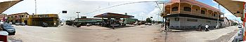
Health and education
In the educational area there is a small campus of the UEG - faculdade Estadual de Agronomia e Zootecnia de Sanclerlândia. The adult literacy rate was 85.3% (2000) (national average was 86.4%). In 2006 there were 2 hospitals with 63 beds. The infant mortality rate was 23.49 (2000) (the national average was 33.0)- The Municipal Human Development IndexHuman Development IndexThe Human Development Index is a composite statistic used to rank countries by level of "human development" and separate "very high human development", "high human development", "medium human development", and "low human development" countries...
was 0.734 - State ranking: 129 (out of 242 municipalities)
- National ranking: 2,324 (out of 5,507 municipalities)
History
Sanclerlândia was founded in 1943 with a handful of people settling along the highway connecting GoiâniaGoiânia
-Climate:The city has a tropical wet and dry climate with an average temperature of . There's a wet season, from October to April, and a dry one, from May to September. Annual rainfall is around 1,520 mm....
and Córrego do Ouro
Córrego do Ouro
Córrego do Ouro is a small town and municipality in eastern Goiás state, Brazil.-Location and Highway Connections:Córrego do Ouro is located in the Iporá Microregion west of the state capital, Goiânia. It is 45 km. northwest of São Luís de Montes Belos, the largest town in the region. ...
. The first few dwellings were simple and consisted of several homes and a general store. Soon other homes appeared and the town quickly took shape drawing more and more people to the area. In 1958, the settlement was called Officially named Sanclerlândia. The municipality received emancipation in 1963. Today the city is most commonly known for the statewide competition hosted there every year called "Jeep Cross" the annual Jeep Competition.