

Far North District
Encyclopedia
New Zealand
New Zealand is an island country in the south-western Pacific Ocean comprising two main landmasses and numerous smaller islands. The country is situated some east of Australia across the Tasman Sea, and roughly south of the Pacific island nations of New Caledonia, Fiji, and Tonga...
, as its name suggests, is the northernmost district within New Zealand
New Zealand
New Zealand is an island country in the south-western Pacific Ocean comprising two main landmasses and numerous smaller islands. The country is situated some east of Australia across the Tasman Sea, and roughly south of the Pacific island nations of New Caledonia, Fiji, and Tonga...
, consisting of the northern tip of the North Island
North Island
The North Island is one of the two main islands of New Zealand, separated from the much less populous South Island by Cook Strait. The island is in area, making it the world's 14th-largest island...
. The current mayor is Wayne Brown.
Geography
This is the largest of three territorial authoritiesTerritorial authorities of New Zealand
Territorial authorities are the second tier of local government in New Zealand, below regional councils. There are 67 territorial authorities: 13 city councils, 53 district councils, and the Chatham Islands Council...
making up the Northland region. The district stretches from the capes and bays at the northern tip of the Aupouri Peninsula
Aupouri Peninsula
The Aupouri Peninsula is a tombolo at the northern tip of the North Island of New Zealand. It projects between the Tasman Sea to the west and the Pacific Ocean to the east...
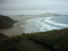
past Ninety Mile Beach
Ninety Mile Beach, New Zealand
Ninety Mile Beach is a beach located on the western coast of the far north of the North Island of New Zealand. It stretches from just west of Kaitaia towards Cape Reinga along the Aupouri Peninsula. It begins close to the headland of Reef Point, to the west of Ahipara Bay, sweeping briefly...
to the main body of the North Auckland Peninsula
North Auckland Peninsula
The North Auckland Peninsula, frequently referred to simply as the Northland Peninsula, is located in the far north of the North Island of New Zealand. The peninsula is easily confused with, though not the same as Northland Region, which occupies the top 80% of the peninsula...
, where it encompasses both the Bay of Islands
Bay of Islands
The Bay of Islands is an area in the Northland Region of the North Island of New Zealand. Located 60 km north-west of Whangarei, it is close to the northern tip of the country....
and Hokianga
Hokianga
Hokianga is an area surrounding the Hokianga Harbour, also known as The Hokianga River, a long estuarine drowned valley on the west coast in the north of the North Island of New Zealand....
.
It borders on the Kaipara
Kaipara District
-Geography:Kaipara District is located in the low hills around the northern shores of the Kaipara Harbour, a large natural harbour open to the Tasman Sea...
and Whangarei Districts, which are the other two territorial authorities in the Northland Region.
Population
Northernmost town in the district is KaitaiaKaitaia
Kaitaia is a town in the far north region of New Zealand, at the base of the Aupouri Peninsula which is about 160 km northwest of Whangarei. It is the last major settlement on the main road north to the capes and bays on the peninsula...
. There is a cluster of towns on the east coast around the Bay of Islands
Bay of Islands
The Bay of Islands is an area in the Northland Region of the North Island of New Zealand. Located 60 km north-west of Whangarei, it is close to the northern tip of the country....
, (Kerikeri
Kerikeri
Kerikeri, the largest town in the Northland Region of New Zealand, is a popular tourist destination about three hours drive north of Auckland, and 80 km north of Whangarei...
, Paihia
Paihia
Paihia is the main tourist town in the Bay of Islands in the far north of the North Island of New Zealand. It is located close to the historic towns of Russell, and Kerikeri, 60 kilometres north of Whangarei. The origin of the name Paihia is obscure. One, possibily apocryphal, attribution is to...
, Russell
Russell, New Zealand
Russell, formerly known as Kororareka, was the first permanent European settlement and sea port in New Zealand. It is situated in the Bay of Islands, in the far north of the North Island. As at the 2006 census it had a resident population of 816, an increase of 12 from 2001...
, Opua
Opua
Opua is a locality in the Bay of Islands, in the sub-tropical Northland Region of New Zealand. It is notable as the first port for overseas yachts arriving in the country after crossing the Pacific Ocean...
, Kawakawa
Kawakawa, New Zealand
Kawakawa is a small town in the Northland Region of northern New Zealand. It had a population of 1347 at the 2006 census, down from 1401 in 2001. Kawakawa developed as a service town when coal was found in the area in 1861, but there is no longer coal mining here...
and Moerewa
Moerewa
Moerewa is a small town in the Northland Region of the North Island of New Zealand. It is unusual for its high proportion of Māori - over 80% of the population...
), the town of Kaikohe
Kaikohe
Kaikohe is the central service area for the Far North District of New Zealand, about 260 km from Auckland, situated on State Highway 12 at...
centrally situated to the west of them, and a cluster of small settlements on the west coast surrounding the Hokianga Harbour
Hokianga
Hokianga is an area surrounding the Hokianga Harbour, also known as The Hokianga River, a long estuarine drowned valley on the west coast in the north of the North Island of New Zealand....
(Omapere, Opononi
Opononi
Opononi is a settlement on the south shore of the Hokianga harbour in Northland Region, New Zealand. State Highway 12 runs through Opononi. Omapere lies to the south and Whirinaki lies to the north east....
, Rawene
Rawene
Rawene is a town on the south side of the Hokianga harbour, in Northland, New Zealand. State Highway 12 passes to the south. The town lies at the apex of a peninsula...
, Panguru
Panguru
Panguru is a community in the northern Hokianga harbour, in Northland, New Zealand. The Whakarapa Stream flows from the Panguru Range in the Warawara Forest to the west, through Panguru and into the Hokianga...
, Kohukohu
Kohukohu, New Zealand
Kohukohu is an historic village on the Hokianga Harbour in the far north of the North Island. It was one of the first European settlements in New Zealand....
, and Horeke
Horeke
Horeke is a settlement in the upper reaches of the Hokianga harbour in Northland, New Zealand. Kohukohu is just across the harbour. The Wairere Boulders is located in the Hokianga Harbour near the town .-History:...
).
The district has of whom 40 percent are Māori. Over the last 10 years the district's population has defied national (and worldwide) trends by becoming increasingly rural. The largest town is Kerikeri with a population of 5856, followed by Kaitaia with 5202, and Kaikohe, the seat of the District Council, with 4113.