

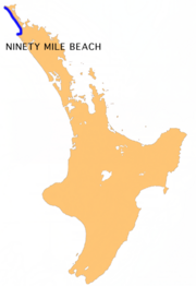
Ninety Mile Beach, New Zealand
Encyclopedia
North Island
The North Island is one of the two main islands of New Zealand, separated from the much less populous South Island by Cook Strait. The island is in area, making it the world's 14th-largest island...
of New Zealand
New Zealand
New Zealand is an island country in the south-western Pacific Ocean comprising two main landmasses and numerous smaller islands. The country is situated some east of Australia across the Tasman Sea, and roughly south of the Pacific island nations of New Caledonia, Fiji, and Tonga...
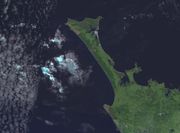
. It stretches from just west of Kaitaia
Kaitaia
Kaitaia is a town in the far north region of New Zealand, at the base of the Aupouri Peninsula which is about 160 km northwest of Whangarei. It is the last major settlement on the main road north to the capes and bays on the peninsula...
towards Cape Reinga
Cape Reinga
Cape Reinga is the northwesternmost tip of the Aupouri Peninsula, at the northern end of the North Island of New Zealand. Cape Reinga is located over 100 km north of the nearest small town of Kaitaia. State Highway 1 extends all the way to the Cape, but until 2010 was unsealed gravel road for the...
along the Aupouri Peninsula
Aupouri Peninsula
The Aupouri Peninsula is a tombolo at the northern tip of the North Island of New Zealand. It projects between the Tasman Sea to the west and the Pacific Ocean to the east...
. It begins close to the headland of Reef Point, to the west of Ahipara Bay, sweeping briefly northeast before turning northwest for the majority of its length. It ends at Scott Point, five km south of Cape Maria van Diemen
Cape Maria van Diemen
Cape Maria van Diemen is the westernmost point of the North Island of New Zealand. Being close to the northern tip of the Aupouri Peninsula, many people in New Zealand also incorrectly believe it to be the northernmost point...
.
Etymology
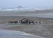
The name Ninety Mile Beach is a misnomer because it is actually 55 miles (88 km) long. Several theories have been advanced for the name, the most common stemming from the days when missionaries travelled on horse back when on average a horse could travel 30 miles (48.3 km) in a day before needing to be rested. The beach took three days to travel therefore earning its name, but the missionaries did not take into account the slower pace of the horses walking in the sand, thus thinking they had travelled 90 miles (144.8 km) when in fact they had only travelled 55. The beach may be given a more traditional Māori name due to a Treaty of WaitangiTreaty of Waitangi
The Treaty of Waitangi is a treaty first signed on 6 February 1840 by representatives of the British Crown and various Māori chiefs from the North Island of New Zealand....
claim.
Usage
Bodyboarding
Bodyboarding is a surface water sport . The average board consists of a small, rectangular piece of hydrodynamic foam, sometimes containing a ridged spine called a 'stringer'...
.
In 1932, Ninety Mile Beach was used as the runway
Runway
According to ICAO a runway is a "defined rectangular area on a land aerodrome prepared for the landing and take-off of aircraft." Runways may be a man-made surface or a natural surface .- Orientation and dimensions :Runways are named by a number between 01 and 36, which is generally one tenth...
for some of the earliest airmail
Airmail
Airmail is mail that is transported by aircraft. It typically arrives more quickly than surface mail, and usually costs more to send...
services between Australia and New Zealand. It is still used as an alternative road to State Highway 1
State Highway 1 (New Zealand)
State Highway 1 is the longest and most significant road in the New Zealand roading network, running the length of both main islands. It appears on road maps as SH 1 and on road signs as a white number 1 on a red shield, but it has the official designations SH 1N in the North Island, SH 1S in the...
north of Kaitaia, though mainly for tourist reasons, or when the main road is closed due to landslides or floods.