

Ohaeawai
Encyclopedia
State Highway 1 (New Zealand)
State Highway 1 is the longest and most significant road in the New Zealand roading network, running the length of both main islands. It appears on road maps as SH 1 and on road signs as a white number 1 on a red shield, but it has the official designations SH 1N in the North Island, SH 1S in the...
and State Highway 12 in the Far North District
Far North District
The Far North District of New Zealand, as its name suggests, is the northernmost district within New Zealand, consisting of the northern tip of the North Island. The current mayor is Wayne Brown.-Geography:...
of New Zealand
New Zealand
New Zealand is an island country in the south-western Pacific Ocean comprising two main landmasses and numerous smaller islands. The country is situated some east of Australia across the Tasman Sea, and roughly south of the Pacific island nations of New Caledonia, Fiji, and Tonga...
, some 250 km from Auckland
Auckland
The Auckland metropolitan area , in the North Island of New Zealand, is the largest and most populous urban area in the country with residents, percent of the country's population. Auckland also has the largest Polynesian population of any city in the world...
. Nearby is the site of the bloody Battle of Ohaeawai
Battle of Ohaeawai
The Battle of Ohaeawai was fought between British forces and local Māori during the Flagstaff War in July 1845 at Ohaeawai in the North Island of New Zealand...
fought at Pene Taui's pā
Pa
-Places:* Pâ, a town in Burkina Faso* Pâ Department, a department in Burkina Faso* PA postcode area, in Scotland* Province of Palermo, Italy* Palo Alto, California* Panama, ISO country code** .pa, the country code top level domain for Panama...
during the Flagstaff War
Flagstaff War
The Flagstaff War – also known as Hone Heke's Rebellion, the Northern War and erroneously as the First Māori War – was fought between 11 March 1845 and 11 January 1846 in and around the Bay of Islands, New Zealand...
in 1845. The therapeutic mercurial waters of the minor health spa of Ngawha Springs
Ngawha Springs
Ngawha Springs is a small settlement approximately five kilometres east of the town of Kaikohe, Northland in New Zealand.It is the location of Ngawha Springs, a hot water spring that reputedly has therapeutic properties for those who bathe in its waters, and is the source of the steam used at the...
are in a small thermal area to the west, where the new Northland prison is situated. The village is the centre of a rich farming district, with the town of Kaikohe
Kaikohe
Kaikohe is the central service area for the Far North District of New Zealand, about 260 km from Auckland, situated on State Highway 12 at...
further west and the Bay of Islands
Bay of Islands
The Bay of Islands is an area in the Northland Region of the North Island of New Zealand. Located 60 km north-west of Whangarei, it is close to the northern tip of the country....
a short drive to the east.
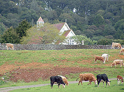
St. Michael's Anglican Church was built on the site of Pene Taui's Pā
Pa
-Places:* Pâ, a town in Burkina Faso* Pâ Department, a department in Burkina Faso* PA postcode area, in Scotland* Province of Palermo, Italy* Palo Alto, California* Panama, ISO country code** .pa, the country code top level domain for Panama...
. During the Battle of Ohaeawai
Battle of Ohaeawai
The Battle of Ohaeawai was fought between British forces and local Māori during the Flagstaff War in July 1845 at Ohaeawai in the North Island of New Zealand...
the pā was fortified by Te Ruki Kawiti; the outcome of the battle is considered to be a defeat of the British colonial forces. St. Michael's Anglican Church is 5 miles (8 km) from Kaikohe
Kaikohe
Kaikohe is the central service area for the Far North District of New Zealand, about 260 km from Auckland, situated on State Highway 12 at...
and 2 miles (3.2 km) from the township of Ohaeawai; it stands on a gentle rise a short distance west of the main road. The locality is usually called Ngawha
Ngawha Springs
Ngawha Springs is a small settlement approximately five kilometres east of the town of Kaikohe, Northland in New Zealand.It is the location of Ngawha Springs, a hot water spring that reputedly has therapeutic properties for those who bathe in its waters, and is the source of the steam used at the...
, from the hot springs in the neighbourhood. Cowan (1922) asserts that the site of the church (and earlier pā) is the true Ohaeawai; the European township which has appropriated the name should properly be known as Taiamai.
The 2006 New Zealand Census of Population and Dwellings
New Zealand Census of Population and Dwellings
The New Zealand government department Statistics New Zealand conducts a census of population and dwellings every five years. The census scheduled for 2011 was cancelled due to circumstances surrounding the February 2011 Christchurch earthquake, however, and legislation introduced to hold the next...
recorded Ohaeawai's population as 711, a decrease of 15 people since the 2001 census.
Education
Ohaeawai School is a coeducational contributing primary (years 1-6) school with a decile ratingSocio-Economic Decile
Decile, Socio-Economic Decile or Socio-Economic Decile Band is a widely used measure in education in New Zealand used to target funding and support to more needy schools....
of 2 and a roll of 119.