

Salar de Atacama
Encyclopedia
Chile
Chile ,officially the Republic of Chile , is a country in South America occupying a long, narrow coastal strip between the Andes mountains to the east and the Pacific Ocean to the west. It borders Peru to the north, Bolivia to the northeast, Argentina to the east, and the Drake Passage in the far...
. It is located 55 km (34.2 mi) south of San Pedro de Atacama
San Pedro de Atacama
San Pedro de Atacama is a Chilean town and commune in El Loa Province, Antofagasta Region. It is located east of Antofagasta, some 106 km southeast of Calama and the Chuquicamata copper mine, overlooking the Licancabur volcano. It features a significant archeological museum, the R. P...
, is surrounded by mountains and has no drainage outlets. To the east is enclosed by the main chain of the Andes
Andes
The Andes is the world's longest continental mountain range. It is a continual range of highlands along the western coast of South America. This range is about long, about to wide , and of an average height of about .Along its length, the Andes is split into several ranges, which are separated...
, while to the west lies a secondary mountain range of the Andes called Cordillera de Domeyko. Large volcanoes dominate the landscape, including the Licancabur
Licancabur
Licancabur is a highly symmetrical stratovolcano on the southernmost part of the border between Chile and Bolivia. It is located just southwest of Laguna Verde in Bolivia. The volcano dominates the landscape of the Salar de Atacama area...
, Acamarachi
Acamarachi
Acamarachi, also known as Pili, is a stratovolcano located northeast of the volcanoes Aguas Calientes and Lascar, and southwest of the sector Salar de Pujsa of Los Flamencos National Reserve, in the Antofagasta Region of Chile. The volcano lies on a high plateau called Puna de Atacama.It has a...
, Aguas Calientes
Aguas Calientes (volcano)
Aguas Calientes Volcano or Cerro Aguas Calientes, also called Simbad, is a cone-shaped stratovolcano located east of the Lascar volcano and directly north of Laguna Lejía, in Chile's II Region...
and the Láscar. The latter is one of the most active volcanoes in Chile. All of them are located along the eastern side of the Salar de Atacama, forming a generally north-south trending line of volcanoes that separate it from smaller endorheic basins.
Features
The salt flat encompasses 3,000 km² (1,864.11 mi²), is about 100 km (62.14 mi) long and 80 km (49.71 mi) wide, which makes it AmericasAmericas
The Americas, or America , are lands in the Western hemisphere, also known as the New World. In English, the plural form the Americas is often used to refer to the landmasses of North America and South America with their associated islands and regions, while the singular form America is primarily...
' second largest and is also the second in the world, after Salar de Uyuni
Salar de Uyuni
Salar de Uyuni is the world's largest salt flat at . It is located in the Potosí and Oruro departments in southwest Bolivia, near the crest of the Andes, and is elevated above the mean sea level. The Salar was formed as a result of transformations between several prehistoric lakes...
in Bolivia
Bolivia
Bolivia officially known as Plurinational State of Bolivia , is a landlocked country in central South America. It is the poorest country in South America...
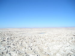
(10,582 km²). Its average elevation is about 2,300 m asl. The topography of the core portion of the salar exhibits a high level of roughness, which is due to that the surface of this area is permanently free of water, unlike the most of the other salt flats, as for example the Salar de Uyuni, which is periodically covered with shallow water.
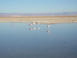
Some areas of the salt flat form part of Los Flamencos National Reserve
Los Flamencos National Reserve
Los Flamencos National Reserve is a nature reserve located in the commune of San Pedro de Atacama, Antofagasta Region of Chile. The reserve covers a total area of in the Central Andean dry puna ecoregion and consists of seven separate sectors....
. The Lagunas Cejar is a sink hole lake in the Salar de Atacama, 18 km from San Pedro, Chile. It has a 40% concentration of salt, producing an effect of floating like the Dead Sea
Dead Sea
The Dead Sea , also called the Salt Sea, is a salt lake bordering Jordan to the east and Israel and the West Bank to the west. Its surface and shores are below sea level, the lowest elevation on the Earth's surface. The Dead Sea is deep, the deepest hypersaline lake in the world...
.
Lithium production
The Salar of Atacama is the world's largest and purest active source of lithiumLithium
Lithium is a soft, silver-white metal that belongs to the alkali metal group of chemical elements. It is represented by the symbol Li, and it has the atomic number 3. Under standard conditions it is the lightest metal and the least dense solid element. Like all alkali metals, lithium is highly...
, contains 27 percent of the world's lithium reserve base, and as of 2008 provided almost 30 percent of the world's lithium carbonate
Lithium carbonate
Lithium carbonate is a chemical compound of lithium, carbon, and oxygen with the formula Li2CO3. This colorless salt is widely used in the processing of metal oxides and has received attention for its use in psychiatry. It is found in nature as the rare mineral zabuyelite.-Properties:Like almost...
supply, followed by China
People's Republic of China
China , officially the People's Republic of China , is the most populous country in the world, with over 1.3 billion citizens. Located in East Asia, the country covers approximately 9.6 million square kilometres...
with 23 percent. Thanks to its brine's high lithium concentration, averaging 2,700 parts per million, its high rate of evaporation, 3,500 millimeters per year, and its low annual rainfall of just a few millimeters per year, Atacama's finished lithium carbonate is easier to produce and cheaper than the one that could be produced from the neighboring Salar de Uyuni, which is estimated to have half of the lithium reserves in the world. Atacama's has the highest rate of evaporation in the lithium industry, followed by Puna de Atacama
Puna de Atacama
The Puna de Atacama or Atacama Plateau is an arid high plateau averaging about above sea level and spanning an area of , in the Andes of northern Chile and Argentina and southwest Bolivia. Before the War of the Pacific , the region belonged to Bolivia. In 1898 it was ceded to Argentina in...
, Argentina
Argentina
Argentina , officially the Argentine Republic , is the second largest country in South America by land area, after Brazil. It is constituted as a federation of 23 provinces and an autonomous city, Buenos Aires...
, with 2,600 mm per year, and the Salar de Uyuni
Salar de Uyuni
Salar de Uyuni is the world's largest salt flat at . It is located in the Potosí and Oruro departments in southwest Bolivia, near the crest of the Andes, and is elevated above the mean sea level. The Salar was formed as a result of transformations between several prehistoric lakes...
, Bolivia
Bolivia
Bolivia officially known as Plurinational State of Bolivia , is a landlocked country in central South America. It is the poorest country in South America...
, with a rate of 1,300 to 1,700 mm per year.