
New Zealand State Highway 2
Encyclopedia
State Highway 2 is one of New Zealand
's eight national highways
. With the exception of State Highway 1
, which runs the length of both of the country's main islands, SH 2 is the longest highway in the North Island
. The highway runs north-south via the country's east coast, connecting Auckland and Wellington via the Hawkes Bay cities of Napier
and Hastings
, Gisborne
and the Bay of Plenty
including Tauranga
.
For most of its length SH 2 is a two-lane single carriageway, with at-grade intersections and property accesses, both in rural and urban areas.
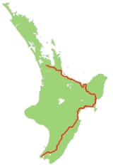
 This is the route that SH 2 takes in 2008.
The highway deviates from SH 1 just north of Pokeno
, some 49 km south of central Auckland
. It initially heads east, crossing the Hauraki Plains
before running the length of the Karangahake Gorge
, a break in the hills between the Coromandel Peninsula
and Kaimai Ranges
. From the mining town of Waihi
it runs southeast, skirting the edge of Tauranga Harbour
, which it crosses on the Tauranga Harbour Bridge
. The highway continues to follow the coast for a further 60 km, until it reaches the village of Matata
.
From Matata the highway heads slightly inland, crossing through the Rangitaiki plain to the south of Whakatane
, loops south to Taneatua
, through the Waimana gorge then back north to briefly return to the coast near Opotiki
. After Opotiki the highway turns inland, ascending southeast along the valley of the Waioeka River
, and from there winding up to the 725-metre Traffords Hill Summit. From here it descends into the watershed of the Waipaoa River
following that river's valley from Te Karaka
to Makaraka
, just outside Gisborne
, to which it is connected by a short stretch of SH 35.
From this point the highway turns south , passing the Wharerata Forest and the isthmus of the Mahia Peninsula
, before turning west to follow the coast of Hawke Bay
. Close to the mouth of the Waihua River
the highway heads briefly inland, passing the Mohaka Forest and Lake Tutira
before rejoining the coast not far from the junction with SH 5 at Bay View
. The highway continues south to the twin bay cities, crossing Napier
and turning inland to enter Hastings
. From central Hastings, the highway briefly loses its national highway status for seven kilometres, regaining that status at Pakipaki.
The highway continues to head inland from Pakipaki, initially southwest to Waipukurau
, then briefly west to follow tributaries of the Tukituki River
upstream. Close to Norsewood
the highway again turns southwest, a direction it maintains for much of the remainder of its journey, crossing undulating country that forms the upper catchment of the Manawatu River
. In Woodville
, the highway meets SH 3, which links SH 2 with the city of Palmerston North
via the Manawatu Gorge
. SH2 continues south into the Wairarapa
, travelling through the town of Eketahuna
and into the town of Masterton
.
The last 100 kilometres of highway takes it through several small Wairarapa towns (Carterton
, Greytown
, and Featherston
), and then via a winding and steep section over the Rimutaka Range
(summit 555 metres) into the Hutt Valley
. The highway travels along the edge of Upper Hutt
, Lower Hutt
and Petone
before skirting the upper part of Wellington Harbour before terminating at the junction with SH 1 at the Ngauranga Interchange
, five kilometres of central Wellington.
Although the Ngauranga Interchange is the official end of State Highway 2, it is signed northbound as far back as the Mount Victoria Tunnel, 8 km before it begins.
to SH 50 at Taradale. This forms the northern part of the Hawke's Bay Expressway.
to Te Maunga. This was changed in 2009 when a second harbour bridge opened next to the current one, providing 4 lanes of traffic and an overpass from the harbour bridges to the existing Takatimu Drive expressway
State Highway 2 used to extend into Whakatane, but recently this section was moved inland to pass through Edgecumbe and Awakeri, with State Highway 30 extended to Whakatane to cover the former route occupied by State Highway 2.
State Highway 2 used to run between Hastings and Pakipaki, but recently has been revoked.
State Highway 2's southern terminus has also changed. It used to form the southern part of the Wellington Urban Motorway
when State Highway 1 finished at the Aotea Quay off-ramp. In 1996, State Highway 1 replaced this section.
At Mangatawhiri the section of State Highway 2 had a poor crash record. A seven-kilometre Mangatawhiri Deviation was built to improve safety by bypassing a section. East and west bound passing lanes provide safe passing opportunities. Grade separated intersections improved safety for traffic wanting to cross or join the highway in December 2008.
The Rimutaka Hill Road, transversing the Rimutaka Ranges between Featherston and Upper Hutt, also has had a poor crash record, with many tight 25 and 35km/h corners, and a lack of safety barriers to prevent vehicles dropping down off the road. The original winding route between Kaitoke and Te Marua was significantly realigned between 2002 and 2006. The tightest and narrowest corner on the road, named Muldoon's Corner after the former Prime Minister's financial stance ("tight and to the right"), was bypassed with a new wider 55km/h corner in June 2011.
River Road, between Maoribank and Silverstream in Upper Hutt, was opened in 1987 to bypass central Upper Hutt. The new route was a two-laned single carriageway 100km/h road on the Hutt River's banks, crossing the river at Moonshine, and replaced the 50km/h route via Fergusson Drive. Since then, sections of the road have been widended to three lanes and had median barriers installed.
New Zealand
New Zealand is an island country in the south-western Pacific Ocean comprising two main landmasses and numerous smaller islands. The country is situated some east of Australia across the Tasman Sea, and roughly south of the Pacific island nations of New Caledonia, Fiji, and Tonga...
's eight national highways
New Zealand State Highway network
The New Zealand State Highway network is the major national highway network in New Zealand. Just under 100 roads in both the North and South Islands are State Highways...
. With the exception of State Highway 1
State Highway 1 (New Zealand)
State Highway 1 is the longest and most significant road in the New Zealand roading network, running the length of both main islands. It appears on road maps as SH 1 and on road signs as a white number 1 on a red shield, but it has the official designations SH 1N in the North Island, SH 1S in the...
, which runs the length of both of the country's main islands, SH 2 is the longest highway in the North Island
North Island
The North Island is one of the two main islands of New Zealand, separated from the much less populous South Island by Cook Strait. The island is in area, making it the world's 14th-largest island...
. The highway runs north-south via the country's east coast, connecting Auckland and Wellington via the Hawkes Bay cities of Napier
Napier, New Zealand
Napier is a New Zealand city with a seaport, located in Hawke's Bay on the eastern coast of the North Island. The population of Napier is about About 18 kilometres south of Napier is the inland city of Hastings. These two neighboring cities are often called "The Twin Cities" or "The Bay Cities"...
and Hastings
Hastings, New Zealand
The city of Hastings is a major urban settlement in the Hawke's Bay region of the North Island of New Zealand, and it is the largest settlement by population in Hawke's Bay. Hastings city is the administrative centre of the Hastings District...
, Gisborne
Gisborne, New Zealand
-Economy:The harbour was host to many ships in the past and had developed as a river port to provide a more secure location for shipping compared with the open roadstead of Poverty Bay which can be exposed to southerly swells. A meat works was sited beside the harbour and meat and wool was shipped...
and the Bay of Plenty
Bay of Plenty
The Bay of Plenty , often abbreviated to BOP, is a region in the North Island of New Zealand situated around the body of water of the same name...
including Tauranga
Tauranga
Tauranga is the most populous city in the Bay of Plenty region, in the North Island of New Zealand.It was settled by Europeans in the early 19th century and was constituted as a city in 1963...
.
For most of its length SH 2 is a two-lane single carriageway, with at-grade intersections and property accesses, both in rural and urban areas.
Route
The highway deviates from SH 1 just north of Pokeno
Pokeno
Pokeno is a small town in New Zealand, located 50 kilometres southeast of Auckland. State Highway 1 originally ran through the town, but the upgrading of the highway in 1992 to expressway standards mean that the town has been bypassed....
, some 49 km south of central Auckland
Auckland
The Auckland metropolitan area , in the North Island of New Zealand, is the largest and most populous urban area in the country with residents, percent of the country's population. Auckland also has the largest Polynesian population of any city in the world...
. It initially heads east, crossing the Hauraki Plains
Hauraki Plains
The Hauraki Plains are a geographical feature and non-administrative area located in the northern North Island of New Zealand, at the lower end of the Thames Valley...
before running the length of the Karangahake Gorge
Karangahake Gorge
The Karangahake Gorge lies between the Coromandel and Kaimai ranges, at the southern end of the Coromandel Peninsula in New Zealand's North Island. A sharply winding canyon, it was formed by the Ohinemuri River. State Highway 2 passes through this gorge between the towns of Paeroa, Waikino and Waihi...
, a break in the hills between the Coromandel Peninsula
Coromandel Peninsula
The Coromandel Peninsula lies in the North Island of New Zealand. It is part of the Waikato Region and Thames-Coromandel District and extends 85 kilometres north from the western end of the Bay of Plenty, forming a natural barrier to protect the Hauraki Gulf and the Firth of Thames in the west...
and Kaimai Ranges
Kaimai Ranges
The Kaimai Range is a mountain range in the North Island of New Zealand. It is part of a series of ranges, with the Coromandel Range to the north and the Mamaku Ranges to the south. The Kaimai Range separates the Waikato in the west from the Bay of Plenty in the east.The highest point of the range...
. From the mining town of Waihi
Waihi
Waihi is a town in Hauraki District in the North Island of New Zealand, especially notable for its history as a gold mine town. It had a population of 4,503 at the 2006 census....
it runs southeast, skirting the edge of Tauranga Harbour
Tauranga Harbour
The Tauranga Harbour is the natural tidal harbour that surrounds Tauranga CBD and the Mount Maunganui area of Tauranga, New Zealand which flows into the Pacific Ocean at Mount Maunganui and Bowentown. The harbour is effectively two flooded river systems separated from the Pacific Ocean, by the...
, which it crosses on the Tauranga Harbour Bridge
Tauranga Harbour Bridge
The Tauranga Harbour Bridge refers to two bridges that carry Te Awanui Drive over the Tauranga Harbour. Te Awanui Drive is part of an expressway that connects Tauranga to Mount Maunganui. On the Tauranga side, Te Awanui Drive connects to Takitimu Drive, which crosses the Chapel Street Viaduct...
. The highway continues to follow the coast for a further 60 km, until it reaches the village of Matata
Matata
Matata can be:*Matata, a religious figure in Georgia *Matata, a town in New Zealand.*Matata, a New Zealand bird.*Matata, a bonobo.*J.C. Matata, a hip hop musician.*The latter part of the phrase hakuna matata....
.
From Matata the highway heads slightly inland, crossing through the Rangitaiki plain to the south of Whakatane
Whakatane
Whakatane is a town in the eastern Bay of Plenty Region, in the North Island of New Zealand, and is the seat of the Bay of Plenty Regional Council. Whakatane is 90 km east of Tauranga and 89 km north-east of Rotorua, at the mouth of the Whakatane River.The town has a population of , with...
, loops south to Taneatua
Taneatua
Taneatua is a small town in the Bay of Plenty region of New Zealand's North Island. It is officially defined as a "populated area less than a town". The 2001 New Zealand Census of Population and Dwellings found its population to be 750, a 14.7% decline since the previous census in 1996...
, through the Waimana gorge then back north to briefly return to the coast near Opotiki
Opotiki
Opotiki is a town in the eastern Bay of Plenty in the North Island of New Zealand. It houses the headquarters of the Opotiki District Council and comes under the Bay of Plenty Regional Council.-Population:* of the town: 4176 - Male 1,989, Female 2,187...
. After Opotiki the highway turns inland, ascending southeast along the valley of the Waioeka River
Waioeka River
The Waioeka River is found in the north of New Zealand's North Island. It flows north for 65 kilometres from Te Urewera National Park to reach the sea at Opotiki. It shares its estuary with the Otara River.-History:...
, and from there winding up to the 725-metre Traffords Hill Summit. From here it descends into the watershed of the Waipaoa River
Waipaoa River
The Waipaoa River is a river of the northeast of New Zealand's North Island. It rises on the eastern slopes of the Raukumara Range, flowing south for 80 kilometres to reach Poverty Bay and the Pacific Ocean just south of Gisborne. For about half of this distance its valley is followed by State...
following that river's valley from Te Karaka
Te Karaka
Te Karaka is a small settlement inland from Gisborne, in the northeast of New Zealand's North Island. It is located in the valley of the Waipaoa River close to its junction with its tributary, the Waihora River...
to Makaraka
Makaraka
Makaraka are an ethnic group indigenous to Central Africa, closely related to the powerful Azande or NiamNiain, occupying the Bahr-el-Ghazal west of Lado. They came originally from the country of the Kibas, north of the Welle. They do not extract the incisors...
, just outside Gisborne
Gisborne, New Zealand
-Economy:The harbour was host to many ships in the past and had developed as a river port to provide a more secure location for shipping compared with the open roadstead of Poverty Bay which can be exposed to southerly swells. A meat works was sited beside the harbour and meat and wool was shipped...
, to which it is connected by a short stretch of SH 35.
From this point the highway turns south , passing the Wharerata Forest and the isthmus of the Mahia Peninsula
Mahia Peninsula
The Mahia Peninsula is located on the east coast of New Zealand's North Island, between the cities of Napier and Gisborne.-Geography:The peninsula is long and wide rising to its highest point at Rahuimokairoa reaching about above sea level. Mahia was initially an island which over time, has had...
, before turning west to follow the coast of Hawke Bay
Hawke Bay
Hawke Bay is a large bay on the eastern coast of the North Island of New Zealand. It stretches from the Mahia Peninsula in the northeast to Cape Kidnappers in the southwest, a distance of some 100 kilometres....
. Close to the mouth of the Waihua River
Waihua River
The Waihua River is a river of the northern Hawke's Bay Region of New Zealand's North Island. Its course roughly parallels that of its northern neighbour, the Waiau River. The Waihua rises in rough hill country north of Raupunga, flowing initially east before turning southeast to reach Hawke Bay 15...
the highway heads briefly inland, passing the Mohaka Forest and Lake Tutira
Lake Tutira
Lake Tutira is a body of water in northeastern Hawke's Bay, New Zealand.Much of the area was surveyed by Herbert Guthrie-Smith, who farmed 60,000 acres surrounding the lake. Guthrie-Smith, a naturalist, published Tutira: the story of a New Zealand sheep station in 1921...
before rejoining the coast not far from the junction with SH 5 at Bay View
Bay View, New Zealand
Bay View is a settlement in the Hawke's Bay Region of the eastern North Island of New Zealand. It lies on State Highway 2 nine kilometres north of the centre of Napier. The area was previously known as Petane and was seized by Maori in the early 1860's with the idea of attacking Napier.-References:...
. The highway continues south to the twin bay cities, crossing Napier
Napier, New Zealand
Napier is a New Zealand city with a seaport, located in Hawke's Bay on the eastern coast of the North Island. The population of Napier is about About 18 kilometres south of Napier is the inland city of Hastings. These two neighboring cities are often called "The Twin Cities" or "The Bay Cities"...
and turning inland to enter Hastings
Hastings, New Zealand
The city of Hastings is a major urban settlement in the Hawke's Bay region of the North Island of New Zealand, and it is the largest settlement by population in Hawke's Bay. Hastings city is the administrative centre of the Hastings District...
. From central Hastings, the highway briefly loses its national highway status for seven kilometres, regaining that status at Pakipaki.
The highway continues to head inland from Pakipaki, initially southwest to Waipukurau
Waipukurau
Waipukurau , also known as Ypuk, is the largest town in the Central Hawke's Bay District on the east coast of the North Island of New Zealand. It is located 50 kilometres southwest of Hastings on the banks of the Tukituki River....
, then briefly west to follow tributaries of the Tukituki River
Tukituki River
The Tukituki River is found in the eastern North Island of New Zealand. It flows from the Ruahine Ranges to the Pacific Ocean at the southern end of Hawke's Bay....
upstream. Close to Norsewood
Norsewood
Norsewood is a small rural town in the Manawatu - Wanganui region of New Zealand's North Island. It is situated in the Tararua District. Its population is 330....
the highway again turns southwest, a direction it maintains for much of the remainder of its journey, crossing undulating country that forms the upper catchment of the Manawatu River
Manawatu River
The Manawatu River is a major river of the southern North Island of New Zealand.The river has its headwaters to the northwest of Norsewood in the Ruahine Ranges of southern Hawke's Bay. It flows initially eastward before turning south-west near Ormondville, flowing 40 km before turning...
. In Woodville
Woodville, New Zealand
Woodville is a small town in the southern North Island of New Zealand, 75 km north of Masterton and 25 km east of Palmerston North. In the 2006 census 1,398 people are usually resident in Woodville, a decrease of 81 people, or 5.5%, since the 2001 Census.-Early History and Local...
, the highway meets SH 3, which links SH 2 with the city of Palmerston North
Palmerston North
Palmerston North is the main city of the Manawatu-Wanganui region of the North Island of New Zealand. It is an inland city with a population of and is the country's seventh largest city and eighth largest urban area. Palmerston North is located in the eastern Manawatu Plains near the north bank...
via the Manawatu Gorge
Manawatu Gorge
The Manawatu Gorge runs between the Ruahine and Tararua Ranges of the North Island of New Zealand, linking the Manawatu and Hawke's Bay regions...
. SH2 continues south into the Wairarapa
Wairarapa
Wairarapa is a geographical region of New Zealand. It occupies the south-eastern corner of the North Island, east of metropolitan Wellington and south-west of the Hawke's Bay region. It is lightly populated, having several rural service towns, with Masterton being the largest...
, travelling through the town of Eketahuna
Eketahuna
Eketahuna is a small rural service town, the most southerly in the Tararua District in the Manawatu-Wanganui region of the North Island of New Zealand, but is considered to be in northern Wairarapa. It was called Mellenskov, but was renamed soon after its founding.The town is located at the foot of...
and into the town of Masterton
Masterton
Masterton is a large town and local government district in the Wellington Region of New Zealand. It is the largest town in the Wairarapa, a region separated from Wellington by the Rimutaka ranges...
.
The last 100 kilometres of highway takes it through several small Wairarapa towns (Carterton
Carterton, New Zealand
Carterton is a small town in the Wellington Region of New Zealand and the seat of the Carterton District. It lies in a farming area of the Wairarapa in New Zealand's North Island. It is located southwest of Masterton and northeast of Wellington...
, Greytown
Greytown, New Zealand
Greytown or Te Hupenui, population 2,001 , is a town in the Wellington region of New Zealand. It lies in the Wairarapa, in the lower North Island...
, and Featherston
Featherston, New Zealand
Featherston is a town in the north of the Wellington Region region of New Zealand. It lies in the Wairarapa, just north of the Rimutaka Tunnel, in the South Wairarapa District. The population was 2,340 in the 2006 Census....
), and then via a winding and steep section over the Rimutaka Range
Rimutaka Range
The Rimutaka Range is one of several mountain ranges in the North Island of New Zealand which form a ridge running parallel with the east coast of the island between East Cape and Wellington.The ridge is at its most pronounced in the southern part of the island, where it consists of the Ruahine,...
(summit 555 metres) into the Hutt Valley
Hutt Valley, New Zealand
The Hutt Valley is the large area of fairly flat land in the Hutt River valley in the Wellington region of New Zealand. Like the river that flows through it, it takes its name from Sir William Hutt, a director of the New Zealand Company in early colonial New Zealand.The river flows roughly along...
. The highway travels along the edge of Upper Hutt
Upper Hutt
Upper Hutt is a satellite city of Wellington. It is New Zealand's smallest city by population, the second largest by land area. It is in Greater Wellington.-Geography:Upper Hutt is 30 km north-east of Wellington...
, Lower Hutt
Lower Hutt
Lower Hutt is a city in the Wellington region of New Zealand. Its council has adopted the name Hutt City Council, but neither the New Zealand Geographic Board nor the Local Government Act recognise the name Hutt City. This alternative name can lead to confusion, as there are two cities in the...
and Petone
Petone
Petone is a major suburb of the city of Lower Hutt in New Zealand. It is located at the southern end of the narrow triangular plain of the Hutt River, on the northern shore of Wellington Harbour...
before skirting the upper part of Wellington Harbour before terminating at the junction with SH 1 at the Ngauranga Interchange
Ngauranga Interchange
The Ngauranga Interchange is a major interchange in the suburb of Ngauranga, in Wellington City, New Zealand. The Ngauranga interchange connects State Highways 1 and 2 with each other, and also allows traffic to connect to Hutt Road, for access to the interisland ferry terminals...
, five kilometres of central Wellington.
Although the Ngauranga Interchange is the official end of State Highway 2, it is signed northbound as far back as the Mount Victoria Tunnel, 8 km before it begins.
Spur sections
State Highway 2 has two short spurs: State Highway 2A and State Highway 2B. State Highway 2A runs for 3.8 km from SH2 through Tauranga as 15th Avenue and Turret Road to the junction with SH29 at Maungatapu. State Highway 2B runs for 4.1 km from SH 2 at Napier AirportNapier Airport
Hawke's Bay Airport is Hawke's Bay's main commercial airport serving domestic flights to the main centres of Auckland, Wellington and Christchurch as well as smaller centres such as Gisborne, Tauranga, Hamilton and Palmerston North...
to SH 50 at Taradale. This forms the northern part of the Hawke's Bay Expressway.
History
Stage Highway 2 used to travel where State Highway 2A travels today in Tauranga, along 15th Ave, into Turret Road, and across the harbour to Maungatapu, where it joined to State Highway 29, and then headed across the Maungatapu BridgeMaungatapu Bridge
The Maungatapu Bridge is a beam bridge which crosses the Tauranga Harbour and connects the Matapihi and Maungatapu peninsulas in New Zealand. The bridge opened in 1959 and is 316 metres long and 10 metres wide. The bridge carries two lanes of traffic and a footpath. Prior to 2009 State Highway 2...
to Te Maunga. This was changed in 2009 when a second harbour bridge opened next to the current one, providing 4 lanes of traffic and an overpass from the harbour bridges to the existing Takatimu Drive expressway
State Highway 2 used to extend into Whakatane, but recently this section was moved inland to pass through Edgecumbe and Awakeri, with State Highway 30 extended to Whakatane to cover the former route occupied by State Highway 2.
State Highway 2 used to run between Hastings and Pakipaki, but recently has been revoked.
State Highway 2's southern terminus has also changed. It used to form the southern part of the Wellington Urban Motorway
Wellington Urban Motorway
The Wellington Urban Motorway, part of SH 1, is the major road into and out of Wellington, New Zealand. It is 7 km long, ranges from three to six lanes wide, and extends from the base of the Ngauranga Gorge into the Wellington CBD....
when State Highway 1 finished at the Aotea Quay off-ramp. In 1996, State Highway 1 replaced this section.
At Mangatawhiri the section of State Highway 2 had a poor crash record. A seven-kilometre Mangatawhiri Deviation was built to improve safety by bypassing a section. East and west bound passing lanes provide safe passing opportunities. Grade separated intersections improved safety for traffic wanting to cross or join the highway in December 2008.
The Rimutaka Hill Road, transversing the Rimutaka Ranges between Featherston and Upper Hutt, also has had a poor crash record, with many tight 25 and 35km/h corners, and a lack of safety barriers to prevent vehicles dropping down off the road. The original winding route between Kaitoke and Te Marua was significantly realigned between 2002 and 2006. The tightest and narrowest corner on the road, named Muldoon's Corner after the former Prime Minister's financial stance ("tight and to the right"), was bypassed with a new wider 55km/h corner in June 2011.
River Road, between Maoribank and Silverstream in Upper Hutt, was opened in 1987 to bypass central Upper Hutt. The new route was a two-laned single carriageway 100km/h road on the Hutt River's banks, crossing the river at Moonshine, and replaced the 50km/h route via Fergusson Drive. Since then, sections of the road have been widended to three lanes and had median barriers installed.
Future
Currently there are several projects to improve stafety of State Highway 2. They include:- Kopuku Realignment: this section of highway is under investigation to improve to 4 lane highway between the Mangatawhiri and Maramarua Deviations. The project is primarily a realignment project aimed at improving road safety and providing passing opportunities.
- Maramarua Deviation: a bypass of Maramarua township on SH2, east of the SH1/2 Pokeno turnoff, to improve road safety, provide passing opportunities and reduce holiday peak congestion in Maramarua township. Expected completion of the project detail design will be completed by end 2008/ start of 2009.
- Katikati Bypass: an investigation is currently being unertaken into the long-standing designation for the bypass to ensure that it will meet the future needs of Katikati, and is consistent with Transit's overall strategy for long-term management of SH2.
- Tauranga Eastern MotorwayTauranga Eastern MotorwayThe Tauranga Eastern Motorway, now known as Tauranga Eastern Link is a proposed motorway in the Bay of Plenty region in New Zealand that will replace a section of State Highway 2. It will cover 23 km from Te Maunga junction to Paengaroa, and will improve access from the east and south from...
: a proposed Motorway in the Bay of Plenty region. It will replace a section of State Highway 2, covering almost 23 km from Te Maunga junction to Paengaroa, and will improve access from the east (Te PukeTe PukeTe Puke is a town located 28 kilometres southeast of Tauranga in the Western Bay of Plenty region of New Zealand. It is particularly famous for the cultivation of kiwifruit...
, WhakataneWhakataneWhakatane is a town in the eastern Bay of Plenty Region, in the North Island of New Zealand, and is the seat of the Bay of Plenty Regional Council. Whakatane is 90 km east of Tauranga and 89 km north-east of Rotorua, at the mouth of the Whakatane River.The town has a population of , with...
, OpotikiOpotikiOpotiki is a town in the eastern Bay of Plenty in the North Island of New Zealand. It houses the headquarters of the Opotiki District Council and comes under the Bay of Plenty Regional Council.-Population:* of the town: 4176 - Male 1,989, Female 2,187...
, Gisborne) and south from RotoruaRotoruaRotorua is a city on the southern shores of the lake of the same name, in the Bay of Plenty region of the North Island of New Zealand. The city is the seat of the Rotorua District, a territorial authority encompassing the city and several other nearby towns...
and TaupoTaupoTaupo is a town on the shore of Lake Taupo in the centre of the North Island of New Zealand. It is the seat of the Taupo District Council and lies in the southern Waikato Region....
. It is the main route for trucks heading to the Port of TaurangaPort of TaurangaPort of Tauranga is the port of Tauranga, New Zealand, the largest port in the country in terms of total cargo volume, and the second largest in terms of container throughput. with Port of Tauranga Ltd being the company operating it...
from Rotorua and the eastern Bay of PlentyBay of PlentyThe Bay of Plenty , often abbreviated to BOP, is a region in the North Island of New Zealand situated around the body of water of the same name...
, and connects the economically important central plateau forestry industry with the port for export.
- Dowse to PetonePetonePetone is a major suburb of the city of Lower Hutt in New Zealand. It is located at the southern end of the narrow triangular plain of the Hutt River, on the northern shore of Wellington Harbour...
Upgrade Project: A grade-separated interchange with raised roundabout over SH2 at Dowse Drive with a connection to Hutt Road and Dowse Drive; an overbridge to replace the traffic lights at Korokoro connecting Petone and Korokoro; upgrading the section of SH2 between Korokoro and the Petone overbridges in the short term by providing a raised central curbed median to separate north and southbound lanes. It is expected to be completed by 2010.
Traffic
The busiest section of State Highway 2 exists just north of the Ngauranga Interchange in Wellington, which was measured at km 977.6 to have an AADT of 67,000 vehicles. The quietest section of road is nead Otoko in the Gisborne District, which was measured at km 389.5 to have an AADT of just 1000 vehicles.Major intersections
| Territorial authority | Location | km | Destinations | Notes |
|---|---|---|---|---|
| Franklin District Franklin District The territorial authority of Franklin District was abolished on 31 October 2010 and was divided between Auckland Council in the Auckland Region to the north and Waikato and Hauraki districts in the Waikato Region to the south and east. It was administered from the town of Pukekohe... |
Pokeno Pokeno Pokeno is a small town in New Zealand, located 50 kilometres southeast of Auckland. State Highway 1 originally ran through the town, but the upgrading of the highway in 1992 to expressway standards mean that the town has been bypassed.... |
0 |  SH 1 north SH 1 north (Waikato Expressway Waikato Expressway The Waikato Expressway is a dual carriageway section of State Highway 1 in the Waikato region of the North Island of New Zealand and forms part of the link between Auckland and Hamilton... ) Auckland Auckland The Auckland metropolitan area , in the North Island of New Zealand, is the largest and most populous urban area in the country with residents, percent of the country's population. Auckland also has the largest Polynesian population of any city in the world... |
SH 2 begins |
| SH 1 south (Waikato Expressway Waikato Expressway The Waikato Expressway is a dual carriageway section of State Highway 1 in the Waikato region of the North Island of New Zealand and forms part of the link between Auckland and Hamilton... ) Hamilton Hamilton, New Zealand Hamilton is the centre of New Zealand's fourth largest urban area, and Hamilton City is the country's fourth largest territorial authority. Hamilton is in the Waikato Region of the North Island, approximately south of Auckland... |
||||
| Waikato District Waikato District Waikato District is a territorial authority of New Zealand, in the northern part of Waikato Region, North Island. Waikato District is administered by the Waikato District Council, with headquarters in Ngaruawahia.... |
District contains no major junctions | |||
| Hauraki District Hauraki District The Hauraki District Council is a municipality in the Waikato Region of New Zealand. The seat of the council is at Paeroa.The area covered by the district extends from the southwest corner of the Firth of Thames southeast towards Te Aroha, although that town lies beyond its boundaries... |
Mangatarata | 34 |  SH 25 SH 25 Thames Thames, New Zealand Thames is a town at the southwestern end of the Coromandel Peninsula in New Zealand's North Island. It is located on the Firth of Thames close to the mouth of the Waihou River. The town is the seat of the Thames-Coromandel District Council.... , Coromandel Peninsula Coromandel Peninsula The Coromandel Peninsula lies in the North Island of New Zealand. It is part of the Waikato Region and Thames-Coromandel District and extends 85 kilometres north from the western end of the Bay of Plenty, forming a natural barrier to protect the Hauraki Gulf and the Firth of Thames in the west... |
|
| 37 |  SH 27 SH 27 Matamata Matamata Matamata is a rural Waikato town in New Zealand with a population of around 12,000 . It is located near the base of the Kaimai Ranges, and is a thriving farming area known for Thoroughbred horse breeding and training pursuits... , Tirau Tirau Tirau is a small town in the Waikato region of the North Island of New Zealand, 50 kilometres southeast of Hamilton. The town has a population of 732 . Tirau is primarily a farming town but in recent years has begun to exploit the income that comes from being on a major road... |
|||
| Paeroa Paeroa Paeroa is a small town in New Zealand, in the northern Waikato region of the Thames Valley. Located at the foot of the Coromandel Peninsula, it is close to the junction of the Waihou and Ohinemuri Rivers, 20 kilometres from the coast at the Firth of Thames... |
Waihou River Waihou River thumb|The Waihou River near [[Putaruru]]The Waihou River is located in the northern North Island of New Zealand. Its former name, Thames River, was bestowed by Captain James Cook.... |
|||
| 72 |  SH 26 SH 26New Zealand State Highway 26 State Highway 26 is a State Highway in the North Island of New Zealand, linking Hamilton with the Coromandel Peninsula. It starts in the southeastern Hamilton suburb of Hillcrest, and travels 96 kilometres to Kopu, 6 kilometres south of Thames, where it joins with State Highway 25... north (Arney Street) Coromandel Peninsula, Thames |
SH 2/SH 26 concurrency begins | ||
| 73 | SH 26 New Zealand State Highway 26 State Highway 26 is a State Highway in the North Island of New Zealand, linking Hamilton with the Coromandel Peninsula. It starts in the southeastern Hamilton suburb of Hillcrest, and travels 96 kilometres to Kopu, 6 kilometres south of Thames, where it joins with State Highway 25... south (Te Aroha Road) Hamilton |
SH 2/SH 26 concurrency ends | ||
| Waihi Waihi Waihi is a town in Hauraki District in the North Island of New Zealand, especially notable for its history as a gold mine town. It had a population of 4,503 at the 2006 census.... |
93 | SH 25/Pacific Coast Highway Whangamata Whangamata The town of Whangamata is sited on the southeast coast of the Coromandel Peninsula in the North Island of New Zealand. It is located 30 kilometres north of Waihi, to the north of the western extremity of the Bay of Plenty.... , Tairua Tairua The town of Tairua is on the east coast of the Coromandel Peninsula in the North Island of New Zealand. It lies at the mouth of the Tairua River on its north bank and on the small Paku Peninsula. The population was 1,269 in the 2006 Census, a decrease of 192 from 2001... |
SH 2/Pacific Coast Highway concurrency begins | |
| Western Bay of Plenty District Western Bay of Plenty District 200px|rightThe Western Bay of Plenty District Council is a municipality in the Bay of Plenty Region of New Zealand. The seat of the district council is at Greerton in Tauranga City... |
District west of Tauranga contains no major junctions | |||
| Tauranga City Tauranga Tauranga is the most populous city in the Bay of Plenty region, in the North Island of New Zealand.It was settled by Europeans in the early 19th century and was constituted as a city in 1963... |
Cambridge Heights | 149 | Waihi Road Otumoetai Otumoetai Otumoetai is a major suburb of the city of Tauranga in the Bay of Plenty region of New Zealand. Otumoetai is a name used to describe the central area of the peninsula and also the suburbs of Central Otumoetai, Brookfield, Bellevue, Pillans Point, Bureta, Cherrywood and Matua as a... |
|
| Tauranga City | 151 |  SH 2A SH 2A (Tamatea Arikinui Drive) Tauranga South, Greerton , Welcome Bay, Maungatapu |
||
| 153 | Elizabeth St City Centre |
|||
| 154 | Chapel St Otumoetai Otumoetai Otumoetai is a major suburb of the city of Tauranga in the Bay of Plenty region of New Zealand. Otumoetai is a name used to describe the central area of the peninsula and also the suburbs of Central Otumoetai, Brookfield, Bellevue, Pillans Point, Bureta, Cherrywood and Matua as a... City Centre |
Grade Separated Junction | ||
| 155 | Port of Tauranga | Grade Separated Junction | ||
| Mount Maunganui | 157 | Totara St Mount Maunganui Mount Maunganui Mount Maunganui is a town in the Bay of Plenty, New Zealand, located on a peninsula to the north of Tauranga. It was independent from Tauranga until the completion of the Tauranga Harbour Bridge in 1988.... |
||
| 160 | Maunganui Road (North) Mount Maunganui Mount Maunganui Mount Maunganui is a town in the Bay of Plenty, New Zealand, located on a peninsula to the north of Tauranga. It was independent from Tauranga until the completion of the Tauranga Harbour Bridge in 1988.... Omanu Beach |
Also known as the Hewletts Flyover | ||
| Te Maunga | 164 |  SH 29 SH 29Welcome Bay Tauranga South Hamilton, New Zealand Hamilton, New Zealand Hamilton is the centre of New Zealand's fourth largest urban area, and Hamilton City is the country's fourth largest territorial authority. Hamilton is in the Waikato Region of the North Island, approximately south of Auckland... |
||
| Western Bay of Plenty District Western Bay of Plenty District 200px|rightThe Western Bay of Plenty District Council is a municipality in the Bay of Plenty Region of New Zealand. The seat of the district council is at Greerton in Tauranga City... |
Paengaroa | 189 |  SH 33 SH 33 Rotorua Rotorua Rotorua is a city on the southern shores of the lake of the same name, in the Bay of Plenty region of the North Island of New Zealand. The city is the seat of the Rotorua District, a territorial authority encompassing the city and several other nearby towns... |
|
| Whakatane District Whakatane Whakatane is a town in the eastern Bay of Plenty Region, in the North Island of New Zealand, and is the seat of the Bay of Plenty Regional Council. Whakatane is 90 km east of Tauranga and 89 km north-east of Rotorua, at the mouth of the Whakatane River.The town has a population of , with... |
Matata Matata Matata can be:*Matata, a religious figure in Georgia *Matata, a town in New Zealand.*Matata, a New Zealand bird.*Matata, a bonobo.*J.C. Matata, a hip hop musician.*The latter part of the phrase hakuna matata.... |
223 | Pacific Coast Highway (Arawa Street) Whakatane Whakatane Whakatane is a town in the eastern Bay of Plenty Region, in the North Island of New Zealand, and is the seat of the Bay of Plenty Regional Council. Whakatane is 90 km east of Tauranga and 89 km north-east of Rotorua, at the mouth of the Whakatane River.The town has a population of , with... |
|
| Hawkens Junction | 232 |  SH 34 SH 34 (Awaiti South Road) Kawerau, Rotorua Rotorua Rotorua is a city on the southern shores of the lake of the same name, in the Bay of Plenty region of the North Island of New Zealand. The city is the seat of the Rotorua District, a territorial authority encompassing the city and several other nearby towns... |
SH 2/Pacific Coast Highway concurrency ends | |
| Edgecumbe | Rangitaiki River Rangitaiki River The Rangitaiki River is the longest river in the Bay of Plenty region in New Zealand's North Island. It is 155 kilometres in length, and rises inland from northern Hawke Bay to the east of the Kaingaroa Forest.... |
|||
| Awakeri | 242 |  SH 30 SH 30New Zealand State Highway 30 State Highway 30 is a New Zealand State Highway, linking the Waikato and Bay of Plenty towns of Te Kuiti, Mangakino, Rotorua, and Whakatane.... west Rotorua Rotorua Rotorua is a city on the southern shores of the lake of the same name, in the Bay of Plenty region of the North Island of New Zealand. The city is the seat of the Rotorua District, a territorial authority encompassing the city and several other nearby towns... |
SH 2/SH 30 concurrency begins | |
| 243 | SH 30 New Zealand State Highway 30 State Highway 30 is a New Zealand State Highway, linking the Waikato and Bay of Plenty towns of Te Kuiti, Mangakino, Rotorua, and Whakatane.... east Whakatane Whakatane Whakatane is a town in the eastern Bay of Plenty Region, in the North Island of New Zealand, and is the seat of the Bay of Plenty Regional Council. Whakatane is 90 km east of Tauranga and 89 km north-east of Rotorua, at the mouth of the Whakatane River.The town has a population of , with... |
SH 2/SH 30 concurrency ends | ||
| Opotiki District Opotiki Opotiki is a town in the eastern Bay of Plenty in the North Island of New Zealand. It houses the headquarters of the Opotiki District Council and comes under the Bay of Plenty Regional Council.-Population:* of the town: 4176 - Male 1,989, Female 2,187... |
Kerurutahi | 285 | Pacific Coast Highway (Wainui Road) Whakatane Whakatane Whakatane is a town in the eastern Bay of Plenty Region, in the North Island of New Zealand, and is the seat of the Bay of Plenty Regional Council. Whakatane is 90 km east of Tauranga and 89 km north-east of Rotorua, at the mouth of the Whakatane River.The town has a population of , with... |
SH 2/Pacific Coast Highway concurrency begins |
| Opotiki | 304 |  SH 35/Pacific Coast Highway SH 35/Pacific Coast Highway (St John Street) Te Kaha Te Kaha Te Kaha is a small New Zealand community situated in the Bay of Plenty near Opotiki. It has a population of about 375, approximately 70 percent of Māori descent.... , Te Araroa Te Araroa Te Araroa is a township in the Gisborne region of the North Island of New Zealand. It is situated 175 km north of Gisborne city, along State Highway 35 between Tokata and Awatere. Te Araroa is the birthplace of noted Māori politician Sir Apirana Ngata. Māori in the area are generally... |
SH 2/Pacific Coast Highway concurrency ends | |
| Gisborne District Gisborne, New Zealand -Economy:The harbour was host to many ships in the past and had developed as a river port to provide a more secure location for shipping compared with the open roadstead of Poverty Bay which can be exposed to southerly swells. A meat works was sited beside the harbour and meat and wool was shipped... |
Makaraka | 443 | Pacific Coast Highway (Main Road) Gisborne Gisborne, New Zealand -Economy:The harbour was host to many ships in the past and had developed as a river port to provide a more secure location for shipping compared with the open roadstead of Poverty Bay which can be exposed to southerly swells. A meat works was sited beside the harbour and meat and wool was shipped... , Te Araroa |
SH 2/Pacific Coast Highway concurrency begins |
| Matawhero | 444 | SH 35 (Awapuni Road) Gisborne |
||
| Wairoa District Wairoa Wairoa is a town in New Zealand's North Island. It is the northernmost town in the Hawke's Bay region, and is located on the northern shore of Hawke Bay at the mouth of the Wairoa River and to the west of Mahia Peninsula... |
North Clyde | 533 |  SH 38 SH 38 (Mahia Avenue) Frasertown Frasertown Frasertown is a small settlement in the northern Hawke's Bay Region of New Zealand's eastern North Island. It is located inland from Wairoa at the junction of SH38, and the inland route to Gisborne.... , Lake Waikaremoana Lake Waikaremoana Lake Waikaremoana is located in Te Urewera National Park in the North Island of New Zealand, 60 kilometres northwest of Wairoa and 80 kilometres southwest of Gisborne. It covers an area of 54 km². From the Maori Waikaremoana translates as 'sea of rippling waters'The lake lies in the heart of Tuhoe... |
|
| Hastings District Hastings, New Zealand The city of Hastings is a major urban settlement in the Hawke's Bay region of the North Island of New Zealand, and it is the largest settlement by population in Hawke's Bay. Hastings city is the administrative centre of the Hastings District... |
District north of Napier contains no major junctions | |||
| Napier City Napier, New Zealand Napier is a New Zealand city with a seaport, located in Hawke's Bay on the eastern coast of the North Island. The population of Napier is about About 18 kilometres south of Napier is the inland city of Hastings. These two neighboring cities are often called "The Twin Cities" or "The Bay Cities"... |
Bay View | 638 |  SH 5 SH 5New Zealand State Highway 5 State Highway 5 is the second shortest of New Zealand's eight national highways. It extends from SH 1 at Tirau, on the plains of the Waikato River to SH 2 close to the Hawke Bay coast at Bay View, 10 km north of Napier... /Thermal Explorer Highway (Eskdale Drive) Taupo Taupo Taupo is a town on the shore of Lake Taupo in the centre of the North Island of New Zealand. It is the seat of the Taupo District Council and lies in the southern Waikato Region.... |
|
| Westshore | 647 |  SH 2B SH 2B (Hawkes Bay Expressway Hawkes Bay Expressway The Hawkes Bay Expressway runs from Flaxmere, west of Hastings, through Taradale and ends at Napier Airport. Transit is planning an extension to the south to rejoin SH 2... ) Hastings Hastings, New Zealand The city of Hastings is a major urban settlement in the Hawke's Bay region of the North Island of New Zealand, and it is the largest settlement by population in Hawke's Bay. Hastings city is the administrative centre of the Hastings District... |
||
| Napier Central | 649 |  SH 50 north SH 50 north (Hyderabad Road) Port Port of Napier The Port of Napier is located on Hawke Bay in Napier, Hawke's Bay, New Zealand.The port is connected to the rail network via the Ahuriri Branch.... |
SH 2/SH 50 concurrency begins | |
| 650 | SH 50 south (Taradale Road) Taradale, Hastings Hastings, New Zealand The city of Hastings is a major urban settlement in the Hawke's Bay region of the North Island of New Zealand, and it is the largest settlement by population in Hawke's Bay. Hastings city is the administrative centre of the Hastings District... , Wellington Wellington Wellington is the capital city and third most populous urban area of New Zealand, although it is likely to have surpassed Christchurch due to the exodus following the Canterbury Earthquake. It is at the southwestern tip of the North Island, between Cook Strait and the Rimutaka Range... |
SH 2/SH 50 concurrency ends | ||
Pacific Coast Highway and SH2/Pacific Coast Highway concurrency ends  Classic New Zealand Wine Trail and SH 2/Classic NZ Wine Trail concurrency begins Classic New Zealand Wine Trail and SH 2/Classic NZ Wine Trail concurrency begins |
||||
| Hastings District Hastings, New Zealand The city of Hastings is a major urban settlement in the Hawke's Bay region of the North Island of New Zealand, and it is the largest settlement by population in Hawke's Bay. Hastings city is the administrative centre of the Hastings District... |
Karamu | 669 | SH 2 temporarily ends | |
| Pakipaki | 678 | SH 2 resumes | ||
 SH 50A SH 50A (Hawkes Bay Expressway Hawkes Bay Expressway The Hawkes Bay Expressway runs from Flaxmere, west of Hastings, through Taradale and ends at Napier Airport. Transit is planning an extension to the south to rejoin SH 2... ) Napier Napier, New Zealand Napier is a New Zealand city with a seaport, located in Hawke's Bay on the eastern coast of the North Island. The population of Napier is about About 18 kilometres south of Napier is the inland city of Hastings. These two neighboring cities are often called "The Twin Cities" or "The Bay Cities"... |
||||
| Central Hawke's Bay District Central Hawke's Bay District Central Hawke's Bay District is a district located in the North Island of New Zealand. It covers an area of 3,327.92 square kilometres with a population of It covers the area from Pukehou in the north to Takapau in the south, and from the western Ruahine Ranges to the Pacific coast in the... |
Takapau Takapau Takapau is a small rural community in the Central Hawkes Bay in New Zealand. It is located 20 kilometres west of Waipukurau. The area's main industries are the Takapau Meat Works and local farms... |
743 | SH 50 Tikokino, Ongaonga |
|
| Tararua District Tararua District The Tararua District lies near the south-east corner of New Zealand's North Island. Created in 1989, it was named after the Tararua Range, which forms much of its western boundary. It has a population of and an area of 4,360.56 km².... |
Manawatu River Manawatu River The Manawatu River is a major river of the southern North Island of New Zealand.The river has its headwaters to the northwest of Norsewood in the Ruahine Ranges of southern Hawke's Bay. It flows initially eastward before turning south-west near Ormondville, flowing 40 km before turning... |
|||
| Woodville Woodville, New Zealand Woodville is a small town in the southern North Island of New Zealand, 75 km north of Masterton and 25 km east of Palmerston North. In the 2006 census 1,398 people are usually resident in Woodville, a decrease of 81 people, or 5.5%, since the 2001 Census.-Early History and Local... |
802 |  SH 3 SH 3New Zealand State Highway 3 State Highway 3 is one of New Zealand's eight national highways. It serves the west coast of the country's North Island and forms a link between State Highway 1 and State Highway 2... (Vogel Street) Palmerston North Palmerston North Palmerston North is the main city of the Manawatu-Wanganui region of the North Island of New Zealand. It is an inland city with a population of and is the country's seventh largest city and eighth largest urban area. Palmerston North is located in the eastern Manawatu Plains near the north bank... |
||
| Ngawapurua | 808 | Manawatu River Manawatu River The Manawatu River is a major river of the southern North Island of New Zealand.The river has its headwaters to the northwest of Norsewood in the Ruahine Ranges of southern Hawke's Bay. It flows initially eastward before turning south-west near Ormondville, flowing 40 km before turning... |
||
| Masterton District Masterton Masterton is a large town and local government district in the Wellington Region of New Zealand. It is the largest town in the Wairarapa, a region separated from Wellington by the Rimutaka ranges... |
District contains no major junctions | |||
| Carterton District Carterton, New Zealand Carterton is a small town in the Wellington Region of New Zealand and the seat of the Carterton District. It lies in a farming area of the Wairarapa in New Zealand's North Island. It is located southwest of Masterton and northeast of Wellington... |
||||
| South Wairarapa District South Wairarapa District South Wairarapa District is at the south-east tip of the North Island of New Zealand.-Introduction:South Wairarapa includes three towns and several localities that have a wide range of economic activity, natural features, and visitor attractions, only a few of which are noted here. Martinborough is... |
Greytown Greytown, New Zealand Greytown or Te Hupenui, population 2,001 , is a town in the Wellington region of New Zealand. It lies in the Wairarapa, in the lower North Island... |
909 | Classic NZ Wine Trail (Moroa Plains Road) Martinborough Martinborough Martinborough is a town in South Wairarapa, a district in the Wellington region on the North Island of New Zealand. It is 65 kilometres east of Wellington and 35 kilometres south-west of Masterton... |
SH 2/Classic NZ Wine Trail concurrency ends |
| Featherston Featherston, New Zealand Featherston is a town in the north of the Wellington Region region of New Zealand. It lies in the Wairarapa, just north of the Rimutaka Tunnel, in the South Wairarapa District. The population was 2,340 in the 2006 Census.... |
921 |  SH 53/Classic NZ Wine Trail SH 53/Classic NZ Wine Trail (Revans Street) Martinborough Martinborough Martinborough is a town in South Wairarapa, a district in the Wellington region on the North Island of New Zealand. It is 65 kilometres east of Wellington and 35 kilometres south-west of Masterton... |
SH 2/Classic NZ Wine Trail concurrency begins | |
| Upper Hutt City Upper Hutt Upper Hutt is a satellite city of Wellington. It is New Zealand's smallest city by population, the second largest by land area. It is in Greater Wellington.-Geography:Upper Hutt is 30 km north-east of Wellington... |
District contains no major junctions | |||
| Hutt City Lower Hutt Lower Hutt is a city in the Wellington region of New Zealand. Its council has adopted the name Hutt City Council, but neither the New Zealand Geographic Board nor the Local Government Act recognise the name Hutt City. This alternative name can lead to confusion, as there are two cities in the... |
Manor Park | 962 |  SH 58 SH 58 (Haywards Hill Road) Pauatahanui, Porirua Porirua Porirua is a city in the Wellington Region of New Zealand, immediately north of the city of Wellington, with their central business districts 20 km apart. A large proportion of the population commutes to Wellington, so it may be considered a satellite city. It almost completely surrounds... |
|
| Wellington City Wellington City Wellington City Council is a territorial authority in the Wellington region of New Zealand. Wellington city extends as far north as Linden, and includes the rural areas of Makara and Ohariu. It is New Zealand's third-largest city, behind Auckland and Christchurch.Wellington attained city status in... |
Ngauranga | 979 | SH 1 north/Classic NZ Wine Trail south (Hutt Road) Ngauranga, Porirua, Picton Ferry |
SH 2/Classic NZ Wine Trail concurrency ends Traffic for The Interislander ferry to Picton Picton, New Zealand Picton is a town in the Marlborough region of New Zealand. It is close to the head of Queen Charlotte Sound near the north-east corner of the South Island. The population was 2928 in the 2006 Census, a decrease of 72 from 2001... and the South Island South Island The South Island is the larger of the two major islands of New Zealand, the other being the more populous North Island. It is bordered to the north by Cook Strait, to the west by the Tasman Sea, to the south and east by the Pacific Ocean... exits here. |
| SH 1 south (Wellington Urban Motorway Wellington Urban Motorway The Wellington Urban Motorway, part of SH 1, is the major road into and out of Wellington, New Zealand. It is 7 km long, ranges from three to six lanes wide, and extends from the base of the Ngauranga Gorge into the Wellington CBD.... ) City Centre, Airport Wellington International Airport Wellington International Airport is an international airport located in the suburb of Rongotai in Wellington, the capital city of New Zealand. It is a secondary hub and focus city for Air New Zealand and its subsidiaries... |
SH 2 ends | |||
See also
- List of New Zealand State Highways
- List of roads and highways, for notable or famous roads worldwide