
Mount Maunganui
Encyclopedia
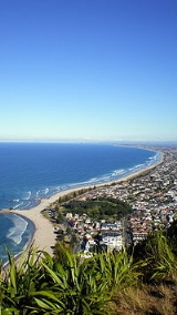
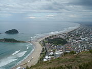
Mount Maunganui is a town in the Bay of Plenty
, New Zealand, located on a peninsula to the north of Tauranga
. It was independent from Tauranga until the completion of the Tauranga Harbour Bridge
in 1988.
Mount Maunganui is also the name of the extinct volcanic
cone that rises above the town, which is now officially known by its Māori
name Mauao, but is colloquially known in New Zealand simply as The Mount.
. Because of this formation, the residents of Mount Maunganui have both a harbour
beach (Pilot Bay) and an ocean beach with great surf, within a short distance. At the base of Mauao, the distance between the harbour and ocean side is a couple of blocks
.
The ocean beach has Mauao or Mount Maunganui at its western end, and a man made land bridge connecting Moturiki Island
at its eastern end.
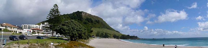
Mauao is an extinct volcanic
cone which rises above the town, but is colloquially known in New Zealand simply as The Mount. According to Maori legend, this hill was a pononga [slave] to a mountain called Otanewainuku. The conical headland which gives the town its name is 232 metres (761.2 ft) in height, and dominates the mostly flat surrounding countryside. It was formerly a Māori pā
, and the remains of trenches can be seen in the ridges, as well as ancient shell midden
s. Today, it is open to the public year round, and is a popular place to either walk around, or climb up. From the summit, a good stretch of coastline can be seen in either direction, as well as the Kaimai Range to the west.


 Mount Maunganui is regarded as a coastal resort town, although Port of Tauranga
, a major facility, is also partly located on the western (harbour) side. It is also well-known for the quality of its surfing
conditions, though parts of the beach are notoriously dangerous. The harbour bridge was opened in 1988, linking Mount Maunganui with Tauranga. The construction of a duplication bridge was completed in December 2009, forming a vital link in Tauranga and Mount Maunganui's growing motorway system.
A large container terminal and overseas wharf is located at Mount Maunganui. A branch railway from the East Coast Main Trunk railway runs between Te Maunga and Mount Maunganui.
Mount Maunganui also features the popular Bayfair shopping centre. The centre is one of the largest in the North Island outside Auckland and Wellington. It features a large Farmers
, Kmart
, Countdown
, Woolworths
, plus over 80 specialty stores and a food court all situated on 1 level.
The population of Mount Maunganui and suburbs was 30,387 in the 2001 census
. It is a well known holiday spot over the Christmas and summer months with new year some 20,000+ gather to see in the new year on the main beach, which is popular with the young.
Tauranga has a good number of cruise ships visits (36 in the 2010/11 season); even though it is the port of Tauranga, the port is on the Mount side of the harbour.
has been installed at the Mount. Construction of the reef was hampered by lack of funds and ironically, too many waves. Initially the public was told the reef would cost about $500k, but costs escalated to $800k, and could exceeded $1.5M. Recently the media has reported that local surfers are disappointed with the waves produced by the reef. The reef has also been blamed for creating rips
and may yet have to be removed.
Bay of Plenty
The Bay of Plenty , often abbreviated to BOP, is a region in the North Island of New Zealand situated around the body of water of the same name...
, New Zealand, located on a peninsula to the north of Tauranga
Tauranga
Tauranga is the most populous city in the Bay of Plenty region, in the North Island of New Zealand.It was settled by Europeans in the early 19th century and was constituted as a city in 1963...
. It was independent from Tauranga until the completion of the Tauranga Harbour Bridge
Tauranga Harbour Bridge
The Tauranga Harbour Bridge refers to two bridges that carry Te Awanui Drive over the Tauranga Harbour. Te Awanui Drive is part of an expressway that connects Tauranga to Mount Maunganui. On the Tauranga side, Te Awanui Drive connects to Takitimu Drive, which crosses the Chapel Street Viaduct...
in 1988.
Mount Maunganui is also the name of the extinct volcanic
Volcano
2. Bedrock3. Conduit 4. Base5. Sill6. Dike7. Layers of ash emitted by the volcano8. Flank| 9. Layers of lava emitted by the volcano10. Throat11. Parasitic cone12. Lava flow13. Vent14. Crater15...
cone that rises above the town, which is now officially known by its Māori
Maori language
Māori or te reo Māori , commonly te reo , is the language of the indigenous population of New Zealand, the Māori. It has the status of an official language in New Zealand...
name Mauao, but is colloquially known in New Zealand simply as The Mount.
Geography
Mount Maunganui is located on top of a sand bar that connects Mauao to the mainland, a geographical formation known as a tomboloTombolo
A tombolo, from the Italian tombolo, derived from the Latin tumulus, meaning 'mound,' and sometimes translated as ayre , is a deposition landform in which an island is attached to the mainland by a narrow piece of land such as a spit or bar. Once attached, the island is then known as a tied island...
. Because of this formation, the residents of Mount Maunganui have both a harbour
Tauranga Harbour
The Tauranga Harbour is the natural tidal harbour that surrounds Tauranga CBD and the Mount Maunganui area of Tauranga, New Zealand which flows into the Pacific Ocean at Mount Maunganui and Bowentown. The harbour is effectively two flooded river systems separated from the Pacific Ocean, by the...
beach (Pilot Bay) and an ocean beach with great surf, within a short distance. At the base of Mauao, the distance between the harbour and ocean side is a couple of blocks
City block
A city block, urban block or simply block is a central element of urban planning and urban design. A city block is the smallest area that is surrounded by streets. City blocks are the space for buildings within the street pattern of a city, they form the basic unit of a city's urban fabric...
.
The ocean beach has Mauao or Mount Maunganui at its western end, and a man made land bridge connecting Moturiki Island
Moturiki Island
Moturiki Island is located just off Mount Maunganui beach. It is connected to the beach by a man made land bridge. NIWA maintains a tide meter on Moturiki Island. Moturiki Island offers rock climbing opportunities....
at its eastern end.
Mauao is an extinct volcanic
Volcano
2. Bedrock3. Conduit 4. Base5. Sill6. Dike7. Layers of ash emitted by the volcano8. Flank| 9. Layers of lava emitted by the volcano10. Throat11. Parasitic cone12. Lava flow13. Vent14. Crater15...
cone which rises above the town, but is colloquially known in New Zealand simply as The Mount. According to Maori legend, this hill was a pononga [slave] to a mountain called Otanewainuku. The conical headland which gives the town its name is 232 metres (761.2 ft) in height, and dominates the mostly flat surrounding countryside. It was formerly a Māori pā
Pa (Maori)
The word pā can refer to any Māori village or settlement, but in traditional use it referred to hillforts fortified with palisades and defensive terraces and also to fortified villages. They first came into being about 1450. They are located mainly in the North Island north of lake Taupo...
, and the remains of trenches can be seen in the ridges, as well as ancient shell midden
Midden
A midden, is an old dump for domestic waste which may consist of animal bone, human excrement, botanical material, vermin, shells, sherds, lithics , and other artifacts and ecofacts associated with past human occupation...
s. Today, it is open to the public year round, and is a popular place to either walk around, or climb up. From the summit, a good stretch of coastline can be seen in either direction, as well as the Kaimai Range to the west.
History
The name Mount Maunganui was a 'rebranding' by early developers, changing it from the previous name of Rakataura, a name chosen by the first town board. Mount Maunganui fought fiercely during the 1950s to retain independence from Tauranga, then failed with the completion of the harbour bridge in 1988.Character
Port of Tauranga
Port of Tauranga is the port of Tauranga, New Zealand, the largest port in the country in terms of total cargo volume, and the second largest in terms of container throughput. with Port of Tauranga Ltd being the company operating it...
, a major facility, is also partly located on the western (harbour) side. It is also well-known for the quality of its surfing
Surfing
Surfing' is a surface water sport in which the surfer rides a surfboard on the crest and face of a wave which is carrying the surfer towards the shore...
conditions, though parts of the beach are notoriously dangerous. The harbour bridge was opened in 1988, linking Mount Maunganui with Tauranga. The construction of a duplication bridge was completed in December 2009, forming a vital link in Tauranga and Mount Maunganui's growing motorway system.
A large container terminal and overseas wharf is located at Mount Maunganui. A branch railway from the East Coast Main Trunk railway runs between Te Maunga and Mount Maunganui.
Mount Maunganui also features the popular Bayfair shopping centre. The centre is one of the largest in the North Island outside Auckland and Wellington. It features a large Farmers
Farmers (department store)
The Farmers Trading Company is a New Zealand mid-market department store chain. Based in Flat Bush in Auckland, Farmers operates 56 stores across New Zealand, specialising in fashion, beauty, home-wares and furniture.- History :...
, Kmart
Kmart Australia
Kmart Australia Limited is a discount department store chain owned by Wesfarmers. It operates 172 stores in Australia and 15 in New Zealand, with its head office located in Mulgrave, Victoria. Wesfarmers uses the Kmart name under licence from Sears Holdings Corporation.-History:Kmart Australia...
, Countdown
Countdown (supermarket)
Countdown is a New Zealand full-service supermarket chain, owned by Woolworths Limited. Founded in 1981, Countdown is now the flagship brand of Progressive Enterprises, Woolworths' New Zealand supermarket subsidiary, with 133 supermarkets across New Zealand...
, Woolworths
Woolworths Supermarkets (New Zealand)
Woolworths is a New Zealand supermarket chain and a unit of Woolworths Limited.- 1929 - 1979 Woolworths :Founded in 1929 by Percy Christmas, the chain was separated from the parent company Woolworths Limited in Australia and was called Woolworths New Zealand...
, plus over 80 specialty stores and a food court all situated on 1 level.
The population of Mount Maunganui and suburbs was 30,387 in the 2001 census
New Zealand Census of Population and Dwellings
The New Zealand government department Statistics New Zealand conducts a census of population and dwellings every five years. The census scheduled for 2011 was cancelled due to circumstances surrounding the February 2011 Christchurch earthquake, however, and legislation introduced to hold the next...
. It is a well known holiday spot over the Christmas and summer months with new year some 20,000+ gather to see in the new year on the main beach, which is popular with the young.
Tauranga has a good number of cruise ships visits (36 in the 2010/11 season); even though it is the port of Tauranga, the port is on the Mount side of the harbour.
Sporting events
Every year the Mt Maunganui beach hosts the Northern Regional Surf Championships (NRC's), and other events like the NZ Under 14 Ocean Athlete Championships and the Pro Volleyball Tour. The Port of Tauranga Half Ironman triathlon is held at Mt Maunganui.Artificial reef
New Zealand's first artificial reefArtificial reef
An artificial reef is a human-made underwater structure, typically built to promote marine life in areas with a generally featureless bottom, control erosion, block ship passage, or improve surfing....
has been installed at the Mount. Construction of the reef was hampered by lack of funds and ironically, too many waves. Initially the public was told the reef would cost about $500k, but costs escalated to $800k, and could exceeded $1.5M. Recently the media has reported that local surfers are disappointed with the waves produced by the reef. The reef has also been blamed for creating rips
Rip current
A rip current, commonly referred to by the misnomer rip tide, is a strong channel of water flowing seaward from near the shore, typically through the surf line. Typical flow is at 0.5 metres per second , and can be as fast as 2.5 metres per second...
and may yet have to be removed.
Climate
The climate is mild subtropic:- Summer = 20°C / 30°C. ( Jan/Feb )
- Winter = 10°C / 15°C. ( Jun/Jul )
- Frosts Avg/Yr = 12 ( -1°C -2°C ).
- Rainfall = 1280mm/Yr.Avg
- Sunshine = Min 2200hrs/Yr.
- Beach Temp avg.
- Summer = 21°C.
- Winter = 14°C.