

Manawatu River
Encyclopedia
North Island
The North Island is one of the two main islands of New Zealand, separated from the much less populous South Island by Cook Strait. The island is in area, making it the world's 14th-largest island...
of New Zealand
New Zealand
New Zealand is an island country in the south-western Pacific Ocean comprising two main landmasses and numerous smaller islands. The country is situated some east of Australia across the Tasman Sea, and roughly south of the Pacific island nations of New Caledonia, Fiji, and Tonga...
.
The river has its headwaters to the northwest of Norsewood
Norsewood
Norsewood is a small rural town in the Manawatu - Wanganui region of New Zealand's North Island. It is situated in the Tararua District. Its population is 330....
in the Ruahine Ranges of southern Hawke's Bay
Hawke's Bay
Hawke's Bay is a region of New Zealand. Hawke's Bay is recognised on the world stage for its award-winning wines. The regional council sits in both the cities of Napier and Hastings.-Geography:...
. It flows initially eastward before turning south-west near Ormondville, flowing 40 km before turning north-west near Woodville
Woodville, New Zealand
Woodville is a small town in the southern North Island of New Zealand, 75 km north of Masterton and 25 km east of Palmerston North. In the 2006 census 1,398 people are usually resident in Woodville, a decrease of 81 people, or 5.5%, since the 2001 Census.-Early History and Local...
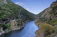
. At this point the river enters the Manawatu Gorge
Manawatu Gorge
The Manawatu Gorge runs between the Ruahine and Tararua Ranges of the North Island of New Zealand, linking the Manawatu and Hawke's Bay regions...
. Beyond the gorge it again turns south-west, flowing through the city of Palmerston North
Palmerston North
Palmerston North is the main city of the Manawatu-Wanganui region of the North Island of New Zealand. It is an inland city with a population of and is the country's seventh largest city and eighth largest urban area. Palmerston North is located in the eastern Manawatu Plains near the north bank...
before entering the Tasman Sea
Tasman Sea
The Tasman Sea is the large body of water between Australia and New Zealand, approximately across. It extends 2,800 km from north to south. It is a south-western segment of the South Pacific Ocean. The sea was named after the Dutch explorer Abel Janszoon Tasman, the first recorded European...
at Foxton Beach
Foxton Beach
Foxton Beach is a small settlement in the Horowhenua District of the Manawatu-Wanganui region of New Zealand's North Island. It is located on the South Taranaki Bight at the mouth of the Manawatu River, 35 kilometres southwest of Palmerston North, and six kilometres west of Foxton. Foxton Beach...
.
The river, along with the more northern Whanganui River
Whanganui River
The Whanganui River is a major river in the North Island of New Zealand.Known for many years as the Wanganui River, the river's name reverted to Whanganui in 1991, according with the wishes of local iwi. Part of the reason was also to avoid confusion with the Wanganui River in the South Island...
, gives its name to the Manawatu-Wanganui
Manawatu-Wanganui
Manawatu-Wanganui is a region in the lower half of the North Island of New Zealand, around the cities of Palmerston North and Whanganui. It is administered by the Horizons Regional Council.-Administration:...
region. The river's name comes from the Māori words manawa (heart, spirit) and tū (stand still, or depressed), therefore heart standing still with fear, or depressed spirit. Haunui was in pursuit of his wife and arrived at this river clutching his chest when he named this river.
Physical environment
The river is unique among New Zealand rivers, starting on the east side of the main dividing range and having its outflow to the west. The explanation for this is the uplift of the central ranges. The ranges moved upwards at the same time as the gorge was eroded by the river, instead of the more usual erosion of an already existing range. This suggests that the river is an old one, as it must have existed before the Ruahine and Tararua Ranges.Major tributaries of the river include the Makakahi
Makakahi River
The Makakahi River is in the Manawatu-Wanganui region of the North Island of New Zealand.Its headwaters are to the south of Eketahuna. From there, it flows northwest alongside State Highway 2 for 40 kilometres, before feeding into the Manawatu River between Pahiatua and Woodville....
, Mangahao
Mangahao River
The Mangahao River is located in the North Island of New Zealand.The headwaters are in the Tararua Ranges and feeds into the Manawatu River south of Woodville.There is a hydroelectric power station dam on the river....
, Pohangina
Pohangina River
The Pohangina River is a river of the southwestern North Island of New Zealand. A tributary of the Manawatu River, it flows generally southward from its source in the Ruahine Range, joining the Manawatu River about 15 km northeast of Palmerston North at Ashhurst. Brown and rainbow trout live in...
and Oroua River
Oroua River
The Oroua River is a river of the southwestern North Island of New Zealand. A tributary of the Manawatu River, it flows generally southwestward from its source in the Ruahine Range, joining the Manawatu River between Palmerston North and Shannon....
s. The Manawatu's total length is 180 km, making it only the 12th-longest in the country, but at 102 m³/s it is one of the country's greatest rivers in terms of flow, and second only to the Waikato River
Waikato River
The Waikato River is the longest river in New Zealand. In the North Island, it runs for 425 kilometres from the eastern slopes of Mount Ruapehu, joining the Tongariro River system and emptying into Lake Taupo, New Zealand's largest lake. It drains Taupo at the lake's northeastern edge, creates the...
among North Island rivers.
The Manawatu River flooded in February 2004, displacing over 2000 people (primarily from Marton
Marton, New Zealand
Marton is the hub of the Rangitikei district of the Manawatu-Wanganui region of New Zealand's North Island. It is situated 35 kilometres southeast of Wanganui and 40 kilometres northwest of Palmerston North. The population was 4752 .-History:...
and Feilding
Feilding, New Zealand
Feilding is a town in the Manawatu-Wanganui Region of the North Island of New Zealand. It is located on State Highway 54, 20 kilometres north of Palmerston North....
) and damaging over 1000 Manawatu farms. The cost of the flood in terms of insurance payouts was NZ$122 million. Further damage was prevented by the opening of the Moutoa floodgate
Floodgate
Floodgates are adjustable gates used to control water flow in flood barriers, reservoir, river, stream, or levee systems. They may be designed to set spillway crest heights in dams, to adjust flow rates in sluices and canals, or they may be designed to stop water flow entirely as part of a levee or...
s, which intercept the river between Foxton
Foxton, New Zealand
Foxton is a town in the Manawatu-Wanganui region of New Zealand. The 2006 census population was 2715.It is located on the lower west coast of the North Island, in the Horowhenua district, 30 kilometres southwest of Palmerston North and 15 kilometres north of Levin. The town is located close to the...
and Shannon
Shannon, New Zealand
Shannon is a small town in the Horowhenua District of New Zealand's North Island. it is located 28 kilometres southwest of Palmerston North and 15 kilometres northeast of Levin. The town's population at the 2006 census was 1506....
.
Water quality
The river is heavily polluted with industrial waste, treated sewage, and, most particularly, nutrient land runoff from dairy farms. In 2006 FonterraFonterra
Fonterra Co-operative Group Limited is a New Zealand multinational dairy co-operative owned by almost 10,500 New Zealand farmers. The company is responsible for approximately 30% of the world's dairy exports and with revenue exceeding NZ$19.87 billion, is New Zealand's largest company.- History :In...
were criticised for an application to discharge 8500 m3 of wastewater into the Manawatu River. In 2009, the Cawthron Institute found that the river had the highest gross primary production (GPP) compared to 300 rivers and streams in the Western world. High GPP rates are an indication of poor ecological health
Ecological health
Ecological health or ecological integrity or ecological damage are the symptoms of an ecosystem's pending loss of carrying capacity, its ability to perform ecological services, or a pending ecocide, due to cumulative causes such as pollution. it can also be defined as farming so as to minimize the...
and can lead to various environmental issue
Environmental issue
Environmental issues are negative aspects of human activity on the biophysical environment. Environmentalism, a social and environmental movement that started in the 1960s, addresses environmental issues through advocacy, education and activism.-Types:...
s. A report by the Ministry for the Environment ranked 76 New Zealand sites for water clarity and E. coli
Escherichia coli
Escherichia coli is a Gram-negative, rod-shaped bacterium that is commonly found in the lower intestine of warm-blooded organisms . Most E. coli strains are harmless, but some serotypes can cause serious food poisoning in humans, and are occasionally responsible for product recalls...
levels. Using those measures, they found four other New Zealand rivers rate worse than the Manawatu (the Waitara
Waitara River
The source of the Waitara River lies in the very steep hill country to the east of Mount Taranaki/Egmont, near Tahora. After proceeding in a southwesterly direction toward Central Taranaki, the river abruptly turns to flow in a northeasterly direction to the Tasman Sea: meeting it at the coastal...
, Whanganui
Whanganui River
The Whanganui River is a major river in the North Island of New Zealand.Known for many years as the Wanganui River, the river's name reverted to Whanganui in 1991, according with the wishes of local iwi. Part of the reason was also to avoid confusion with the Wanganui River in the South Island...
, Waipa
Waipa River
The Waipa River is in the Waikato region of the North Island of New Zealand. The headwaters are in the Rangitoto Range east of Te Kuiti. It flows north for 115 kilometres, passing through Otorohanga and Pirongia, before flowing into the Waikato River at Ngaruawahia...
and Rangitikei
Rangitikei River
The Rangitikei River is one of New Zealand's longest rivers, 185 kilometers long.Its headwaters are to the southeast of Lake Taupo in the Kaimanawa Ranges. It flows from the Central Plateau south past Taihape, Mangaweka, Hunterville, Marton, and Bulls, to the South Taranaki Bight at Tangimoana, 40...
).