

Kaimai Ranges
Encyclopedia
North Island
The North Island is one of the two main islands of New Zealand, separated from the much less populous South Island by Cook Strait. The island is in area, making it the world's 14th-largest island...
of New Zealand
New Zealand
New Zealand is an island country in the south-western Pacific Ocean comprising two main landmasses and numerous smaller islands. The country is situated some east of Australia across the Tasman Sea, and roughly south of the Pacific island nations of New Caledonia, Fiji, and Tonga...
. It is part of a series of ranges, with the Coromandel Range
Coromandel Range
right|thumb|250px|A true-colour image showing Auckland city , the Hauraki Gulf and the Coromandel Peninsula . The scene was acquired by NASA's Terra satellite, on October 23, 2002.The Coromandel Range is a ridge of rugged hills running the length of the Coromandel Peninsula in the North Island of...
to the north and the Mamaku Ranges
Mamaku Ranges
The Mamaku Ranges are a range of rugged hills in the North Island of New Zealand. Located to the west of Lake Rotorua and north of Lake Taupo, they lie to the immediate south of the Kaimai Range and can be thought of as an extension of it, in much the same way that the Kaimai Range can be...
to the south. The Kaimai Range separates the Waikato
Waikato
The Waikato Region is a local government region of the upper North Island of New Zealand. It covers the Waikato, Hauraki, Coromandel Peninsula, the northern King Country, much of the Taupo District, and parts of Rotorua District...
in the west from the Bay of Plenty
Bay of Plenty
The Bay of Plenty , often abbreviated to BOP, is a region in the North Island of New Zealand situated around the body of water of the same name...
in the east.
The highest point of the range is Mount Te Aroha (952 m), at the foot of which is the town of Te Aroha
Te Aroha
Te Aroha is a rural town in the Waikato region of New Zealand with a population of 3,768 . It is 53 km northeast of Hamilton and 50 km south of Thames. It sits at the foot of 952-metre Mount Te Aroha, the highest point in the Kaimai Range....
. The range's terrain is rough, and only two roads pass over it: State Highway 2
New Zealand State Highway network
The New Zealand State Highway network is the major national highway network in New Zealand. Just under 100 roads in both the North and South Islands are State Highways...
, across the northern end of the range through Karangahake Gorge
Karangahake Gorge
The Karangahake Gorge lies between the Coromandel and Kaimai ranges, at the southern end of the Coromandel Peninsula in New Zealand's North Island. A sharply winding canyon, it was formed by the Ohinemuri River. State Highway 2 passes through this gorge between the towns of Paeroa, Waikino and Waihi...
, and State Highway 29
New Zealand State Highway network
The New Zealand State Highway network is the major national highway network in New Zealand. Just under 100 roads in both the North and South Islands are State Highways...
from Tauranga
Tauranga
Tauranga is the most populous city in the Bay of Plenty region, in the North Island of New Zealand.It was settled by Europeans in the early 19th century and was constituted as a city in 1963...
to Hamilton
Hamilton, New Zealand
Hamilton is the centre of New Zealand's fourth largest urban area, and Hamilton City is the country's fourth largest territorial authority. Hamilton is in the Waikato Region of the North Island, approximately south of Auckland...
.
Geology
The Kaimai Range is the result of a fault that uplifted primarily andesiticAndesite
Andesite is an extrusive igneous, volcanic rock, of intermediate composition, with aphanitic to porphyritic texture. In a general sense, it is the intermediate type between basalt and dacite. The mineral assemblage is typically dominated by plagioclase plus pyroxene and/or hornblende. Magnetite,...
rocks from long-extinct volcanoes. This fault has not been active for about 140,000 years and started more than a million years ago.
Kaimai Tunnel
The Kaimai Railway TunnelKaimai Tunnel
The Kaimai Tunnel is a railway tunnel through the Kaimai Range in the North Island of New Zealand. Since it was opened in 1978, it has held the title of longest tunnel in New Zealand, assuming this distinction from the previous title holder, the Rimutaka Tunnel...
runs for nearly nine kilometres under the range, making it the longest tunnel in New Zealand. Construction of the tunnel started from both sides of the range in 1969: the headings met in 1976 and the tunnel opened on 12 September 1978. The Kaimai Range and this tunnel led to a Silver Fern
NZR RM class (Silver Fern)
This article is about the New Zealand railcar service and the railcars themselves. For other uses, see Silver Fern .The NZR RM class Silver Fern is a class of railcar in New Zealand. The three air-conditioned and sound-proofed 723-kW 96-seater diesel-electric twin-set railcars were built by...
railcar
Railcar
A railcar, in British English and Australian English, is a self-propelled railway vehicle designed to transport passengers. The term "railcar" is usually used in reference to a train consisting of a single coach , with a driver's cab at one or both ends. Some railways, e.g., the Great Western...
service between Auckland and Tauranga being named the Kaimai Express
Kaimai Express (train)
The Kaimai Express was a long-distance passenger train operated by the Tranz Scenic division of Tranz Rail that ran between the North Island cities of Auckland and Tauranga via Hamilton...
. This service operated from 1991 until 2001.
A peak of the Kaimai directly above the tunnel, previously unnamed, was named Stokes Peak in 2010 in honour of geographer Evelyn Stokes
Evelyn Stokes
Dame Evelyn Mary Stokes, DNZM was a professor of geography at the University of Waikato in New Zealand and a member of the New Zealand government's Waitangi Tribunal...
.
Flight 441 disaster
At approximately 9:09 am on 3 July 1963 the DC-3 Skyliner ZK-AYZ Hastings operating New Zealand National Airways Corporation Flight 441New Zealand National Airways Corporation Flight 441
New Zealand National Airways Corporation Flight 441 was a scheduled flight of New Zealand's National Airways Corporation from Whenuapai to Tauranga. On 3 July 1963 at approximately 9:09 am NZST the flight, a Douglas DC-3 Skyliner, flew into a vertical rock face in the Kaimai Ranges near Mount...
from Whenuapai Airport, Auckland to Tauranga crashed into the range. All 23 aboard died, making it the worst air disaster in mainland New Zealand.
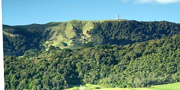
Communications
The New Zealand Post OfficeNew Zealand Post Office
The New Zealand Post Office was a New Zealand government department.As a Government Department, the New Zealand Post Office or N.Z.P.O., previously the Post and Telegraph Department or P & T, had as the political head the Postmaster General who was a member of Cabinet, and, when it was a separate...
engineering division (radio) built and maintained a microwave communications facility near the top of Kaimai range, close to the Hamilton
Hamilton, New Zealand
Hamilton is the centre of New Zealand's fourth largest urban area, and Hamilton City is the country's fourth largest territorial authority. Hamilton is in the Waikato Region of the North Island, approximately south of Auckland...
–Tauranga
Tauranga
Tauranga is the most populous city in the Bay of Plenty region, in the North Island of New Zealand.It was settled by Europeans in the early 19th century and was constituted as a city in 1963...
highway saddle. In the 1960s it was a Lenkurt relay as part of the national network, linking Sanitorium Hill near Cambridge
Cambridge
The city of Cambridge is a university town and the administrative centre of the county of Cambridgeshire, England. It lies in East Anglia about north of London. Cambridge is at the heart of the high-technology centre known as Silicon Fen – a play on Silicon Valley and the fens surrounding the...
to Rotorua
Rotorua
Rotorua is a city on the southern shores of the lake of the same name, in the Bay of Plenty region of the North Island of New Zealand. The city is the seat of the Rotorua District, a territorial authority encompassing the city and several other nearby towns...
, with a spur to Tauranga. It now has cell phone and various other radio communications facilities, and is owned and operated by Telecom New Zealand
Telecom New Zealand
Telecom New Zealand is a New Zealand-wide communications service provider , providing fixed line telephone services, a mobile network, an internet service provider , a major ICT provider to NZ businesses , and a wholesale network infrastructure provider to other NZ CSPs...
. Land Parcel: Part Section 126 Block II Tapapa SD http://www.mpdc.govt.nz/PoliciesPlans/districtplan/districtplan.6.htm
See also
- Tunnels in New ZealandTunnels in New ZealandThis is a link page for railway, road and waterway tunnels, including hydroelectric intakes and tailraces and gun battery tunnels. It includes artificial chambers but excludes New Zealand caves and New Zealand mines.-For hydroelectric usage:...
- Matamata-Piako DistrictMatamata-Piako DistrictThe Matamata-Piako District is a local government area in the Waikato region of New Zealand. It lies to the east of the city of Hamilton.The district encompasses the southern end of the Hauraki Plains and much of the Thames Valley, and is bounded in the east by the Kaimai Range...
- Western Bay of Plenty DistrictWestern Bay of Plenty District200px|rightThe Western Bay of Plenty District Council is a municipality in the Bay of Plenty Region of New Zealand. The seat of the district council is at Greerton in Tauranga City...
- Ohinemuri RiverOhinemuri RiverThe Ohinemuri River is located in the north of New Zealand's North Island.The river source is north-east of the town of Waihi, close to the shore of the Bay of Plenty, but flows west rather than into the bay. It runs through the steep-sided Karangahake Gorge, forming a break between the Coromandel...