
National Mine Map Repository
Encyclopedia
The National Mine Map Repository
(NMMR)http://mmr.osmre.gov/Default.aspx is part of the United States Department of the Interior
(DOI), Office of Surface Mining Reclamation and Enforcement
(OSMRE or OSM). The NMMR resides in Green Tree, Pennsylvania
, and collects and maintains mine map information and images for the entire country, including data and maps of coal
mines in the anthracite coal region of northeastern Pennsylvania. The Green Tree facility provides and stores, digitally and in microfilm
(aperture cards
) , over 150,000 maps of abandoned mines. This repository contains maps from the 1850s to the present day. It serves as a point of reference for mine maps and other information for both surface and underground mines throughout the United States. It also serves as a location to retrieve mine maps in an emergency. The NMMR provides services ranging from retrieving mine related data for economic analysis to assessing the potential risk associated with underground mining. Through analysis of mine maps and related information, the repository assists private and public sectors in industrial and commercial development, highway construction, and the preservation of public health, safety, and welfare. In addition, they collect, reproduce, and maintain a national inventory of mine maps and supporting documentation for private and public interests.
(BOM) in 1970. A repository was set up at a BOM office in Pittsburgh and Wilkes-Barre , Pennsylvania and covered all states east of the Mississippi River
with the exception of Louisiana
and Minnesota
. These two states, together with Arizona
, New Mexico
, North Dakota
, South Dakota
, Wyoming
, Utah
, Colorado
, Missouri
, and Kansas
, were covered by a separate repository at the BOM Intermountain Field Operation Center in Denver, Colorado
. A fourth repository, in Spokane, Washington, held the mining archives for the western states of Washington, Oregon
, California
, Nevada
, Montana
, and Idaho
.
In 1982 the responsibility of maintaining the repository and its staff was formally transferred to DOI's Office of Surface Mining Reclamation and Enforcement. Later, when BOM was dissolved in 1996, all of the maps from the BOM offices were consolidated into the current OSM Pittsburgh repository. The Wilkes-Barre repository was closed in 2011, and its collection transferred to the Pittsburgh office, which is designated as the National Mine Map Repository.
The mission of the repository has always been to obtain authoritative maps on past and current mining operations and preserve them on microfilm. Higher priority is given to maps of mines in areas where the potential for adverse impact to the environment is more significant. The NMMR, in addition to being an archival entity concerned with the preservation of mine maps, is also a basic reference file of information on mines. The information is made available to federal and state geological surveys, state mining bureaus, mining companies, oil and gas companies, conservationists, research and planning organizations, water pollution boards, city and industrial planners, highway engineers, building contractors, real estate developers and private citizens.
Today the NMMR facility is equipped with modern map scanning and archiving capability to digitize maps. The primary archival method remains microfilm although the repository's holdings are increasingly available in digital format.
 The NMMR contains digital and microfilm maps of surface and underground coal, metal, and non-metal mines throughout the United States. Some of the information that can be obtained from the repository includes:
When maps are received from a donor, they are scanned and stored in both microfilm and digital archives. The maps, along with a scanned images (upon request), are returned to the donor. The repository does not retain hard copies of maps.
); company name; mine type; and both the Universal Transverse Mercator (UTM
) grid zone and the latitude and longitude of the geo-located point on the map. This information is input into the Mine Map Index System. The sorted maps are then scanned into a digital format and stored on the repository's dedicated 500 terabyte
mass storage array
.
The NMMR utilizes different types of scanning equipment
to facilitate archiving mine maps made available in a variety of media.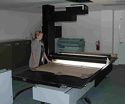
Small, portable aperture card scanners are shipped to state agencies as part of an extensive initiative to map underground mines.
Repository (publishing)
A repository in publishing, and especially in academic publishing,is a real or virtual facility for the deposit of academic publications, such as academic journal articles....
(NMMR)http://mmr.osmre.gov/Default.aspx is part of the United States Department of the Interior
United States Department of the Interior
The United States Department of the Interior is the United States federal executive department of the U.S. government responsible for the management and conservation of most federal land and natural resources, and the administration of programs relating to Native Americans, Alaska Natives, Native...
(DOI), Office of Surface Mining Reclamation and Enforcement
Office of Surface Mining
The Office of Surface Mining Reclamation and Enforcement is a branch of the United States Department of the Interior...
(OSMRE or OSM). The NMMR resides in Green Tree, Pennsylvania
Pennsylvania
The Commonwealth of Pennsylvania is a U.S. state that is located in the Northeastern and Mid-Atlantic regions of the United States. The state borders Delaware and Maryland to the south, West Virginia to the southwest, Ohio to the west, New York and Ontario, Canada, to the north, and New Jersey to...
, and collects and maintains mine map information and images for the entire country, including data and maps of coal
Coal
Coal is a combustible black or brownish-black sedimentary rock usually occurring in rock strata in layers or veins called coal beds or coal seams. The harder forms, such as anthracite coal, can be regarded as metamorphic rock because of later exposure to elevated temperature and pressure...
mines in the anthracite coal region of northeastern Pennsylvania. The Green Tree facility provides and stores, digitally and in microfilm
Aperture card
An aperture card is a type of punched card with a cut-out window into which a chip of microfilm is mounted. Such a card is used for archiving or for making multiple inexpensive copies of a document for ease of distribution...
(aperture cards
Aperture card
An aperture card is a type of punched card with a cut-out window into which a chip of microfilm is mounted. Such a card is used for archiving or for making multiple inexpensive copies of a document for ease of distribution...
) , over 150,000 maps of abandoned mines. This repository contains maps from the 1850s to the present day. It serves as a point of reference for mine maps and other information for both surface and underground mines throughout the United States. It also serves as a location to retrieve mine maps in an emergency. The NMMR provides services ranging from retrieving mine related data for economic analysis to assessing the potential risk associated with underground mining. Through analysis of mine maps and related information, the repository assists private and public sectors in industrial and commercial development, highway construction, and the preservation of public health, safety, and welfare. In addition, they collect, reproduce, and maintain a national inventory of mine maps and supporting documentation for private and public interests.
History of the NMMR
The Federal Coal Mine Health and Safety Act of 1969 established a national mine map repository. The repository was funded by and assigned to the Department of the Interior, Bureau of MinesUnited States Bureau of Mines
For most of the 20th century, the U.S. Bureau of Mines was the primary United States Government agency conducting scientific research and disseminating information on the extraction, processing, use, and conservation of mineral resources.- Summary :...
(BOM) in 1970. A repository was set up at a BOM office in Pittsburgh and Wilkes-Barre , Pennsylvania and covered all states east of the Mississippi River
Mississippi River
The Mississippi River is the largest river system in North America. Flowing entirely in the United States, this river rises in western Minnesota and meanders slowly southwards for to the Mississippi River Delta at the Gulf of Mexico. With its many tributaries, the Mississippi's watershed drains...
with the exception of Louisiana
Louisiana
Louisiana is a state located in the southern region of the United States of America. Its capital is Baton Rouge and largest city is New Orleans. Louisiana is the only state in the U.S. with political subdivisions termed parishes, which are local governments equivalent to counties...
and Minnesota
Minnesota
Minnesota is a U.S. state located in the Midwestern United States. The twelfth largest state of the U.S., it is the twenty-first most populous, with 5.3 million residents. Minnesota was carved out of the eastern half of the Minnesota Territory and admitted to the Union as the thirty-second state...
. These two states, together with Arizona
Arizona
Arizona ; is a state located in the southwestern region of the United States. It is also part of the western United States and the mountain west. The capital and largest city is Phoenix...
, New Mexico
New Mexico
New Mexico is a state located in the southwest and western regions of the United States. New Mexico is also usually considered one of the Mountain States. With a population density of 16 per square mile, New Mexico is the sixth-most sparsely inhabited U.S...
, North Dakota
North Dakota
North Dakota is a state located in the Midwestern region of the United States of America, along the Canadian border. The state is bordered by Canada to the north, Minnesota to the east, South Dakota to the south and Montana to the west. North Dakota is the 19th-largest state by area in the U.S....
, South Dakota
South Dakota
South Dakota is a state located in the Midwestern region of the United States. It is named after the Lakota and Dakota Sioux American Indian tribes. Once a part of Dakota Territory, South Dakota became a state on November 2, 1889. The state has an area of and an estimated population of just over...
, Wyoming
Wyoming
Wyoming is a state in the mountain region of the Western United States. The western two thirds of the state is covered mostly with the mountain ranges and rangelands in the foothills of the Eastern Rocky Mountains, while the eastern third of the state is high elevation prairie known as the High...
, Utah
Utah
Utah is a state in the Western United States. It was the 45th state to join the Union, on January 4, 1896. Approximately 80% of Utah's 2,763,885 people live along the Wasatch Front, centering on Salt Lake City. This leaves vast expanses of the state nearly uninhabited, making the population the...
, Colorado
Colorado
Colorado is a U.S. state that encompasses much of the Rocky Mountains as well as the northeastern portion of the Colorado Plateau and the western edge of the Great Plains...
, Missouri
Missouri
Missouri is a US state located in the Midwestern United States, bordered by Iowa, Illinois, Kentucky, Tennessee, Arkansas, Oklahoma, Kansas and Nebraska. With a 2010 population of 5,988,927, Missouri is the 18th most populous state in the nation and the fifth most populous in the Midwest. It...
, and Kansas
Kansas
Kansas is a US state located in the Midwestern United States. It is named after the Kansas River which flows through it, which in turn was named after the Kansa Native American tribe, which inhabited the area. The tribe's name is often said to mean "people of the wind" or "people of the south...
, were covered by a separate repository at the BOM Intermountain Field Operation Center in Denver, Colorado
Colorado
Colorado is a U.S. state that encompasses much of the Rocky Mountains as well as the northeastern portion of the Colorado Plateau and the western edge of the Great Plains...
. A fourth repository, in Spokane, Washington, held the mining archives for the western states of Washington, Oregon
Oregon
Oregon is a state in the Pacific Northwest region of the United States. It is located on the Pacific coast, with Washington to the north, California to the south, Nevada on the southeast and Idaho to the east. The Columbia and Snake rivers delineate much of Oregon's northern and eastern...
, California
California
California is a state located on the West Coast of the United States. It is by far the most populous U.S. state, and the third-largest by land area...
, Nevada
Nevada
Nevada is a state in the western, mountain west, and southwestern regions of the United States. With an area of and a population of about 2.7 million, it is the 7th-largest and 35th-most populous state. Over two-thirds of Nevada's people live in the Las Vegas metropolitan area, which contains its...
, Montana
Montana
Montana is a state in the Western United States. The western third of Montana contains numerous mountain ranges. Smaller, "island ranges" are found in the central third of the state, for a total of 77 named ranges of the Rocky Mountains. This geographical fact is reflected in the state's name,...
, and Idaho
Idaho
Idaho is a state in the Rocky Mountain area of the United States. The state's largest city and capital is Boise. Residents are called "Idahoans". Idaho was admitted to the Union on July 3, 1890, as the 43rd state....
.
In 1982 the responsibility of maintaining the repository and its staff was formally transferred to DOI's Office of Surface Mining Reclamation and Enforcement. Later, when BOM was dissolved in 1996, all of the maps from the BOM offices were consolidated into the current OSM Pittsburgh repository. The Wilkes-Barre repository was closed in 2011, and its collection transferred to the Pittsburgh office, which is designated as the National Mine Map Repository.
The mission of the repository has always been to obtain authoritative maps on past and current mining operations and preserve them on microfilm. Higher priority is given to maps of mines in areas where the potential for adverse impact to the environment is more significant. The NMMR, in addition to being an archival entity concerned with the preservation of mine maps, is also a basic reference file of information on mines. The information is made available to federal and state geological surveys, state mining bureaus, mining companies, oil and gas companies, conservationists, research and planning organizations, water pollution boards, city and industrial planners, highway engineers, building contractors, real estate developers and private citizens.
Today the NMMR facility is equipped with modern map scanning and archiving capability to digitize maps. The primary archival method remains microfilm although the repository's holdings are increasingly available in digital format.
Information available
- Mine and company names
- Underground mine plans
- Mains, rooms, and pillarsRoom and pillarRoom and pillar is a mining system in which the mined material is extracted across a horizontal plane while leaving "pillars" of untouched material to support the roof overburden leaving open areas or "rooms" underground...
- Man-ways, shaftsShaft miningShaft mining or shaft sinking refers to the method of excavating a vertical or near-vertical tunnel from the top down, where there is initially no access to the bottom....
, mine surface openingsAditAn adit is an entrance to an underground mine which is horizontal or nearly horizontal, by which the mine can be entered, drained of water, and ventilated.-Construction:...
, barrier pillars and ventilation facilities
- Mains, rooms, and pillars
- Closure (final) maps
- Adjacent mines
- Geological information
- BedStratumIn geology and related fields, a stratum is a layer of sedimentary rock or soil with internally consistent characteristics that distinguish it from other layers...
name, bed thickness, depth, drill holeWellboreA wellbore is any hole drilled for the purpose of exploration or extraction of natural resources such as water, gas or oil where a well may be produced and a resource is extracted for a protracted period of time....
data, cross-sections, elevation contoursContour lineA contour line of a function of two variables is a curve along which the function has a constant value. In cartography, a contour line joins points of equal elevation above a given level, such as mean sea level...
, structures, outcropsOutcropAn outcrop is a visible exposure of bedrock or ancient superficial deposits on the surface of the Earth. -Features:Outcrops do not cover the majority of the Earth's land surface because in most places the bedrock or superficial deposits are covered by a mantle of soil and vegetation and cannot be...
, assaysAssayAn assay is a procedure in molecular biology for testing or measuring the activity of a drug or biochemical in an organism or organic sample. A quantitative assay may also measure the amount of a substance in a sample. Bioassays and immunoassays are among the many varieties of specialized...
- Bed
- Geographical data
- Abandoned railroad lines and stations, coal townsCompany townA company town is a town or city in which much or all real estate, buildings , utilities, hospitals, small businesses such as grocery stores and gas stations, and other necessities or luxuries of life within its borders are owned by a single company...
, surface facilities, roads, ponds, streams, and property survey points
- Abandoned railroad lines and stations, coal towns
- Districts, townships, sections, rangesPublic Land Survey SystemThe Public Land Survey System is a method used in the United States to survey and identify land parcels, particularly for titles and deeds of rural, wild or undeveloped land. Its basic units of area are the township and section. It is sometimes referred to as the rectangular survey system,...
, counties and municipalities, latitudes and longitudes, elevation bench marks, and surface elevations - Gas well, oil well, and drill hole locations
Map acquisition and archiving
The NMMR acquires maps through public outreach directed at state and federal environmental agencies as well as mining companies, engineering and consulting firms, surveying companies, universities, and private citizens. The repository is constantly seeking donations of mine maps to add to the microfilm/digital collection .When maps are received from a donor, they are scanned and stored in both microfilm and digital archives. The maps, along with a scanned images (upon request), are returned to the donor. The repository does not retain hard copies of maps.
NMMR Procedures
As maps are obtained at the repository, they are assigned a unique six-digit identification number (document number). Data sheets are prepared for each map giving all available information including: map document number; state; county; mine name; mine ID number (MSHAMine Safety and Health Administration
The Mine Safety and Health Administration is an agency of the United States Department of Labor which administers the provisions of the Federal Mine Safety and Health Act of 1977 to enforce compliance with mandatory safety and health standards as a means to eliminate fatal accidents, to reduce...
); company name; mine type; and both the Universal Transverse Mercator (UTM
Universal Transverse Mercator coordinate system
The Universal Transverse Mercator geographic coordinate system uses a 2-dimensional Cartesian coordinate system to give locations on the surface of the Earth. It is a horizontal position representation, i.e...
) grid zone and the latitude and longitude of the geo-located point on the map. This information is input into the Mine Map Index System. The sorted maps are then scanned into a digital format and stored on the repository's dedicated 500 terabyte
Terabyte
The terabyte is a multiple of the unit byte for digital information. The prefix tera means 1012 in the International System of Units , and therefore 1 terabyte is , or 1 trillion bytes, or 1000 gigabytes. 1 terabyte in binary prefixes is 0.9095 tebibytes, or 931.32 gibibytes...
mass storage array
Array
In computer science, an array data structure or simply array is a data structure consisting of a collection of elements , each identified by at least one index...
.
The NMMR utilizes different types of scanning equipment
Image scanner
In computing, an image scanner—often abbreviated to just scanner—is a device that optically scans images, printed text, handwriting, or an object, and converts it to a digital image. Common examples found in offices are variations of the desktop scanner where the document is placed on a glass...
to facilitate archiving mine maps made available in a variety of media.
- 2 Cruse Table Scanners: CD 285/1100 ST/FA; CS 220 ST
- Scan area: 58x90"; 48x72"
- Black and white, 8 or 16 bit grayscaleGrayscaleIn photography and computing, a grayscale or greyscale digital image is an image in which the value of each pixel is a single sample, that is, it carries only intensity information...
, 24 or 48 bit color; b/w, grayscale, 36 bit color - 220-630 dpiDots per inchDots per inch is a measure of spatial printing or video dot density, in particular the number of individual dots that can be placed in a line within the span of 1 inch . The DPI value tends to correlate with image resolution, but is related only indirectly.- DPI measurement in monitor...
- File size 1.1GGigabyteThe gigabyte is a multiple of the unit byte for digital information storage. The prefix giga means 109 in the International System of Units , therefore 1 gigabyte is...
- TouchTableTouchTableTouchTable, Inc. is a United States company based in Pasadena that designs and manufactures interactive displays called TouchTables. The company also develops software products that run on the display. The company was founded as a spinoff of Applied Minds in May, 2006.A TouchTable was featured on...
- 46” 1080p display
- 1920 x 1080 pixel native resolutionResolutionResolution may refer to:* Resolution , a measure of digital audio quality* Resolution , a rule of inference used for automated theorem proving* Resolution , a written motion adopted by a deliberative body...
- High brightness (450 nits)
- High contrast (800:1)
- Displays data on a touch-sensitive table surface
- Geographically separated teams can visualize and share ideas in real-time
- 5 Wicks and Wilson C-Series aperture card scanners
- Up to 400 dpi
- Black and white, or grayscale
- Programmable reduction ratio
- 2 scanners have ability to auto-feed
- Scan silverSilver halideA silver halide is one of the compounds formed between silver and one of the halogens — silver bromide , chloride , iodide , and three forms of silver fluorides. As a group, they are often referred to as the silver halides, and are often given the pseudo-chemical notation AgX...
or diazoWhiteprintWhiteprint is the commercial terminology to describe document reproduction using the diazo chemical process. It is also known as the blue-line or blue-line process...
film
- Colortrac Gx+ T56 extra-wide format scanner
- Accepts thick media (.8")
- Up to 600 dpi
- 1.5"/sec scan speed
- Instant on, bi-directional LEDLEdLEd is a TeX/LaTeX editing software working under Microsoft Windows. It is a freeware product....
illumination system
Small, portable aperture card scanners are shipped to state agencies as part of an extensive initiative to map underground mines.