
Maryland Route 27
Encyclopedia
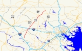
Maryland Route 27 is a state highway
in the central part of the U.S. state
of Maryland
.
. Despite signage at I-270
Exit 16, the route does not actually reach the Interstate.
The route runs north through Germantown and Damascus
, crossing Frederick
, Howard
and Carroll
counties into Mt. Airy
. Remaining in Carroll County, the route runs north, intersecting MD 26
in Taylorsville and eventually reaches Westminster
. After running through downtown Westminster and crossing MD 140
, the route continues north and ends in Manchester
at MD 30
.
|-
!County
!Location
!Mile
!Destinations
!Notes
|-
|rowspan=3|Montgomery
|Germantown
|0.00
|
|Southern terminus
|-
|rowspan=2|Damascus
|6.56
|
|MD 27 turns north at this intersection
|-
|8.75
|
|
|-
|Howard
|rowspan=6|Mount Airy
|
|
|No major intersections in Howard County.
|-
|Montgomery
|
|
|MD-27 re-enters Montgomery County briefly. No intersections.
|-
|Frederick
|11.76
|
|Officially MD 144A
|-
|rowspan=2|Frederick
/Carroll
|12.17
|
|I-70 Exit 68. MD-27 serves as the county line in this area.
|-
|12.39
|Main Street north to
|East leg of intersection is exit ramp from westbound I-70
|-
|rowspan=10|Carroll
|13.13
|Ridgeville Boulevard
|Old alignment of US 40
|-
|
|15.05
|
|Officially MD 808A
|-
|rowspan=2|Taylorsville
|20.65
|
|
|-
|22.73
|
|
|-
|rowspan=3|Westminster
|30.41
|Main Street
|Formerly part of MD 32
|-
|31.01
|
|Interchange
|-
|31.78
|Old Manchester Road north
|Unsigned MD 852G
|-
|rowspan=2|Mexico
|33.61
|
|
|-
|34.04
|Old Manchester Road south
|Unsigned MD 852G
|-
|Manchester
|39.17
|
|Northern terminus
 The route was originally designated Maryland Route 29 in 1933, with the original route of U.S. Route 29
via Ashton
being designated Maryland Route 27. After US 29's arrival in 1934, the two routes swapped numbers, with MD 29 becoming MD 27, and MD 27 becoming MD 29 (and thus being promoted to US 29 without conflict).
At one time, all of MD 27 north of Westminster, as well as a small piece of the former route northeast of Manchester, was part of MD 31
.
State highway
State highway, state road or state route can refer to one of three related concepts, two of them related to a state or provincial government in a country that is divided into states or provinces :#A...
in the central part of the U.S. state
U.S. state
A U.S. state is any one of the 50 federated states of the United States of America that share sovereignty with the federal government. Because of this shared sovereignty, an American is a citizen both of the federal entity and of his or her state of domicile. Four states use the official title of...
of Maryland
Maryland
Maryland is a U.S. state located in the Mid Atlantic region of the United States, bordering Virginia, West Virginia, and the District of Columbia to its south and west; Pennsylvania to its north; and Delaware to its east...
.
Route description
MD 27, also known as Ridge Road and Manchester Road (at Northern Point), begins in Germantown at MD 355Maryland Route 355
Maryland Route 355 is a north–south road in western central Maryland in the United States. The southern terminus of the route is at the Washington, D.C. border in Friendship Heights, Montgomery County, where it continues south as Wisconsin Avenue into Washington. The northern terminus is...
. Despite signage at I-270
Interstate 270 (Maryland)
Interstate 270 is a auxiliary Interstate Highway in the U.S. state of Maryland that travels between Interstate 495 just north of Bethesda, Montgomery County and Interstate 70 in the city of Frederick in Frederick County. It consists of the mainline as well as a spur that provides access to and...
Exit 16, the route does not actually reach the Interstate.
The route runs north through Germantown and Damascus
Damascus, Maryland
Damascus is a census-designated place and an unincorporated area in Montgomery County, Maryland, United States.In the early part of the 20th century, there was an incorporated municipality there for about a quarter century, but it no longer exists...
, crossing Frederick
Frederick County, Maryland
Frederick County is a county located in the western part of the U.S. state of Maryland, bordering the southern border of Pennsylvania and the northeastern border of Virginia. As of the 2010 Census, the population was 233,385....
, Howard
Howard County, Maryland
-2010:Whereas according to the 2010 U.S. Census Bureau:*62.2% White*17.5% Black*0.3% Native American*14.4% Asian*0.0% Native Hawaiian or Pacific Islander*3.6% Two or more races*2.0% Other races*5.8% Hispanic or Latino -2000:...
and Carroll
Carroll County, Maryland
Carroll County is a county located in the U.S. state of Maryland. In 2010, its population was 167,134. It was named for Charles Carroll of Carrollton , signer of the American Declaration of Independence. Its county seat is Westminster....
counties into Mt. Airy
Mount Airy, Maryland
Mount Airy is a town in Carroll, Frederick, Howard, and Montgomery counties in the U.S. state of Maryland.-Geography:According to the United States Census Bureau, the town has a total area of , all of it land.-History:...
. Remaining in Carroll County, the route runs north, intersecting MD 26
Maryland Route 26
Maryland Route 26 is an east–west state highway in the U.S. state of Maryland. Outside of the Baltimore city limits, it is known as Liberty Road; inside the city limits it is known as Liberty Heights Avenue....
in Taylorsville and eventually reaches Westminster
Westminster, Maryland
Westminster is a city in northern Maryland, United States. It is the seat of Carroll County. The city's population was 18,590 at the 2010 census. Westminster is an outlying community within the Baltimore-Towson, MD MSA, which is part of a greater Washington-Baltimore-Northern Virginia, DC-MD-VA-WV...
. After running through downtown Westminster and crossing MD 140
Maryland Route 140
Maryland Route 140 is a local long route in northern Maryland, United States.-Route description:MD 140 is known by various names depending on location; south of Reisterstown it is known as Reisterstown Road. Though Reisterstown itself is named after John Reister, the road is named after Jacob...
, the route continues north and ends in Manchester
Manchester, Maryland
Manchester, Maryland, is a small incorporated town in Northeastern Carroll County, Maryland located on the Eastern coast of the United States of America just South of the Pennsylvania State line and North of Baltimore, Maryland...
at MD 30
Maryland Route 30
Maryland Route 30 is a state highway in Central Maryland region in the U.S. state of Maryland. It serves as one of the major north–south routes of central Maryland.-Route description:...
.
Junction list
{| class=wikitable|-
!County
!Location
!Mile
!Destinations
!Notes
|-
|rowspan=3|Montgomery
Montgomery County, Maryland
Montgomery County is a county in the U.S. state of Maryland, situated just to the north of Washington, D.C., and southwest of the city of Baltimore. It is one of the most affluent counties in the United States, and has the highest percentage of residents over 25 years of age who hold post-graduate...
|Germantown
|0.00
|
|Southern terminus
|-
|rowspan=2|Damascus
Damascus, Maryland
Damascus is a census-designated place and an unincorporated area in Montgomery County, Maryland, United States.In the early part of the 20th century, there was an incorporated municipality there for about a quarter century, but it no longer exists...
|6.56
|
|MD 27 turns north at this intersection
|-
|8.75
|
|
|-
|Howard
Howard County, Maryland
-2010:Whereas according to the 2010 U.S. Census Bureau:*62.2% White*17.5% Black*0.3% Native American*14.4% Asian*0.0% Native Hawaiian or Pacific Islander*3.6% Two or more races*2.0% Other races*5.8% Hispanic or Latino -2000:...
|rowspan=6|Mount Airy
Mount Airy, Maryland
Mount Airy is a town in Carroll, Frederick, Howard, and Montgomery counties in the U.S. state of Maryland.-Geography:According to the United States Census Bureau, the town has a total area of , all of it land.-History:...
|
|
|No major intersections in Howard County.
|-
|Montgomery
Montgomery County, Maryland
Montgomery County is a county in the U.S. state of Maryland, situated just to the north of Washington, D.C., and southwest of the city of Baltimore. It is one of the most affluent counties in the United States, and has the highest percentage of residents over 25 years of age who hold post-graduate...
|
|
|MD-27 re-enters Montgomery County briefly. No intersections.
|-
|Frederick
Frederick County, Maryland
Frederick County is a county located in the western part of the U.S. state of Maryland, bordering the southern border of Pennsylvania and the northeastern border of Virginia. As of the 2010 Census, the population was 233,385....
|11.76
|
|Officially MD 144A
|-
|rowspan=2|Frederick
Frederick County, Maryland
Frederick County is a county located in the western part of the U.S. state of Maryland, bordering the southern border of Pennsylvania and the northeastern border of Virginia. As of the 2010 Census, the population was 233,385....
/Carroll
Carroll County, Maryland
Carroll County is a county located in the U.S. state of Maryland. In 2010, its population was 167,134. It was named for Charles Carroll of Carrollton , signer of the American Declaration of Independence. Its county seat is Westminster....
|12.17
|
|I-70 Exit 68. MD-27 serves as the county line in this area.
|-
|12.39
|Main Street north to
|East leg of intersection is exit ramp from westbound I-70
|-
|rowspan=10|Carroll
Carroll County, Maryland
Carroll County is a county located in the U.S. state of Maryland. In 2010, its population was 167,134. It was named for Charles Carroll of Carrollton , signer of the American Declaration of Independence. Its county seat is Westminster....
|13.13
|Ridgeville Boulevard
|Old alignment of US 40
|-
|
|15.05
|
|Officially MD 808A
|-
|rowspan=2|Taylorsville
|20.65
|
|
|-
|22.73
|
|
|-
|rowspan=3|Westminster
Westminster, Maryland
Westminster is a city in northern Maryland, United States. It is the seat of Carroll County. The city's population was 18,590 at the 2010 census. Westminster is an outlying community within the Baltimore-Towson, MD MSA, which is part of a greater Washington-Baltimore-Northern Virginia, DC-MD-VA-WV...
|30.41
|Main Street
|Formerly part of MD 32
Maryland Route 32
Maryland Route 32 is a state highway in the U.S. state of Maryland. The state highway runs from Interstate 97 and MD 3 in Millersville west and north to Washington Road in Westminster. The east–west portion of MD 32 is the Patuxent Freeway, a four- to six-lane...
|-
|31.01
|
|Interchange
|-
|31.78
|Old Manchester Road north
|Unsigned MD 852G
Maryland Route 852
Maryland Route 852 is a collection of state highways in the U.S. state of Maryland. These highways are service roads related to and sections of an old alignment of MD 31 between New Windsor and Manchester in Carroll County. Between Westminster and Manchester, the sections of MD 852 follow MD 27,...
|-
|rowspan=2|Mexico
Mexico, Carroll County, Maryland
Mexico is an unincorporated community in Carroll County, Maryland. It lies at an elevation of 968 feet ....
|33.61
|
|
|-
|34.04
|Old Manchester Road south
|Unsigned MD 852G
Maryland Route 852
Maryland Route 852 is a collection of state highways in the U.S. state of Maryland. These highways are service roads related to and sections of an old alignment of MD 31 between New Windsor and Manchester in Carroll County. Between Westminster and Manchester, the sections of MD 852 follow MD 27,...
|-
|Manchester
Manchester, Maryland
Manchester, Maryland, is a small incorporated town in Northeastern Carroll County, Maryland located on the Eastern coast of the United States of America just South of the Pennsylvania State line and North of Baltimore, Maryland...
|39.17
|
|Northern terminus
History
U.S. Route 29
U.S. Route 29 is a north–south United States highway that runs for from the western suburbs of Baltimore, Maryland, to Pensacola, Florida. This highway's northern terminus is at Maryland Route 99 in Ellicott City, Maryland...
via Ashton
Ashton, Maryland
Ashton is an unincorporated area in Montgomery County, Maryland. The commercial center of Ashton lies at the junction of Route 108 and New Hampshire Avenue ....
being designated Maryland Route 27. After US 29's arrival in 1934, the two routes swapped numbers, with MD 29 becoming MD 27, and MD 27 becoming MD 29 (and thus being promoted to US 29 without conflict).
At one time, all of MD 27 north of Westminster, as well as a small piece of the former route northeast of Manchester, was part of MD 31
Maryland Route 31
Maryland Route 31 is a state highway in the U.S. state of Maryland. Known for most of its length as New Windsor Road, the state highway runs from MD 26 in Libertytown east to MD 140 in Westminster. MD 31 connects the county seats of Frederick and Westminster via Libertytown in eastern Frederick...
.