
Florida Canal
Encyclopedia
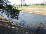
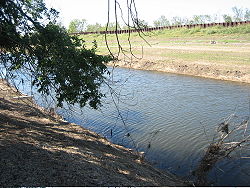
The Florida Canal or 40 Arpent Canal is a canal
in the New Orleans metropolitan area
and land down river.
 The canal was built in the 18th century colonial era of Louisiana, stretching from what is now the Faubourg Marigny
neighborhood of New Orleans
, roughly paralleling the Mississippi River
on the East Bank down through modern Saint Bernard Parish and part of the East Bank of Plaquemines
. Colonial land grants commonly stretched 40 arpent
s back from the Mississippi River. The canal thus marked the back end of properties, mostly originally plantation
s. In this area this line happened to generally be about the limit of land useful for cultivation where the higher land of the natural river levee
ended in swamp
. The "40 Arpent Canal" was used by small vessels for commerce between nearby plantations; larger vessels and longer range shipping used the Mississippi. The earth moved to dig the canal was used to create a raised roadway on the river side of the canal, called the "Florida Walk".
With development and the construction of additional perpendicular canals in the 19th and 20th century, the old 40 Arpent Canal was divided into several discontinuous canals. Florida Walk became Florida Avenue, although discontinued in some areas either by being developed over or being allowed to fall back into wilderness. In some places such as New Orleans the remaining pieces of the canal became known as the "Florida Canal", while in parts of Saint Bernard and Plaquemines the old "40 Arpent Canal" name is still used. No longer used for shipping, the canal is still used for drainage
, and in places some small pleasure and fishing boats.
Down river from the Industrial Canal
, the Florida Canal still marks the inland boundary of the Lower 9th Ward neighborhood of New Orleans and communities such as Arabi
and Chalmette
.
Levee
s and floodwalls constructed on the back side of the canal help protect settled areas from flooding. These levees in back of the canal were overtopped by storm surge
s during Hurricane Katrina
in 2005; to do this the storm surge needed to first top the larger levees abutting the MR-GO and travel through the wetlands between MR-GO and the 40 Arpent Canal back levee. In December 2005 it was announced that in Saint Bernard Parish the 40 Arpent Canal back levee would be increased in height to help offer some temporary protection until more comprehensive work could be done on MR-GO.
Canal
Canals are man-made channels for water. There are two types of canal:#Waterways: navigable transportation canals used for carrying ships and boats shipping goods and conveying people, further subdivided into two kinds:...
in the New Orleans metropolitan area
New Orleans metropolitan area
New Orleans–Metairie–Kenner, or the Greater New Orleans Region is a metropolitan area designated by the United States Census encompassing seven parishes in the state of Louisiana, centering on the city of New Orleans...
and land down river.
Faubourg Marigny
The Marigny is a neighborhood of the city of New Orleans. A subdistrict of the Bywater District Area, its boundaries as defined by the City Planning Commission are: North Rampart Street and St...
neighborhood of New Orleans
New Orleans, Louisiana
New Orleans is a major United States port and the largest city and metropolitan area in the state of Louisiana. The New Orleans metropolitan area has a population of 1,235,650 as of 2009, the 46th largest in the USA. The New Orleans – Metairie – Bogalusa combined statistical area has a population...
, roughly paralleling the Mississippi River
Mississippi River
The Mississippi River is the largest river system in North America. Flowing entirely in the United States, this river rises in western Minnesota and meanders slowly southwards for to the Mississippi River Delta at the Gulf of Mexico. With its many tributaries, the Mississippi's watershed drains...
on the East Bank down through modern Saint Bernard Parish and part of the East Bank of Plaquemines
Plaquemines Parish, Louisiana
Plaquemines Parish is the parish with the most combined land and water area in the U.S. state of Louisiana. The parish seat is Pointe à la Hache...
. Colonial land grants commonly stretched 40 arpent
Arpent
An arpent is a unit of length and a unit of area. It is a pre-metric French unit based on the Roman actus. It is used in Quebec as well as in some areas of the United States that were part of French Louisiana.-Unit of length:...
s back from the Mississippi River. The canal thus marked the back end of properties, mostly originally plantation
Plantation
A plantation is a long artificially established forest, farm or estate, where crops are grown for sale, often in distant markets rather than for local on-site consumption...
s. In this area this line happened to generally be about the limit of land useful for cultivation where the higher land of the natural river levee
Levee
A levee, levée, dike , embankment, floodbank or stopbank is an elongated naturally occurring ridge or artificially constructed fill or wall, which regulates water levels...
ended in swamp
Swamp
A swamp is a wetland with some flooding of large areas of land by shallow bodies of water. A swamp generally has a large number of hammocks, or dry-land protrusions, covered by aquatic vegetation, or vegetation that tolerates periodical inundation. The two main types of swamp are "true" or swamp...
. The "40 Arpent Canal" was used by small vessels for commerce between nearby plantations; larger vessels and longer range shipping used the Mississippi. The earth moved to dig the canal was used to create a raised roadway on the river side of the canal, called the "Florida Walk".
With development and the construction of additional perpendicular canals in the 19th and 20th century, the old 40 Arpent Canal was divided into several discontinuous canals. Florida Walk became Florida Avenue, although discontinued in some areas either by being developed over or being allowed to fall back into wilderness. In some places such as New Orleans the remaining pieces of the canal became known as the "Florida Canal", while in parts of Saint Bernard and Plaquemines the old "40 Arpent Canal" name is still used. No longer used for shipping, the canal is still used for drainage
Drainage
Drainage is the natural or artificial removal of surface and sub-surface water from an area. Many agricultural soils need drainage to improve production or to manage water supplies.-Early history:...
, and in places some small pleasure and fishing boats.
Down river from the Industrial Canal
Industrial Canal
The Industrial Canal is a 5.5 mile waterway in New Orleans, Louisiana, United States. The waterway's proper name, as used by the U.S. Army Corps of Engineers and on NOAA nautical charts, is Inner Harbor Navigation Canal...
, the Florida Canal still marks the inland boundary of the Lower 9th Ward neighborhood of New Orleans and communities such as Arabi
Arabi, Louisiana
Arabi is a census-designated place in St. Bernard Parish, Louisiana on the East Bank of the Mississippi River, between the Lower 9th Ward of New Orleans, Louisiana and Chalmette within the Greater New Orleans Metropolitan area...
and Chalmette
Chalmette, Louisiana
Chalmette is a census-designated place in and the parish seat of St. Bernard Parish, Louisiana, United States. The population was 32,069 at the 2000 census. It is part of the New Orleans–Metairie–Kenner Metropolitan Statistical Area...
.
Levee
Levee
A levee, levée, dike , embankment, floodbank or stopbank is an elongated naturally occurring ridge or artificially constructed fill or wall, which regulates water levels...
s and floodwalls constructed on the back side of the canal help protect settled areas from flooding. These levees in back of the canal were overtopped by storm surge
Storm surge
A storm surge is an offshore rise of water associated with a low pressure weather system, typically tropical cyclones and strong extratropical cyclones. Storm surges are caused primarily by high winds pushing on the ocean's surface. The wind causes the water to pile up higher than the ordinary sea...
s during Hurricane Katrina
Hurricane Katrina
Hurricane Katrina of the 2005 Atlantic hurricane season was a powerful Atlantic hurricane. It is the costliest natural disaster, as well as one of the five deadliest hurricanes, in the history of the United States. Among recorded Atlantic hurricanes, it was the sixth strongest overall...
in 2005; to do this the storm surge needed to first top the larger levees abutting the MR-GO and travel through the wetlands between MR-GO and the 40 Arpent Canal back levee. In December 2005 it was announced that in Saint Bernard Parish the 40 Arpent Canal back levee would be increased in height to help offer some temporary protection until more comprehensive work could be done on MR-GO.