

Butt of Lewis
Encyclopedia
| valign="top" | |
Outer Hebrides
The Outer Hebrides also known as the Western Isles and the Long Island, is an island chain off the west coast of Scotland. The islands are geographically contiguous with Comhairle nan Eilean Siar, one of the 32 unitary council areas of Scotland...
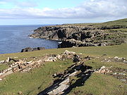
. The headland
Headland
A headland is a point of land, usually high and often with a sheer drop, that extends out into a body of water.Headland can also refer to:*Headlands and bays*headLand, an Australian television series...
, which lies in the North Atlantic, is frequently battered by heavy swells and storms.
Lighthouse
A lighthouseLighthouse
A lighthouse is a tower, building, or other type of structure designed to emit light from a system of lamps and lenses or, in older times, from a fire, and used as an aid to navigation for maritime pilots at sea or on inland waterways....
, which was designed by David Stevenson
David Stevenson (engineer)
David Stevenson FRSE FRSSA was a Scottish lighthouse designer, who designed over thirty lighthouses in and around Scotland, and helped found a great dynasty of lighthouse engineering.-Background:...
, was built on Butt of Lewis to aid shipping in the 1860s. The station is now completely automated. The nearest urban areas are in Ness about 2 miles to the south.
A modern differential GPS
Differential GPS
Differential Global Positioning System is an enhancement to Global Positioning System that provides improved location accuracy, from the 15-meter nominal GPS accuracy to about 10 cm in case of the best implementations....
base station has now been sited on a nearby hill to further aid navigation. This hill was also the site for a Lloyd's Signal Station from the 1890's.
The road to the lighthouse passes a sheltered cove called Port Stoth
Port Stoth
Port Stoth known locally as Stoth is a sheltered inlet just south east of the Butt of Lewis in the Outer Hebrides, Scotland. It is the most northerly landing in the Outer Hebrides...
. Agricultural lazy bed
Lazy bed
Lazy bed is a method of arable cultivation. Rather like cord rig cultivation, parallel banks of ridge and furrow are dug by spade although lazy beds have banks that are bigger, up to 2.5m in width, with narrow drainage channels between them....
s are also visible along the coast. The Butt of Lewis features some of the oldest rocks in Europe, having been formed in the Precambrian
Precambrian
The Precambrian is the name which describes the large span of time in Earth's history before the current Phanerozoic Eon, and is a Supereon divided into several eons of the geologic time scale...
period up to 3000 million years ago. Following the coast south west from the lighthouse there is a natural arch
Natural arch
A natural arch or natural bridge is a natural geological formation where a rock arch forms, with an opening underneath. Most natural arches form as a narrow ridge, walled by cliffs, become narrower from erosion, with a softer rock stratum under the cliff-forming stratum gradually eroding out until...
called the "Eye of the Butt" . It can be best viewed from the Habost
Habost
Habost is the name of two crofting townships on the Isle of Lewis in the Outer Hebrides of Scotland.One is in the Ness area at the northern tip of the island at and is home to an arts and music centre....
machair.