
Hirta
Encyclopedia
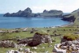
Hirta is the largest island in the St Kilda
archipelago, on the western edge of Scotland
. The name "Hiort" (in Scottish Gaelic) and "Hirta" (historically in English) have also been applied to the entire archipelago.
ers can also land for a break on a small boulder beach backed by cliffs in the north of the island, just before the north-east side where the highest summit in the island, Conachair, forms a precipice 430 m (1,410.8 ft). St Kilda is probably the core of a Tertiary
volcano
, but, besides volcanic rocks, it contains hills of sandstone
in which the stratification
is distinct.
Dùn
is separated from Hirta by a shallow strait about 50 metres (54.7 yd) wide. This is normally impassable but is reputed to dry out on rare occasions.
Viking burials have been found there. St. Kilda was part of the Lordship of the Isles, then a property of the MacLeods of Dunvegan from 1498 until 1930. There were three chapels on St. Kilda, dedicated to St Brendan, St Columba, and Christ Church, but little remains. There are also the remains of a beehive house, known as the 'Amazon's House'.
The islanders had a tough life, and survived by exploiting the thousands of sea birds which live on the islands. There are a large number of 'cleits', huts used for storing dried sea birds, fish, hay and turf. The islanders had a very democratic system, and decisions were taken by an island council, made up of all the menfolk. The present village was set out in the 1830s above village bay, but in the 1880s some of the population left for Australia, and the remaining inhabitants were finally evacuated in the 1930s because of hardship and storms which had cut off the islands for weeks.
The island was bequeathed to The National Trust for Scotland in 1957 and was designated as Scotland's first World Heritage Site in 1987. It is possible to visit the island. The Ministry of Defence established a base on Hirta for tracking missiles fired from the station on South Uist.
There are also various large stacks in the narrow strait between Hirta and Soay
- Stac Dona, Stac Soay and Stac Biorach
.
.
St Kilda, Scotland
St Kilda is an isolated archipelago west-northwest of North Uist in the North Atlantic Ocean. It contains the westernmost islands of the Outer Hebrides of Scotland. The largest island is Hirta, whose sea cliffs are the highest in the United Kingdom and three other islands , were also used for...
archipelago, on the western edge of Scotland
Scotland
Scotland is a country that is part of the United Kingdom. Occupying the northern third of the island of Great Britain, it shares a border with England to the south and is bounded by the North Sea to the east, the Atlantic Ocean to the north and west, and the North Channel and Irish Sea to the...
. The name "Hiort" (in Scottish Gaelic) and "Hirta" (historically in English) have also been applied to the entire archipelago.
Geography
The island measures 3.4 kilometres (2.11 mi) from east to west, and 3.3 kilometres (2.05 mi) from north to south. It has an area of 6.285 square kilometres (2.4 sq mi) and about 15 km (9.3 mi) of coastline. The only real landing place is in the shelter of Village Bay on the south-east side of the island. The island also slopes gently down to the sea at Glen Bay (at the western end of the north coast), but the rocks go straight into the sea at a shallow angle and landing here is not easy if there is any swell at all. Apart from these two places, the cliffs rise sheer out of deep water. However, sea kayakKayak
A kayak is a small, relatively narrow, human-powered boat primarily designed to be manually propelled by means of a double blade paddle.The traditional kayak has a covered deck and one or more cockpits, each seating one paddler...
ers can also land for a break on a small boulder beach backed by cliffs in the north of the island, just before the north-east side where the highest summit in the island, Conachair, forms a precipice 430 m (1,410.8 ft). St Kilda is probably the core of a Tertiary
Tertiary
The Tertiary is a deprecated term for a geologic period 65 million to 2.6 million years ago. The Tertiary covered the time span between the superseded Secondary period and the Quaternary...
volcano
Volcano
2. Bedrock3. Conduit 4. Base5. Sill6. Dike7. Layers of ash emitted by the volcano8. Flank| 9. Layers of lava emitted by the volcano10. Throat11. Parasitic cone12. Lava flow13. Vent14. Crater15...
, but, besides volcanic rocks, it contains hills of sandstone
Sandstone
Sandstone is a sedimentary rock composed mainly of sand-sized minerals or rock grains.Most sandstone is composed of quartz and/or feldspar because these are the most common minerals in the Earth's crust. Like sand, sandstone may be any colour, but the most common colours are tan, brown, yellow,...
in which the stratification
Stratum
In geology and related fields, a stratum is a layer of sedimentary rock or soil with internally consistent characteristics that distinguish it from other layers...
is distinct.
Dùn
Dùn, St Kilda
Dùn is an island in the St Kilda archipelago. It is nearly a mile long. Its name simply means "fort" in Scottish Gaelic , but the fort itself has been lost - old maps show it on Gob an Dùin , which is at the seaward end.Almost joined to Hirta at Ruiaval, the two islands are separated by Caolas an...
is separated from Hirta by a shallow strait about 50 metres (54.7 yd) wide. This is normally impassable but is reputed to dry out on rare occasions.
Population
Although the islands had been continuously populated since prehistoric times, the original inhabitants were evacuated in 1930, due to disease and outside influences.Viking burials have been found there. St. Kilda was part of the Lordship of the Isles, then a property of the MacLeods of Dunvegan from 1498 until 1930. There were three chapels on St. Kilda, dedicated to St Brendan, St Columba, and Christ Church, but little remains. There are also the remains of a beehive house, known as the 'Amazon's House'.
The islanders had a tough life, and survived by exploiting the thousands of sea birds which live on the islands. There are a large number of 'cleits', huts used for storing dried sea birds, fish, hay and turf. The islanders had a very democratic system, and decisions were taken by an island council, made up of all the menfolk. The present village was set out in the 1830s above village bay, but in the 1880s some of the population left for Australia, and the remaining inhabitants were finally evacuated in the 1930s because of hardship and storms which had cut off the islands for weeks.
The island was bequeathed to The National Trust for Scotland in 1957 and was designated as Scotland's first World Heritage Site in 1987. It is possible to visit the island. The Ministry of Defence established a base on Hirta for tracking missiles fired from the station on South Uist.
Surrounding stacks
Hirta is surrounded by a number of small stacks. Bradastac, Mina Stac and Sgeir Domhnuill lie under the cliffs of Conachair to the east and Sgeir nan Sgarbh further south under the heights of Osieval. An Torc is west of Ruabhal and Sgeir Mhòr is further north under Mullach Bi.There are also various large stacks in the narrow strait between Hirta and Soay
Soay, St Kilda
Soay is an uninhabited islet in the St Kilda archipelago, Scotland. The island is part of the St Kilda World Heritage Site and home to a primitive breed of sheep...
- Stac Dona, Stac Soay and Stac Biorach
Stac Biorach
Stac Biorach is a sea stack, 73 metres tall, situated between Hirta and Soay in the St Kilda archipelago of Scotland...
.
See also
- St Kilda, ScotlandSt Kilda, ScotlandSt Kilda is an isolated archipelago west-northwest of North Uist in the North Atlantic Ocean. It contains the westernmost islands of the Outer Hebrides of Scotland. The largest island is Hirta, whose sea cliffs are the highest in the United Kingdom and three other islands , were also used for...
- detailed article on the archipelago - List of outlying islands of Scotland
External links
refers to life on Hirta, although it was actually shot on FoulaFoula
Foula in the Shetland Islands of Scotland is one of Great Britain’s most remote permanently inhabited islands. Owned since the turn of the 20th century by the Holbourn family, the island was the location for the film The Edge of the World...
.