

List of Ultras in Central America
Encyclopedia
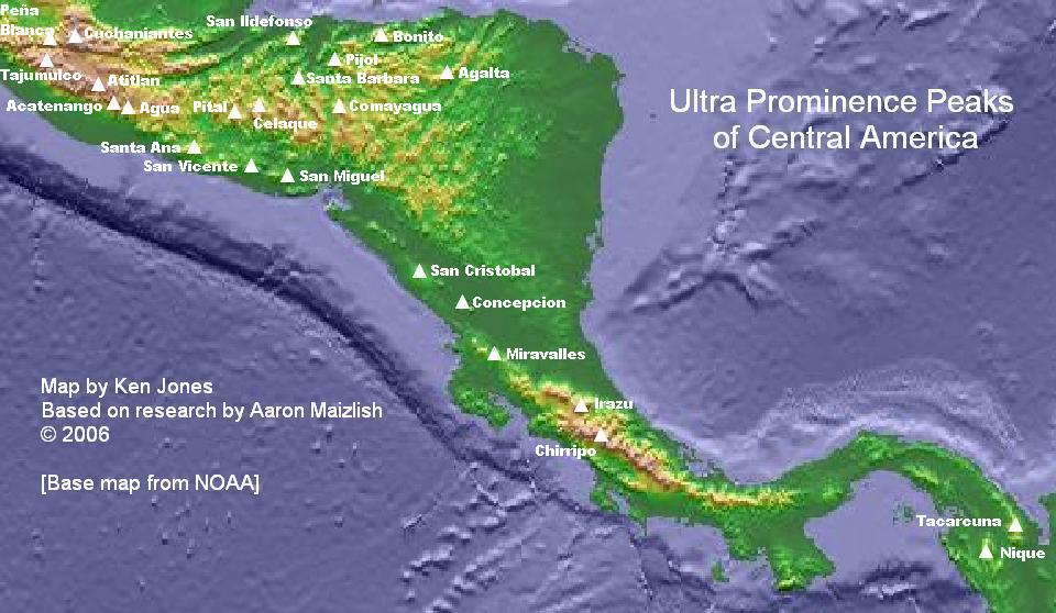
The following is a sortable table of the 23 ultra-prominent mountain peaks of Central America
. This article defines Central America as the seven nations of Belize
, Costa Rica
, El Salvador
, Guatemala
, Honduras
, Nicaragua
, and Panama
.
Topographic elevation is the vertical distance above the reference geoid
, a precise mathematical model of the Earth's
sea level
as an equipotential
gravitational surface
. Topographic prominence
is the elevation difference between the summit
and the highest or key col to a higher summit. Topographic isolation
is the minimum great circle
distance to a point of higher elevation.
This article defines a significant summit as a summit with at least 100 meters (328.1 feet) of topographic prominence, and a major summit as a summit with at least 500 meters (1640.4 feet) of topographic prominence. An ultra-prominent summit is a summit with at least 1500 meters (4921.3 feet) of topographic prominence.
Of these 23 ultra-prominent summits of Central America, 7 are located in Guatemala
, 7 in Honduras
, 4 in El Salvador
, 3 in Costa Rica
, 2 in Nicaragua
, and 1 in Panama
. Volcán Tacaná
lies on the international border between Guatemala
and México
, and Cerro El Pital
straddles the border between Honduras
and El Salvador
.
Central America
Central America is the central geographic region of the Americas. It is the southernmost, isthmian portion of the North American continent, which connects with South America on the southeast. When considered part of the unified continental model, it is considered a subcontinent...
. This article defines Central America as the seven nations of Belize
Belize
Belize is a constitutional monarchy and the northernmost country in Central America. Belize has a diverse society, comprising many cultures and languages. Even though Kriol and Spanish are spoken among the population, Belize is the only country in Central America where English is the official...
, Costa Rica
Costa Rica
Costa Rica , officially the Republic of Costa Rica is a multilingual, multiethnic and multicultural country in Central America, bordered by Nicaragua to the north, Panama to the southeast, the Pacific Ocean to the west and the Caribbean Sea to the east....
, El Salvador
El Salvador
El Salvador or simply Salvador is the smallest and the most densely populated country in Central America. The country's capital city and largest city is San Salvador; Santa Ana and San Miguel are also important cultural and commercial centers in the country and in all of Central America...
, Guatemala
Guatemala
Guatemala is a country in Central America bordered by Mexico to the north and west, the Pacific Ocean to the southwest, Belize to the northeast, the Caribbean to the east, and Honduras and El Salvador to the southeast...
, Honduras
Honduras
Honduras is a republic in Central America. It was previously known as Spanish Honduras to differentiate it from British Honduras, which became the modern-day state of Belize...
, Nicaragua
Nicaragua
Nicaragua is the largest country in the Central American American isthmus, bordered by Honduras to the north and Costa Rica to the south. The country is situated between 11 and 14 degrees north of the Equator in the Northern Hemisphere, which places it entirely within the tropics. The Pacific Ocean...
, and Panama
Panama
Panama , officially the Republic of Panama , is the southernmost country of Central America. Situated on the isthmus connecting North and South America, it is bordered by Costa Rica to the northwest, Colombia to the southeast, the Caribbean Sea to the north and the Pacific Ocean to the south. The...
.
Topographic elevation is the vertical distance above the reference geoid
Geoid
The geoid is that equipotential surface which would coincide exactly with the mean ocean surface of the Earth, if the oceans were in equilibrium, at rest , and extended through the continents . According to C.F...
, a precise mathematical model of the Earth's
Earth
Earth is the third planet from the Sun, and the densest and fifth-largest of the eight planets in the Solar System. It is also the largest of the Solar System's four terrestrial planets...
sea level
Sea level
Mean sea level is a measure of the average height of the ocean's surface ; used as a standard in reckoning land elevation...
as an equipotential
Equipotential
Equipotential or isopotential in mathematics and physics refers to a region in space where every point in it is at the same potential. This usually refers to a scalar potential , although it can also be applied to vector potentials...
gravitational surface
Surface
In mathematics, specifically in topology, a surface is a two-dimensional topological manifold. The most familiar examples are those that arise as the boundaries of solid objects in ordinary three-dimensional Euclidean space R3 — for example, the surface of a ball...
. Topographic prominence
Topographic prominence
In topography, prominence, also known as autonomous height, relative height, shoulder drop , or prime factor , categorizes the height of the mountain's or hill's summit by the elevation between it and the lowest contour line encircling it and no higher summit...
is the elevation difference between the summit
Summit (topography)
In topography, a summit is a point on a surface that is higher in elevation than all points immediately adjacent to it. Mathematically, a summit is a local maximum in elevation...
and the highest or key col to a higher summit. Topographic isolation
Topographic isolation
The topographic isolation of a summit is the minimum horizontal distance to the nearest point of higher elevation. Topographic isolation represents a radius of dominance in which the summit is the highest point. Topographic isolation can be calculated for small hills and islands as well as for...
is the minimum great circle
Great circle
A great circle, also known as a Riemannian circle, of a sphere is the intersection of the sphere and a plane which passes through the center point of the sphere, as opposed to a general circle of a sphere where the plane is not required to pass through the center...
distance to a point of higher elevation.
This article defines a significant summit as a summit with at least 100 meters (328.1 feet) of topographic prominence, and a major summit as a summit with at least 500 meters (1640.4 feet) of topographic prominence. An ultra-prominent summit is a summit with at least 1500 meters (4921.3 feet) of topographic prominence.
Of these 23 ultra-prominent summits of Central America, 7 are located in Guatemala
Guatemala
Guatemala is a country in Central America bordered by Mexico to the north and west, the Pacific Ocean to the southwest, Belize to the northeast, the Caribbean to the east, and Honduras and El Salvador to the southeast...
, 7 in Honduras
Honduras
Honduras is a republic in Central America. It was previously known as Spanish Honduras to differentiate it from British Honduras, which became the modern-day state of Belize...
, 4 in El Salvador
El Salvador
El Salvador or simply Salvador is the smallest and the most densely populated country in Central America. The country's capital city and largest city is San Salvador; Santa Ana and San Miguel are also important cultural and commercial centers in the country and in all of Central America...
, 3 in Costa Rica
Costa Rica
Costa Rica , officially the Republic of Costa Rica is a multilingual, multiethnic and multicultural country in Central America, bordered by Nicaragua to the north, Panama to the southeast, the Pacific Ocean to the west and the Caribbean Sea to the east....
, 2 in Nicaragua
Nicaragua
Nicaragua is the largest country in the Central American American isthmus, bordered by Honduras to the north and Costa Rica to the south. The country is situated between 11 and 14 degrees north of the Equator in the Northern Hemisphere, which places it entirely within the tropics. The Pacific Ocean...
, and 1 in Panama
Panama
Panama , officially the Republic of Panama , is the southernmost country of Central America. Situated on the isthmus connecting North and South America, it is bordered by Costa Rica to the northwest, Colombia to the southeast, the Caribbean Sea to the north and the Pacific Ocean to the south. The...
. Volcán Tacaná
Volcán Tacaná
The Tacaná Volcano is the second highest peak in Central America at . It is located in the Tacaná municipality of the Guatemalan department of San Marcos, and in Cacahoatán Municipality and Unión Juárez Municipality in the Mexican state of Chiapas....
lies on the international border between Guatemala
Guatemala
Guatemala is a country in Central America bordered by Mexico to the north and west, the Pacific Ocean to the southwest, Belize to the northeast, the Caribbean to the east, and Honduras and El Salvador to the southeast...
and México
Mexico
The United Mexican States , commonly known as Mexico , is a federal constitutional republic in North America. It is bordered on the north by the United States; on the south and west by the Pacific Ocean; on the southeast by Guatemala, Belize, and the Caribbean Sea; and on the east by the Gulf of...
, and Cerro El Pital
Cerro El Pital
Cerro El Pital is a mountain in Central America, on the border of El Salvador and Honduras. It is located from the town of La Palma and at a height of it is the highest point of the Salvadoran territory...
straddles the border between Honduras
Honduras
Honduras is a republic in Central America. It was previously known as Spanish Honduras to differentiate it from British Honduras, which became the modern-day state of Belize...
and El Salvador
El Salvador
El Salvador or simply Salvador is the smallest and the most densely populated country in Central America. The country's capital city and largest city is San Salvador; Santa Ana and San Miguel are also important cultural and commercial centers in the country and in all of Central America...
.
Most prominent summits
| Rank Ranking A ranking is a relationship between a set of items such that, for any two items, the first is either 'ranked higher than', 'ranked lower than' or 'ranked equal to' the second.... |
Mountain Peak Summit (topography) In topography, a summit is a point on a surface that is higher in elevation than all points immediately adjacent to it. Mathematically, a summit is a local maximum in elevation... |
Country | Province Province A province is a territorial unit, almost always an administrative division, within a country or state.-Etymology:The English word "province" is attested since about 1330 and derives from the 13th-century Old French "province," which itself comes from the Latin word "provincia," which referred to... |
Elevation | Prominence Topographic prominence In topography, prominence, also known as autonomous height, relative height, shoulder drop , or prime factor , categorizes the height of the mountain's or hill's summit by the elevation between it and the lowest contour line encircling it and no higher summit... |
Isolation Topographic isolation The topographic isolation of a summit is the minimum horizontal distance to the nearest point of higher elevation. Topographic isolation represents a radius of dominance in which the summit is the highest point. Topographic isolation can be calculated for small hills and islands as well as for... |
|---|---|---|---|
| 1 | Volcán Tajumulco Volcán Tajumulco Volcán Tajumulco is a large stratovolcano in the department of San Marcos in western Guatemala. It is the highest mountain in Guatemala and Central America at... |
San Marcos |
|
| 2 | Chirripó Grande | Cartago Cartago Province Cartago is a province of Costa Rica. It is located in the central part of the country. Bordering provinces are Limón to the east and San José to the west. The capital is Cartago and it was formerly the capital city of Costa Rica until 1823 when the capital was changed to San Jose... Limón Limón Province Limón is one of seven provinces in Costa Rica. The majority of its territory is situated in the country's Caribbean lowlands, though the southwestern portion houses part of an extensive mountain range known as the Cordillera de Talamanca... San José San José Province San José is a province of Costa Rica. It is located in the central part of the country, and borders the provinces of Alajuela, Heredia, Cartago, Limón and Puntarenas. The provincial capital is San José. The province covers an area of 4,965.9 km²... |
|
| 3 | Volcán Tacaná Volcán Tacaná The Tacaná Volcano is the second highest peak in Central America at . It is located in the Tacaná municipality of the Guatemalan department of San Marcos, and in Cacahoatán Municipality and Unión Juárez Municipality in the Mexican state of Chiapas.... |
San Marcos Chiapas Chiapas Chiapas officially Estado Libre y Soberano de Chiapas is one of the 31 states that, with the Federal District, comprise the 32 Federal Entities of Mexico. It is divided in 118 municipalities and its capital city is Tuxtla Gutierrez. Other important cites in Chiapas include San Cristóbal de las... |
|
| 4 | Montaña de Santa Bárbara | Santa Bárbara |
|
| 5 | Cerro las Minas Cerro Las Minas Cerro Las Minas is the highest mountain in Honduras. Cerro Las Minas is located in the rugged and relatively isolated Lempira department in the western part of the country... |
Lempira |
|
| 6 | Volcán de Agua Volcán de Agua Volcán de Agua is a stratovolcano located in the department of Sacatepéquez in Guatemala. It has been inactive since the mid 16th century. At 3,760 metres, Agua Volcano towers more than 3,500 metres above the Pacific coastal plain to the south and 2,000 metres above the Guatemalan... |
Escuintla Sacatepéquez |
|
| 7 | Alto Cuchumatanes | Huehuetenango |
|
| 8 | Volcán Irazú | Cartago Cartago Province Cartago is a province of Costa Rica. It is located in the central part of the country. Bordering provinces are Limón to the east and San José to the west. The capital is Cartago and it was formerly the capital city of Costa Rica until 1823 when the capital was changed to San Jose... San José San José Province San José is a province of Costa Rica. It is located in the central part of the country, and borders the provinces of Alajuela, Heredia, Cartago, Limón and Puntarenas. The provincial capital is San José. The province covers an area of 4,965.9 km²... |
|
| 9 | Montañas Peña Blanca High Point | Huehuetenango |
|
| 10 | Volcán Acatenango | Chimaltenango Sacatepéquez |
|
| 11 | Volcán San Miguel | San Miguel San Miguel Department (El Salvador) San Miguel is a department of El Salvador in the eastern part of the country. The capital is San Miguel. It has 2,077 km² and a population of over 450,000... |
|
| 12 | Cerro Tacarcuna | Darién Darién Province Darién is a province in eastern Panama. It is also the largest province in Panama. It is hot, humid, heavily forested, and sparsely populated, having 48,378 habitants... |
|
| 13 | Volcán Atitlán Volcán Atitlán Volcán Atitlán is a large, conical, active stratovolcano adjacent to the caldera of Lake Atitlán in the Highlands of Guatemala. The volcano has been quite active historically, with more than a dozen eruptions recorded between 1469 and 1853, the date of its most recent eruption. Atitlán is part of... |
Sololá |
|
| 14 | Pico Bonito Pico Bonito Pico Bonito National Park is located on the north coast of Honduras, in the mountain range called Cordillera Nombre de Dios, to the southwest of the city La Ceiba. It is part of the Mesoamerican Biological Corridor .... |
Atlántida |
|
| 15 | Montaña San Ildefonso | Cortés |
|
| 16 | Volcán San Cristóbal | Chinandega |
|
| 17 | Volcán de Santa Ana | Santa Ana Santa Ana Department Santa Ana is a department of El Salvador in the northwest of the country. The capital is Santa Ana.- General information :It has 2,023 km² and a population of over 600,000. This department was created on February 8, 1855... Sonsonate Sonsonate Department Sonsonate is a department of El Salvador in the western part of the country. The capital is Sonsonate.The department has a population of over 500,000 and an area of 1,226 km².Created on June 12, 1824... |
|
| 18 | Volcán Concepción | Rivas |
|
| 19 | Pico Pijol | Yoro |
|
| 20 | Volcán de San Vicente | La Paz La Paz Department (El Salvador) La Paz is a department of El Salvador in the south central area of the country. The capital is Zacatecoluca. La Paz has an area of 1,224 km² and a population of more than 300,000. The department was created in 1852. There are various caves containing rock writing. The department has a church... San Vicente San Vicente Department San Vicente is a department of El Salvador in the center of the country. The capital is San Vicente. On October 4, 1834, San Vicente City of Austria and Lorenzana was made the capital of State of El Salvador during the Federal Republic of Central America... |
|
| 21 | Volcán Miravalles | Alajuela Alajuela Province Alajuela is a province of Costa Rica. It is located in the north-central part of the country, bordering Nicaragua to the north, and clockwise the provinces Heredia, San José, Puntarenas and Guanacaste... Guanacaste Guanacaste Province Guanacaste is a province of Costa Rica located in the northwestern part of the country, along the coast of the Pacific Ocean. To the north it borders Nicaragua. To the east is the Alajuela Province, and to the southeast is the Puntarenas Province. It is the most sparsely populated of all the... |
|
| 22 | Cerro el Pital Cerro El Pital Cerro El Pital is a mountain in Central America, on the border of El Salvador and Honduras. It is located from the town of La Palma and at a height of it is the highest point of the Salvadoran territory... |
Chalatenango Chalatenango Department Chalatenango is a department of El Salvador, located in the northwest of the country. The capital is the city of Chalatenango. The Chalatenango Department encompasses 2,017 km² and contains more than 220,000 inhabitants. Las Matras Archaeological Ruins contains the relics of prehistoric... Ocotepeque |
|
| 23 | Montaña los Comayagua | Comayagua |
|
See also
- Central AmericaCentral AmericaCentral America is the central geographic region of the Americas. It is the southernmost, isthmian portion of the North American continent, which connects with South America on the southeast. When considered part of the unified continental model, it is considered a subcontinent...
- BelizeBelizeBelize is a constitutional monarchy and the northernmost country in Central America. Belize has a diverse society, comprising many cultures and languages. Even though Kriol and Spanish are spoken among the population, Belize is the only country in Central America where English is the official...
- Costa RicaCosta RicaCosta Rica , officially the Republic of Costa Rica is a multilingual, multiethnic and multicultural country in Central America, bordered by Nicaragua to the north, Panama to the southeast, the Pacific Ocean to the west and the Caribbean Sea to the east....
- El SalvadorEl SalvadorEl Salvador or simply Salvador is the smallest and the most densely populated country in Central America. The country's capital city and largest city is San Salvador; Santa Ana and San Miguel are also important cultural and commercial centers in the country and in all of Central America...
- GuatemalaGuatemalaGuatemala is a country in Central America bordered by Mexico to the north and west, the Pacific Ocean to the southwest, Belize to the northeast, the Caribbean to the east, and Honduras and El Salvador to the southeast...
- HondurasHondurasHonduras is a republic in Central America. It was previously known as Spanish Honduras to differentiate it from British Honduras, which became the modern-day state of Belize...
- NicaraguaNicaraguaNicaragua is the largest country in the Central American American isthmus, bordered by Honduras to the north and Costa Rica to the south. The country is situated between 11 and 14 degrees north of the Equator in the Northern Hemisphere, which places it entirely within the tropics. The Pacific Ocean...
- PanamaPanamaPanama , officially the Republic of Panama , is the southernmost country of Central America. Situated on the isthmus connecting North and South America, it is bordered by Costa Rica to the northwest, Colombia to the southeast, the Caribbean Sea to the north and the Pacific Ocean to the south. The...
- :Category:Mountains of Central America
- commons:Category:Mountains of Central America
- Belize
- Physical geographyPhysical geographyPhysical geography is one of the two major subfields of geography. Physical geography is that branch of natural science which deals with the study of processes and patterns in the natural environment like the atmosphere, biosphere and geosphere, as opposed to the cultural or built environment, the...
- TopographyTopographyTopography is the study of Earth's surface shape and features or those ofplanets, moons, and asteroids...
- Topographic elevation
- Topographic isolationTopographic isolationThe topographic isolation of a summit is the minimum horizontal distance to the nearest point of higher elevation. Topographic isolation represents a radius of dominance in which the summit is the highest point. Topographic isolation can be calculated for small hills and islands as well as for...
- Topographic prominenceTopographic prominenceIn topography, prominence, also known as autonomous height, relative height, shoulder drop , or prime factor , categorizes the height of the mountain's or hill's summit by the elevation between it and the lowest contour line encircling it and no higher summit...
- Topographic summit
- Topography
- Lists of mountains
- Mountain peaks of greater North America
- The 356 Ultra-prominent mountain peaks of greater North America
- The 39 Ultra-prominent mountain peaks of Greenland
- The 142 Ultra-prominent mountain peaks of Canada
- The 129 Ultra-prominent mountain peaks of the United States
- The 65 Ultra-prominent mountain peaks of Alaska
- The 9 Ultra-prominent mountain peaks of California
- The 3 Ultra-prominent mountain peaks of Colorado
- The 28 Ultra-prominent mountain peaks of México
- The 23 Ultra-prominent mountain peaks of Central America
- The 7 Ultra-prominent mountain peaks of the Caribbean
- Mountain peaks of GreenlandMountain peaks of GreenlandThis article comprises three sortable tables of major mountain peaks of Greenland. For this article, Greenland includes all of Kalaallit Nunaat including the Island of Greenland and surrounding islands....
- Mountain peaks of CanadaMountain peaks of CanadaThis article comprises three sortable tables of major mountain peaks of Canada.Topographic elevation is the vertical distance above the reference geoid, a precise mathematical model of the Earth's sea level as an equipotential gravitational surface. Topographic prominence is the elevation...
- Mountain peaks of the Rocky MountainsMountain peaks of the Rocky MountainsThis article comprises three sortable tables of major mountain peaks of the Rocky Mountains of North America.Topographic elevation is the vertical distance above the reference geoid, a precise mathematical model of the Earth's sea level as an equipotential gravitational surface...
- Mountain peaks of the United StatesMountain peaks of the United StatesThis article comprises three sortable tables of the major mountain peaks of the United States of America.Topographic elevation is the vertical distance above the reference geoid, a precise mathematical model of the Earth's sea level as an equipotential gravitational surface...
- Mountain peaks of AlaskaMountain peaks of AlaskaThis article comprises three sortable tables of mountain peaks of the U.S. State of Alaska.Topographic elevation is the vertical distance above the reference geoid, a precise mathematical model of the Earth's sea level as an equipotential gravitational surface. Topographic prominence is the...
- Mountain peaks of CaliforniaMountain peaks of CaliforniaThis article comprises three sortable tables of major mountain peaks of the U.S. State of California.Topographic elevation is the vertical distance above the reference geoid, a precise mathematical model of the Earth's sea level as an equipotential gravitational surface...
- Mountain peaks of ColoradoMountain peaks of ColoradoThis article comprises three sortable tables of the major mountain peaks of the U.S. State of Colorado.Topographic elevation is the vertical distance above the reference geoid, a precise mathematical model of the Earth's sea level as an equipotential gravitational surface...
- Mountain peaks of Alaska
- Mountain peaks of MexicoMountain peaks of MexicoThis article comprises three sortable tables of the major mountain peaks of Mexico.Topographic elevation is the vertical distance above the reference geoid, a precise mathematical model of the Earth's sea level as an equipotential gravitational surface. Topographic prominence is the elevation...
- Mountain peaks of Central AmericaMountain peaks of Central AmericaThis article comprises three sortable tables of major mountain peaks of Central America. This article defines Central America as the seven nations of Belize, Costa Rica, El Salvador, Guatemala, Honduras, Nicaragua, and Panama....
- The 23 ultra-prominent peaks of Central America
- Mountain peaks of the CaribbeanMountain peaks of the CaribbeanThis article comprises three sortable tables of major mountain peaks of the islands of the Caribbean Sea.Topographic elevation is the vertical distance above the reference geoid, a precise mathematical model of the Earth's sea level as an equipotential gravitational surface...
- The 356 Ultra-prominent mountain peaks of greater North America
- Mountain peaks of greater North America