
Koochiching County, Minnesota
Encyclopedia
Koochiching County is a county located in the U.S. state
of Minnesota
. As of 2010, the population was 13,311. Its county seat
is International Falls
. A portion of the Bois Forte Indian Reservation
is in the county. A small part of Voyageurs National Park
extends into its northeast corner.
. It is also one of the youngest counties in the state having been created in 1906 after it was separated from Itasca County. The name "Koochiching" comes from either the Ojibwe
word Gojijiing or Cree
Kocicīhk (recorded in some documents as "Ouchichiq"), both meaning "at the place of inlets," referring to the neighboring Rainy Lake
and River
. Reverend J.A. Gilfillan
recorded their meaning, "according to some, Neighbor lake, according to others a lake somewhere," possibly referring to Lake Couchiching
located in southern Ontario
. Early European (French) inhabitants gave the names Lac à la Pluie (Rainy Lake) and Rivière à la Pluie (Rainy River) to the nearby bodies of water because of the mist-like rain present at the falls of Rainy River and then to the settlement that became known as International Falls. About 10,000 years ago almost 90% of Koochiching County was covered by Lake Agassiz
. When it receded it left low areas of decayed vegetation
(muskeg
); as a result, three-quarters of northern Koochiching are underlain with 2 to 50 feet of peat
.
, and Rapid River. The highest altitude in the county is in the Northome area which is 1426 feet above sea level which is about 325 feet higher than Rainy Lake
. The land surface is mostly flat with swampy areas where Lake Agassiz
basin was deepest. There are also deposits of peat
from 1½ to 50 feet in the low areas which is a result from vegetation
. The general surface of Koochiching County is flat with spots of land broken in places by ledges of precambrian
rock. Bed rock in the area includes ely greenstone
and greenstone schists that are said to be among the oldest on the planet
. In the northeastern tip of the county is a section of Voyageurs National Park
and Black Bay. Franz Jevne State Park
is located on Rainy River between International Falls and Baudette.
of 2000, there were 14,355 people, 6,040 households, and 3,962 families residing in the county. The population density
was 5 people per square mile (2/km²). There were 7,719 housing units at an average density of 2 per square mile (1/km²). The racial makeup of the county was 96.12% White
, 0.19% Black
or African American
, 2.15% Native American
, 0.17% Asian
, 0.06% Pacific Islander
, 0.08% from other races
, and 1.23% from two or more races. 0.56% of the population were Hispanic
or Latino
of any race. 21.2% were of Norwegian, 19.8% German, 12.3% Swedish and 7.0% Irish
ancestry according to Census 2000.
There were 6,040 households out of which 28.40% had children under the age of 18 living with them, 53.30% were married couples
living together, 8.50% had a female householder with no husband present, and 34.40% were non-families. 30.40% of all households were made up of individuals and 14.50% had someone living alone who was 65 years of age or older. The average household size was 2.33 and the average family size was 2.88.
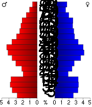 In the county the population was spread out with 23.90% under the age of 18, 6.40% from 18 to 24, 25.80% from 25 to 44, 26.00% from 45 to 64, and 18.00% who were 65 years of age or older. The median age was 42 years. For every 100 females there were 98.50 males. For every 100 females age 18 and over, there were 95.20 males.
The median income for a household in the county was $36,262, and the median income for a family was $43,608. Males had a median income of $40,642 versus $22,261 for females. The per capita income
for the county was $19,167. About 8.40% of families and 12.10% of the population were below the poverty line, including 16.10% of those under age 18 and 13.40% of those age 65 or over.
governments within the county. Survey township
s, as defined by the Public Land Survey System
exist but none are organized. Six city governments have been created, and the rest of the county consists of unorganized territories.
Koochiching County is the location of the fictional town of Frostbite Falls, the home of the animated characters Rocky and Bullwinkle. Frostbite Falls is widely assumed to have been named in honor of International Falls.
U.S. state
A U.S. state is any one of the 50 federated states of the United States of America that share sovereignty with the federal government. Because of this shared sovereignty, an American is a citizen both of the federal entity and of his or her state of domicile. Four states use the official title of...
of Minnesota
Minnesota
Minnesota is a U.S. state located in the Midwestern United States. The twelfth largest state of the U.S., it is the twenty-first most populous, with 5.3 million residents. Minnesota was carved out of the eastern half of the Minnesota Territory and admitted to the Union as the thirty-second state...
. As of 2010, the population was 13,311. Its county seat
County seat
A county seat is an administrative center, or seat of government, for a county or civil parish. The term is primarily used in the United States....
is International Falls
International Falls, Minnesota
International Falls is a city in and the county seat of Koochiching County, Minnesota, United States. The population was 6,424 at the 2010 census....
. A portion of the Bois Forte Indian Reservation
Bois Forte Indian Reservation
Bois Forte Indian Reservation is an Indian reservation formed for the Bois Forte Band of Chippewa...
is in the county. A small part of Voyageurs National Park
Voyageurs National Park
Voyageurs National Park is a United States National Park in northern Minnesota near the town of International Falls. It was established in 1975. The park's name commemorates the voyageurs, French-Canadian fur traders who were the first European settlers to frequently travel through the area...
extends into its northeast corner.
History
Historymakers of Koochiching County were of many occupations. They were explorers, traders, homesteaders, and lumberjacks. They also were teachers, preachers, merchants, engineers, and builders of industry. Settlers came at the beginning of the 1900s and suffered through isolation, illness, harsh weather, and poverty. They built schools, churches, and good roads. Koochiching County is the second largest county next to St. Louis CountySt. Louis County, Minnesota
St. Louis County is a county located in the U.S. state of Minnesota. As of 2010, the population was 200,226. Its county seat is Duluth. It is the largest county by total area in Minnesota, and the second largest in the United States east of the Mississippi River; in land area alone, after Aroostook...
. It is also one of the youngest counties in the state having been created in 1906 after it was separated from Itasca County. The name "Koochiching" comes from either the Ojibwe
Ojibwe language
Ojibwe , also called Anishinaabemowin, is an indigenous language of the Algonquian language family. Ojibwe is characterized by a series of dialects that have local names and frequently local writing systems...
word Gojijiing or Cree
Cree language
Cree is an Algonquian language spoken by approximately 117,000 people across Canada, from the Northwest Territories and Alberta to Labrador, making it the aboriginal language with the highest number of speakers in Canada. It is also spoken in the U.S. state of Montana...
Kocicīhk (recorded in some documents as "Ouchichiq"), both meaning "at the place of inlets," referring to the neighboring Rainy Lake
Rainy Lake
Rainy Lake is a relatively large freshwater lake that straddles the border between the United States and Canada. The Rainy River issues from the west side of the lake and is harnessed to make hydroelectricity for US and Canadian locations. The U.S...
and River
Rainy River (Minnesota-Ontario)
The Rainy River is a river, approximately long, which forms part of the U.S.-Canada border separating northern Minnesota and Northwestern Ontario....
. Reverend J.A. Gilfillan
Joseph Gilfillan
Joseph Alexander Gilfillan was an Episcopal missionary to Native Americans of the Ojibwa Tribe on White Earth Reservation in northern Minnesota during 35 years from 1873 until 1908.-Biography:...
recorded their meaning, "according to some, Neighbor lake, according to others a lake somewhere," possibly referring to Lake Couchiching
Lake Couchiching
Lake Couchiching, from the Ojibwe gojijiing meaning "inlet", is a small lake in Central Ontario separated from Lake Simcoe by a narrow channel. The Trent-Severn Waterway enters Lake Simcoe by the Talbot River and exits this lake by the Severn River which empties into Georgian Bay...
located in southern Ontario
Ontario
Ontario is a province of Canada, located in east-central Canada. It is Canada's most populous province and second largest in total area. It is home to the nation's most populous city, Toronto, and the nation's capital, Ottawa....
. Early European (French) inhabitants gave the names Lac à la Pluie (Rainy Lake) and Rivière à la Pluie (Rainy River) to the nearby bodies of water because of the mist-like rain present at the falls of Rainy River and then to the settlement that became known as International Falls. About 10,000 years ago almost 90% of Koochiching County was covered by Lake Agassiz
Lake Agassiz
Lake Agassiz was an immense glacial lake located in the center of North America. Fed by glacial runoff at the end of the last glacial period, its area was larger than all of the modern Great Lakes combined, and it held more water than contained by all lakes in the world today.-Conception:First...
. When it receded it left low areas of decayed vegetation
Vegetation
Vegetation is a general term for the plant life of a region; it refers to the ground cover provided by plants. It is a general term, without specific reference to particular taxa, life forms, structure, spatial extent, or any other specific botanical or geographic characteristics. It is broader...
(muskeg
Muskeg
Muskeg is an acidic soil type common in Arctic and boreal areas, although it is found in other northern climates as well. Muskeg is approximately synonymous with bogland but muskeg is the standard term in Western Canada and Alaska, while 'bog' is common elsewhere. The term is of Cree origin, maskek...
); as a result, three-quarters of northern Koochiching are underlain with 2 to 50 feet of peat
Peat
Peat is an accumulation of partially decayed vegetation matter or histosol. Peat forms in wetland bogs, moors, muskegs, pocosins, mires, and peat swamp forests. Peat is harvested as an important source of fuel in certain parts of the world...
.
| Year | Democrat Democratic Party (United States) The Democratic Party is one of two major contemporary political parties in the United States, along with the Republican Party. The party's socially liberal and progressive platform is largely considered center-left in the U.S. political spectrum. The party has the lengthiest record of continuous... |
Republican Republican Party (United States) The Republican Party is one of the two major contemporary political parties in the United States, along with the Democratic Party. Founded by anti-slavery expansion activists in 1854, it is often called the GOP . The party's platform generally reflects American conservatism in the U.S... |
|---|---|---|
| 2008 | 53.65% 3649 | 43.55% 2962 |
| 2004 | 50.10% 3662 | 48.42% 3539 |
| 2000 | 42.20% 2903 | 51.21% 3523 |
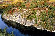
Geography
According to the 2000 census, the county has a total area of 3154.32 square miles (8,169.7 km²), of which 3102.36 square miles (8,035.1 km²) (or 98.35%) is land and 51.96 square miles (134.6 km²) (or 1.65%) is water. Major rivers in the county are Big Fork River, Little Fork River, Rat Root River, Black RiverBlack River (Ontario)
Black River may refer to several rivers by that name in the province of Ontario, Canada.*The Black River in Hastings County, Ontario joins the Moira River near Tweed, Ontario....
, and Rapid River. The highest altitude in the county is in the Northome area which is 1426 feet above sea level which is about 325 feet higher than Rainy Lake
Rainy Lake
Rainy Lake is a relatively large freshwater lake that straddles the border between the United States and Canada. The Rainy River issues from the west side of the lake and is harnessed to make hydroelectricity for US and Canadian locations. The U.S...
. The land surface is mostly flat with swampy areas where Lake Agassiz
Lake Agassiz
Lake Agassiz was an immense glacial lake located in the center of North America. Fed by glacial runoff at the end of the last glacial period, its area was larger than all of the modern Great Lakes combined, and it held more water than contained by all lakes in the world today.-Conception:First...
basin was deepest. There are also deposits of peat
Peat
Peat is an accumulation of partially decayed vegetation matter or histosol. Peat forms in wetland bogs, moors, muskegs, pocosins, mires, and peat swamp forests. Peat is harvested as an important source of fuel in certain parts of the world...
from 1½ to 50 feet in the low areas which is a result from vegetation
Vegetation
Vegetation is a general term for the plant life of a region; it refers to the ground cover provided by plants. It is a general term, without specific reference to particular taxa, life forms, structure, spatial extent, or any other specific botanical or geographic characteristics. It is broader...
. The general surface of Koochiching County is flat with spots of land broken in places by ledges of precambrian
Precambrian
The Precambrian is the name which describes the large span of time in Earth's history before the current Phanerozoic Eon, and is a Supereon divided into several eons of the geologic time scale...
rock. Bed rock in the area includes ely greenstone
Greenschist
Greenschist is a general field petrologic term applied to metamorphic or altered mafic volcanic rock. The term greenstone is sometimes used to refer to greenschist but can refer to other rock types too. The green is due to abundant green chlorite, actinolite and epidote minerals that dominate the...
and greenstone schists that are said to be among the oldest on the planet
Planet
A planet is a celestial body orbiting a star or stellar remnant that is massive enough to be rounded by its own gravity, is not massive enough to cause thermonuclear fusion, and has cleared its neighbouring region of planetesimals.The term planet is ancient, with ties to history, science,...
. In the northeastern tip of the county is a section of Voyageurs National Park
Voyageurs National Park
Voyageurs National Park is a United States National Park in northern Minnesota near the town of International Falls. It was established in 1975. The park's name commemorates the voyageurs, French-Canadian fur traders who were the first European settlers to frequently travel through the area...
and Black Bay. Franz Jevne State Park
Franz Jevne State Park
Franz Jevne State Park is a state park of Minnesota, USA. It is located on the Rainy River between International Falls and Baudette in Koochiching County....
is located on Rainy River between International Falls and Baudette.
Major highways
|
 Minnesota State Highway 46 Minnesota State Highway 46Minnesota State Highway 46 Minnesota State Highway 46 is a highway in north-central Minnesota, which runs from its intersection with U.S. Highway 2 near Deer River and continues northwest to its northern terminus at its intersection with State Highway 1 in Northome.Highway 46 is in length.-Route description:Highway 46...  Minnesota State Highway 65 Minnesota State Highway 65Minnesota State Highway 65 Minnesota State Highway 65 is a highway in east-central and northeast Minnesota, which runs from its intersection with Washington Avenue at the north end of downtown Minneapolis and continues north to its northern terminus at its intersection with U.S...  Minnesota State Highway 217 Minnesota State Highway 217Minnesota State Highway 217 Minnesota State Highway 217 is a highway in northern Minnesota, which runs from its intersection with State Highway 65 at Littlefork and continues east to its eastern terminus at its intersection with U.S...  Minnesota State Highway 332 Minnesota State Highway 332Minnesota State Highway 332 Minnesota State Highway 332 is a short highway in north-central Minnesota, which runs from its intersection with US Highway 71 / State Highway 11 , immediately southwest of International Falls, and continues eastbound to its junction with U.S... |


Adjacent counties
- Rainy River District, OntarioRainy River District, OntarioRainy River District is a district and census division in Northwestern Ontario in the Canadian province of Ontario. It was created in 1885. It is the only division in Ontario that lies completely in the Central time zone. Its seat is Fort Frances...
(north) - St. Louis CountySt. Louis County, MinnesotaSt. Louis County is a county located in the U.S. state of Minnesota. As of 2010, the population was 200,226. Its county seat is Duluth. It is the largest county by total area in Minnesota, and the second largest in the United States east of the Mississippi River; in land area alone, after Aroostook...
(east) - Itasca CountyItasca County, MinnesotaItasca County is a county located in the U.S. state of Minnesota. It is named after Lake Itasca, which is in turn a shortened version the Latin words veritas caput, meaning 'truth' and 'head', a reference to the source of the Mississippi River. As of 2010, the population was 45,058. Its county seat...
(south) - Beltrami CountyBeltrami County, MinnesotaBeltrami County is a county located in the northern part of the U.S. state of Minnesota. As of 2010, the population was 44,442. Its county seat is Bemidji. Portions of the Leech Lake and Red Lake Indian reservations are in the county. The northernmost portion of the Mississippi River flows...
(southwest) - Lake of the Woods CountyLake of the Woods County, MinnesotaLake of the Woods County is a county located in the U.S. state of Minnesota. As of 2010, the population was 4,045. Its county seat is Baudette. The county contains the Northwest Angle, the northernmost point of the Lower 48 States, and includes the U.S. portion of Lake of the Woods, shared with...
(northwest)
National protected areas
- Superior National ForestSuperior National ForestSuperior National Forest, part of the United States National Forest system, is located in the Arrowhead Region of the state of Minnesota between the Canada – United States border and the north shore of Lake Superior...
(part) - Voyageurs National ParkVoyageurs National ParkVoyageurs National Park is a United States National Park in northern Minnesota near the town of International Falls. It was established in 1975. The park's name commemorates the voyageurs, French-Canadian fur traders who were the first European settlers to frequently travel through the area...
(part)
Lakes
- Bartlett Lake
- Battle Lake
- Cameron Lake
- Clear LakeClear Lake, MinnesotaClear Lake is a city in Sherburne County, Minnesota, United States. The population was 545 at the 2010 census.-Geography:According to the United States Census Bureau, the city has a total area of , of which, of it is land and 1.23% is water.U.S...
- Dark Lake
- Franklin Lake
- Larson Lake
- Little Constance Lake
- Little Lake
- Lost LakeLost Lake (Minnesota)Lost Lake is located entirely within the city limits of Mound, Minnesota. It is part of Lake Minnetonka and considered by some to be important to Mound's re-development plans with the hope being that boat users will increase its downtown business traffic...
- Moose LakeMoose Lake, MinnesotaAs of the census of 2000, there were 2,239 people, 577 households, and 294 families residing in the city. The population density was 811.1 people per square mile . There were 628 housing units at an average density of 227.5 per square mile...
- Myrtle Lake
- Nett LakeNett Lake, Koochiching County, MinnesotaNett Lake is an unorganized territory in Koochiching County, Minnesota, United States. The population was 56 at the 2000 census.-Geography:According to the United States Census Bureau, the unorganized territory has a total area of 139.1 square miles , of which, 131.3 square miles of it...
- Pine Lake
- Pocquette Lake
- Rainy LakeRainy LakeRainy Lake is a relatively large freshwater lake that straddles the border between the United States and Canada. The Rainy River issues from the west side of the lake and is harnessed to make hydroelectricity for US and Canadian locations. The U.S...
- Rat Root Lake
- Seretha Lake
- Silversack Lake
- Tuefer Lake
Demographics
As of the censusCensus
A census is the procedure of systematically acquiring and recording information about the members of a given population. It is a regularly occurring and official count of a particular population. The term is used mostly in connection with national population and housing censuses; other common...
of 2000, there were 14,355 people, 6,040 households, and 3,962 families residing in the county. The population density
Population density
Population density is a measurement of population per unit area or unit volume. It is frequently applied to living organisms, and particularly to humans...
was 5 people per square mile (2/km²). There were 7,719 housing units at an average density of 2 per square mile (1/km²). The racial makeup of the county was 96.12% White
Race (United States Census)
Race and ethnicity in the United States Census, as defined by the Federal Office of Management and Budget and the United States Census Bureau, are self-identification data items in which residents choose the race or races with which they most closely identify, and indicate whether or not they are...
, 0.19% Black
Race (United States Census)
Race and ethnicity in the United States Census, as defined by the Federal Office of Management and Budget and the United States Census Bureau, are self-identification data items in which residents choose the race or races with which they most closely identify, and indicate whether or not they are...
or African American
Race (United States Census)
Race and ethnicity in the United States Census, as defined by the Federal Office of Management and Budget and the United States Census Bureau, are self-identification data items in which residents choose the race or races with which they most closely identify, and indicate whether or not they are...
, 2.15% Native American
Race (United States Census)
Race and ethnicity in the United States Census, as defined by the Federal Office of Management and Budget and the United States Census Bureau, are self-identification data items in which residents choose the race or races with which they most closely identify, and indicate whether or not they are...
, 0.17% Asian
Race (United States Census)
Race and ethnicity in the United States Census, as defined by the Federal Office of Management and Budget and the United States Census Bureau, are self-identification data items in which residents choose the race or races with which they most closely identify, and indicate whether or not they are...
, 0.06% Pacific Islander
Race (United States Census)
Race and ethnicity in the United States Census, as defined by the Federal Office of Management and Budget and the United States Census Bureau, are self-identification data items in which residents choose the race or races with which they most closely identify, and indicate whether or not they are...
, 0.08% from other races
Race (United States Census)
Race and ethnicity in the United States Census, as defined by the Federal Office of Management and Budget and the United States Census Bureau, are self-identification data items in which residents choose the race or races with which they most closely identify, and indicate whether or not they are...
, and 1.23% from two or more races. 0.56% of the population were Hispanic
Race (United States Census)
Race and ethnicity in the United States Census, as defined by the Federal Office of Management and Budget and the United States Census Bureau, are self-identification data items in which residents choose the race or races with which they most closely identify, and indicate whether or not they are...
or Latino
Race (United States Census)
Race and ethnicity in the United States Census, as defined by the Federal Office of Management and Budget and the United States Census Bureau, are self-identification data items in which residents choose the race or races with which they most closely identify, and indicate whether or not they are...
of any race. 21.2% were of Norwegian, 19.8% German, 12.3% Swedish and 7.0% Irish
Irish people
The Irish people are an ethnic group who originate in Ireland, an island in northwestern Europe. Ireland has been populated for around 9,000 years , with the Irish people's earliest ancestors recorded having legends of being descended from groups such as the Nemedians, Fomorians, Fir Bolg, Tuatha...
ancestry according to Census 2000.
There were 6,040 households out of which 28.40% had children under the age of 18 living with them, 53.30% were married couples
Marriage
Marriage is a social union or legal contract between people that creates kinship. It is an institution in which interpersonal relationships, usually intimate and sexual, are acknowledged in a variety of ways, depending on the culture or subculture in which it is found...
living together, 8.50% had a female householder with no husband present, and 34.40% were non-families. 30.40% of all households were made up of individuals and 14.50% had someone living alone who was 65 years of age or older. The average household size was 2.33 and the average family size was 2.88.
The median income for a household in the county was $36,262, and the median income for a family was $43,608. Males had a median income of $40,642 versus $22,261 for females. The per capita income
Per capita income
Per capita income or income per person is a measure of mean income within an economic aggregate, such as a country or city. It is calculated by taking a measure of all sources of income in the aggregate and dividing it by the total population...
for the county was $19,167. About 8.40% of families and 12.10% of the population were below the poverty line, including 16.10% of those under age 18 and 13.40% of those age 65 or over.
Communities
Koochiching is unique in Minnesota, in the sense that there are no organized civil townshipCivil township
A civil township is a widely used unit of local government in the United States, subordinate to, and geographic divisions of, a county. Specific responsibilities and the degree of autonomy vary based on each state. Civil townships are distinct from survey townships, but in states that have both,...
governments within the county. Survey township
Survey township
Survey township, sometimes called Congressional township, as used by the United States Public Land Survey System, refers to a square unit of land, that is nominally six miles on a side...
s, as defined by the Public Land Survey System
Public Land Survey System
The Public Land Survey System is a method used in the United States to survey and identify land parcels, particularly for titles and deeds of rural, wild or undeveloped land. Its basic units of area are the township and section. It is sometimes referred to as the rectangular survey system,...
exist but none are organized. Six city governments have been created, and the rest of the county consists of unorganized territories.
| Cities | Unorganized | Unincorporated | Ghost Town |
|---|---|---|---|
|
Rainy Lake, Minnesota Rainy Lake is an unorganized territory in Koochiching County, Minnesota, United States. The population was 4,469 at the 2000 census.-Geography:... East Koochiching, Minnesota East Koochiching is an unorganized territory in Koochiching County, Minnesota, United States. The population was 383 at the 2000 census.-Geography:... South Koochiching, Minnesota South Koochiching is an unorganized territory in Koochiching County, Minnesota, United States. The population was 267 at the 2000 census.-Geography:... Northome (unorganized territory), Minnesota Northome is an unorganized territory in Koochiching County, Minnesota, United States. The term "unorganized territory" is used by the United States Census Bureau to designate a portion of a county that is not included in any legally established minor civil division for the purpose of presenting... Northwest Koochiching, Minnesota Northwest Koochiching is an unorganized territory in Koochiching County, Minnesota, United States. The population was 541 at the 2000 census.-Geography:... Nett Lake, Koochiching County, Minnesota Nett Lake is an unorganized territory in Koochiching County, Minnesota, United States. The population was 56 at the 2000 census.-Geography:According to the United States Census Bureau, the unorganized territory has a total area of 139.1 square miles , of which, 131.3 square miles of it... |
Birchdale, Minnesota Birchdale is an unincorporated community in Koochiching County, Minnesota, United States.The community is located between International Falls and Baudette on Minnesota Highway 11.Franz Jevne State Park is nearby.... Indus, Minnesota Indus is an unincorporated community in Koochiching County, Minnesota, United States.The community is located between International Falls and Baudette on Minnesota State Highway 11.-Further reading:Rand McNally Road Atlas - 2007 edition - Minnesota entry... Island View, Minnesota Island View is an unincorporated community in Koochiching County, Minnesota, United States.The community is located east of International Falls at Rainy Lake on Minnesota State Highway 11.-Further reading:... Loman, Minnesota Loman is an unincoporated community in Koochiching County, Minnesota, United States.The community is located between International Falls and Baudette on Minnesota State Highway 11.-References:*Rand McNally Road Atlas - 2007 edition - Minnesota entry... Margie, Minnesota Margie is an unincorporated community in Koochiching County, Minnesota, United States. Margie is located on U.S. Route 71 southwest of Big Falls. Margie has a post office with ZIP code 56658.... Nett Lake, Koochiching County, Minnesota Nett Lake is an unorganized territory in Koochiching County, Minnesota, United States. The population was 56 at the 2000 census.-Geography:According to the United States Census Bureau, the unorganized territory has a total area of 139.1 square miles , of which, 131.3 square miles of it... Pelland, Minnesota Pelland is an unincorporated community in Koochiching County, Minnesota, United States.The community is located southwest of International Falls at the junction of U.S. Route 71 and Minnesota State Highway 11.... Ray, Minnesota Ray is an unincorporated community in Koochiching County, Minnesota, United States.The community is located southeast of International Falls at the junction of U.S. Route 53 and Minnesota State Highway 217.-Further reading:... |
|
Koochiching County is the location of the fictional town of Frostbite Falls, the home of the animated characters Rocky and Bullwinkle. Frostbite Falls is widely assumed to have been named in honor of International Falls.
See also
- Laurel ComplexLaurel ComplexThe Laurel Complex was a Native American culture in southern Quebec, southern and northwestern Ontario and east-central Manitoba in Canada and northern Michigan, northwestern Wisconsin and northern Minnesota in the United States. They were the first pottery using people of Ontario north of the...
- National Register of Historic Places listings in Koochiching County, MinnesotaNational Register of Historic Places listings in Koochiching County, MinnesotaThis is a list of the National Register of Historic Places listings in Koochiching County, Minnesota. It is intended to be a complete list of the properties and districts on the National Register of Historic Places in Koochiching County, Minnesota, United States...
- Lake Agassiz Peatlands Natural AreaLake Agassiz Peatlands Natural AreaLake Agassiz Peatlands Natural Area is a National Natural Landmark located in Koochiching County, Minnesota. Designated in November 1965 under the Historic Sites Act. , its ownership and oversight are provided by the National Park Service of the United States...
- Northwest Koochiching, MinnesotaNorthwest Koochiching, MinnesotaNorthwest Koochiching is an unorganized territory in Koochiching County, Minnesota, United States. The population was 541 at the 2000 census.-Geography:...
- East Koochiching, MinnesotaEast Koochiching, MinnesotaEast Koochiching is an unorganized territory in Koochiching County, Minnesota, United States. The population was 383 at the 2000 census.-Geography:...
- Iron RangeIron RangeThe Iron Range is a region that makes up the northeastern section of Minnesota in the United States. "The Range", as it is known by locals, is a region with multiple distinct bands of iron ore...
- Ernest OberholtzerErnest OberholtzerErnest Carl Oberholtzer was an American explorer, author and conservationist.Nicknamed "Ober", he was born and raised in Davenport, Iowa, but he lived most of his adult life in Minnesota. Oberholtzer attended Harvard University and received a bachelor of arts degree, but left after one year of...
External links
- County website
- Minnesota Department of TransportationMinnesota Department of TransportationThe Minnesota Department of Transportation oversees transportation by land, water, and air in the U.S. state of Minnesota. The cabinet-level agency is responsible for maintaining the state's trunk highway system The Minnesota Department of Transportation (Mn/DOT, pronounced "min-dot") oversees...
maps (Southwest, Southeast, Northwest, Northeast) - Koochiching County Historical Museum (Int'l Falls)