
Johannes Ruysch
Encyclopedia
Johannes Ruysch a.k.a. Johann Ruijsch or Giovanni Ruisch was an explorer, cartographer, astronomer, manuscript illustrator and painter from the Low Countries
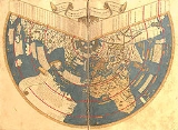
who produced a famous map of the world: the second oldest known printed representation of the New World. This Ruysch map was published and widely distributed in 1507.
. It is thought (see the Beneventanus commentary below) that he accompanied John Cabot on his expedition to North America in 1497 and 1498, or, considering the prevalence of Portuguese names on his 1507 map, a Portuguese ship leaving from Bristol
. Around 1505, Ruysch probably entered the Benedictine monastery of St. Martin in Cologne
as a secular priest. Soon he left for Rome, where pope Julius II gave him a dispensation concerning his priestly occupation. He presumably made his world map there in 1507, appears on payrolls in 1508 and 1509 and seems to have specialized in decorative painting. He is thought to be the “Fleming called John”, a close friend of Raphael
who at one point resided with him. It has been suggested that he assisted and advised Raphael on his 1509-1510 “Astronomia” and other frescoes in the Stanza della segnatura. Not long after, Ruysch went to work at the Portuguese court as cartographer and astronomer, presumably by recommendation of Julius II who was friends with Manuel I of Portugal
. Later, he returned to the St. Martin monastery, suffering from consumption, but able to create a, now lost, astronomical wall painting illustrating the days, months (phases of the Moon), and constellations. He is said to have died at considerable age in 1533 at the monastery, where he had a room adjacent to the library.
Although there had been maps created after these voyages, such as Juan de la Cosa
’s map of the world in 1500 (based on Columbus' second voyage) and the Cantino
world map (circa 1502), the information on these maps was closely held and guarded as state secrets. Often a limited number of copies were made.
) and Martin Waldseemüller
's map of the world and globe of 1507 were very influential, but not very widely published. There is only one original copy of each in existence, and both of these copies were discovered in the 20th century. By contrast, Johannes Ruysch's 1507 map of the world was much more widely published and many copies were produced and still exist. It therefore had a very large influence.
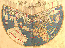 Ruysch's 1507 map of the world was included in the 1507 and 1508 southern editions of Ptolemy's
Geographia, an atlas published in Rome. The editor of the 1507 edition of the Geographia was Evangelista Tosinus and the printer was Bernardinus Venetus de Vitalibus.
The Ruysch map uses Ptolemy's first projection, a coniform projection, as does the Contarini-Rosselli map. Both document Christopher Columbus
' discoveries as well as the discoveries of John Cabot
, as well as including information from Portuguese sources and Marco Polo
's account of his travels. There are notes on his map that clearly were from Portuguese sources.
Newfoundland is shown connected to Asia in the Ruysch map, as [Cabot]] believed. “Sipganus” (Marco Polo’s Japan) is identical with “Spagnola” (Hispaniola
) on the Ruysch map. The presence of codfish is noted on the Ruysch map in the area of the Grand Banks
of Newfoundland. Ruysch’s map contains the discoveries the Portuguese had made along the African coast. Ruysch's map shows Africa as a peninsula surrounded by water. The horn of Africa on Ruysch's map is at approximately the correct latitude. Ruysch's map shows India as a triangular peninsula with Ceylon in the correct proportion and position. Ruysch's map has details about Asia based on data gathered by travelers like Marco Polo, as well as Greco-Roman authorities.
Greenland is shown connected to Newfoundland and Asia on Ruysch's map, and not Europe as earlier maps had showed. Around the north pole, Ruysch drew islands, based on reports in the book Inventio Fortunata
of the English friar Nicholas of Lynne. Interestingly, the island above Norway shows remarkable similarities to Svalbard
, which would not be discovered until 1597 (by Willem Barents
). Ruysch calls it 'European Hyberborea' and a peninsula stretching out towards it is clearly marked with the church of 'Sancti Odulfi', St Olaf's church in Vardø
on the Finnmark
coast.
Commentary:
The church "Sancti Odulfi" shown on Ruysch's map, is not the church in Vardø, Finnmark, but the cathedral in Trondheim. It is placed exactly where Trondheim is supposed to be on the map. This cathedral is the very Saint Olaf Cathedral, as it was built upon his grave.
The church in Vardø was constructed in AD 1307 and was the first church in Finnmark. So, it was in place long before Ruysch made his map, and to be true, no one knows from what saint it was named.
Neither is it any reason for thinking that the island above Norway is meant to be Svalbard. It has no remarkable similarity to Svalbard, and in fact there are four similar islands. Then it is more probable that this feature of the map is inspired by the Inventio Fortunatae, or from the fact that the old cartographers wanted the landmasses to be in balance.
Low Countries
The Low Countries are the historical lands around the low-lying delta of the Rhine, Scheldt, and Meuse rivers, including the modern countries of Belgium, the Netherlands, Luxembourg and parts of northern France and western Germany....
who produced a famous map of the world: the second oldest known printed representation of the New World. This Ruysch map was published and widely distributed in 1507.
Biography
In old documents Ruysch was sometimes called a Fleming or German, but he was likely born in Utrecht in the current NetherlandsNetherlands
The Netherlands is a constituent country of the Kingdom of the Netherlands, located mainly in North-West Europe and with several islands in the Caribbean. Mainland Netherlands borders the North Sea to the north and west, Belgium to the south, and Germany to the east, and shares maritime borders...
. It is thought (see the Beneventanus commentary below) that he accompanied John Cabot on his expedition to North America in 1497 and 1498, or, considering the prevalence of Portuguese names on his 1507 map, a Portuguese ship leaving from Bristol
Bristol
Bristol is a city, unitary authority area and ceremonial county in South West England, with an estimated population of 433,100 for the unitary authority in 2009, and a surrounding Larger Urban Zone with an estimated 1,070,000 residents in 2007...
. Around 1505, Ruysch probably entered the Benedictine monastery of St. Martin in Cologne
Cologne
Cologne is Germany's fourth-largest city , and is the largest city both in the Germany Federal State of North Rhine-Westphalia and within the Rhine-Ruhr Metropolitan Area, one of the major European metropolitan areas with more than ten million inhabitants.Cologne is located on both sides of the...
as a secular priest. Soon he left for Rome, where pope Julius II gave him a dispensation concerning his priestly occupation. He presumably made his world map there in 1507, appears on payrolls in 1508 and 1509 and seems to have specialized in decorative painting. He is thought to be the “Fleming called John”, a close friend of Raphael
Raphael
Raffaello Sanzio da Urbino , better known simply as Raphael, was an Italian painter and architect of the High Renaissance. His work is admired for its clarity of form and ease of composition and for its visual achievement of the Neoplatonic ideal of human grandeur...
who at one point resided with him. It has been suggested that he assisted and advised Raphael on his 1509-1510 “Astronomia” and other frescoes in the Stanza della segnatura. Not long after, Ruysch went to work at the Portuguese court as cartographer and astronomer, presumably by recommendation of Julius II who was friends with Manuel I of Portugal
Manuel I of Portugal
Manuel I , the Fortunate , 14th king of Portugal and the Algarves was the son of Infante Ferdinand, Duke of Viseu, , by his wife, Infanta Beatrice of Portugal...
. Later, he returned to the St. Martin monastery, suffering from consumption, but able to create a, now lost, astronomical wall painting illustrating the days, months (phases of the Moon), and constellations. He is said to have died at considerable age in 1533 at the monastery, where he had a room adjacent to the library.
Age of Discovery
There had been many voyages of discovery immediately before Ruysch created his map :- DiasBartolomeu DiasBartolomeu Dias , a nobleman of the Portuguese royal household, was a Portuguese explorer who sailed around the southernmost tip of Africa in 1488, the first European known to have done so.-Purposes of the Dias expedition:...
’ rounding of the horn of Africa (1487) - the rediscovery of Newfoundland by John CabotJohn CabotJohn Cabot was an Italian navigator and explorer whose 1497 discovery of parts of North America is commonly held to have been the first European encounter with the continent of North America since the Norse Vikings in the eleventh century...
(1497) (rediscovery, as the NorseNorsemenNorsemen is used to refer to the group of people as a whole who spoke what is now called the Old Norse language belonging to the North Germanic branch of Indo-European languages, especially Norwegian, Icelandic, Faroese, Swedish and Danish in their earlier forms.The meaning of Norseman was "people...
had been to Newfoundland centuries before and settled there) - Vasco da GamaVasco da GamaVasco da Gama, 1st Count of Vidigueira was a Portuguese explorer, one of the most successful in the Age of Discovery and the commander of the first ships to sail directly from Europe to India...
’s travel to India (1499) - the explorations of the Caribbean and South America by ColumbusChristopher ColumbusChristopher Columbus was an explorer, colonizer, and navigator, born in the Republic of Genoa, in northwestern Italy. Under the auspices of the Catholic Monarchs of Spain, he completed four voyages across the Atlantic Ocean that led to general European awareness of the American continents in the...
(1492-93, 1493-94, 1498, 1502-04) - visits to the Caribbean and South America by VespucciVespucciVespucci may refer to:*Amerigo Vespucci*Amerigo Vespucci *Ponte Amerigo Vespucci*Simonetta Vespucci...
(1499, 1501-02)
Although there had been maps created after these voyages, such as Juan de la Cosa
Juan de la Cosa
Juan de la Cosa was a Spanish cartographer, conquistador and explorer. He made the earliest extant European world map to incorporate the territories of the Americas that were discovered in the 15th century, sailed first 3 voyages with Christopher Columbus, and was the owner/captain of the Santa...
’s map of the world in 1500 (based on Columbus' second voyage) and the Cantino
Cantino planisphere
The Cantino planisphere is the earliest surviving map showing Portuguese Discoveries in the east and west. It is named after Alberto Cantino, an agent for the Duke of Ferrara, who successfully smuggled it from Portugal to Italy in 1502...
world map (circa 1502), the information on these maps was closely held and guarded as state secrets. Often a limited number of copies were made.
Publicizing the Shape of the World
This situation changed drastically from 1506 to 1507 when three separate efforts to produce world maps were published. The Contarini-Rosselli map of 1506 (now in the British LibraryBritish Library
The British Library is the national library of the United Kingdom, and is the world's largest library in terms of total number of items. The library is a major research library, holding over 150 million items from every country in the world, in virtually all known languages and in many formats,...
) and Martin Waldseemüller
Martin Waldseemüller
Martin Waldseemüller was a German cartographer...
's map of the world and globe of 1507 were very influential, but not very widely published. There is only one original copy of each in existence, and both of these copies were discovered in the 20th century. By contrast, Johannes Ruysch's 1507 map of the world was much more widely published and many copies were produced and still exist. It therefore had a very large influence.
The Ruysch Map of 1507
Ptolemy
Claudius Ptolemy , was a Roman citizen of Egypt who wrote in Greek. He was a mathematician, astronomer, geographer, astrologer, and poet of a single epigram in the Greek Anthology. He lived in Egypt under Roman rule, and is believed to have been born in the town of Ptolemais Hermiou in the...
Geographia, an atlas published in Rome. The editor of the 1507 edition of the Geographia was Evangelista Tosinus and the printer was Bernardinus Venetus de Vitalibus.
The Ruysch map uses Ptolemy's first projection, a coniform projection, as does the Contarini-Rosselli map. Both document Christopher Columbus
Christopher Columbus
Christopher Columbus was an explorer, colonizer, and navigator, born in the Republic of Genoa, in northwestern Italy. Under the auspices of the Catholic Monarchs of Spain, he completed four voyages across the Atlantic Ocean that led to general European awareness of the American continents in the...
' discoveries as well as the discoveries of John Cabot
John Cabot
John Cabot was an Italian navigator and explorer whose 1497 discovery of parts of North America is commonly held to have been the first European encounter with the continent of North America since the Norse Vikings in the eleventh century...
, as well as including information from Portuguese sources and Marco Polo
Marco Polo
Marco Polo was a Venetian merchant traveler from the Venetian Republic whose travels are recorded in Il Milione, a book which did much to introduce Europeans to Central Asia and China. He learned about trading whilst his father and uncle, Niccolò and Maffeo, travelled through Asia and apparently...
's account of his travels. There are notes on his map that clearly were from Portuguese sources.
Newfoundland is shown connected to Asia in the Ruysch map, as [Cabot]] believed. “Sipganus” (Marco Polo’s Japan) is identical with “Spagnola” (Hispaniola
Hispaniola
Hispaniola is a major island in the Caribbean, containing the two sovereign states of the Dominican Republic and Haiti. The island is located between the islands of Cuba to the west and Puerto Rico to the east, within the hurricane belt...
) on the Ruysch map. The presence of codfish is noted on the Ruysch map in the area of the Grand Banks
Grand Banks
The Grand Banks of Newfoundland are a group of underwater plateaus southeast of Newfoundland on the North American continental shelf. These areas are relatively shallow, ranging from in depth. The cold Labrador Current mixes with the warm waters of the Gulf Stream here.The mixing of these waters...
of Newfoundland. Ruysch’s map contains the discoveries the Portuguese had made along the African coast. Ruysch's map shows Africa as a peninsula surrounded by water. The horn of Africa on Ruysch's map is at approximately the correct latitude. Ruysch's map shows India as a triangular peninsula with Ceylon in the correct proportion and position. Ruysch's map has details about Asia based on data gathered by travelers like Marco Polo, as well as Greco-Roman authorities.
Greenland is shown connected to Newfoundland and Asia on Ruysch's map, and not Europe as earlier maps had showed. Around the north pole, Ruysch drew islands, based on reports in the book Inventio Fortunata
Inventio Fortunata
Inventio Fortunata , "Fortunate, or fortune-making, discovery", is a lost book, probably dating from the 14th century, containing a description of the North Pole as a magnetic island surrounded by a giant whirlpool and four continents...
of the English friar Nicholas of Lynne. Interestingly, the island above Norway shows remarkable similarities to Svalbard
Svalbard
Svalbard is an archipelago in the Arctic, constituting the northernmost part of Norway. It is located north of mainland Europe, midway between mainland Norway and the North Pole. The group of islands range from 74° to 81° north latitude , and from 10° to 35° east longitude. Spitsbergen is the...
, which would not be discovered until 1597 (by Willem Barents
Willem Barents
Willem Barentsz was a Dutch navigator, cartographer, explorer, and a leader of early expeditions to the far north....
). Ruysch calls it 'European Hyberborea' and a peninsula stretching out towards it is clearly marked with the church of 'Sancti Odulfi', St Olaf's church in Vardø
Vardø
is a town and a municipality in Finnmark county in the extreme northeast part of Norway.Vardø was established as a municipality on 1 January 1838 . The law required that all cities should be separated from their rural districts, but because of a low population and very few voters, this was...
on the Finnmark
Finnmark
or Finnmárku is a county in the extreme northeast of Norway. By land it borders Troms county to the west, Finland to the south and Russia to the east, and by water, the Norwegian Sea to the northwest, and the Barents Sea to the north and northeast.The county was formerly known as Finmarkens...
coast.
Map Commentary
There was a map commentary also included in the 1508 edition, entitled Orbis nouo descriptio and written by an Italian Celestinian monk named Marcus Beneventanus. Beneventanus, wrote in the commentary on the Ruysch map for the 1508 Ptolemy edition:- Johannes Ruysch of Germany, in my judgment a most exact geographer, and a most painstaking one in delineating the globe, to whose aid in this little work I am indebted, has told me that he sailed from the South of England, and penetrated as far as the fifty-third degree of north latitude, and on that parallel he sailed west toward the shores of the East, bearing a little northward and observed many islands.
Commentary:
The church "Sancti Odulfi" shown on Ruysch's map, is not the church in Vardø, Finnmark, but the cathedral in Trondheim. It is placed exactly where Trondheim is supposed to be on the map. This cathedral is the very Saint Olaf Cathedral, as it was built upon his grave.
The church in Vardø was constructed in AD 1307 and was the first church in Finnmark. So, it was in place long before Ruysch made his map, and to be true, no one knows from what saint it was named.
Neither is it any reason for thinking that the island above Norway is meant to be Svalbard. It has no remarkable similarity to Svalbard, and in fact there are four similar islands. Then it is more probable that this feature of the map is inspired by the Inventio Fortunatae, or from the fact that the old cartographers wanted the landmasses to be in balance.
External links
- Ruysch 1506 map showing Africa and India
- Ruysch 1506 map of the world showing North America and South America
- The Mapping of America, Seymour I. Schwartz, Ralph E. Ehrenberg, Abrams, New York, 1980.
- The New World in Maps: The First Hundred Years, John T. Day (St. Olaf College), The Newberry Library, 1988.
- Wikisource:Catholic Encyclopedia (1913)/John Ruysch