

Islands of Michigan
Encyclopedia
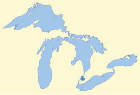
The following is a list of islands of Michigan. Michigan
has the second longest coastline of any state after Alaska
. Being bordered by four of the five Great Lakes
—Erie
, Huron
, Michigan
, and Superior
—Michigan also has 64,980 inland lakes and ponds, as well as innumerable rivers, that may contain their own islands included in this list. The majority of the islands are within the Great Lakes. Other islands can also be found within other waterways of the Great Lake system, including Lake St. Clair
, St. Clair River
, Detroit River
, and St. Marys River.
The largest of all the islands is Isle Royale
in Lake Superior, which, in addition to its waters and other surrounding islands, is organized as Isle Royale National Park
. Isle Royale itself is 206 square miles (533.5 km²). The most populated island is Grosse Ile
with approximately 10,000 residents, located in the Detroit River about 10 miles (16 km) south of Detroit. The majority of Michigan's islands are uninhabited and very small. Some of these otherwise unusable islands have been used for the large number of Michigan's lighthouses to aid in shipping throughout the Great Lakes, while others have been set aside as nature reserve
s. Many islands in Michigan have the same name, even some that are in the same municipality and body of water, such as Gull, Long, or Round islands.
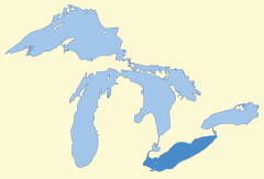
Only Monroe County
has territory in the westernmost portion of Lake Erie
. The islands in the southern portion of the county are part of the North Maumee Bay Archeological District
, in which Turtle Island
is the only island in the state of Michigan that is shared by another state. This remote island is cut in half and shared with Ohio
. While not distinct named islands in their own right, Sterling State Park
and Pointe Mouillee
are situated on several islands.
Lake Huron
is the second largest of the Great Lakes
(after Lake Superior
) with a surface area of 23010 square miles (59,595.6 km²). Michigan
is the only U.S. state
to border Lake Huron, while the portion of the lake on the other side of the international border belongs to the Canadian
province of Ontario
. The vast majority of Michigan's islands in Lake Huron are centered around Drummond Island
in the northernmost portion of the state's lake territory. Drummond Island is the largest of Michigan's islands in Lake Huron and is the second largest Michigan island after Lake Superior's Isle Royale
. Another large group of islands is the Les Cheneaux Islands
archipelago, which itself contains dozens of small islands. Many of the lake's islands are very small and uninhabited.
As the most popular tourist destination in the state, Mackinac Island
is the most well known of Lake Huron's islands. Drummond Island is the most populous of Michigan's islands in Lake Huron, with a population of 992 at the 2000 census. While Mackinac Island had a population of only 553, there are thousands more seasonal workers and tourists during the summer months.
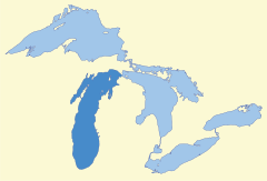
Michigan only has islands in Lake Michigan
in the northern portion of the lake in Green Bay, Big Bay de Noc
, Little Bay de Noc
, and along the Niagara Escarpment
. Interestingly, there are no islands in the southern half of Lake Michigan. The largest and most populated of Michigan's islands in Lake Michigan is Beaver Island
at 55.8 square miles (144.5 km²) and 551 residents. Some of the smaller islands surrounding Beaver Island are part of the larger Michigan Islands National Wildlife Refuge
.
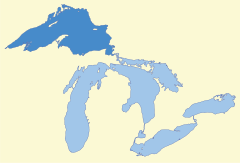 Lake Superior
is the largest of the Great Lakes, and the coastline is sparsely populated. At 206 square miles (533.5 km²), Isle Royale
is the largest Michigan island and is the center of Isle Royale National Park
, which itself contains over 450 islands. The following is a list of islands in Lake Superior that are not part of Isle Royale National Park. For those islands, see the list of islands in Isle Royale National Park.
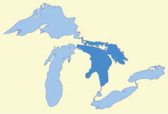
Lake St. Clair
connects Lake Huron
and Lake Erie
through the St. Clair River
in the north and the Detroit River
in the south. At 430 square miles (1,113.7 km²), it is one of the largest non-Great Lakes in the United States, but it only contains a small number of islands near the mouth of the St. Clair River, where all of the following islands are located. The largest of these islands is Harsens Island
, and all the islands are in Clay Township
in St. Clair County
.
runs for 32 miles (51 km) and connects Lake St. Clair
to Lake Erie
. For its entire length, it carries the international border between the United States and Canada, and some islands belong to Ontario
. All islands on the American side belong to Wayne County
.
Most of the islands are very small and uninhabited, and many of these islands around the southern portion of the river serve as wildlife refuges as part of the Detroit River International Wildlife Refuge
. The largest and most populous island is Grosse Ile
at 9 square miles (23.3 km²) and a population of around 10,000. Most of the islands are around and closely connected to Grosse Ile. The city of Gibraltar
also occupies several islands in the southern portion of the river. Some of the islands have also been geologically modified throughout the industrialization of the area. Stony Island and Grassy Island
have been largely formed from dredged sediments, and Zug Island
and Elizabeth Park
were once connected to the mainland.
and Lake Huron
at the easternmost point of the Upper Peninsula
. It carries the international border throughout its length, and some of the islands belong to neighboring Ontario
. The largest of Michigan's islands in the river are Sugar Island
and Neebish Island
. Wider portions of the river are designated as Lake George, Lake Nicolet, and the Munuscong Lake. The whole length of the Michigan portion of the river is part of Chippewa County
.
.
. While it is not the largest inland lake in Michigan, it does contain the most inland islands. At its shortest distance, it is located less than one mile (0.6 km) from Lake Huron
, but the two are not connected. Grand Lake contains 14 islands, of which Grand Island is by far the largest.
Michigan
Michigan is a U.S. state located in the Great Lakes Region of the United States of America. The name Michigan is the French form of the Ojibwa word mishigamaa, meaning "large water" or "large lake"....
has the second longest coastline of any state after Alaska
Alaska
Alaska is the largest state in the United States by area. It is situated in the northwest extremity of the North American continent, with Canada to the east, the Arctic Ocean to the north, and the Pacific Ocean to the west and south, with Russia further west across the Bering Strait...
. Being bordered by four of the five Great Lakes
Great Lakes
The Great Lakes are a collection of freshwater lakes located in northeastern North America, on the Canada – United States border. Consisting of Lakes Superior, Michigan, Huron, Erie, and Ontario, they form the largest group of freshwater lakes on Earth by total surface, coming in second by volume...
—Erie
Lake Erie
Lake Erie is the fourth largest lake of the five Great Lakes in North America, and the tenth largest globally. It is the southernmost, shallowest, and smallest by volume of the Great Lakes and therefore also has the shortest average water residence time. It is bounded on the north by the...
, Huron
Lake Huron
Lake Huron is one of the five Great Lakes of North America. Hydrologically, it comprises the larger portion of Lake Michigan-Huron. It is bounded on the east by the Canadian province of Ontario and on the west by the state of Michigan in the United States...
, Michigan
Lake Michigan
Lake Michigan is one of the five Great Lakes of North America and the only one located entirely within the United States. It is the second largest of the Great Lakes by volume and the third largest by surface area, after Lake Superior and Lake Huron...
, and Superior
Lake Superior
Lake Superior is the largest of the five traditionally-demarcated Great Lakes of North America. It is bounded to the north by the Canadian province of Ontario and the U.S. state of Minnesota, and to the south by the U.S. states of Wisconsin and Michigan. It is the largest freshwater lake in the...
—Michigan also has 64,980 inland lakes and ponds, as well as innumerable rivers, that may contain their own islands included in this list. The majority of the islands are within the Great Lakes. Other islands can also be found within other waterways of the Great Lake system, including Lake St. Clair
Lake Saint Clair (North America)
Lake St. Clair is a fresh-water lake named after Clare of Assisi that lies between the Province of Ontario and the State of Michigan, and its midline also forms the boundary between Canada and the United States of America. Lake St. Clair includes the Anchor Bay along the Metro Detroit coastline...
, St. Clair River
St. Clair River
The St. Clair River is a river in central North America which drains Lake Huron into Lake St Clair, forming part of the international boundary between the Canadian province of Ontario and the U.S. state of Michigan...
, Detroit River
Detroit River
The Detroit River is a strait in the Great Lakes system. The name comes from the French Rivière du Détroit, which translates literally as "River of the Strait". The Detroit River has served an important role in the history of Detroit and is one of the busiest waterways in the world. The river...
, and St. Marys River.
The largest of all the islands is Isle Royale
Isle Royale
Isle Royale is an island of the Great Lakes, located in the northwest of Lake Superior, and part of the state of Michigan. The island and the 450 surrounding smaller islands and waters make up Isle Royale National Park....
in Lake Superior, which, in addition to its waters and other surrounding islands, is organized as Isle Royale National Park
Isle Royale National Park
Isle Royale National Park is a U.S. National Park in the state of Michigan. Isle Royale, the largest island in Lake Superior, is over 45 miles in length and 9 miles wide at its widest point. The park is made of Isle Royale itself and approximately 400 smaller islands, along with any submerged...
. Isle Royale itself is 206 square miles (533.5 km²). The most populated island is Grosse Ile
Grosse Ile (Michigan)
Grosse Ile is the largest island in the Detroit River and is the most populated island in the state of Michigan. It is on the American side of the river and is part of Wayne County. The island is approximately 9.6 mi² and has a population of 10,894...
with approximately 10,000 residents, located in the Detroit River about 10 miles (16 km) south of Detroit. The majority of Michigan's islands are uninhabited and very small. Some of these otherwise unusable islands have been used for the large number of Michigan's lighthouses to aid in shipping throughout the Great Lakes, while others have been set aside as nature reserve
Nature reserve
A nature reserve is a protected area of importance for wildlife, flora, fauna or features of geological or other special interest, which is reserved and managed for conservation and to provide special opportunities for study or research...
s. Many islands in Michigan have the same name, even some that are in the same municipality and body of water, such as Gull, Long, or Round islands.
Lake Erie
Only Monroe County
Monroe County, Michigan
Monroe County is a county in the U.S. state of Michigan. According to the U.S. Census Bureau, the 2010 population is 152,021. The largest city and county seat is Monroe. The U.S. Census Bureau defines all of Monroe County as conterminous with the Monroe Metropolitan Area...
has territory in the westernmost portion of Lake Erie
Lake Erie
Lake Erie is the fourth largest lake of the five Great Lakes in North America, and the tenth largest globally. It is the southernmost, shallowest, and smallest by volume of the Great Lakes and therefore also has the shortest average water residence time. It is bounded on the north by the...
. The islands in the southern portion of the county are part of the North Maumee Bay Archeological District
North Maumee Bay Archeological District
The North Maumee Bay Archeological District is a historic district located in the southeasternmost corner of Erie Township in Monroe County, Michigan...
, in which Turtle Island
Turtle Island (Lake Erie)
__NOEDITSECTION__Turtle Island is a remote island in the western portion of Lake Erie in the United States. The island has unique political status, as its ownership is divided between the U.S. states of Michigan and Ohio, even though the island has no residents or use. The island is located...
is the only island in the state of Michigan that is shared by another state. This remote island is cut in half and shared with Ohio
Ohio
Ohio is a Midwestern state in the United States. The 34th largest state by area in the U.S.,it is the 7th‑most populous with over 11.5 million residents, containing several major American cities and seven metropolitan areas with populations of 500,000 or more.The state's capital is Columbus...
. While not distinct named islands in their own right, Sterling State Park
Sterling State Park
Sterling State Park in the United States is the only Michigan state park located on the shores of Lake Erie. The park encompasses 2.03 mi² just northeast of Monroe, Michigan in Frenchtown Charter Township in Monroe County. The park was established in 1920. The park sits just north of where the...
and Pointe Mouillee
Pointe Mouillee State Game Area
Pointe Mouillee State Game Area is a state game area located primarily in Berlin Charter Township in the northeasternmost corner of Monroe County, Michigan. It consists of of coastal wetlands in Lake Erie near the mouth of the Huron River...
are situated on several islands.
| Island | Municipality | County | Coordinates |
|---|---|---|---|
| Bar Point Shoal Detroit River Light The Detroit River Light, also known as Bar Point Shoal Light, was first established as a lightship in 1875. The current sparkplug lighthouse was built in 1885. It sits in Lake Erie, south of the mouth of the Detroit River, from land and about from the Ambassador Bridge in the Detroit River. It... |
Berlin Township Berlin Charter Township, Michigan Berlin Charter Township is a charter township of Monroe County in the U.S. state of Michigan. At the 2000 census, the township population was 6,924. Berlin Charter Township was organized from the northern portion of previously established Frenchtown Charter Township, and the township boundaries... |
Monroe Monroe County, Michigan Monroe County is a county in the U.S. state of Michigan. According to the U.S. Census Bureau, the 2010 population is 152,021. The largest city and county seat is Monroe. The U.S. Census Bureau defines all of Monroe County as conterminous with the Monroe Metropolitan Area... |
42.00083°N 83.14111°W |
| Gard Island | Erie Township Erie Township, Michigan Erie Township is a civil township of Monroe County in the U.S. state of Michigan. The population was 4,850 at the 2000 census. The township is served by Mason Consolidated Schools.-Geography:... |
Monroe Monroe County, Michigan Monroe County is a county in the U.S. state of Michigan. According to the U.S. Census Bureau, the 2010 population is 152,021. The largest city and county seat is Monroe. The U.S. Census Bureau defines all of Monroe County as conterminous with the Monroe Metropolitan Area... |
41.74861°N 83.44361°W |
| Indian Island | Erie Township Erie Township, Michigan Erie Township is a civil township of Monroe County in the U.S. state of Michigan. The population was 4,850 at the 2000 census. The township is served by Mason Consolidated Schools.-Geography:... |
Monroe Monroe County, Michigan Monroe County is a county in the U.S. state of Michigan. According to the U.S. Census Bureau, the 2010 population is 152,021. The largest city and county seat is Monroe. The U.S. Census Bureau defines all of Monroe County as conterminous with the Monroe Metropolitan Area... |
41.74722°N 83.45361°W |
| North Cape | Erie Township Erie Township, Michigan Erie Township is a civil township of Monroe County in the U.S. state of Michigan. The population was 4,850 at the 2000 census. The township is served by Mason Consolidated Schools.-Geography:... |
Monroe Monroe County, Michigan Monroe County is a county in the U.S. state of Michigan. According to the U.S. Census Bureau, the 2010 population is 152,021. The largest city and county seat is Monroe. The U.S. Census Bureau defines all of Monroe County as conterminous with the Monroe Metropolitan Area... |
41.74361°N 83.42916°W |
| Pointe Mouillee Pointe Mouillee State Game Area Pointe Mouillee State Game Area is a state game area located primarily in Berlin Charter Township in the northeasternmost corner of Monroe County, Michigan. It consists of of coastal wetlands in Lake Erie near the mouth of the Huron River... |
Berlin Township Berlin Charter Township, Michigan Berlin Charter Township is a charter township of Monroe County in the U.S. state of Michigan. At the 2000 census, the township population was 6,924. Berlin Charter Township was organized from the northern portion of previously established Frenchtown Charter Township, and the township boundaries... |
Monroe Monroe County, Michigan Monroe County is a county in the U.S. state of Michigan. According to the U.S. Census Bureau, the 2010 population is 152,021. The largest city and county seat is Monroe. The U.S. Census Bureau defines all of Monroe County as conterminous with the Monroe Metropolitan Area... |
42.00416°N 83.19416°W |
| Smiths Island | Monroe Monroe, Michigan Monroe is a city in the U.S. state of Michigan. The population was 20,733 at the 2010 census. It is the largest city and county seat of Monroe County. The city is bordered on the south by Monroe Charter Township, but both are politically independent. The city is located approximately 14 miles ... |
Monroe Monroe County, Michigan Monroe County is a county in the U.S. state of Michigan. According to the U.S. Census Bureau, the 2010 population is 152,021. The largest city and county seat is Monroe. The U.S. Census Bureau defines all of Monroe County as conterminous with the Monroe Metropolitan Area... |
41.87250°N 83.36111°W |
| Sterling State Park Sterling State Park Sterling State Park in the United States is the only Michigan state park located on the shores of Lake Erie. The park encompasses 2.03 mi² just northeast of Monroe, Michigan in Frenchtown Charter Township in Monroe County. The park was established in 1920. The park sits just north of where the... |
Frenchtown Township Frenchtown Charter Township, Michigan Frenchtown Charter Township is a charter township of Monroe County in the U.S. state of Michigan. The population was 20,777 at the 2000 census. Frenchtown is the second most populated township in Monroe County after Bedford Township... |
Monroe Monroe County, Michigan Monroe County is a county in the U.S. state of Michigan. According to the U.S. Census Bureau, the 2010 population is 152,021. The largest city and county seat is Monroe. The U.S. Census Bureau defines all of Monroe County as conterminous with the Monroe Metropolitan Area... |
41.91333°N 83.33472°W |
| Turtle Island Turtle Island (Lake Erie) __NOEDITSECTION__Turtle Island is a remote island in the western portion of Lake Erie in the United States. The island has unique political status, as its ownership is divided between the U.S. states of Michigan and Ohio, even though the island has no residents or use. The island is located... |
Erie Township Erie Township, Michigan Erie Township is a civil township of Monroe County in the U.S. state of Michigan. The population was 4,850 at the 2000 census. The township is served by Mason Consolidated Schools.-Geography:... |
Monroe Monroe County, Michigan Monroe County is a county in the U.S. state of Michigan. According to the U.S. Census Bureau, the 2010 population is 152,021. The largest city and county seat is Monroe. The U.S. Census Bureau defines all of Monroe County as conterminous with the Monroe Metropolitan Area... |
41.75250°N 83.39083°W |
Lake Huron
Lake Huron
Lake Huron
Lake Huron is one of the five Great Lakes of North America. Hydrologically, it comprises the larger portion of Lake Michigan-Huron. It is bounded on the east by the Canadian province of Ontario and on the west by the state of Michigan in the United States...
is the second largest of the Great Lakes
Great Lakes
The Great Lakes are a collection of freshwater lakes located in northeastern North America, on the Canada – United States border. Consisting of Lakes Superior, Michigan, Huron, Erie, and Ontario, they form the largest group of freshwater lakes on Earth by total surface, coming in second by volume...
(after Lake Superior
Lake Superior
Lake Superior is the largest of the five traditionally-demarcated Great Lakes of North America. It is bounded to the north by the Canadian province of Ontario and the U.S. state of Minnesota, and to the south by the U.S. states of Wisconsin and Michigan. It is the largest freshwater lake in the...
) with a surface area of 23010 square miles (59,595.6 km²). Michigan
Michigan
Michigan is a U.S. state located in the Great Lakes Region of the United States of America. The name Michigan is the French form of the Ojibwa word mishigamaa, meaning "large water" or "large lake"....
is the only U.S. state
U.S. state
A U.S. state is any one of the 50 federated states of the United States of America that share sovereignty with the federal government. Because of this shared sovereignty, an American is a citizen both of the federal entity and of his or her state of domicile. Four states use the official title of...
to border Lake Huron, while the portion of the lake on the other side of the international border belongs to the Canadian
Canada
Canada is a North American country consisting of ten provinces and three territories. Located in the northern part of the continent, it extends from the Atlantic Ocean in the east to the Pacific Ocean in the west, and northward into the Arctic Ocean...
province of Ontario
Ontario
Ontario is a province of Canada, located in east-central Canada. It is Canada's most populous province and second largest in total area. It is home to the nation's most populous city, Toronto, and the nation's capital, Ottawa....
. The vast majority of Michigan's islands in Lake Huron are centered around Drummond Island
Drummond Township, Michigan
Drummond Township is a civil township of Chippewa County in the U.S. state of Michigan. The population was 992 at the 2000 census.The township consists of Drummond Island, one of the largest islands in Lake Huron. M-134 runs through the western portion of the island...
in the northernmost portion of the state's lake territory. Drummond Island is the largest of Michigan's islands in Lake Huron and is the second largest Michigan island after Lake Superior's Isle Royale
Isle Royale
Isle Royale is an island of the Great Lakes, located in the northwest of Lake Superior, and part of the state of Michigan. The island and the 450 surrounding smaller islands and waters make up Isle Royale National Park....
. Another large group of islands is the Les Cheneaux Islands
Les Cheneaux Islands
Les Cheneaux Islands are a group of 36 small islands, some inhabited, along 12 miles of Lake Huron shoreline on the southeastern tip of the Upper Peninsula of Michigan in the United States. The name is French for "the Channels", noting the many channels between the islands in the group...
archipelago, which itself contains dozens of small islands. Many of the lake's islands are very small and uninhabited.
As the most popular tourist destination in the state, Mackinac Island
Mackinac Island
Mackinac Island is an island and resort area covering in land area, part of the U.S. state of Michigan. It is located in Lake Huron, at the eastern end of the Straits of Mackinac, between the state's Upper and Lower Peninsulas. The island was home to a Native American settlement before European...
is the most well known of Lake Huron's islands. Drummond Island is the most populous of Michigan's islands in Lake Huron, with a population of 992 at the 2000 census. While Mackinac Island had a population of only 553, there are thousands more seasonal workers and tourists during the summer months.
Lake Michigan
Michigan only has islands in Lake Michigan
Lake Michigan
Lake Michigan is one of the five Great Lakes of North America and the only one located entirely within the United States. It is the second largest of the Great Lakes by volume and the third largest by surface area, after Lake Superior and Lake Huron...
in the northern portion of the lake in Green Bay, Big Bay de Noc
Big Bay de Noc
Big Bay de Noc is a bay in the Upper Peninsula of the U.S. state of Michigan. The bay, which opens into Lake Michigan's Green Bay, is enclosed by Delta County...
, Little Bay de Noc
Little Bay de Noc
Little Bay de Noc is a bay in the Upper Peninsula of the U.S. state of Michigan. The bay opens into Lake Michigan's Green Bay.The bay, consisting of approximately 30,000 acres , is enclosed by Delta County...
, and along the Niagara Escarpment
Niagara Escarpment
The Niagara Escarpment is a long escarpment, or cuesta, in the United States and Canada that runs westward from New York State, through Ontario, Michigan, Wisconsin and Illinois...
. Interestingly, there are no islands in the southern half of Lake Michigan. The largest and most populated of Michigan's islands in Lake Michigan is Beaver Island
Beaver Island (Lake Michigan)
Beaver Island is the largest island in Lake Michigan and part of the Beaver Island archipelago. Once home to a unique American monarchy, the island is now a popular tourist and vacation destination....
at 55.8 square miles (144.5 km²) and 551 residents. Some of the smaller islands surrounding Beaver Island are part of the larger Michigan Islands National Wildlife Refuge
Michigan Islands National Wildlife Refuge
The Michigan Islands National Wildlife Refuge is a designation for eight Michigan islands in the North American Great Lakes. Owned by the United States federal government, they were set aside for ecosystem protection purposes by President Franklin D. Roosevelt 1943.Charity, Little Charity,...
.
| Island | Municipality | County | Coordinates |
|---|---|---|---|
| Bassett Island | Peninsula Township Peninsula Township, Michigan Peninsula Township is a civil township of Grand Traverse County in the U.S. state of Michigan. As of the 2000 census, the township population was 5,265. The township is coterminous with the Old Mission Peninsula, which projects into the Grand Traverse Bay of Lake Michigan. The Old Mission Point... |
Grand Traverse Grand Traverse County, Michigan -Air service:*Grand Traverse County is served by Cherry Capital Airport, which is located near Traverse City.-Demographics:As of the census of 2000, there were 77,654 people, 30,396 households, and 20,730 families residing in the county. The population density was 167 people per square mile . ... |
44.87250°N 85.57056°W |
| Beaver Island Beaver Island (Lake Michigan) Beaver Island is the largest island in Lake Michigan and part of the Beaver Island archipelago. Once home to a unique American monarchy, the island is now a popular tourist and vacation destination.... |
Peaine Peaine Township, Michigan Peaine Township is a civil township of Charlevoix County in the U.S. state of Michigan. As of the 2000 census, the township population was 244... / St. James St. James Township, Michigan St. James Township is a civil township of Charlevoix County in the U.S. state of Michigan. As of the 2000 census, the township population was 307.-History:... |
Charlevoix Charlevoix County, Michigan -Airports:*Beaver Island is served by two airlines:**Welke Airport**Beaver Island Airport-Ferry service:*Beaver Island Boat Company maintains a regular auto ferry from Charlevoix:*The Ironton Ferry at Ironton, Michigan crosses the south arm of Lake Charlevoix... |
45.66472°N 85.55722°W |
| Bellow Island | Suttons Bay Township Suttons Bay Township, Michigan Suttons Bay Township is a civil township of Leelanau County in the U.S. state of Michigan. The population was 2,982 at the 2000 census. The village of Suttons Bay is located within the township... |
Leelanau Leelanau County, Michigan -History:The county's name is said to be a Native American word meaning "delight of life", but it is a neologism made up by Indian agent and ethnographer Henry Schoolcraft, who sometimes gave the name "Leelinau" to Native American women in his tales. He created many faux Indian place names in... |
45.10000°N 85.56750°W |
| Butlers Island | Gladstone Gladstone, Michigan Gladstone is a city in Delta County in the U.S. state of Michigan. First settled in 1877, Gladstone's original name was Saunders Point. The population was 5,032 at the 2000 census.... |
Delta Delta County, Michigan -Demographics:As of the census of 2000, there were 38,520 people, 15,836 households, and 10,689 families residing in the county. The population density was 33 people per square mile . There were 19,223 housing units at an average density of 16 per square mile... |
45.86111°N 87.01583°W |
| Epoufette Island | Hendricks Township Hendricks Township, Michigan Hendricks Township is a civil township of Mackinac County in the U.S. state of Michigan. The population was 183 at the 2000 census.- Communities :... |
Mackinac Mackinac County, Michigan -Local Airports:*Mackinac County Airport *Mackinac Island Airport -Airline service:The nearest airports with scheduled passenger service are:*Chippewa County International Airport in Sault Ste... |
46.04417°N 85.20167°W |
| Fisherman Island | Norwood Township Norwood Township, Michigan Norwood Township is a civil township of Charlevoix County in the U.S. state of Michigan. The population was 714 at the 2000 census.-Geography:... |
Charlevoix Charlevoix County, Michigan -Airports:*Beaver Island is served by two airlines:**Welke Airport**Beaver Island Airport-Ferry service:*Beaver Island Boat Company maintains a regular auto ferry from Charlevoix:*The Ironton Ferry at Ironton, Michigan crosses the south arm of Lake Charlevoix... |
45.28722°N 85.35917°W |
| Garden Island Garden Island (Michigan) Garden Island is an uninhabited 4,990 acre island located in the Beaver Island archipelago in northern Lake Michigan. It is almost wholly owned by the U.S. state of Michigan and is overseen by the Michigan Department of Natural Resources as part of the Beaver Island State Wildlife Research Area.... |
St. James Township St. James Township, Michigan St. James Township is a civil township of Charlevoix County in the U.S. state of Michigan. As of the 2000 census, the township population was 307.-History:... |
Charlevoix Charlevoix County, Michigan -Airports:*Beaver Island is served by two airlines:**Welke Airport**Beaver Island Airport-Ferry service:*Beaver Island Boat Company maintains a regular auto ferry from Charlevoix:*The Ironton Ferry at Ironton, Michigan crosses the south arm of Lake Charlevoix... |
45.80472°N 85.49444°W |
| Grape Island | St. James Township St. James Township, Michigan St. James Township is a civil township of Charlevoix County in the U.S. state of Michigan. As of the 2000 census, the township population was 307.-History:... |
Charlevoix Charlevoix County, Michigan -Airports:*Beaver Island is served by two airlines:**Welke Airport**Beaver Island Airport-Ferry service:*Beaver Island Boat Company maintains a regular auto ferry from Charlevoix:*The Ironton Ferry at Ironton, Michigan crosses the south arm of Lake Charlevoix... |
45.78000°N 85.42056°W |
| Gravel Island | Hudson Township Hudson Township, Mackinac County, Michigan Hudson Township is a civil township of Mackinac County in the U.S. state of Michigan. As of the 2000 census, the township population was 214.- Communities :... |
Mackinac Mackinac County, Michigan -Local Airports:*Mackinac County Airport *Mackinac Island Airport -Airline service:The nearest airports with scheduled passenger service are:*Chippewa County International Airport in Sault Ste... |
46.07750°N 85.30556°W |
| Gravelly Island | Fairbanks Township Fairbanks Township, Michigan Fairbanks Township is a civil township of Delta County in the U.S. state of Michigan. As of the 2000 census, the township population was 321.-Communities:... |
Delta Delta County, Michigan -Demographics:As of the census of 2000, there were 38,520 people, 15,836 households, and 10,689 families residing in the county. The population density was 33 people per square mile . There were 19,223 housing units at an average density of 16 per square mile... |
45.52167°N 86.72583°W |
| Green Island | St. Ignace St. Ignace, Michigan Saint Ignace, usually written as St. Ignace, is a city in the U.S. state of Michigan. As of the 2000 census, the city population was 2,678. It is the county seat of Mackinac County. From the Lower Peninsula, St. Ignace is the gateway to the Upper Peninsula.St... |
Mackinac Mackinac County, Michigan -Local Airports:*Mackinac County Airport *Mackinac Island Airport -Airline service:The nearest airports with scheduled passenger service are:*Chippewa County International Airport in Sault Ste... |
45.83500°N 84.74972°W |
| Gull Island | Fairbanks Township Fairbanks Township, Michigan Fairbanks Township is a civil township of Delta County in the U.S. state of Michigan. As of the 2000 census, the township population was 321.-Communities:... |
Delta Delta County, Michigan -Demographics:As of the census of 2000, there were 38,520 people, 15,836 households, and 10,689 families residing in the county. The population density was 33 people per square mile . There were 19,223 housing units at an average density of 16 per square mile... |
45.51000°N 86.71944°W |
| Gull Island | St. James Township St. James Township, Michigan St. James Township is a civil township of Charlevoix County in the U.S. state of Michigan. As of the 2000 census, the township population was 307.-History:... |
Charlevoix Charlevoix County, Michigan -Airports:*Beaver Island is served by two airlines:**Welke Airport**Beaver Island Airport-Ferry service:*Beaver Island Boat Company maintains a regular auto ferry from Charlevoix:*The Ironton Ferry at Ironton, Michigan crosses the south arm of Lake Charlevoix... |
45.70250°N 85.83861°W |
| Hat Island Hat Island (Lake Michigan) Hat Island is a small island on the eastern edge of the Beaver Island archipelago in Lake Michigan. It is about 10 acres in size and located in eastern St. James Township, Charlevoix County, Michigan... |
St. James Township St. James Township, Michigan St. James Township is a civil township of Charlevoix County in the U.S. state of Michigan. As of the 2000 census, the township population was 307.-History:... |
Charlevoix Charlevoix County, Michigan -Airports:*Beaver Island is served by two airlines:**Welke Airport**Beaver Island Airport-Ferry service:*Beaver Island Boat Company maintains a regular auto ferry from Charlevoix:*The Ironton Ferry at Ironton, Michigan crosses the south arm of Lake Charlevoix... |
45.81583°N 85.30000°W |
| High Island High Island (Michigan) High Island is an island in Lake Michigan and is part of the Beaver Island archipelago. It is in size. The island is owned by the U.S. state of Michigan and is managed by the Michigan Department of Natural Resources as part of the Beaver Islands State Wildlife Management Area.High Island got its... |
St. James Township St. James Township, Michigan St. James Township is a civil township of Charlevoix County in the U.S. state of Michigan. As of the 2000 census, the township population was 307.-History:... |
Charlevoix Charlevoix County, Michigan -Airports:*Beaver Island is served by two airlines:**Welke Airport**Beaver Island Airport-Ferry service:*Beaver Island Boat Company maintains a regular auto ferry from Charlevoix:*The Ironton Ferry at Ironton, Michigan crosses the south arm of Lake Charlevoix... |
45.72444°N 85.67194°W |
| Hog Island Hog Island (Michigan) Hog Island, an uninhabited 2,075-acre island in Lake Michigan, is the fourth largest island in the Beaver Island archipelago. It is owned by the U.S... |
St. James Township St. James Township, Michigan St. James Township is a civil township of Charlevoix County in the U.S. state of Michigan. As of the 2000 census, the township population was 307.-History:... |
Charlevoix Charlevoix County, Michigan -Airports:*Beaver Island is served by two airlines:**Welke Airport**Beaver Island Airport-Ferry service:*Beaver Island Boat Company maintains a regular auto ferry from Charlevoix:*The Ironton Ferry at Ironton, Michigan crosses the south arm of Lake Charlevoix... |
45.79250°N 85.36361°W |
| Horseshoe Island | St. James Township St. James Township, Michigan St. James Township is a civil township of Charlevoix County in the U.S. state of Michigan. As of the 2000 census, the township population was 307.-History:... |
Charlevoix Charlevoix County, Michigan -Airports:*Beaver Island is served by two airlines:**Welke Airport**Beaver Island Airport-Ferry service:*Beaver Island Boat Company maintains a regular auto ferry from Charlevoix:*The Ironton Ferry at Ironton, Michigan crosses the south arm of Lake Charlevoix... |
45.77361°N 85.36139°W |
| Ile Aux Galets Ile Aux Galets Ile aux Galets or Gallets, and also known as Skillagallee or Skillagalee Island, is located in northeast Lake Michigan approximately 7.0 miles northwest of Cross Village, Michigan... |
Cross Village Township Cross Village Township, Michigan Cross Village Township is a civil township of Emmet County in the U.S. state of Michigan. As of the 2000 census, the township population was 294.-Communities:... |
Emmet Emmet County, Michigan Emmet County is a county in the U.S. state of Michigan. As of the 2000 census, the population was 31,437. The county seat is Petoskey.The county was formed April 1, 1840, from Mackinac County. It was first named Tonedagana County and renamed Emmet County on March 8, 1843... |
45.67639°N 85.17306°W |
| Little Gull Island | Fairbanks Township Fairbanks Township, Michigan Fairbanks Township is a civil township of Delta County in the U.S. state of Michigan. As of the 2000 census, the township population was 321.-Communities:... |
Delta Delta County, Michigan -Demographics:As of the census of 2000, there were 38,520 people, 15,836 households, and 10,689 families residing in the county. The population density was 33 people per square mile . There were 19,223 housing units at an average density of 16 per square mile... |
45.49889°N 86.71444°W |
| Little Hog Island | Hudson Township Hudson Township, Mackinac County, Michigan Hudson Township is a civil township of Mackinac County in the U.S. state of Michigan. As of the 2000 census, the township population was 214.- Communities :... |
Mackinac Mackinac County, Michigan -Local Airports:*Mackinac County Airport *Mackinac Island Airport -Airline service:The nearest airports with scheduled passenger service are:*Chippewa County International Airport in Sault Ste... |
46.07000°N 85.29028°W |
| Little Island | St. James Township St. James Township, Michigan St. James Township is a civil township of Charlevoix County in the U.S. state of Michigan. As of the 2000 census, the township population was 307.-History:... |
Charlevoix Charlevoix County, Michigan -Airports:*Beaver Island is served by two airlines:**Welke Airport**Beaver Island Airport-Ferry service:*Beaver Island Boat Company maintains a regular auto ferry from Charlevoix:*The Ironton Ferry at Ironton, Michigan crosses the south arm of Lake Charlevoix... |
45.78806°N 85.50250°W |
| Little Summer Island | Fairbanks Township Fairbanks Township, Michigan Fairbanks Township is a civil township of Delta County in the U.S. state of Michigan. As of the 2000 census, the township population was 321.-Communities:... |
Delta Delta County, Michigan -Demographics:As of the census of 2000, there were 38,520 people, 15,836 households, and 10,689 families residing in the county. The population density was 33 people per square mile . There were 19,223 housing units at an average density of 16 per square mile... |
45.60611°N 86.69389°W |
| Marion Island | Peninsula Township Peninsula Township, Michigan Peninsula Township is a civil township of Grand Traverse County in the U.S. state of Michigan. As of the 2000 census, the township population was 5,265. The township is coterminous with the Old Mission Peninsula, which projects into the Grand Traverse Bay of Lake Michigan. The Old Mission Point... |
Grand Traverse Grand Traverse County, Michigan -Air service:*Grand Traverse County is served by Cherry Capital Airport, which is located near Traverse City.-Demographics:As of the census of 2000, there were 77,654 people, 30,396 households, and 20,730 families residing in the county. The population density was 167 people per square mile . ... |
44.86583°N 85.57556°W |
| Naubinway Island | Garfield Township Garfield Township, Mackinac County, Michigan Garfield Township is a civil township of Mackinac County in the U.S. state of Michigan. The population was 1,251 at the 2000 census.- Communities :... |
Mackinac Mackinac County, Michigan -Local Airports:*Mackinac County Airport *Mackinac Island Airport -Airline service:The nearest airports with scheduled passenger service are:*Chippewa County International Airport in Sault Ste... |
46.07556°N 85.44528°W |
| North Fox Island Fox Islands (Michigan) The Fox Islands consist of the North Fox and South Fox islands, in Lake Michigan. The uninhabited islands are approximately 17 miles northwest of Cathead Point near the tip of the Leelanau Peninsula of Michigan and about southwest of Beaver Island. The three islands form part of an archipelago... |
Leelanau Township Leelanau Township, Michigan Leelanau Township is a civil township of Leelanau County in the U.S. state of Michigan. The population was 2,139 at the 2000 census.- Communities and landmarks :... |
Leelanau Leelanau County, Michigan -History:The county's name is said to be a Native American word meaning "delight of life", but it is a neologism made up by Indian agent and ethnographer Henry Schoolcraft, who sometimes gave the name "Leelinau" to Native American women in his tales. He created many faux Indian place names in... |
45.48000°N 85.77583°W |
| North Manitou Island North Manitou Island North Manitou Island is located in Lake Michigan, approximately west-northwest of Leland, Michigan. It is nearly eight miles long and over four miles wide, with of shoreline. It has a land area of 57.876 km² and has no population... |
Leland Township Leland Township, Michigan Leland Township is a civil township of Leelanau County in the U.S. state of Michigan. As of the early 2000s, the unincorporated community of Leland, which lies totally within the township, was the county seat of Leelanau County... |
Leelanau Leelanau County, Michigan -History:The county's name is said to be a Native American word meaning "delight of life", but it is a neologism made up by Indian agent and ethnographer Henry Schoolcraft, who sometimes gave the name "Leelinau" to Native American women in his tales. He created many faux Indian place names in... |
45.10833°N 86.02083°W |
| Pismire Island Pismire Island Pismire Island is a small island in Lake Michigan of approximately in size. It is part of the Beaver Island archipelago, the Michigan Islands National Wildlife Refuge, and the Michigan Islands Wilderness Area. It is managed by the U.S. Fish and Wildlife Service as a satellite of the Seney... |
St. James Township St. James Township, Michigan St. James Township is a civil township of Charlevoix County in the U.S. state of Michigan. As of the 2000 census, the township population was 307.-History:... |
Charlevoix Charlevoix County, Michigan -Airports:*Beaver Island is served by two airlines:**Welke Airport**Beaver Island Airport-Ferry service:*Beaver Island Boat Company maintains a regular auto ferry from Charlevoix:*The Ironton Ferry at Ironton, Michigan crosses the south arm of Lake Charlevoix... |
45.76833°N 85.44528°W |
| Poverty Island Poverty Island Poverty Island is a small island in the U.S. state of Michigan. The island is within Delta County in Lake Michigan and is home to an abandoned lighthouse which is in disrepair. Poverty Island is currently owned by the federal government.... |
Fairbanks Township Fairbanks Township, Michigan Fairbanks Township is a civil township of Delta County in the U.S. state of Michigan. As of the 2000 census, the township population was 321.-Communities:... |
Delta Delta County, Michigan -Demographics:As of the census of 2000, there were 38,520 people, 15,836 households, and 10,689 families residing in the county. The population density was 33 people per square mile . There were 19,223 housing units at an average density of 16 per square mile... |
45.52750°N 86.66444°W |
| Round Island | Ford River Township Ford River Township, Michigan Ford River Township is a civil township of Delta County in the U.S. state of Michigan. The population was 2,241 at the 2000 census.-Geography:... |
Delta Delta County, Michigan -Demographics:As of the census of 2000, there were 38,520 people, 15,836 households, and 10,689 families residing in the county. The population density was 33 people per square mile . There were 19,223 housing units at an average density of 16 per square mile... |
45.64278°N 87.16806°W |
| Round Island | Bay de Noc Township Bay de Noc Township, Michigan Bay de Noc Township is a civil township of Delta County in the U.S. state of Michigan. As of the 2000 census, the township population was 329. The township covers the southern portion of the peninsula separating Little Bay de Noc and Big Bay de Noc on Lake Michigan.Ensign Township is to the north... |
Delta Delta County, Michigan -Demographics:As of the census of 2000, there were 38,520 people, 15,836 households, and 10,689 families residing in the county. The population density was 33 people per square mile . There were 19,223 housing units at an average density of 16 per square mile... |
45.74556°N 86.76222°W |
| St. Helena Island | Moran Township Moran Township, Michigan Moran Township is a civil township of Mackinac County in the U.S. state of Michigan. The population was 1,080 at the 2000 census.-Communities:... |
Mackinac Mackinac County, Michigan -Local Airports:*Mackinac County Airport *Mackinac Island Airport -Airline service:The nearest airports with scheduled passenger service are:*Chippewa County International Airport in Sault Ste... |
45.85833°N 84.87083°W |
| St. Martin Island St. Martin Island St. Martin Island is located off the Garden Peninsula in Delta County in the U.S. state of Michigan. It is the southernmost island in Michigan that is part of a line of islands at the mouth of the bay of Green Bay and is part of the Niagara Escarpment.... |
Fairbanks Township Fairbanks Township, Michigan Fairbanks Township is a civil township of Delta County in the U.S. state of Michigan. As of the 2000 census, the township population was 321.-Communities:... |
Delta Delta County, Michigan -Demographics:As of the census of 2000, there were 38,520 people, 15,836 households, and 10,689 families residing in the county. The population density was 33 people per square mile . There were 19,223 housing units at an average density of 16 per square mile... |
45.49778°N 86.77028°W |
| St. Vital Island | Bay de Noc Township Bay de Noc Township, Michigan Bay de Noc Township is a civil township of Delta County in the U.S. state of Michigan. As of the 2000 census, the township population was 329. The township covers the southern portion of the peninsula separating Little Bay de Noc and Big Bay de Noc on Lake Michigan.Ensign Township is to the north... |
Delta Delta County, Michigan -Demographics:As of the census of 2000, there were 38,520 people, 15,836 households, and 10,689 families residing in the county. The population density was 33 people per square mile . There were 19,223 housing units at an average density of 16 per square mile... |
45.79972°N 86.75972°W |
| Sand Island | Escanaba Escanaba, Michigan Escanaba is a city in the U.S. state of Michigan, located in the banana belt on the state's Upper Peninsula. As of the 2000 census, the city population was 13,140, making it the third-largest city in the Upper Peninsula after Marquette and Sault Ste. Marie... |
Delta Delta County, Michigan -Demographics:As of the census of 2000, there were 38,520 people, 15,836 households, and 10,689 families residing in the county. The population density was 33 people per square mile . There were 19,223 housing units at an average density of 16 per square mile... |
45.74056°N 87.04472°W |
| Shoe Island Shoe Island (Lake Michigan) Shoe Island is a small island or islet in the Beaver Island archipelago in Lake Michigan. It is about in size and located in eastern St. James Township, Charlevoix County, Michigan... |
St. James Township St. James Township, Michigan St. James Township is a civil township of Charlevoix County in the U.S. state of Michigan. As of the 2000 census, the township population was 307.-History:... |
Charlevoix Charlevoix County, Michigan -Airports:*Beaver Island is served by two airlines:**Welke Airport**Beaver Island Airport-Ferry service:*Beaver Island Boat Company maintains a regular auto ferry from Charlevoix:*The Ironton Ferry at Ironton, Michigan crosses the south arm of Lake Charlevoix... |
45.80694°N 85.29778°W |
| Snake Island | Fairbanks Township Fairbanks Township, Michigan Fairbanks Township is a civil township of Delta County in the U.S. state of Michigan. As of the 2000 census, the township population was 321.-Communities:... |
Delta Delta County, Michigan -Demographics:As of the census of 2000, there were 38,520 people, 15,836 households, and 10,689 families residing in the county. The population density was 33 people per square mile . There were 19,223 housing units at an average density of 16 per square mile... |
45.73806°N 86.65750°W |
| South Fox Island Fox Islands (Michigan) The Fox Islands consist of the North Fox and South Fox islands, in Lake Michigan. The uninhabited islands are approximately 17 miles northwest of Cathead Point near the tip of the Leelanau Peninsula of Michigan and about southwest of Beaver Island. The three islands form part of an archipelago... |
Leelanau Township Leelanau Township, Michigan Leelanau Township is a civil township of Leelanau County in the U.S. state of Michigan. The population was 2,139 at the 2000 census.- Communities and landmarks :... |
Leelanau Leelanau County, Michigan -History:The county's name is said to be a Native American word meaning "delight of life", but it is a neologism made up by Indian agent and ethnographer Henry Schoolcraft, who sometimes gave the name "Leelinau" to Native American women in his tales. He created many faux Indian place names in... |
45.44083°N 85.87972°W |
| South Manitou Island South Manitou Island South Manitou Island is located in Lake Michigan, approximately west of Leland, Michigan. It is part of Leelanau County and the Sleeping Bear Dunes National Lakeshore. The uninhabited island is in land area and can be accessed by a ferry service from Leland... |
Glen Arbor Township Glen Arbor Township, Michigan Glen Arbor Township is a civil township of Leelanau County in the U.S. state of Michigan. The population was 788 at the 2000 census.-Geography:... |
Leelanau Leelanau County, Michigan -History:The county's name is said to be a Native American word meaning "delight of life", but it is a neologism made up by Indian agent and ethnographer Henry Schoolcraft, who sometimes gave the name "Leelinau" to Native American women in his tales. He created many faux Indian place names in... |
44.99917°N 86.12028°W |
| Squaw Island | St. James Township St. James Township, Michigan St. James Township is a civil township of Charlevoix County in the U.S. state of Michigan. As of the 2000 census, the township population was 307.-History:... |
Charlevoix Charlevoix County, Michigan -Airports:*Beaver Island is served by two airlines:**Welke Airport**Beaver Island Airport-Ferry service:*Beaver Island Boat Company maintains a regular auto ferry from Charlevoix:*The Ironton Ferry at Ironton, Michigan crosses the south arm of Lake Charlevoix... |
45.83694°N 85.58667°W |
| Summer Island Summer Island Summer Island is an island in Lake Michigan. It is located 2.5 miles miles off the southern tip of the Garden Peninsula in the state of Michigan... |
Fairbanks Township Fairbanks Township, Michigan Fairbanks Township is a civil township of Delta County in the U.S. state of Michigan. As of the 2000 census, the township population was 321.-Communities:... |
Delta Delta County, Michigan -Demographics:As of the census of 2000, there were 38,520 people, 15,836 households, and 10,689 families residing in the county. The population density was 33 people per square mile . There were 19,223 housing units at an average density of 16 per square mile... |
45.56333°N 86.63639°W |
| Whiskey Island | St. James Township St. James Township, Michigan St. James Township is a civil township of Charlevoix County in the U.S. state of Michigan. As of the 2000 census, the township population was 307.-History:... |
Charlevoix Charlevoix County, Michigan -Airports:*Beaver Island is served by two airlines:**Welke Airport**Beaver Island Airport-Ferry service:*Beaver Island Boat Company maintains a regular auto ferry from Charlevoix:*The Ironton Ferry at Ironton, Michigan crosses the south arm of Lake Charlevoix... |
45.81111°N 85.59444°W |
| Temperance Island | Bliss Township Bliss Township, Michigan Bliss Township is a civil township of Emmet County in the U.S. state of Michigan. As of the 2000 census, the township population was 572.-Geography:... |
Emmet Emmet County, Michigan Emmet County is a county in the U.S. state of Michigan. As of the 2000 census, the population was 31,437. The county seat is Petoskey.The county was formed April 1, 1840, from Mackinac County. It was first named Tonedagana County and renamed Emmet County on March 8, 1843... |
45.76306°N 85.03361°W |
| Waugoshance Island | Bliss Township Bliss Township, Michigan Bliss Township is a civil township of Emmet County in the U.S. state of Michigan. As of the 2000 census, the township population was 572.-Geography:... |
Emmet Emmet County, Michigan Emmet County is a county in the U.S. state of Michigan. As of the 2000 census, the population was 31,437. The county seat is Petoskey.The county was formed April 1, 1840, from Mackinac County. It was first named Tonedagana County and renamed Emmet County on March 8, 1843... |
45.76389°N 85.06778°W |
Lake Superior
Lake Superior
Lake Superior is the largest of the five traditionally-demarcated Great Lakes of North America. It is bounded to the north by the Canadian province of Ontario and the U.S. state of Minnesota, and to the south by the U.S. states of Wisconsin and Michigan. It is the largest freshwater lake in the...
is the largest of the Great Lakes, and the coastline is sparsely populated. At 206 square miles (533.5 km²), Isle Royale
Isle Royale
Isle Royale is an island of the Great Lakes, located in the northwest of Lake Superior, and part of the state of Michigan. The island and the 450 surrounding smaller islands and waters make up Isle Royale National Park....
is the largest Michigan island and is the center of Isle Royale National Park
Isle Royale National Park
Isle Royale National Park is a U.S. National Park in the state of Michigan. Isle Royale, the largest island in Lake Superior, is over 45 miles in length and 9 miles wide at its widest point. The park is made of Isle Royale itself and approximately 400 smaller islands, along with any submerged...
, which itself contains over 450 islands. The following is a list of islands in Lake Superior that are not part of Isle Royale National Park. For those islands, see the list of islands in Isle Royale National Park.
| Island | Municipality | County | Coordinates |
|---|---|---|---|
| Au Train Island | Onota Township Onota Township, Michigan Onota Township is a civil township of Alger County in the U.S. state of Michigan. As of the 2000 census, the township population was 310.-Communities:There are no incorporated municipalities in the township.... |
Alger Alger County, Michigan Alger County is a county in the U.S. state of Michigan. As of the 2010 census, the population was 9,601. Its county seat is Munising. The Pictured Rocks National Lakeshore is located within the county.-History:... |
46.48528°N 86.89306°W |
| Garlic Island | Powell Township Powell Township, Michigan Powell Township is a civil township of Marquette County in the U.S. state of Michigan. The population was 724 at the 2000 census.- Communities :... |
Marquette Marquette County, Michigan -National protected areas:* Hiawatha National Forest * Huron National Wildlife Refuge* Ottawa National Forest -University:Northern Michigan University is a four-year university, established in 1899, located in Marquette, Michigan, on Michigan's Upper Peninsula... |
46.70444°N 87.54139°W |
| Grand Island | Grand Island Township Grand Island Township, Michigan Grand Island Township is a civil township of Alger County in the U.S. state of Michigan. The township consists entirely of the Grand Island in Lake Superior just north of Munising. As of the 2000 census, the township population was 45... |
Alger Alger County, Michigan Alger County is a county in the U.S. state of Michigan. As of the 2010 census, the population was 9,601. Its county seat is Munising. The Pictured Rocks National Lakeshore is located within the county.-History:... |
46.51667°N 86.66667°W |
| Granite Island Granite Island (Michigan) Granite Island is a 2½ acre island in Lake Superior located about northwest of Marquette in the Upper Peninsula of the U.S. state of Michigan. Posted upon it is the Granite Island Lighthouse, also known as Granite Island Light Station, and is "one of the oldest surviving lighthouses on Lake... |
Powell Township Powell Township, Michigan Powell Township is a civil township of Marquette County in the U.S. state of Michigan. The population was 724 at the 2000 census.- Communities :... |
Marquette Marquette County, Michigan -National protected areas:* Hiawatha National Forest * Huron National Wildlife Refuge* Ottawa National Forest -University:Northern Michigan University is a four-year university, established in 1899, located in Marquette, Michigan, on Michigan's Upper Peninsula... |
46.72083°N 87.41139°W |
| Gull Island | Powell Township Powell Township, Michigan Powell Township is a civil township of Marquette County in the U.S. state of Michigan. The population was 724 at the 2000 census.- Communities :... |
Marquette Marquette County, Michigan -National protected areas:* Hiawatha National Forest * Huron National Wildlife Refuge* Ottawa National Forest -University:Northern Michigan University is a four-year university, established in 1899, located in Marquette, Michigan, on Michigan's Upper Peninsula... |
46.95000°N 87.95694°W |
| Huron Islands Huron Islands The Huron Islands are a group of eight small, rocky islands in Lake Superior, located about three miles offshore from the mouth of the Huron River in northwestern Marquette County, Michigan. Together they comprise the Huron National Wildlife Refuge, which was established by President Theodore... |
Powell Township Powell Township, Michigan Powell Township is a civil township of Marquette County in the U.S. state of Michigan. The population was 724 at the 2000 census.- Communities :... |
Marquette Marquette County, Michigan -National protected areas:* Hiawatha National Forest * Huron National Wildlife Refuge* Ottawa National Forest -University:Northern Michigan University is a four-year university, established in 1899, located in Marquette, Michigan, on Michigan's Upper Peninsula... |
46.95444°N 87.97722°W |
| Iroquois Island | Bay Mills Township Bay Mills Township, Michigan Bay Mills Township is a civil township of Chippewa County in the U.S. state of Michigan. As of the 2000 census, the township population was 1,214.-Communities:*Bay Mills Indian Community is a Chippewa community within the township.... |
Chippewa Chippewa County, Michigan -National protected areas:* Harbor Island National Wildlife Refuge* Hiawatha National Forest * Whitefish Point Unit of the Seney National Wildlife Refuge-Demographics:... |
46.49167°N 84.68250°W |
| Larus Island | Marquette Township Marquette Township, Marquette County, Michigan Marquette Charter Township is a charter township of Marquette County in the U.S. state of Michigan. The population was 3,286 at the 2000 census... |
Marquette Marquette County, Michigan -National protected areas:* Hiawatha National Forest * Huron National Wildlife Refuge* Ottawa National Forest -University:Northern Michigan University is a four-year university, established in 1899, located in Marquette, Michigan, on Michigan's Upper Peninsula... |
46.61139°N 87.43083°W |
| Lighthouse Island | Powell Township Powell Township, Michigan Powell Township is a civil township of Marquette County in the U.S. state of Michigan. The population was 724 at the 2000 census.- Communities :... |
Marquette Marquette County, Michigan -National protected areas:* Hiawatha National Forest * Huron National Wildlife Refuge* Ottawa National Forest -University:Northern Michigan University is a four-year university, established in 1899, located in Marquette, Michigan, on Michigan's Upper Peninsula... |
46.96250°N 87.99944°W |
| Little Presque Island | Marquette Township Marquette Township, Marquette County, Michigan Marquette Charter Township is a charter township of Marquette County in the U.S. state of Michigan. The population was 3,286 at the 2000 census... |
Marquette Marquette County, Michigan -National protected areas:* Hiawatha National Forest * Huron National Wildlife Refuge* Ottawa National Forest -University:Northern Michigan University is a four-year university, established in 1899, located in Marquette, Michigan, on Michigan's Upper Peninsula... |
46.63889°N 87.45889°W |
| Manitou Island | Grant Township Grant Township, Keweenaw County, Michigan Grant Township is a civil township of Keweenaw County in the U.S. state of Michigan. As of the 2000 census, the township population was 172.-Geography:... |
Keweenaw Keweenaw County, Michigan -Demographics:As of the census of 2000, there were 2,301 people, 998 households, and 604 families residing in the county. The population density was 4 people per square mile . There were 2,327 housing units at an average density of 4 per square mile... |
47.41667°N 87.61667°W |
| McIntyre Island | Powell Township Powell Township, Michigan Powell Township is a civil township of Marquette County in the U.S. state of Michigan. The population was 724 at the 2000 census.- Communities :... |
Marquette Marquette County, Michigan -National protected areas:* Hiawatha National Forest * Huron National Wildlife Refuge* Ottawa National Forest -University:Northern Michigan University is a four-year university, established in 1899, located in Marquette, Michigan, on Michigan's Upper Peninsula... |
46.95222°N 87.97028°W |
| Middle Island | Marquette Township Marquette Township, Marquette County, Michigan Marquette Charter Township is a charter township of Marquette County in the U.S. state of Michigan. The population was 3,286 at the 2000 census... |
Marquette Marquette County, Michigan -National protected areas:* Hiawatha National Forest * Huron National Wildlife Refuge* Ottawa National Forest -University:Northern Michigan University is a four-year university, established in 1899, located in Marquette, Michigan, on Michigan's Upper Peninsula... |
46.59472°N 87.40111°W |
| Naomikong Island | Whitefish Township Whitefish Township, Michigan Whitefish Township is a civil township of Chippewa County in the U.S. state of Michigan. The population was 588 at the 2000 census.-Geography:... |
Chippewa Chippewa County, Michigan -National protected areas:* Harbor Island National Wildlife Refuge* Hiawatha National Forest * Whitefish Point Unit of the Seney National Wildlife Refuge-Demographics:... |
46.48389°N 84.95694°W |
| Partridge Island | Marquette Township Marquette Township, Marquette County, Michigan Marquette Charter Township is a charter township of Marquette County in the U.S. state of Michigan. The population was 3,286 at the 2000 census... |
Marquette Marquette County, Michigan -National protected areas:* Hiawatha National Forest * Huron National Wildlife Refuge* Ottawa National Forest -University:Northern Michigan University is a four-year university, established in 1899, located in Marquette, Michigan, on Michigan's Upper Peninsula... |
46.60222°N 87.41556°W |
| Picnic Rocks | Marquette Marquette, Michigan Marquette is a city in the U.S. state of Michigan and the county seat of Marquette County. The population was 21,355 at the 2010 census, making it the most populated city of the Upper Peninsula. Marquette is a major port on Lake Superior, primarily for shipping iron ore and is the home of Northern... |
Marquette Marquette County, Michigan -National protected areas:* Hiawatha National Forest * Huron National Wildlife Refuge* Ottawa National Forest -University:Northern Michigan University is a four-year university, established in 1899, located in Marquette, Michigan, on Michigan's Upper Peninsula... |
46.55583°N 87.37722°W |
| Porters Island | Grant Township Grant Township, Keweenaw County, Michigan Grant Township is a civil township of Keweenaw County in the U.S. state of Michigan. As of the 2000 census, the township population was 172.-Geography:... |
Keweenaw Keweenaw County, Michigan -Demographics:As of the census of 2000, there were 2,301 people, 998 households, and 604 families residing in the county. The population density was 4 people per square mile . There were 2,327 housing units at an average density of 4 per square mile... |
47.47500°N 87.88306°W |
| Presque Isle | Marquette Marquette, Michigan Marquette is a city in the U.S. state of Michigan and the county seat of Marquette County. The population was 21,355 at the 2010 census, making it the most populated city of the Upper Peninsula. Marquette is a major port on Lake Superior, primarily for shipping iron ore and is the home of Northern... |
Marquette Marquette County, Michigan -National protected areas:* Hiawatha National Forest * Huron National Wildlife Refuge* Ottawa National Forest -University:Northern Michigan University is a four-year university, established in 1899, located in Marquette, Michigan, on Michigan's Upper Peninsula... |
46.58806°N 87.38167°W |
| Presque Isle Point Rocks | Marquette Marquette, Michigan Marquette is a city in the U.S. state of Michigan and the county seat of Marquette County. The population was 21,355 at the 2010 census, making it the most populated city of the Upper Peninsula. Marquette is a major port on Lake Superior, primarily for shipping iron ore and is the home of Northern... |
Marquette Marquette County, Michigan -National protected areas:* Hiawatha National Forest * Huron National Wildlife Refuge* Ottawa National Forest -University:Northern Michigan University is a four-year university, established in 1899, located in Marquette, Michigan, on Michigan's Upper Peninsula... |
46.59083°N 87.36361°W |
| Ripley Rock | Marquette Marquette, Michigan Marquette is a city in the U.S. state of Michigan and the county seat of Marquette County. The population was 21,355 at the 2010 census, making it the most populated city of the Upper Peninsula. Marquette is a major port on Lake Superior, primarily for shipping iron ore and is the home of Northern... |
Marquette Marquette County, Michigan -National protected areas:* Hiawatha National Forest * Huron National Wildlife Refuge* Ottawa National Forest -University:Northern Michigan University is a four-year university, established in 1899, located in Marquette, Michigan, on Michigan's Upper Peninsula... |
46.53917°N 87.38750°W |
| Tahquamenom Island | Whitefish Township Whitefish Township, Michigan Whitefish Township is a civil township of Chippewa County in the U.S. state of Michigan. The population was 588 at the 2000 census.-Geography:... |
Chippewa Chippewa County, Michigan -National protected areas:* Harbor Island National Wildlife Refuge* Hiawatha National Forest * Whitefish Point Unit of the Seney National Wildlife Refuge-Demographics:... |
46.53167°N 84.94556°W |
| Traverse Island | Houghton Township Houghton Township, Michigan Houghton Township is a civil township of Keweenaw County in the U.S. state of Michigan. The population was 204 at the 2000 census. The township includes a portion of the Keweenaw Peninsula and also the northern half of Isle Royale.-Geography:... |
Houghton Houghton County, Michigan -National protected areas:* Keweenaw National Historical Park * Ottawa National Forest -Demographics:As of the census of 2000, there were 36,016 people, 13,793 households, and 8,137 families residing in the county. The population density was 36 people per square mile . There were 17,748 housing... |
47.07167°N 88.27167°W |
| Williams Island | Grand Island Township Grand Island Township, Michigan Grand Island Township is a civil township of Alger County in the U.S. state of Michigan. The township consists entirely of the Grand Island in Lake Superior just north of Munising. As of the 2000 census, the township population was 45... |
Alger Alger County, Michigan Alger County is a county in the U.S. state of Michigan. As of the 2010 census, the population was 9,601. Its county seat is Munising. The Pictured Rocks National Lakeshore is located within the county.-History:... |
46.48194°N 86.71917°W |
| Wood Island | Grand Island Township Grand Island Township, Michigan Grand Island Township is a civil township of Alger County in the U.S. state of Michigan. The township consists entirely of the Grand Island in Lake Superior just north of Munising. As of the 2000 census, the township population was 45... |
Alger Alger County, Michigan Alger County is a county in the U.S. state of Michigan. As of the 2010 census, the population was 9,601. Its county seat is Munising. The Pictured Rocks National Lakeshore is located within the county.-History:... |
46.50944°N 86.74167°W |
Lake St. Clair
Lake St. Clair
Lake Saint Clair (North America)
Lake St. Clair is a fresh-water lake named after Clare of Assisi that lies between the Province of Ontario and the State of Michigan, and its midline also forms the boundary between Canada and the United States of America. Lake St. Clair includes the Anchor Bay along the Metro Detroit coastline...
connects Lake Huron
Lake Huron
Lake Huron is one of the five Great Lakes of North America. Hydrologically, it comprises the larger portion of Lake Michigan-Huron. It is bounded on the east by the Canadian province of Ontario and on the west by the state of Michigan in the United States...
and Lake Erie
Lake Erie
Lake Erie is the fourth largest lake of the five Great Lakes in North America, and the tenth largest globally. It is the southernmost, shallowest, and smallest by volume of the Great Lakes and therefore also has the shortest average water residence time. It is bounded on the north by the...
through the St. Clair River
St. Clair River
The St. Clair River is a river in central North America which drains Lake Huron into Lake St Clair, forming part of the international boundary between the Canadian province of Ontario and the U.S. state of Michigan...
in the north and the Detroit River
Detroit River
The Detroit River is a strait in the Great Lakes system. The name comes from the French Rivière du Détroit, which translates literally as "River of the Strait". The Detroit River has served an important role in the history of Detroit and is one of the busiest waterways in the world. The river...
in the south. At 430 square miles (1,113.7 km²), it is one of the largest non-Great Lakes in the United States, but it only contains a small number of islands near the mouth of the St. Clair River, where all of the following islands are located. The largest of these islands is Harsens Island
Harsens Island
Harsens Island is a wet marshy location at the mouth of the St. Clair River in the U.S. state of Michigan. Politically, the island is in Clay Township of St. Clair County.-History:...
, and all the islands are in Clay Township
Clay Township, Michigan
Clay Township is a civil township of St. Clair County in the U.S. state of Michigan. As of the 2000 census, the township population was 9,822. The township includes the inhabited Harsens Island.- Communities :...
in St. Clair County
St. Clair County, Michigan
-Interstates:* I-69 enters the county from the west, coming from Lansing and Flint, terminating at the approach to the Blue Water Bridge in Port Huron....
.
| Island | Municipality | County | Coordinates |
|---|---|---|---|
| Bruckner Island | Clay Township Clay Township, Michigan Clay Township is a civil township of St. Clair County in the U.S. state of Michigan. As of the 2000 census, the township population was 9,822. The township includes the inhabited Harsens Island.- Communities :... |
St. Clair St. Clair County, Michigan -Interstates:* I-69 enters the county from the west, coming from Lansing and Flint, terminating at the approach to the Blue Water Bridge in Port Huron.... |
42.57222°N 82.65972°W |
| Club Island | Clay Township Clay Township, Michigan Clay Township is a civil township of St. Clair County in the U.S. state of Michigan. As of the 2000 census, the township population was 9,822. The township includes the inhabited Harsens Island.- Communities :... |
St. Clair St. Clair County, Michigan -Interstates:* I-69 enters the county from the west, coming from Lansing and Flint, terminating at the approach to the Blue Water Bridge in Port Huron.... |
42.56111°N 82.67917°W |
| Dickinson Island | Clay Township Clay Township, Michigan Clay Township is a civil township of St. Clair County in the U.S. state of Michigan. As of the 2000 census, the township population was 9,822. The township includes the inhabited Harsens Island.- Communities :... |
St. Clair St. Clair County, Michigan -Interstates:* I-69 enters the county from the west, coming from Lansing and Flint, terminating at the approach to the Blue Water Bridge in Port Huron.... |
42.61028°N 82.62722°W |
| Green Island | Clay Township Clay Township, Michigan Clay Township is a civil township of St. Clair County in the U.S. state of Michigan. As of the 2000 census, the township population was 9,822. The township includes the inhabited Harsens Island.- Communities :... |
St. Clair St. Clair County, Michigan -Interstates:* I-69 enters the county from the west, coming from Lansing and Flint, terminating at the approach to the Blue Water Bridge in Port Huron.... |
42.56611°N 82.68000°W |
| Gull Island | Clay Township Clay Township, Michigan Clay Township is a civil township of St. Clair County in the U.S. state of Michigan. As of the 2000 census, the township population was 9,822. The township includes the inhabited Harsens Island.- Communities :... |
St. Clair St. Clair County, Michigan -Interstates:* I-69 enters the county from the west, coming from Lansing and Flint, terminating at the approach to the Blue Water Bridge in Port Huron.... |
42.53028°N 82.68222°W |
| Harsens Island Harsens Island Harsens Island is a wet marshy location at the mouth of the St. Clair River in the U.S. state of Michigan. Politically, the island is in Clay Township of St. Clair County.-History:... |
Clay Township Clay Township, Michigan Clay Township is a civil township of St. Clair County in the U.S. state of Michigan. As of the 2000 census, the township population was 9,822. The township includes the inhabited Harsens Island.- Communities :... |
St. Clair St. Clair County, Michigan -Interstates:* I-69 enters the county from the west, coming from Lansing and Flint, terminating at the approach to the Blue Water Bridge in Port Huron.... |
42.58944°N 82.58861°W |
| McDonald Island | Clay Township Clay Township, Michigan Clay Township is a civil township of St. Clair County in the U.S. state of Michigan. As of the 2000 census, the township population was 9,822. The township includes the inhabited Harsens Island.- Communities :... |
St. Clair St. Clair County, Michigan -Interstates:* I-69 enters the county from the west, coming from Lansing and Flint, terminating at the approach to the Blue Water Bridge in Port Huron.... |
42.58389°N 82.65444°W |
| Middle Island | Clay Township Clay Township, Michigan Clay Township is a civil township of St. Clair County in the U.S. state of Michigan. As of the 2000 census, the township population was 9,822. The township includes the inhabited Harsens Island.- Communities :... |
St. Clair St. Clair County, Michigan -Interstates:* I-69 enters the county from the west, coming from Lansing and Flint, terminating at the approach to the Blue Water Bridge in Port Huron.... |
42.61750°N 82.67639°W |
| Muscamoot Ridge | Clay Township Clay Township, Michigan Clay Township is a civil township of St. Clair County in the U.S. state of Michigan. As of the 2000 census, the township population was 9,822. The township includes the inhabited Harsens Island.- Communities :... |
St. Clair St. Clair County, Michigan -Interstates:* I-69 enters the county from the west, coming from Lansing and Flint, terminating at the approach to the Blue Water Bridge in Port Huron.... |
42.57472°N 82.63639°W |
| North Island | Clay Township Clay Township, Michigan Clay Township is a civil township of St. Clair County in the U.S. state of Michigan. As of the 2000 census, the township population was 9,822. The township includes the inhabited Harsens Island.- Communities :... |
St. Clair St. Clair County, Michigan -Interstates:* I-69 enters the county from the west, coming from Lansing and Flint, terminating at the approach to the Blue Water Bridge in Port Huron.... |
42.62111°N 82.65083°W |
| Russell Island Russell Island (Michigan) Russell Island is a small private island in the St. Clair River in the U.S. state of Michigan between Algonac and Walpole Island, Ontario, Canada. It is immediately upriver from Harsens Island, of which it can be considered the uppermost extension, and includes two smaller islands, Anderson Island... |
Clay Township Clay Township, Michigan Clay Township is a civil township of St. Clair County in the U.S. state of Michigan. As of the 2000 census, the township population was 9,822. The township includes the inhabited Harsens Island.- Communities :... |
St. Clair St. Clair County, Michigan -Interstates:* I-69 enters the county from the west, coming from Lansing and Flint, terminating at the approach to the Blue Water Bridge in Port Huron.... |
42.60833°N 82.52889°W |
| Sand Island | Clay Township Clay Township, Michigan Clay Township is a civil township of St. Clair County in the U.S. state of Michigan. As of the 2000 census, the township population was 9,822. The township includes the inhabited Harsens Island.- Communities :... |
St. Clair St. Clair County, Michigan -Interstates:* I-69 enters the county from the west, coming from Lansing and Flint, terminating at the approach to the Blue Water Bridge in Port Huron.... |
42.55278°N 82.71778°W |
| Strawberry Island | Clay Township Clay Township, Michigan Clay Township is a civil township of St. Clair County in the U.S. state of Michigan. As of the 2000 census, the township population was 9,822. The township includes the inhabited Harsens Island.- Communities :... |
St. Clair St. Clair County, Michigan -Interstates:* I-69 enters the county from the west, coming from Lansing and Flint, terminating at the approach to the Blue Water Bridge in Port Huron.... |
42.59806°N 82.70944°W |
Detroit River
The Detroit RiverDetroit River
The Detroit River is a strait in the Great Lakes system. The name comes from the French Rivière du Détroit, which translates literally as "River of the Strait". The Detroit River has served an important role in the history of Detroit and is one of the busiest waterways in the world. The river...
runs for 32 miles (51 km) and connects Lake St. Clair
Lake Saint Clair (North America)
Lake St. Clair is a fresh-water lake named after Clare of Assisi that lies between the Province of Ontario and the State of Michigan, and its midline also forms the boundary between Canada and the United States of America. Lake St. Clair includes the Anchor Bay along the Metro Detroit coastline...
to Lake Erie
Lake Erie
Lake Erie is the fourth largest lake of the five Great Lakes in North America, and the tenth largest globally. It is the southernmost, shallowest, and smallest by volume of the Great Lakes and therefore also has the shortest average water residence time. It is bounded on the north by the...
. For its entire length, it carries the international border between the United States and Canada, and some islands belong to Ontario
Ontario
Ontario is a province of Canada, located in east-central Canada. It is Canada's most populous province and second largest in total area. It is home to the nation's most populous city, Toronto, and the nation's capital, Ottawa....
. All islands on the American side belong to Wayne County
Wayne County, Michigan
-History:Wayne County was one of the first counties formed when the Northwest Territory was organized. It was named for the American general "Mad Anthony" Wayne. It originally encompassed the entire area of the Lower Peninsula of Michigan, as well as small sections that are now part of northern...
.
Most of the islands are very small and uninhabited, and many of these islands around the southern portion of the river serve as wildlife refuges as part of the Detroit River International Wildlife Refuge
Detroit River International Wildlife Refuge
The Detroit River International Wildlife Refuge is the only international wildlife refuge in North America. It was established in 2001 and is managed jointly by the United States Fish and Wildlife Service and the Canadian Wildlife Service. The refuge is located along the western coast of Lake...
. The largest and most populous island is Grosse Ile
Grosse Ile (Michigan)
Grosse Ile is the largest island in the Detroit River and is the most populated island in the state of Michigan. It is on the American side of the river and is part of Wayne County. The island is approximately 9.6 mi² and has a population of 10,894...
at 9 square miles (23.3 km²) and a population of around 10,000. Most of the islands are around and closely connected to Grosse Ile. The city of Gibraltar
Gibraltar, Michigan
Gibraltar is a city in Wayne County in the U.S. state of Michigan. The population was 4,656 at the 2010 census. It is located on the Detroit River directly south of, and adjacent to, Trenton.-Geography:...
also occupies several islands in the southern portion of the river. Some of the islands have also been geologically modified throughout the industrialization of the area. Stony Island and Grassy Island
Grassy Island
Grassy Island is a small, uninhabited 72-acre American island in the Detroit River. It is located just north of Grosse Ile and west of Fighting Island, about 600 feet west of the Canada–United States border. The island is part of Wayne County, Michigan with Wyandotte being the closest city. ...
have been largely formed from dredged sediments, and Zug Island
Zug Island
Zug Island is a heavily industrialized island in the city of River Rouge near the southern city limits of Detroit in the U.S. state of Michigan. It is located where the mouth of the River Rouge spills into the Detroit River...
and Elizabeth Park
Elizabeth Park (Michigan)
Elizabeth Park is a county park mostly located on an artificial island in the Detroit River in southern Wayne County, Michigan. The park is sometimes but rarely referred to as Slocum's Island — the historic name of the island on which the park is located...
were once connected to the mainland.
St. Marys River
The St. Marys River connects Lake SuperiorLake Superior
Lake Superior is the largest of the five traditionally-demarcated Great Lakes of North America. It is bounded to the north by the Canadian province of Ontario and the U.S. state of Minnesota, and to the south by the U.S. states of Wisconsin and Michigan. It is the largest freshwater lake in the...
and Lake Huron
Lake Huron
Lake Huron is one of the five Great Lakes of North America. Hydrologically, it comprises the larger portion of Lake Michigan-Huron. It is bounded on the east by the Canadian province of Ontario and on the west by the state of Michigan in the United States...
at the easternmost point of the Upper Peninsula
Upper Peninsula of Michigan
The Upper Peninsula of Michigan is the northern of the two major land masses that make up the U.S. state of Michigan. It is commonly referred to as the Upper Peninsula, the U.P., or Upper Michigan. It is also known as the land "above the Bridge" linking the two peninsulas. The peninsula is bounded...
. It carries the international border throughout its length, and some of the islands belong to neighboring Ontario
Ontario
Ontario is a province of Canada, located in east-central Canada. It is Canada's most populous province and second largest in total area. It is home to the nation's most populous city, Toronto, and the nation's capital, Ottawa....
. The largest of Michigan's islands in the river are Sugar Island
Sugar Island (Michigan)
Sugar Island is an island in the U.S. state of Michigan in the St. Marys River between the United States and the Canadian province of Ontario. The entire island constitutes Sugar Island Township in Chippewa County at the eastern tip of the Upper Peninsula...
and Neebish Island
Neebish Island
Neebish Island is an island in the U.S. state of Michigan in the St. Marys River between the United States and the Canadian province of Ontario. It is divided into two parts known as "Big Neebish" and "Little Neebish" which are divided by a river which is sometimes more mud than river and is known...
. Wider portions of the river are designated as Lake George, Lake Nicolet, and the Munuscong Lake. The whole length of the Michigan portion of the river is part of Chippewa County
Chippewa County, Michigan
-National protected areas:* Harbor Island National Wildlife Refuge* Hiawatha National Forest * Whitefish Point Unit of the Seney National Wildlife Refuge-Demographics:...
.
| Island | Municipality | County | Coordinates |
|---|---|---|---|
| Advance Island | Sugar Island Township Sugar Island Township, Michigan Sugar Island Township is a civil township of Chippewa County in the U.S. state of Michigan. The population was 683 at the 2000 census. The township consists, entirely, of Sugar Island in the St... |
Chippewa Chippewa County, Michigan -National protected areas:* Harbor Island National Wildlife Refuge* Hiawatha National Forest * Whitefish Point Unit of the Seney National Wildlife Refuge-Demographics:... |
46.37806°N 84.14444°W |
| Bass Reef Island | Raber Township Raber Township, Michigan Raber Township is a civil township of Chippewa County in the U.S. state of Michigan. The population was 670 at the 2000 census.- Communities :* Goetzville is an unincorporated community in the township on M-48 approximately north of M-134 at... |
Chippewa Chippewa County, Michigan -National protected areas:* Harbor Island National Wildlife Refuge* Hiawatha National Forest * Whitefish Point Unit of the Seney National Wildlife Refuge-Demographics:... |
46.10444°N 83.99722°W |
| Chicken Islands | Soo Township Soo Township, Michigan Soo Township is a civil township of Chippewa County in the U.S. state of Michigan. The population was 2,652 at the 2000 census.-Geography:According to the United States Census Bureau, the township has a total area of , of which, of it is land and of it is water... |
Chippewa Chippewa County, Michigan -National protected areas:* Harbor Island National Wildlife Refuge* Hiawatha National Forest * Whitefish Point Unit of the Seney National Wildlife Refuge-Demographics:... |
46.30667°N 84.12778°W |
| Cook Island | Sugar Island Township Sugar Island Township, Michigan Sugar Island Township is a civil township of Chippewa County in the U.S. state of Michigan. The population was 683 at the 2000 census. The township consists, entirely, of Sugar Island in the St... |
Chippewa Chippewa County, Michigan -National protected areas:* Harbor Island National Wildlife Refuge* Hiawatha National Forest * Whitefish Point Unit of the Seney National Wildlife Refuge-Demographics:... |
46.49444°N 84.26528°W |
| Duck Island | Sugar Island Township Sugar Island Township, Michigan Sugar Island Township is a civil township of Chippewa County in the U.S. state of Michigan. The population was 683 at the 2000 census. The township consists, entirely, of Sugar Island in the St... |
Chippewa Chippewa County, Michigan -National protected areas:* Harbor Island National Wildlife Refuge* Hiawatha National Forest * Whitefish Point Unit of the Seney National Wildlife Refuge-Demographics:... |
46.36389°N 84.14278°W |
| Edward Island | Raber Township Raber Township, Michigan Raber Township is a civil township of Chippewa County in the U.S. state of Michigan. The population was 670 at the 2000 census.- Communities :* Goetzville is an unincorporated community in the township on M-48 approximately north of M-134 at... |
Chippewa Chippewa County, Michigan -National protected areas:* Harbor Island National Wildlife Refuge* Hiawatha National Forest * Whitefish Point Unit of the Seney National Wildlife Refuge-Demographics:... |
46.09944°N 83.97833°W |
| Gem Island | Sugar Island Township Sugar Island Township, Michigan Sugar Island Township is a civil township of Chippewa County in the U.S. state of Michigan. The population was 683 at the 2000 census. The township consists, entirely, of Sugar Island in the St... |
Chippewa Chippewa County, Michigan -National protected areas:* Harbor Island National Wildlife Refuge* Hiawatha National Forest * Whitefish Point Unit of the Seney National Wildlife Refuge-Demographics:... |
46.43250°N 84.17722°W |
| Gull Island | Raber Township Raber Township, Michigan Raber Township is a civil township of Chippewa County in the U.S. state of Michigan. The population was 670 at the 2000 census.- Communities :* Goetzville is an unincorporated community in the township on M-48 approximately north of M-134 at... |
Chippewa Chippewa County, Michigan -National protected areas:* Harbor Island National Wildlife Refuge* Hiawatha National Forest * Whitefish Point Unit of the Seney National Wildlife Refuge-Demographics:... |
46.17056°N 84.21750°W |
| Hart Island | Soo Township Soo Township, Michigan Soo Township is a civil township of Chippewa County in the U.S. state of Michigan. The population was 2,652 at the 2000 census.-Geography:According to the United States Census Bureau, the township has a total area of , of which, of it is land and of it is water... |
Chippewa Chippewa County, Michigan -National protected areas:* Harbor Island National Wildlife Refuge* Hiawatha National Forest * Whitefish Point Unit of the Seney National Wildlife Refuge-Demographics:... |
46.09111°N 83.98583°W |
| Hen Island | Soo Township Soo Township, Michigan Soo Township is a civil township of Chippewa County in the U.S. state of Michigan. The population was 2,652 at the 2000 census.-Geography:According to the United States Census Bureau, the township has a total area of , of which, of it is land and of it is water... |
Chippewa Chippewa County, Michigan -National protected areas:* Harbor Island National Wildlife Refuge* Hiawatha National Forest * Whitefish Point Unit of the Seney National Wildlife Refuge-Demographics:... |
46.31417°N 84.13306°W |
| Hog Island | Sugar Island Township Sugar Island Township, Michigan Sugar Island Township is a civil township of Chippewa County in the U.S. state of Michigan. The population was 683 at the 2000 census. The township consists, entirely, of Sugar Island in the St... |
Chippewa Chippewa County, Michigan -National protected areas:* Harbor Island National Wildlife Refuge* Hiawatha National Forest * Whitefish Point Unit of the Seney National Wildlife Refuge-Demographics:... |
46.49167°N 84.26944°W |
| Island Number Four | Soo Township Soo Township, Michigan Soo Township is a civil township of Chippewa County in the U.S. state of Michigan. The population was 2,652 at the 2000 census.-Geography:According to the United States Census Bureau, the township has a total area of , of which, of it is land and of it is water... |
Chippewa Chippewa County, Michigan -National protected areas:* Harbor Island National Wildlife Refuge* Hiawatha National Forest * Whitefish Point Unit of the Seney National Wildlife Refuge-Demographics:... |
46.47333°N 84.28750°W |
| Island Number One | Soo Township Soo Township, Michigan Soo Township is a civil township of Chippewa County in the U.S. state of Michigan. The population was 2,652 at the 2000 census.-Geography:According to the United States Census Bureau, the township has a total area of , of which, of it is land and of it is water... |
Chippewa Chippewa County, Michigan -National protected areas:* Harbor Island National Wildlife Refuge* Hiawatha National Forest * Whitefish Point Unit of the Seney National Wildlife Refuge-Demographics:... |
46.48056°N 84.29306°W |
| Island Number Three | Soo Township Soo Township, Michigan Soo Township is a civil township of Chippewa County in the U.S. state of Michigan. The population was 2,652 at the 2000 census.-Geography:According to the United States Census Bureau, the township has a total area of , of which, of it is land and of it is water... |
Chippewa Chippewa County, Michigan -National protected areas:* Harbor Island National Wildlife Refuge* Hiawatha National Forest * Whitefish Point Unit of the Seney National Wildlife Refuge-Demographics:... |
46.47611°N 84.30111°W |
| Island Number Two | Soo Township Soo Township, Michigan Soo Township is a civil township of Chippewa County in the U.S. state of Michigan. The population was 2,652 at the 2000 census.-Geography:According to the United States Census Bureau, the township has a total area of , of which, of it is land and of it is water... |
Chippewa Chippewa County, Michigan -National protected areas:* Harbor Island National Wildlife Refuge* Hiawatha National Forest * Whitefish Point Unit of the Seney National Wildlife Refuge-Demographics:... |
46.47611°N 84.29778°W |
| Lime Island | Raber Township Raber Township, Michigan Raber Township is a civil township of Chippewa County in the U.S. state of Michigan. The population was 670 at the 2000 census.- Communities :* Goetzville is an unincorporated community in the township on M-48 approximately north of M-134 at... |
Chippewa Chippewa County, Michigan -National protected areas:* Harbor Island National Wildlife Refuge* Hiawatha National Forest * Whitefish Point Unit of the Seney National Wildlife Refuge-Demographics:... |
46.08639°N 83.99889°W |
| Love Island | Raber Township Raber Township, Michigan Raber Township is a civil township of Chippewa County in the U.S. state of Michigan. The population was 670 at the 2000 census.- Communities :* Goetzville is an unincorporated community in the township on M-48 approximately north of M-134 at... |
Chippewa Chippewa County, Michigan -National protected areas:* Harbor Island National Wildlife Refuge* Hiawatha National Forest * Whitefish Point Unit of the Seney National Wildlife Refuge-Demographics:... |
46.10139°N 83.98972°W |
| Moon Island | Raber Township Raber Township, Michigan Raber Township is a civil township of Chippewa County in the U.S. state of Michigan. The population was 670 at the 2000 census.- Communities :* Goetzville is an unincorporated community in the township on M-48 approximately north of M-134 at... |
Chippewa Chippewa County, Michigan -National protected areas:* Harbor Island National Wildlife Refuge* Hiawatha National Forest * Whitefish Point Unit of the Seney National Wildlife Refuge-Demographics:... |
46.21722°N 84.16861°W |
| Munuscong Island | Pickford Township Pickford Township, Michigan Pickford Township is a civil township of Chippewa County in the U.S. state of Michigan. As of the 2000 census, the township population was 1,584.-Communities:... |
Chippewa Chippewa County, Michigan -National protected areas:* Harbor Island National Wildlife Refuge* Hiawatha National Forest * Whitefish Point Unit of the Seney National Wildlife Refuge-Demographics:... |
46.21417°N 84.24028°W |
| Neebish Island Neebish Island Neebish Island is an island in the U.S. state of Michigan in the St. Marys River between the United States and the Canadian province of Ontario. It is divided into two parts known as "Big Neebish" and "Little Neebish" which are divided by a river which is sometimes more mud than river and is known... |
Soo Township Soo Township, Michigan Soo Township is a civil township of Chippewa County in the U.S. state of Michigan. The population was 2,652 at the 2000 census.-Geography:According to the United States Census Bureau, the township has a total area of , of which, of it is land and of it is water... |
Chippewa Chippewa County, Michigan -National protected areas:* Harbor Island National Wildlife Refuge* Hiawatha National Forest * Whitefish Point Unit of the Seney National Wildlife Refuge-Demographics:... |
46.28333°N 84.15833°W |
| Pilot Island | Raber Township Raber Township, Michigan Raber Township is a civil township of Chippewa County in the U.S. state of Michigan. The population was 670 at the 2000 census.- Communities :* Goetzville is an unincorporated community in the township on M-48 approximately north of M-134 at... |
Chippewa Chippewa County, Michigan -National protected areas:* Harbor Island National Wildlife Refuge* Hiawatha National Forest * Whitefish Point Unit of the Seney National Wildlife Refuge-Demographics:... |
46.17611°N 84.13333°W |
| Pine Island | Raber Township Raber Township, Michigan Raber Township is a civil township of Chippewa County in the U.S. state of Michigan. The population was 670 at the 2000 census.- Communities :* Goetzville is an unincorporated community in the township on M-48 approximately north of M-134 at... |
Chippewa Chippewa County, Michigan -National protected areas:* Harbor Island National Wildlife Refuge* Hiawatha National Forest * Whitefish Point Unit of the Seney National Wildlife Refuge-Demographics:... |
46.17556°N 84.20583°W |
| Pipe Island | Raber Township Raber Township, Michigan Raber Township is a civil township of Chippewa County in the U.S. state of Michigan. The population was 670 at the 2000 census.- Communities :* Goetzville is an unincorporated community in the township on M-48 approximately north of M-134 at... |
Chippewa Chippewa County, Michigan -National protected areas:* Harbor Island National Wildlife Refuge* Hiawatha National Forest * Whitefish Point Unit of the Seney National Wildlife Refuge-Demographics:... |
46.17556°N 84.20583°W |
| Rains Island | Soo Township Soo Township, Michigan Soo Township is a civil township of Chippewa County in the U.S. state of Michigan. The population was 2,652 at the 2000 census.-Geography:According to the United States Census Bureau, the township has a total area of , of which, of it is land and of it is water... |
Chippewa Chippewa County, Michigan -National protected areas:* Harbor Island National Wildlife Refuge* Hiawatha National Forest * Whitefish Point Unit of the Seney National Wildlife Refuge-Demographics:... |
46.25778°N 84.11139°W |
| Rock Island | Sugar Island Township Sugar Island Township, Michigan Sugar Island Township is a civil township of Chippewa County in the U.S. state of Michigan. The population was 683 at the 2000 census. The township consists, entirely, of Sugar Island in the St... |
Chippewa Chippewa County, Michigan -National protected areas:* Harbor Island National Wildlife Refuge* Hiawatha National Forest * Whitefish Point Unit of the Seney National Wildlife Refuge-Demographics:... |
46.38639°N 84.14583°W |
| Round Island | Superior Township Superior Township, Chippewa County, Michigan Superior Township is a civil township of Chippewa County in the U.S. state of Michigan. The population was 1,329 at the 2000 census.-Communities:... |
Chippewa Chippewa County, Michigan -National protected areas:* Harbor Island National Wildlife Refuge* Hiawatha National Forest * Whitefish Point Unit of the Seney National Wildlife Refuge-Demographics:... |
46.10889°N 84.02111°W |
| Round Island | Raber Township Raber Township, Michigan Raber Township is a civil township of Chippewa County in the U.S. state of Michigan. The population was 670 at the 2000 census.- Communities :* Goetzville is an unincorporated community in the township on M-48 approximately north of M-134 at... |
Chippewa Chippewa County, Michigan -National protected areas:* Harbor Island National Wildlife Refuge* Hiawatha National Forest * Whitefish Point Unit of the Seney National Wildlife Refuge-Demographics:... |
46.44278°N 84.51583°W |
| Sand Island | Soo Township Soo Township, Michigan Soo Township is a civil township of Chippewa County in the U.S. state of Michigan. The population was 2,652 at the 2000 census.-Geography:According to the United States Census Bureau, the township has a total area of , of which, of it is land and of it is water... |
Chippewa Chippewa County, Michigan -National protected areas:* Harbor Island National Wildlife Refuge* Hiawatha National Forest * Whitefish Point Unit of the Seney National Wildlife Refuge-Demographics:... |
46.31611°N 84.20472°W |
| Steamboat Island | Raber Township Raber Township, Michigan Raber Township is a civil township of Chippewa County in the U.S. state of Michigan. The population was 670 at the 2000 census.- Communities :* Goetzville is an unincorporated community in the township on M-48 approximately north of M-134 at... |
Chippewa Chippewa County, Michigan -National protected areas:* Harbor Island National Wildlife Refuge* Hiawatha National Forest * Whitefish Point Unit of the Seney National Wildlife Refuge-Demographics:... |
46.18444°N 84.19167°W |
| Sugar Island Sugar Island (Michigan) Sugar Island is an island in the U.S. state of Michigan in the St. Marys River between the United States and the Canadian province of Ontario. The entire island constitutes Sugar Island Township in Chippewa County at the eastern tip of the Upper Peninsula... |
Sugar Island Township Sugar Island Township, Michigan Sugar Island Township is a civil township of Chippewa County in the U.S. state of Michigan. The population was 683 at the 2000 census. The township consists, entirely, of Sugar Island in the St... |
Chippewa Chippewa County, Michigan -National protected areas:* Harbor Island National Wildlife Refuge* Hiawatha National Forest * Whitefish Point Unit of the Seney National Wildlife Refuge-Demographics:... |
46.43333°N 84.21667°W |
| Twin Island | Raber Township Raber Township, Michigan Raber Township is a civil township of Chippewa County in the U.S. state of Michigan. The population was 670 at the 2000 census.- Communities :* Goetzville is an unincorporated community in the township on M-48 approximately north of M-134 at... |
Chippewa Chippewa County, Michigan -National protected areas:* Harbor Island National Wildlife Refuge* Hiawatha National Forest * Whitefish Point Unit of the Seney National Wildlife Refuge-Demographics:... |
46.15611°N 84.08583°W |
| Two Tree Island | Raber Township Raber Township, Michigan Raber Township is a civil township of Chippewa County in the U.S. state of Michigan. The population was 670 at the 2000 census.- Communities :* Goetzville is an unincorporated community in the township on M-48 approximately north of M-134 at... |
Chippewa Chippewa County, Michigan -National protected areas:* Harbor Island National Wildlife Refuge* Hiawatha National Forest * Whitefish Point Unit of the Seney National Wildlife Refuge-Demographics:... |
46.20806°N 84.08694°W |
Inland islands
Michigan has numerous inland lakes and rivers that also contain their own islands. The following also lists the body of water in which these islands are located. Five islands below (highlighted in green) are actually islands within an island; they are contained within inland lakes in Isle RoyaleIsle Royale
Isle Royale is an island of the Great Lakes, located in the northwest of Lake Superior, and part of the state of Michigan. The island and the 450 surrounding smaller islands and waters make up Isle Royale National Park....
.
| Island | Body of water | Municipality | County | Coordinates |
|---|---|---|---|---|
| Apple Island Apple Island (Michigan) Apple Island is a island that lies in the middle of Orchard Lake, in Orchard Lake Village, Michigan. The island was formed during the region's last ice age, 10,000 to 12,000 years ago. Over 400 species of flora currently inhabit the island, including many rare varieties in Oakland County... |
Orchard Lake Orchard Lake Orchard Lake is a medium-sized inland lake, 795 acres . It has a 110 feet maximum depth and is in the city of Orchard Lake Village, Oakland County, in Michigan, USA. It is the second-largest lake in Oakland County after Cass Lake.... |
Orchard Lake Village Orchard Lake Village, Michigan Orchard Lake Village is a city in Oakland County in the U.S. state of Michigan and a small, exclusive suburb on the outskirts of Metro Detroit. The population was 2,375 at the 2010 census.... |
Oakland Oakland County, Michigan -Demographics:As of the 2010 Census, there were 1,202,362 people, 471,115 households, and 315,175 families residing in the county. The population density as of the 2000 census was 1,369 people per square mile . There were 492,006 housing units at an average density of 564 per square mile... |
42.58916°N 83.37166°W |
| Batchelors Island | St. Joseph River St. Joseph River (Lake Michigan) The St. Joseph River is a river, approximately long, in southern Michigan and northern Indiana in the United States. It drains a primarily rural farming area in the watershed of Lake Michigan... |
Buchanan Township | Berrien Berrien County, Michigan Berrien County is a county located in the extreme southwest of the U.S. state of Michigan. It is included in the Niles-Benton Harbor, Michigan Metropolitan Statistical Area. As of the 2010 census, the population was 156,813. The county seat is St. Joseph.... |
41.85111°N 86.36528°W |
| Bellevue Island | Lake Orion | Orion Township Orion Township, Michigan Orion Charter Township is a charter township of Oakland County in the U.S. state of Michigan. The population was 35,394 at the 2010 census. The official motto of the township and village is "Where living is a vacation". Orion Township contains the much smaller village of Lake Orion... |
Oakland Oakland County, Michigan -Demographics:As of the 2010 Census, there were 1,202,362 people, 471,115 households, and 315,175 families residing in the county. The population density as of the 2000 census was 1,369 people per square mile . There were 492,006 housing units at an average density of 564 per square mile... |
42.78250°N 83.25278°W |
| Birch Island | Tippy Dam Pond Tippy Dam Tippy Dam or Tippy Hydro was built 1918 and is a hydroelectric dam operated by Consumers Energy. The original name of the dam was Junction Hydro, but it was renamed to honor a Consumers board of directors member, Charles W. Tippy... |
Norman Township Norman Township, Michigan Norman Township is a civil township of Manistee County in the U.S. state of Michigan. The population was 1,676 at the 2000 census.-Communities:There are no incorporated municipalities in the township. There are a couple of unincorporated communities:... |
Manistee Manistee County, Michigan -Demographics:As of the census of 2000, there were 24,527 people, 9,860 households, and 6,714 families residing in the county. The population density was 45 people per square mile . There were 14,272 housing units at an average density of 26 per square mile... |
44.25778°N 85.89056°W |
| Birch Isle | Lake Richie | Houghton Township Houghton Township, Michigan Houghton Township is a civil township of Keweenaw County in the U.S. state of Michigan. The population was 204 at the 2000 census. The township includes a portion of the Keweenaw Peninsula and also the northern half of Isle Royale.-Geography:... |
Keweenaw Keweenaw County, Michigan -Demographics:As of the census of 2000, there were 2,301 people, 998 households, and 604 families residing in the county. The population density was 4 people per square mile . There were 2,327 housing units at an average density of 4 per square mile... |
48.04917°N 88.69083°W |
| Bird Island | Lake Oakland | Independence Township Independence Township, Michigan Independence Charter Township is a charter township of Oakland County in the U.S. state of Michigan. The population was 34,681 at the 2010 census. The township was named by one of its earliest settlers, Joseph Van Sycle, who came to the area in 1834 from Independence, New Jersey.- History :John W... |
Oakland Oakland County, Michigan -Demographics:As of the 2010 Census, there were 1,202,362 people, 471,115 households, and 315,175 families residing in the county. The population density as of the 2000 census was 1,369 people per square mile . There were 492,006 housing units at an average density of 564 per square mile... |
42.70028°N 83.36528°W |
| Blackbird Island | Gun Lake Gun Lake (Michigan) Gun Lake is a lake in the U.S. state of Michigan, located mostly in Barry County with the southwestern tip extending into Allegan County. Along most of the lake are numerous summer homes, cottages, and permanent residences. The Yankee Springs Recreation Area is based on northeastern portions of the... |
Yankee Springs Yankee Springs Township, Michigan Yankee Springs Township is a civil township of Barry County in the U.S. state of Michigan. The population was 4,219 at the 2000 census.-Geography:... |
Barry Barry County, Michigan -Highways:* M-37* M-43* M-50* M-66* M-78* M-79* M-89* M-179-Demographics:As of the 2000 census, there were 56,755 people, 21,035 households, and 15,986 families residing in the county. The population density was 102 people per square mile . There were 23,876 housing units at an average density of... |
42.59444°N 85.53361°W |
| Blain Island | Lotus Lake | Springfield Township Springfield Township, Oakland County, Michigan Springfield Township is a charter township of Oakland County in the U.S. state of Michigan. As of the 2010 census, the township population was 13,940... |
Oakland Oakland County, Michigan -Demographics:As of the 2010 Census, there were 1,202,362 people, 471,115 households, and 315,175 families residing in the county. The population density as of the 2000 census was 1,369 people per square mile . There were 492,006 housing units at an average density of 564 per square mile... |
42.69722°N 83.43056°W |
| Blue Gill Island | Lobdell Lake | Argentine Township Argentine Township, Michigan Argentine Township is a general law township of Genesee County in the U.S. state of Michigan. As of the 2000 census, the township population was 6,521.-Communities:... |
Genesee Genesee County, Michigan -Interstates:* I-69* I-75* I-475-Michigan State Trunklines:* M-13* M-15* M-21* M-54* M-57-Demographics:As of the census of 2000, there were 436,141 people, 169,825 households, and 115,990 families residing in the county. The population density was 682 people per square mile . There were 183,630... |
42.78333°N 83.82556°W |
| Brush Island | Long Lake | Long Lake Township Long Lake Township, Michigan Long Lake Township is a civil township of Grand Traverse County in the U.S. state of Michigan. The population was 7,648 at the 2000 census.-Geography:... |
Grand Traverse Grand Traverse County, Michigan -Air service:*Grand Traverse County is served by Cherry Capital Airport, which is located near Traverse City.-Demographics:As of the census of 2000, there were 77,654 people, 30,396 households, and 20,730 families residing in the county. The population density was 167 people per square mile . ... |
44.73667°N 85.76639°W |
| Burnt Island | Manistique Lake Manistique Lake Manistique Lake, locally called Big Manistique Lake to distinguish it from the other lakes in the Manistique Lakes system, is a lake in the Upper Peninsula of the U.S. state of Michigan. Approximately long and wide, it is one of the largest lakes in the Upper Peninsula... |
Portage Township Portage Township, Mackinac County, Michigan Portage Township is a civil township of Mackinac County in the U.S. state of Michigan. As of the 2000 census, the township population was 1,055.... |
Mackinac Mackinac County, Michigan -Local Airports:*Mackinac County Airport *Mackinac Island Airport -Airline service:The nearest airports with scheduled passenger service are:*Chippewa County International Airport in Sault Ste... |
46.22889°N 85.73417°W |
| Carrollton Bar | Saginaw River Saginaw River The Saginaw River is a river in the U.S. state of Michigan. It is formed by the confluence of the Tittabawassee and Shiawassee rivers southwest of Saginaw. It flows northward into the Saginaw Bay of Lake Huron just northeast of Bay City. The watershed area is .The river is an important shipping... |
Carrollton Township Carrollton Township, Michigan Carrollton Township is a unique civil township of Saginaw County in the U.S. state of Michigan. The population was 6,103 at the 2010 census. Although Carrollton is a township, it provides many of the services of larger municipalities, including a full-time police department, fire department, parks... |
Saginaw Saginaw County, Michigan -Demographics:As of the census of 2000, there were 210,039 people, 80,430 households, and 55,818 families residing in the county. The population density was 260 people per square mile . There were 85,505 housing units at an average density of 106 per square mile... |
43.45944°N 83.91722°W |
| Case Island | Lake Fenton Lake Fenton (Michigan) Lake Fenton is a lake in Fenton Charter Township, Genesee County in the U.S. state of Michigan.The census-designated place Lake Fenton is named for the lake, which was also known as Long Lake.... |
Fenton Township Fenton Township, Michigan Fenton Charter Township is a charter township of Genesee County in the U.S. state of Michigan. The population was 12,968 at the 2000 census.-Communities:* The City of Fenton is in the southeast corner of the township, but is administratively autonomous... |
Genesee Genesee County, Michigan -Interstates:* I-69* I-75* I-475-Michigan State Trunklines:* M-13* M-15* M-21* M-54* M-57-Demographics:As of the census of 2000, there were 436,141 people, 169,825 households, and 115,990 families residing in the county. The population density was 682 people per square mile . There were 183,630... |
42.84167°N 83.71917°W |
| Cedar Island | Orchard Lake Orchard Lake Orchard Lake is a medium-sized inland lake, 795 acres . It has a 110 feet maximum depth and is in the city of Orchard Lake Village, Oakland County, in Michigan, USA. It is the second-largest lake in Oakland County after Cass Lake.... |
Norman Township Norman Township, Michigan Norman Township is a civil township of Manistee County in the U.S. state of Michigan. The population was 1,676 at the 2000 census.-Communities:There are no incorporated municipalities in the township. There are a couple of unincorporated communities:... |
Manistee Manistee County, Michigan -Demographics:As of the census of 2000, there were 24,527 people, 9,860 households, and 6,714 families residing in the county. The population density was 45 people per square mile . There were 14,272 housing units at an average density of 26 per square mile... |
44.25278°N 85.90361°W |
| Cedar Island | Tippy Dam Pond Tippy Dam Tippy Dam or Tippy Hydro was built 1918 and is a hydroelectric dam operated by Consumers Energy. The original name of the dam was Junction Hydro, but it was renamed to honor a Consumers board of directors member, Charles W. Tippy... |
Norman Township Norman Township, Michigan Norman Township is a civil township of Manistee County in the U.S. state of Michigan. The population was 1,676 at the 2000 census.-Communities:There are no incorporated municipalities in the township. There are a couple of unincorporated communities:... |
Oakland Oakland County, Michigan -Demographics:As of the 2010 Census, there were 1,202,362 people, 471,115 households, and 315,175 families residing in the county. The population density as of the 2000 census was 1,369 people per square mile . There were 492,006 housing units at an average density of 564 per square mile... |
42.59167°N 83.38056°W |
| Clark Island | Goguac Lake Goguac Lake Goguac Lake is a lake in the city of Battle Creek, located in Calhoun County in the southwest portion of the U.S. state of Michigan. With a maximum depth of , the lake is home to many fish species, including Crappie, Bluegill, Pike, Largemouth Bass, Yellow Perch, Rock Bass and Walleye.While the... |
Battle Creek Battle Creek, Michigan Battle Creek is a city in the U.S. state of Michigan, in northwest Calhoun County, at the confluence of the Kalamazoo and Battle Creek Rivers. It is the principal city of the Battle Creek, Michigan Metropolitan Statistical Area , which encompasses all of Calhoun county... |
Calhoun Calhoun County, Michigan -Interstates:* I-69* I-94* I-194* I-94 Business Loop serves the city of Albion.* I-94 Business Loop serves the city of Battle Creek.* I-94 Business Loop serves the city of Marshall.-Michigan State Trunklines:* M-37* M-60* M-66* M-78* M-89* M-96* M-99... |
42.28528°N 85.21583°W |
| Dam Island | Tippy Dam Pond Tippy Dam Tippy Dam or Tippy Hydro was built 1918 and is a hydroelectric dam operated by Consumers Energy. The original name of the dam was Junction Hydro, but it was renamed to honor a Consumers board of directors member, Charles W. Tippy... |
Norman Township Norman Township, Michigan Norman Township is a civil township of Manistee County in the U.S. state of Michigan. The population was 1,676 at the 2000 census.-Communities:There are no incorporated municipalities in the township. There are a couple of unincorporated communities:... |
Manistee Manistee County, Michigan -Demographics:As of the census of 2000, there were 24,527 people, 9,860 households, and 6,714 families residing in the county. The population density was 45 people per square mile . There were 14,272 housing units at an average density of 26 per square mile... |
44.26167°N 85.93556°W |
| Dawsons Island | White Lake | Highland Township Highland Township, Oakland County, Michigan Highland Charter Township is a charter township of north Oakland County in the U.S. state of Michigan. The population was 19,202 at the 2010 census. Highland is a suburb of Detroit.Highland Township was founded by pioneer families in 1835... |
Oakland Oakland County, Michigan -Demographics:As of the 2010 Census, there were 1,202,362 people, 471,115 households, and 315,175 families residing in the county. The population density as of the 2000 census was 1,369 people per square mile . There were 492,006 housing units at an average density of 564 per square mile... |
42.67417°N 83.55944°W |
| Debs Island | St. Joseph River St. Joseph River (Lake Michigan) The St. Joseph River is a river, approximately long, in southern Michigan and northern Indiana in the United States. It drains a primarily rural farming area in the watershed of Lake Michigan... |
Buchanan Township | Berrien Berrien County, Michigan Berrien County is a county located in the extreme southwest of the U.S. state of Michigan. It is included in the Niles-Benton Harbor, Michigan Metropolitan Statistical Area. As of the 2010 census, the population was 156,813. The county seat is St. Joseph.... |
41.85361°N 86.36500°W |
| Dermo Island | Grand River Grand River (Michigan) The Grand River is the longest river in the U.S. state of Michigan. It runs through the cities of Jackson, Eaton Rapids, Lansing, Grand Rapids, and Grand Haven.-Description:... |
Grand Haven Grand Haven, Michigan Grand Haven is a city in the U.S. state of Michigan and is the county seat of Ottawa County. Grand Haven is located on the eastern shore of Lake Michigan at the mouth of the Grand River, for which it is named. As of the 2010 census, Grand Haven had a population of 10,412. It is part of the... |
Ottawa Ottawa County, Michigan -Demographics:As of the census of 2000, there were 238,314 people, 81,662 households, and 61,328 families residing in the county. The population density was 421 people per square mile . There were 86,856 housing units at an average density of 154 per square mile... |
43.05278°N 86.16944°W |
| Diamond Island | Diamond Lake | Cassopolis Cassopolis, Michigan Cassopolis is a village in the U.S. state of Michigan. As of the 2010 census, the village population was 14,275. It is the county seat of Cass County. The village and county are named after statesman Lewis Cass, a New Hampshire native and a prominent U.S... |
Cass Cass County, Michigan Cass County is a county in the U.S. state of Michigan. As of the 2000 census, the population was 51,104. It is part of the South Bend–Mishawaka, IN-MI, Metropolitan Statistical Area which has a total population of 316,663 and is sometimes considered part of Greater Michiana... |
41.90250°N 85.97611°W |
| Dornbos Island | Grand River Grand River (Michigan) The Grand River is the longest river in the U.S. state of Michigan. It runs through the cities of Jackson, Eaton Rapids, Lansing, Grand Rapids, and Grand Haven.-Description:... |
Grand Haven Grand Haven, Michigan Grand Haven is a city in the U.S. state of Michigan and is the county seat of Ottawa County. Grand Haven is located on the eastern shore of Lake Michigan at the mouth of the Grand River, for which it is named. As of the 2010 census, Grand Haven had a population of 10,412. It is part of the... |
Ottawa Ottawa County, Michigan -Demographics:As of the census of 2000, there were 238,314 people, 81,662 households, and 61,328 families residing in the county. The population density was 421 people per square mile . There were 86,856 housing units at an average density of 154 per square mile... |
43.07222°N 86.21250°W |
| Draper Island Draper Island Draper Island, just inside the Michigan border, is one of two inhabited islands in Lac Vieux Desert, the other being Duck Island, Wisconsin. Sometimes shown on older maps as Koch Island or Oak Island and locally as Rose Island the current name was designated official by the Board on Geographic... |
Lac Vieux Desert Lac Vieux Desert Lac Vieux Desert is a lake in the United States divided between Gogebic County, Michigan, and Vilas County, Wisconsin. Fed primarily by springs in the surrounding swamps, it is the source of the Wisconsin River, which flows out of its southwest corner... |
Watersmeet Township Watersmeet Township, Michigan Watersmeet Township is a civil township of Gogebic County in the Upper Peninsula of the U.S. state of Michigan. The population was 1,472 at the 2000 census.... |
Gogebic Gogebic County, Michigan -Demographics:As of the census of 2000, there were 17,370 people, 7,425 households, and 4,581 families residing in the county. The population density was 16 people per square mile . There were 10,839 housing units at an average density of 10 per square mile... |
46.14167°N 89.08472°W |
| Eagle Island | Bald Eagle Lake | Brandon Township Brandon Township, Michigan Brandon Charter Township is a charter township of Oakland County in the U.S. state of Michigan. The village of Ortonville is within the township, although some development near the village lies within adjacent Groveland Township. The population was 15,175 at the 2010 census.-Geography:According... |
Oakland Oakland County, Michigan -Demographics:As of the 2010 Census, there were 1,202,362 people, 471,115 households, and 315,175 families residing in the county. The population density as of the 2000 census was 1,369 people per square mile . There were 492,006 housing units at an average density of 564 per square mile... |
42.81917°N 83.44333°W |
| Eagle Nest Island | Siskiwit Lake | Houghton Township Houghton Township, Michigan Houghton Township is a civil township of Keweenaw County in the U.S. state of Michigan. The population was 204 at the 2000 census. The township includes a portion of the Keweenaw Peninsula and also the northern half of Isle Royale.-Geography:... |
Keweenaw Keweenaw County, Michigan -Demographics:As of the census of 2000, there were 2,301 people, 998 households, and 604 families residing in the county. The population density was 4 people per square mile . There were 2,327 housing units at an average density of 4 per square mile... |
47.99306°N 88.79250°W |
| Eastmans Island | Grand River Grand River (Michigan) The Grand River is the longest river in the U.S. state of Michigan. It runs through the cities of Jackson, Eaton Rapids, Lansing, Grand Rapids, and Grand Haven.-Description:... |
Grand Haven Grand Haven, Michigan Grand Haven is a city in the U.S. state of Michigan and is the county seat of Ottawa County. Grand Haven is located on the eastern shore of Lake Michigan at the mouth of the Grand River, for which it is named. As of the 2010 census, Grand Haven had a population of 10,412. It is part of the... |
Ottawa Ottawa County, Michigan -Demographics:As of the census of 2000, there were 238,314 people, 81,662 households, and 61,328 families residing in the county. The population density was 421 people per square mile . There were 86,856 housing units at an average density of 154 per square mile... |
43.07056°N 86.20000°W |
| Fitch Island | Tippy Dam Pond Tippy Dam Tippy Dam or Tippy Hydro was built 1918 and is a hydroelectric dam operated by Consumers Energy. The original name of the dam was Junction Hydro, but it was renamed to honor a Consumers board of directors member, Charles W. Tippy... |
Norman Township Norman Township, Michigan Norman Township is a civil township of Manistee County in the U.S. state of Michigan. The population was 1,676 at the 2000 census.-Communities:There are no incorporated municipalities in the township. There are a couple of unincorporated communities:... |
Manistee Manistee County, Michigan -Demographics:As of the census of 2000, there were 24,527 people, 9,860 households, and 6,714 families residing in the county. The population density was 45 people per square mile . There were 14,272 housing units at an average density of 26 per square mile... |
44.25528°N 85.91167°W |
| Florence Island | Fife Lake | Fife Lake Township Fife Lake Township, Michigan Fife Lake Township is a civil township of Grand Traverse County in the U.S. state of Michigan. As of the 2000 census, the township population was 1,517.-Communities:... |
Grand Traverse Grand Traverse County, Michigan -Air service:*Grand Traverse County is served by Cherry Capital Airport, which is located near Traverse City.-Demographics:As of the census of 2000, there were 77,654 people, 30,396 households, and 20,730 families residing in the county. The population density was 167 people per square mile . ... |
44.56306°N 85.34944°W |
| Flynn Island | Higgins Lake Higgins Lake Higgins Lake is a large recreational and fishing lake in Roscommon County, in the U.S. state of Michigan. The 9,900 acre lake is known for its deep, clear waters and is the 10th largest in Michigan with a shoreline of . It is named after Sylvester Higgins, Michigan's first chief of the... |
Gerrish Township Gerrish Township, Michigan Gerrish Township is a civil township of Roscommon County in the U.S. state of Michigan. The population was 3,072 at the 2000 census.-Geography:... |
Roscommon Roscommon County, Michigan -Local attractions and activities:The community is centered in the area of two very large lakes, in the middle of large state forests. Wildlife are nearby, including bear, deer, eagles, Kirtland's Warblers, and turkeys. Local attractions and activities include:... |
44.47972°N 84.72583°W |
| Foleys Island | River Raisin River Raisin The River Raisin is a river in southeastern Michigan, United States that flows through glacial sediments into Lake Erie. The area today is an agricultural and industrial center of Michigan. The river flows for almost , draining an area of in the Michigan counties of Lenawee, Monroe, Washtenaw,... |
Monroe Monroe, Michigan Monroe is a city in the U.S. state of Michigan. The population was 20,733 at the 2010 census. It is the largest city and county seat of Monroe County. The city is bordered on the south by Monroe Charter Township, but both are politically independent. The city is located approximately 14 miles ... |
Monroe Monroe County, Michigan Monroe County is a county in the U.S. state of Michigan. According to the U.S. Census Bureau, the 2010 population is 152,021. The largest city and county seat is Monroe. The U.S. Census Bureau defines all of Monroe County as conterminous with the Monroe Metropolitan Area... |
41.89278°N 83.37278°W |
| Foster Island | Manistique Lake Manistique Lake Manistique Lake, locally called Big Manistique Lake to distinguish it from the other lakes in the Manistique Lakes system, is a lake in the Upper Peninsula of the U.S. state of Michigan. Approximately long and wide, it is one of the largest lakes in the Upper Peninsula... |
Lakefield Township Lakefield Township, Luce County, Michigan Lakefield Township is a civil township of Luce County in the U.S. state of Michigan. The population was 1,074 at the 2000 census.- Communities :... |
Luce Luce County, Michigan -Government:The county government operates the jail, maintains rural roads, operates themajor local courts, keeps files of deeds and mortgages, maintains vital records, administers... |
46.24972°N 85.81306°W |
| Fordson Island | River Rouge River Rouge (Michigan) The River Rouge, also known as the Rouge River, is a river in the Metro Detroit area of southeastern Michigan. It flows into the Detroit River at Zug Island, which is the boundary between the cities of River Rouge and Detroit.... |
Dearborn Dearborn, Michigan -Economy:Ford Motor Company has its world headquarters in Dearborn. In addition its Dearborn campus contains many research, testing, finance and some production facilities. Ford Land controls the numerous properties owned by Ford including sales and leasing to unrelated businesses such as the... |
Wayne Wayne County, Michigan -History:Wayne County was one of the first counties formed when the Northwest Territory was organized. It was named for the American general "Mad Anthony" Wayne. It originally encompassed the entire area of the Lower Peninsula of Michigan, as well as small sections that are now part of northern... |
42.29361°N 83.14778°W |
| Fox Island | Long Lake | Long Lake Township Long Lake Township, Michigan Long Lake Township is a civil township of Grand Traverse County in the U.S. state of Michigan. The population was 7,648 at the 2000 census.-Geography:... |
Grand Traverse Grand Traverse County, Michigan -Air service:*Grand Traverse County is served by Cherry Capital Airport, which is located near Traverse City.-Demographics:As of the census of 2000, there were 77,654 people, 30,396 households, and 20,730 families residing in the county. The population density was 167 people per square mile . ... |
44.71917°N 85.74694°W |
| Goat Island | Center Lake | Leoni Township Leoni Township, Michigan Leoni Township is a civil township of Jackson County in the U.S. state of Michigan. The population was 13,459 at the 2000 census.- Communities :* Leoni is a small, unincorporated community within the township, several miles east of Jackson.... |
Jackson Jackson County, Michigan As of the census of 2000, there were 158,422 people, 58,168 households, and 40,833 families residing in the county. The population density was 224 people per square mile . There were 62,906 housing units at an average density of 89/sq mi... |
42.21417°N 84.31611°W |
| Government Island | Tippy Dam Pond Tippy Dam Tippy Dam or Tippy Hydro was built 1918 and is a hydroelectric dam operated by Consumers Energy. The original name of the dam was Junction Hydro, but it was renamed to honor a Consumers board of directors member, Charles W. Tippy... |
Norman Township Norman Township, Michigan Norman Township is a civil township of Manistee County in the U.S. state of Michigan. The population was 1,676 at the 2000 census.-Communities:There are no incorporated municipalities in the township. There are a couple of unincorporated communities:... |
Manistee Manistee County, Michigan -Demographics:As of the census of 2000, there were 24,527 people, 9,860 households, and 6,714 families residing in the county. The population density was 45 people per square mile . There were 14,272 housing units at an average density of 26 per square mile... |
44.26000°N 85.88750°W |
| Green Point | Saginaw River Saginaw River The Saginaw River is a river in the U.S. state of Michigan. It is formed by the confluence of the Tittabawassee and Shiawassee rivers southwest of Saginaw. It flows northward into the Saginaw Bay of Lake Huron just northeast of Bay City. The watershed area is .The river is an important shipping... |
Saginaw Saginaw, Michigan Saginaw is a city in the U.S. state of Michigan and the seat of Saginaw County. The city of Saginaw was once a thriving lumber town and manufacturing center. Saginaw and Saginaw County lie in the Flint/Tri-Cities region of Michigan... |
Saginaw Saginaw County, Michigan -Demographics:As of the census of 2000, there were 210,039 people, 80,430 households, and 55,818 families residing in the county. The population density was 260 people per square mile . There were 85,505 housing units at an average density of 106 per square mile... |
43.38389°N 83.97306°W |
| Gull Island | Manistique Lake Manistique Lake Manistique Lake, locally called Big Manistique Lake to distinguish it from the other lakes in the Manistique Lakes system, is a lake in the Upper Peninsula of the U.S. state of Michigan. Approximately long and wide, it is one of the largest lakes in the Upper Peninsula... |
Portage Township Portage Township, Mackinac County, Michigan Portage Township is a civil township of Mackinac County in the U.S. state of Michigan. As of the 2000 census, the township population was 1,055.... |
Mackinac Mackinac County, Michigan -Local Airports:*Mackinac County Airport *Mackinac Island Airport -Airline service:The nearest airports with scheduled passenger service are:*Chippewa County International Airport in Sault Ste... |
46.24111°N 85.81000°W |
| Happy Island | Sage Lake | Hill Township Hill Township, Michigan Hill Township is a civil township of Ogemaw County in the U.S. state of Michigan. As of the 2000 census, the township population was 1,584.-Geography:... |
Ogemaw Ogemaw County, Michigan -Demographics:As of the census of 2000, there were 21,645 people, 8,842 households, and 6,189 families residing in the county. The population density was 38 people per square mile . There were 15,404 housing units at an average density of 27 per square mile... |
44.34694°N 83.93667°W |
| Harbor Island | Grand River Grand River (Michigan) The Grand River is the longest river in the U.S. state of Michigan. It runs through the cities of Jackson, Eaton Rapids, Lansing, Grand Rapids, and Grand Haven.-Description:... |
Grand Haven Grand Haven, Michigan Grand Haven is a city in the U.S. state of Michigan and is the county seat of Ottawa County. Grand Haven is located on the eastern shore of Lake Michigan at the mouth of the Grand River, for which it is named. As of the 2010 census, Grand Haven had a population of 10,412. It is part of the... |
Ottawa Ottawa County, Michigan -Demographics:As of the census of 2000, there were 238,314 people, 81,662 households, and 61,328 families residing in the county. The population density was 421 people per square mile . There were 86,856 housing units at an average density of 154 per square mile... |
43.07333°N 86.22528°W |
| Harrington Island | Portage Lake | Stanton Township Stanton Township, Michigan Stanton Township is a civil township of Houghton County in the U.S. state of Michigan. The population was 1,268 at the 2000 census.-Geography:... |
Houghton Houghton County, Michigan -National protected areas:* Keweenaw National Historical Park * Ottawa National Forest -Demographics:As of the census of 2000, there were 36,016 people, 13,793 households, and 8,137 families residing in the county. The population density was 36 people per square mile . There were 17,748 housing... |
47.15833°N 88.63500°W |
| Hastings Island | Lake Richie | Houghton Township Houghton Township, Michigan Houghton Township is a civil township of Keweenaw County in the U.S. state of Michigan. The population was 204 at the 2000 census. The township includes a portion of the Keweenaw Peninsula and also the northern half of Isle Royale.-Geography:... |
Keweenaw Keweenaw County, Michigan -Demographics:As of the census of 2000, there were 2,301 people, 998 households, and 604 families residing in the county. The population density was 4 people per square mile . There were 2,327 housing units at an average density of 4 per square mile... |
48.04639°N 88.69417°W |
| Helen Island | Fife Lake | Fife Lake Township Fife Lake Township, Michigan Fife Lake Township is a civil township of Grand Traverse County in the U.S. state of Michigan. As of the 2000 census, the township population was 1,517.-Communities:... |
Grand Traverse Grand Traverse County, Michigan -Air service:*Grand Traverse County is served by Cherry Capital Airport, which is located near Traverse City.-Demographics:As of the census of 2000, there were 77,654 people, 30,396 households, and 20,730 families residing in the county. The population density was 167 people per square mile . ... |
44.56500°N 85.35333°W |
| Holy Island | Lake Charlevoix Lake Charlevoix Lake Charlevoix is a lake in Charlevoix County in the U.S. state of Michigan. It is the third largest lake in the state with a surface area of over 17,200 acres and 56 miles of shoreline... |
Eveline Township Eveline Township, Michigan Eveline Township is a civil township of Charlevoix County in the U.S. state of Michigan. As of the 2000 census, the township population was 1,560.-Communities:... |
Charlevoix Charlevoix County, Michigan -Airports:*Beaver Island is served by two airlines:**Welke Airport**Beaver Island Airport-Ferry service:*Beaver Island Boat Company maintains a regular auto ferry from Charlevoix:*The Ironton Ferry at Ironton, Michigan crosses the south arm of Lake Charlevoix... |
45.23194°N 85.16667°W |
| Hubbels Island | White Lake | Highland Township Highland Township, Oakland County, Michigan Highland Charter Township is a charter township of north Oakland County in the U.S. state of Michigan. The population was 19,202 at the 2010 census. Highland is a suburb of Detroit.Highland Township was founded by pioneer families in 1835... |
Oakland Oakland County, Michigan -Demographics:As of the 2010 Census, there were 1,202,362 people, 471,115 households, and 315,175 families residing in the county. The population density as of the 2000 census was 1,369 people per square mile . There were 492,006 housing units at an average density of 564 per square mile... |
42.66167°N 83.56889°W |
| Iyopawa Island | Coldwater Lake | Kinderhook Township Kinderhook Township, Michigan Kinderhook Township is a civil township of Branch County in the U.S. state of Michigan. As of the 2000 census, the township population was 1,614.- Communities :There are no incorporated municipalities within the primarily agricultural township... |
Branch Branch County, Michigan -Demographics:As of the 2000 census, there were 45,787 people, 16,349 households, and 11,575 families residing in the county. The population density was 90 people per square mile . There were 19,822 housing units at an average density of 39 per square mile... |
41.81361°N 84.97333°W |
| Joys Island | Tahquamenon River Tahquamenon River The Tahquamenon River is a long blackwater river in the U.S. state of Michigan that flows in a generally eastward direction through the eastern end of the Upper Peninsula. It drains approximately of the Upper Peninsula, including large sections of Luce County and Chippewa County... |
McMillan Township McMillan Township, Luce County, Michigan McMillan Township is a civil township of northern Luce County in the U.S. state of Michigan. The population was 3,947 at the 2000 census. Most of the township's population lives in the village of Newberry, the county seat, at the township's extreme south.... |
Luce Luce County, Michigan -Government:The county government operates the jail, maintains rural roads, operates themajor local courts, keeps files of deeds and mortgages, maintains vital records, administers... |
46.53111°N 85.29111°W |
| Kauslers Island | River Raisin River Raisin The River Raisin is a river in southeastern Michigan, United States that flows through glacial sediments into Lake Erie. The area today is an agricultural and industrial center of Michigan. The river flows for almost , draining an area of in the Michigan counties of Lenawee, Monroe, Washtenaw,... |
Monroe Monroe, Michigan Monroe is a city in the U.S. state of Michigan. The population was 20,733 at the 2010 census. It is the largest city and county seat of Monroe County. The city is bordered on the south by Monroe Charter Township, but both are politically independent. The city is located approximately 14 miles ... |
Monroe Monroe County, Michigan Monroe County is a county in the U.S. state of Michigan. According to the U.S. Census Bureau, the 2010 population is 152,021. The largest city and county seat is Monroe. The U.S. Census Bureau defines all of Monroe County as conterminous with the Monroe Metropolitan Area... |
41.89111°N 83.37639°W |
| Long Island | Bass Lake | Long Lake Township Long Lake Township, Michigan Long Lake Township is a civil township of Grand Traverse County in the U.S. state of Michigan. The population was 7,648 at the 2000 census.-Geography:... |
Grand Traverse Grand Traverse County, Michigan -Air service:*Grand Traverse County is served by Cherry Capital Airport, which is located near Traverse City.-Demographics:As of the census of 2000, there were 77,654 people, 30,396 households, and 20,730 families residing in the county. The population density was 167 people per square mile . ... |
44.69194°N 85.71000°W |
| Long Island | Long Lake | Long Lake Township Long Lake Township, Michigan Long Lake Township is a civil township of Grand Traverse County in the U.S. state of Michigan. The population was 7,648 at the 2000 census.-Geography:... |
Grand Traverse Grand Traverse County, Michigan -Air service:*Grand Traverse County is served by Cherry Capital Airport, which is located near Traverse City.-Demographics:As of the census of 2000, there were 77,654 people, 30,396 households, and 20,730 families residing in the county. The population density was 167 people per square mile . ... |
44.72750°N 85.74917°W |
| Loud Island | Van Etten Lake | Oscoda Township Oscoda Township, Michigan Oscoda Charter Township is a charter township of Iosco County in the U.S. state of Michigan. The population was 7,248 at the 2000 census.- Communities :... |
Iosco Iosco County, Michigan -Demographics:As of the census of 2000, there were 27,339 people, 11,727 households, and 7,857 families residing in the county. The population density was 50 people per square mile . There were 20,432 housing units at an average density of 37 per square mile... |
44.48194°N 83.37306°W |
| Maple Island | Maple Lake | Paw Paw Paw Paw, Michigan Paw Paw is a village in the U.S. state of Michigan. As of the 2000 census, the village population was 3,363. It is the county seat of Van Buren County.-Overview:... |
Van Buren Van Buren County, Michigan -Parks, preserves, natural areas:* Dunes Parkway, an 84 acre preserve of dunes in Covert Township* Jeptha Lake Fen Preserve, a 49 acre preserve in Columbia Township... |
42.23111°N 85.88861°W |
| Maple Island | Center Lake | Leoni Township Leoni Township, Michigan Leoni Township is a civil township of Jackson County in the U.S. state of Michigan. The population was 13,459 at the 2000 census.- Communities :* Leoni is a small, unincorporated community within the township, several miles east of Jackson.... |
Jackson Jackson County, Michigan As of the census of 2000, there were 158,422 people, 58,168 households, and 40,833 families residing in the county. The population density was 224 people per square mile . There were 62,906 housing units at an average density of 89/sq mi... |
42.20889°N 84.31917°W |
| Marina Island | St. Joseph River St. Joseph River (Lake Michigan) The St. Joseph River is a river, approximately long, in southern Michigan and northern Indiana in the United States. It drains a primarily rural farming area in the watershed of Lake Michigan... |
St. Joseph St. Joseph, Michigan St. Joseph is a city in the US state of Michigan. It was incorporated as a village in 1834 and as a city in 1891. As of the 2000 census, the city population was 8,789. It lies on the shore of Lake Michigan, at the mouth of the St. Joseph River, about east-northeast of Chicago. It is the county... |
Berrien Berrien County, Michigan Berrien County is a county located in the extreme southwest of the U.S. state of Michigan. It is included in the Niles-Benton Harbor, Michigan Metropolitan Statistical Area. As of the 2010 census, the population was 156,813. The county seat is St. Joseph.... |
42.10556°N 86.47083°W |
| Martinique Island | Grand River Grand River (Michigan) The Grand River is the longest river in the U.S. state of Michigan. It runs through the cities of Jackson, Eaton Rapids, Lansing, Grand Rapids, and Grand Haven.-Description:... |
Grand Haven Grand Haven, Michigan Grand Haven is a city in the U.S. state of Michigan and is the county seat of Ottawa County. Grand Haven is located on the eastern shore of Lake Michigan at the mouth of the Grand River, for which it is named. As of the 2010 census, Grand Haven had a population of 10,412. It is part of the... |
Ottawa Ottawa County, Michigan -Demographics:As of the census of 2000, there were 238,314 people, 81,662 households, and 61,328 families residing in the county. The population density was 421 people per square mile . There were 86,856 housing units at an average density of 154 per square mile... |
43.05833°N 86.19028°W |
| Memory Isle | Rocky River Rocky River (Michigan) The Rocky River is a stream located in the southwest part of the U.S. state of Michigan that flows into the St. Joseph River at in the city of Three Rivers in St. Joseph County. The Rocky River, along with the St... |
Three Rivers Three Rivers, Michigan Three Rivers is a city in St. Joseph County in the US state of Michigan. The population was 7,811 at the 2010 census.Three Rivers derives its name from the confluence of the St. Joseph River with its tributaries the Rocky and Portage Rivers. It is the home of St... |
St. Joseph St. Joseph County, Michigan -Demographics:As of the census of 2000, there were 62,422 people, 23,381 households, and 16,600 families residing in the county. The population density was 124 people per square mile . There were 26,503 housing units at an average density of 53 per square mile... |
41.94444°N 85.63667°W |
| Merryman Island | Rosebush Lake | Holmes Township Holmes Township, Michigan Holmes Township is a civil township of Menominee County in the U.S. state of Michigan. The population was 296 at the 2000 census.-Geography:According to the United States Census Bureau, the township has a total area of , of which, of it is land and of it is water.-Demographics:As of the census... |
Menominee Menominee County, Michigan -Demographics:As of the census of 2000, there were 25,326 people, 10,529 households, and 7,001 families residing in the county. The population density was 24 people per square mile . There were 13,639 housing units at an average density of 13 per square mile... |
45.49556°N 87.78833°W |
| Middle Ground Island | Saginaw River Saginaw River The Saginaw River is a river in the U.S. state of Michigan. It is formed by the confluence of the Tittabawassee and Shiawassee rivers southwest of Saginaw. It flows northward into the Saginaw Bay of Lake Huron just northeast of Bay City. The watershed area is .The river is an important shipping... |
Bay City Bay City, Michigan Bay City is a city in the U.S. state of Michigan located near the base of the Saginaw Bay on Lake Huron. As of the 2010 census, the city's population was 34,932, and is the principal city of the Bay City Metropolitan Statistical Area, which is included in the Saginaw-Bay City-Saginaw Township North... |
Bay Bay County, Michigan -Demographics:As of the 2000 census, there were 110,157 people, 43,930 households, and 30,048 families residing in the county. The population density was 248 people per square mile . There were 46,423 housing units at an average density of 104 per square mile... |
43.57139°N 83.90667°W |
| Middle Island | Sage Lake | Hill Township Hill Township, Michigan Hill Township is a civil township of Ogemaw County in the U.S. state of Michigan. As of the 2000 census, the township population was 1,584.-Geography:... |
Ogemaw Ogemaw County, Michigan -Demographics:As of the census of 2000, there were 21,645 people, 8,842 households, and 6,189 families residing in the county. The population density was 38 people per square mile . There were 15,404 housing units at an average density of 27 per square mile... |
44.34972°N 83.94167°W |
| Millman Island | Huron River Huron River (Michigan) The Huron River is a river in southeastern Michigan, rising out of the Huron Swamp in Indian Springs Metropark in northern Oakland County and flowing into Lake Erie on the boundary between Wayne County and Monroe County... |
Berlin Township Berlin Charter Township, Michigan Berlin Charter Township is a charter township of Monroe County in the U.S. state of Michigan. At the 2000 census, the township population was 6,924. Berlin Charter Township was organized from the northern portion of previously established Frenchtown Charter Township, and the township boundaries... |
Monroe Monroe County, Michigan Monroe County is a county in the U.S. state of Michigan. According to the U.S. Census Bureau, the 2010 population is 152,021. The largest city and county seat is Monroe. The U.S. Census Bureau defines all of Monroe County as conterminous with the Monroe Metropolitan Area... |
42.04306°N 83.21056°W |
| Near Island | Lac Vieux Desert Lac Vieux Desert Lac Vieux Desert is a lake in the United States divided between Gogebic County, Michigan, and Vilas County, Wisconsin. Fed primarily by springs in the surrounding swamps, it is the source of the Wisconsin River, which flows out of its southwest corner... |
Watersmeet Township Watersmeet Township, Michigan Watersmeet Township is a civil township of Gogebic County in the Upper Peninsula of the U.S. state of Michigan. The population was 1,472 at the 2000 census.... |
Gogebic Gogebic County, Michigan -Demographics:As of the census of 2000, there were 17,370 people, 7,425 households, and 4,581 families residing in the county. The population density was 16 people per square mile . There were 10,839 housing units at an average density of 10 per square mile... |
46.13972°N 89.09167°W |
| Norton Island | South Manistique Lake | Newton Township Newton Township, Mackinac County, Michigan Newton Township is a civil township of Mackinac County in the U.S. state of Michigan. As of the 2000 census, the township population was 356.- Communities :... |
Mackinac Mackinac County, Michigan -Local Airports:*Mackinac County Airport *Mackinac Island Airport -Airline service:The nearest airports with scheduled passenger service are:*Chippewa County International Airport in Sault Ste... |
46.16083°N 85.76361°W |
| Oden Island | Crooked Lake | Little Traverse Little Traverse Township, Michigan Little Traverse Township is a civil township of Emmet County in the U.S. state of Michigan. The population was 2,426 at the 2000 census.-Communities:*Conway is an unincorporated community in the township, on the west end of Crooked Lake on US 31 at... |
Emmet Emmet County, Michigan Emmet County is a county in the U.S. state of Michigan. As of the 2000 census, the population was 31,437. The county seat is Petoskey.The county was formed April 1, 1840, from Mackinac County. It was first named Tonedagana County and renamed Emmet County on March 8, 1843... |
45.41472°N 84.82000°W |
| Ojibway Island | Saginaw River Saginaw River The Saginaw River is a river in the U.S. state of Michigan. It is formed by the confluence of the Tittabawassee and Shiawassee rivers southwest of Saginaw. It flows northward into the Saginaw Bay of Lake Huron just northeast of Bay City. The watershed area is .The river is an important shipping... |
Saginaw Saginaw, Michigan Saginaw is a city in the U.S. state of Michigan and the seat of Saginaw County. The city of Saginaw was once a thriving lumber town and manufacturing center. Saginaw and Saginaw County lie in the Flint/Tri-Cities region of Michigan... |
Saginaw Saginaw County, Michigan -Demographics:As of the census of 2000, there were 210,039 people, 80,430 households, and 55,818 families residing in the county. The population density was 260 people per square mile . There were 85,505 housing units at an average density of 106 per square mile... |
43.41694°N 83.95639°W |
| Orangeville Island | Gun Lake Gun Lake (Michigan) Gun Lake is a lake in the U.S. state of Michigan, located mostly in Barry County with the southwestern tip extending into Allegan County. Along most of the lake are numerous summer homes, cottages, and permanent residences. The Yankee Springs Recreation Area is based on northeastern portions of the... |
Yankee Springs Yankee Springs Township, Michigan Yankee Springs Township is a civil township of Barry County in the U.S. state of Michigan. The population was 4,219 at the 2000 census.-Geography:... |
Barry Barry County, Michigan -Highways:* M-37* M-43* M-50* M-66* M-78* M-79* M-89* M-179-Demographics:As of the 2000 census, there were 56,755 people, 21,035 households, and 15,986 families residing in the county. The population density was 102 people per square mile . There were 23,876 housing units at an average density of... |
42.59222°N 85.51694°W |
| Pardee Island | Lake Chapin | Berrien Springs Berrien Springs, Michigan Berrien Springs is a village in Berrien County in the U.S. state of Michigan. The population was 1,862 at the 2000 census. The village is located within Oronoko Charter Township. Berrien Springs is best known for its Seventh-day Adventist community and Andrews University... |
Berrien Berrien County, Michigan Berrien County is a county located in the extreme southwest of the U.S. state of Michigan. It is included in the Niles-Benton Harbor, Michigan Metropolitan Statistical Area. As of the 2010 census, the population was 156,813. The county seat is St. Joseph.... |
41.94722°N 86.33056°W |
| Park Island | Round Lake | Charlevoix Charlevoix, Michigan Charlevoix is a city in the U.S. state of Michigan. As of the 2000 census, the city population was 2,994. It is the county seat of Charlevoix County.... |
Charlevoix Charlevoix County, Michigan -Airports:*Beaver Island is served by two airlines:**Welke Airport**Beaver Island Airport-Ferry service:*Beaver Island Boat Company maintains a regular auto ferry from Charlevoix:*The Ironton Ferry at Ironton, Michigan crosses the south arm of Lake Charlevoix... |
45.31639°N 85.24806°W |
| Park Island | Lake Orion | Orion Township Orion Township, Michigan Orion Charter Township is a charter township of Oakland County in the U.S. state of Michigan. The population was 35,394 at the 2010 census. The official motto of the township and village is "Where living is a vacation". Orion Township contains the much smaller village of Lake Orion... |
Oakland Oakland County, Michigan -Demographics:As of the 2010 Census, there were 1,202,362 people, 471,115 households, and 315,175 families residing in the county. The population density as of the 2000 census was 1,369 people per square mile . There were 492,006 housing units at an average density of 564 per square mile... |
42.77861°N 83.24417°W |
| Pells Island | Douglas Lake | Munro Township Munro Township, Michigan Munro Township is a civil township of Cheboygan County in the U.S. state of Michigan. The population was 679 at the 2000 census.-Geography:... |
Cheboygan Cheboygan County, Michigan -Commercial Airline:There are no commercial airline airports in Cheboygan County but the nearest ones are Alpena County Regional Airport, Chippewa County International Airport , and Cherry Capital Airport... |
45.57694°N 84.70917°W |
| Picnic Island | Long Lake | Long Lake Township Long Lake Township, Michigan Long Lake Township is a civil township of Grand Traverse County in the U.S. state of Michigan. The population was 7,648 at the 2000 census.-Geography:... |
Grand Traverse Grand Traverse County, Michigan -Air service:*Grand Traverse County is served by Cherry Capital Airport, which is located near Traverse City.-Demographics:As of the census of 2000, there were 77,654 people, 30,396 households, and 20,730 families residing in the county. The population density was 167 people per square mile . ... |
44.73278°N 85.74944°W |
| Ramsay Island | Lake Michigamme Lake Michigamme Lake Michigamme, one of Michigan's largest lakes, reaches a depth of over .. It covers in Marquette and Baraga County, Michigan. Van Riper State Park provides public access. The vast majority of the lake lies in Marquette County, with only its westernmost part extending into Baraga County.The... |
Michigamme Township Michigamme Township, Michigan Michigamme Township is a civil township of Marquette County in the U.S. state of Michigan. The population was 377 at the 2000 census. The unincorporated community of Michigamme is located within the township.-Geography:... |
Marquette Marquette County, Michigan -National protected areas:* Hiawatha National Forest * Huron National Wildlife Refuge* Ottawa National Forest -University:Northern Michigan University is a four-year university, established in 1899, located in Marquette, Michigan, on Michigan's Upper Peninsula... |
46.52056°N 88.05389°W |
| Reimers Island | Duck Lake | Watersmeet Township Watersmeet Township, Michigan Watersmeet Township is a civil township of Gogebic County in the Upper Peninsula of the U.S. state of Michigan. The population was 1,472 at the 2000 census.... |
Gogebic Gogebic County, Michigan -Demographics:As of the census of 2000, there were 17,370 people, 7,425 households, and 4,581 families residing in the county. The population density was 16 people per square mile . There were 10,839 housing units at an average density of 10 per square mile... |
46.20083°N 89.22111°W |
| Rowe Island | Morrow Lake | Comstock Township Comstock Township, Michigan Comstock Charter Township is a charter township of Kalamazoo County in the U.S. state of Michigan. The population was 13,851 at the 2000 census.- Communities :... |
Kalamazoo Kalamazoo County, Michigan -Air Service:*The Kalamazoo & Battle Creek Metro Area is served by Kalamazoo/Battle Creek International Airport.-Interstates:* I-94* I-94 Business Loop-US highways:* US-131* BUS US 131-Michigan State Trunklines:* M-43* M-89* M-96... |
42.28000°N 85.46806°W |
| Ryan Island | Siskiwit Lake | Houghton Township Houghton Township, Michigan Houghton Township is a civil township of Keweenaw County in the U.S. state of Michigan. The population was 204 at the 2000 census. The township includes a portion of the Keweenaw Peninsula and also the northern half of Isle Royale.-Geography:... |
Keweenaw Keweenaw County, Michigan -Demographics:As of the census of 2000, there were 2,301 people, 998 households, and 604 families residing in the county. The population density was 4 people per square mile . There were 2,327 housing units at an average density of 4 per square mile... |
48.01000°N 88.77083°W |
| Scaddens Island | Fortune Lake | Crystal Falls Crystal Falls Township, Michigan Crystal Falls Township is a civil township of Iron County in the Upper Peninsula of the U.S. state of Michigan. As of the 2000 census, the township population was 1,722... |
Iron Iron County, Michigan -Demographics:As of the census of 2000, there were 13,138 people, 5,748 households, and 3,615 families residing in the county. The population density was 11 people per square mile . There were 8,772 housing units at an average density of 8 per square mile... |
46.08667°N 88.42472°W |
| Sisters Island | River Raisin River Raisin The River Raisin is a river in southeastern Michigan, United States that flows through glacial sediments into Lake Erie. The area today is an agricultural and industrial center of Michigan. The river flows for almost , draining an area of in the Michigan counties of Lenawee, Monroe, Washtenaw,... |
Monroe Monroe, Michigan Monroe is a city in the U.S. state of Michigan. The population was 20,733 at the 2010 census. It is the largest city and county seat of Monroe County. The city is bordered on the south by Monroe Charter Township, but both are politically independent. The city is located approximately 14 miles ... |
Monroe Monroe County, Michigan Monroe County is a county in the U.S. state of Michigan. According to the U.S. Census Bureau, the 2010 population is 152,021. The largest city and county seat is Monroe. The U.S. Census Bureau defines all of Monroe County as conterminous with the Monroe Metropolitan Area... |
41.91944°N 83.40417°W |
| Skull Island | Saginaw River Saginaw River The Saginaw River is a river in the U.S. state of Michigan. It is formed by the confluence of the Tittabawassee and Shiawassee rivers southwest of Saginaw. It flows northward into the Saginaw Bay of Lake Huron just northeast of Bay City. The watershed area is .The river is an important shipping... |
Bay City Bay City, Michigan Bay City is a city in the U.S. state of Michigan located near the base of the Saginaw Bay on Lake Huron. As of the 2010 census, the city's population was 34,932, and is the principal city of the Bay City Metropolitan Statistical Area, which is included in the Saginaw-Bay City-Saginaw Township North... |
Bay Bay County, Michigan -Demographics:As of the 2000 census, there were 110,157 people, 43,930 households, and 30,048 families residing in the county. The population density was 248 people per square mile . There were 46,423 housing units at an average density of 104 per square mile... |
43.55500°N 83.90306°W |
| South Island | Long Lake | Long Lake Township Long Lake Township, Michigan Long Lake Township is a civil township of Grand Traverse County in the U.S. state of Michigan. The population was 7,648 at the 2000 census.-Geography:... |
Grand Traverse Grand Traverse County, Michigan -Air service:*Grand Traverse County is served by Cherry Capital Airport, which is located near Traverse City.-Demographics:As of the census of 2000, there were 77,654 people, 30,396 households, and 20,730 families residing in the county. The population density was 167 people per square mile . ... |
44.71444°N 85.74833°W |
| Stage Island | Lobdell Lake | Argentine Township Argentine Township, Michigan Argentine Township is a general law township of Genesee County in the U.S. state of Michigan. As of the 2000 census, the township population was 6,521.-Communities:... |
Genesee Genesee County, Michigan -Interstates:* I-69* I-75* I-475-Michigan State Trunklines:* M-13* M-15* M-21* M-54* M-57-Demographics:As of the census of 2000, there were 436,141 people, 169,825 households, and 115,990 families residing in the county. The population density was 682 people per square mile . There were 183,630... |
42.78472°N 83.83167°W |
| Sterling Island | River Raisin River Raisin The River Raisin is a river in southeastern Michigan, United States that flows through glacial sediments into Lake Erie. The area today is an agricultural and industrial center of Michigan. The river flows for almost , draining an area of in the Michigan counties of Lenawee, Monroe, Washtenaw,... |
Monroe Monroe, Michigan Monroe is a city in the U.S. state of Michigan. The population was 20,733 at the 2010 census. It is the largest city and county seat of Monroe County. The city is bordered on the south by Monroe Charter Township, but both are politically independent. The city is located approximately 14 miles ... |
Monroe Monroe County, Michigan Monroe County is a county in the U.S. state of Michigan. According to the U.S. Census Bureau, the 2010 population is 152,021. The largest city and county seat is Monroe. The U.S. Census Bureau defines all of Monroe County as conterminous with the Monroe Metropolitan Area... |
41.90833°N 83.37750°W |
| Stony Island | Saginaw River Saginaw River The Saginaw River is a river in the U.S. state of Michigan. It is formed by the confluence of the Tittabawassee and Shiawassee rivers southwest of Saginaw. It flows northward into the Saginaw Bay of Lake Huron just northeast of Bay City. The watershed area is .The river is an important shipping... |
Bay City Bay City, Michigan Bay City is a city in the U.S. state of Michigan located near the base of the Saginaw Bay on Lake Huron. As of the 2010 census, the city's population was 34,932, and is the principal city of the Bay City Metropolitan Statistical Area, which is included in the Saginaw-Bay City-Saginaw Township North... |
Bay Bay County, Michigan -Demographics:As of the 2000 census, there were 110,157 people, 43,930 households, and 30,048 families residing in the county. The population density was 248 people per square mile . There were 46,423 housing units at an average density of 104 per square mile... |
43.54556°N 83.90500°W |
| Stony Point Island | Stony Point Stony Point, Michigan Stony Point is an unincorporated community in Monroe County in the U.S. state of Michigan. It is a census-designated place used for statistical purposes and does not have any legal status as an incorporated municipality... |
Frenchtown Township Frenchtown Charter Township, Michigan Frenchtown Charter Township is a charter township of Monroe County in the U.S. state of Michigan. The population was 20,777 at the 2000 census. Frenchtown is the second most populated township in Monroe County after Bedford Township... |
Monroe Monroe County, Michigan Monroe County is a county in the U.S. state of Michigan. According to the U.S. Census Bureau, the 2010 population is 152,021. The largest city and county seat is Monroe. The U.S. Census Bureau defines all of Monroe County as conterminous with the Monroe Metropolitan Area... |
41.93805°N 83.26555°W |
| Sundstrum Island | Lake Michigamme Lake Michigamme Lake Michigamme, one of Michigan's largest lakes, reaches a depth of over .. It covers in Marquette and Baraga County, Michigan. Van Riper State Park provides public access. The vast majority of the lake lies in Marquette County, with only its westernmost part extending into Baraga County.The... |
Michigamme Township Michigamme Township, Michigan Michigamme Township is a civil township of Marquette County in the U.S. state of Michigan. The population was 377 at the 2000 census. The unincorporated community of Michigamme is located within the township.-Geography:... |
Marquette Marquette County, Michigan -National protected areas:* Hiawatha National Forest * Huron National Wildlife Refuge* Ottawa National Forest -University:Northern Michigan University is a four-year university, established in 1899, located in Marquette, Michigan, on Michigan's Upper Peninsula... |
46.52500°N 88.10139°W |
| Teakettle Island | Siskiwit Lake | Houghton Township Houghton Township, Michigan Houghton Township is a civil township of Keweenaw County in the U.S. state of Michigan. The population was 204 at the 2000 census. The township includes a portion of the Keweenaw Peninsula and also the northern half of Isle Royale.-Geography:... |
Keweenaw Keweenaw County, Michigan -Demographics:As of the census of 2000, there were 2,301 people, 998 households, and 604 families residing in the county. The population density was 4 people per square mile . There were 2,327 housing units at an average density of 4 per square mile... |
48.01361°N 88.76333°W |
| Troque Island | Muskegon River Muskegon River The Muskegon River is a river in the western portion of the lower peninsula of the U.S. state of Michigan. The river has its headwaters in Houghton Lake in Roscommon County, flowing out of the North Bay into neighboring Missaukee County. From there it flows mostly southwest to Muskegon, Michigan,... |
Bridgeton Township Bridgeton Township, Michigan Bridgeton Township is a civil township of Newaygo County in the U.S. state of Michigan. As of the 2000 census, the township population was 2,098.-Geography:... |
Newaygo Newaygo County, Michigan Newaygo County is a county in the U.S. state of Michigan. It is part of the Grand Rapids–Wyoming, MI, Metropolitan Statistical Area. As of the 2010 census, the population was 48,460. The county seat is White Cloud. Newaygo County was either named for an Ojibwe leader who signed the Saginaw... |
43.32500°N 86.01417°W |
| Victoria Island | Lake Orion | Orion Township Orion Township, Michigan Orion Charter Township is a charter township of Oakland County in the U.S. state of Michigan. The population was 35,394 at the 2010 census. The official motto of the township and village is "Where living is a vacation". Orion Township contains the much smaller village of Lake Orion... |
Oakland Oakland County, Michigan -Demographics:As of the 2010 Census, there were 1,202,362 people, 471,115 households, and 315,175 families residing in the county. The population density as of the 2000 census was 1,369 people per square mile . There were 492,006 housing units at an average density of 564 per square mile... |
42.78500°N 83.25556°W |
| Vince Island | Goguac Lake Goguac Lake Goguac Lake is a lake in the city of Battle Creek, located in Calhoun County in the southwest portion of the U.S. state of Michigan. With a maximum depth of , the lake is home to many fish species, including Crappie, Bluegill, Pike, Largemouth Bass, Yellow Perch, Rock Bass and Walleye.While the... |
Battle Creek Battle Creek, Michigan Battle Creek is a city in the U.S. state of Michigan, in northwest Calhoun County, at the confluence of the Kalamazoo and Battle Creek Rivers. It is the principal city of the Battle Creek, Michigan Metropolitan Statistical Area , which encompasses all of Calhoun county... |
Calhoun Calhoun County, Michigan -Interstates:* I-69* I-94* I-194* I-94 Business Loop serves the city of Albion.* I-94 Business Loop serves the city of Battle Creek.* I-94 Business Loop serves the city of Marshall.-Michigan State Trunklines:* M-37* M-60* M-66* M-78* M-89* M-96* M-99... |
42.28333°N 85.21778°W |
| Virgin Island | Tippy Dam Pond Tippy Dam Tippy Dam or Tippy Hydro was built 1918 and is a hydroelectric dam operated by Consumers Energy. The original name of the dam was Junction Hydro, but it was renamed to honor a Consumers board of directors member, Charles W. Tippy... |
Dickson Township Dickson Township, Michigan Dickson Township is a civil township of Manistee County in the U.S. state of Michigan. The population was 929 at the 2000 census.Most of the township lies within the Manistee National Forest... |
Manistee Manistee County, Michigan -Demographics:As of the census of 2000, there were 24,527 people, 9,860 households, and 6,714 families residing in the county. The population density was 45 people per square mile . There were 14,272 housing units at an average density of 26 per square mile... |
44.27667°N 85.87472°W |
| Ward Island | Goguac Lake Goguac Lake Goguac Lake is a lake in the city of Battle Creek, located in Calhoun County in the southwest portion of the U.S. state of Michigan. With a maximum depth of , the lake is home to many fish species, including Crappie, Bluegill, Pike, Largemouth Bass, Yellow Perch, Rock Bass and Walleye.While the... |
Battle Creek Battle Creek, Michigan Battle Creek is a city in the U.S. state of Michigan, in northwest Calhoun County, at the confluence of the Kalamazoo and Battle Creek Rivers. It is the principal city of the Battle Creek, Michigan Metropolitan Statistical Area , which encompasses all of Calhoun county... |
Calhoun Calhoun County, Michigan -Interstates:* I-69* I-94* I-194* I-94 Business Loop serves the city of Albion.* I-94 Business Loop serves the city of Battle Creek.* I-94 Business Loop serves the city of Marshall.-Michigan State Trunklines:* M-37* M-60* M-66* M-78* M-89* M-96* M-99... |
42.29306°N 85.20528°W |
| Windmill Island Windmill Island Windmill Island Gardens is a municipal park located in the city of Holland, Michigan. It is home to the 245-year-old windmill De Zwaan, the only authentic, working Dutch windmill in the United States.-History:... |
Lake Macatawa Lake Macatawa Lake Macatawa is a lake in Ottawa County in the U.S. state of Michigan. The lake is about long with a maximum width of and a surface area of 1,700 acres The average depth of the lake is variable but generally less than , excluding a navigation channel of fixed depth that crosses the lake to... |
Holland Holland, Michigan Holland is a city in the western region of the Lower Peninsula of the U.S. state of Michigan. It is situated near the eastern shore of Lake Michigan on Lake Macatawa, which is fed by the Macatawa River .... |
Ottawa Ottawa County, Michigan -Demographics:As of the census of 2000, there were 238,314 people, 81,662 households, and 61,328 families residing in the county. The population density was 421 people per square mile . There were 86,856 housing units at an average density of 154 per square mile... |
42.79944°N 86.09583°W |
| Yankee Spring Island | Gun Lake Gun Lake (Michigan) Gun Lake is a lake in the U.S. state of Michigan, located mostly in Barry County with the southwestern tip extending into Allegan County. Along most of the lake are numerous summer homes, cottages, and permanent residences. The Yankee Springs Recreation Area is based on northeastern portions of the... |
Yankee Springs Yankee Springs Township, Michigan Yankee Springs Township is a civil township of Barry County in the U.S. state of Michigan. The population was 4,219 at the 2000 census.-Geography:... |
Barry Barry County, Michigan -Highways:* M-37* M-43* M-50* M-66* M-78* M-79* M-89* M-179-Demographics:As of the 2000 census, there were 56,755 people, 21,035 households, and 15,986 families residing in the county. The population density was 102 people per square mile . There were 23,876 housing units at an average density of... |
42.59528°N 85.51194°W |
| Zerons Island | Sage Lake | Hill Township Hill Township, Michigan Hill Township is a civil township of Ogemaw County in the U.S. state of Michigan. As of the 2000 census, the township population was 1,584.-Geography:... |
Ogemaw Ogemaw County, Michigan -Demographics:As of the census of 2000, there were 21,645 people, 8,842 households, and 6,189 families residing in the county. The population density was 38 people per square mile . There were 15,404 housing units at an average density of 27 per square mile... |
44.35389°N 83.94833°W |
Grand Lake
Grand Lake is a large 8.8 square miles (22.8 km²) lake in Presque Isle CountyPresque Isle County, Michigan
Presque Isle County is a county in the U.S. state of Michigan. As of the 2000 census, the population was 14,411. The county seat is Rogers City....
. While it is not the largest inland lake in Michigan, it does contain the most inland islands. At its shortest distance, it is located less than one mile (0.6 km) from Lake Huron
Lake Huron
Lake Huron is one of the five Great Lakes of North America. Hydrologically, it comprises the larger portion of Lake Michigan-Huron. It is bounded on the east by the Canadian province of Ontario and on the west by the state of Michigan in the United States...
, but the two are not connected. Grand Lake contains 14 islands, of which Grand Island is by far the largest.
| Island | Municipality | County | Coordinates |
|---|---|---|---|
| Allen Island | Krakow Township Krakow Township, Michigan Krakow Township is a civil township of Presque Isle County in the U.S. state of Michigan. The population was 622 at the 2000 census. It was named after the Polish city of Kraków, a historical capital of Poland and seat of Polish monarchs.-Geography:... |
Presque Isle Presque Isle County, Michigan Presque Isle County is a county in the U.S. state of Michigan. As of the 2000 census, the population was 14,411. The county seat is Rogers City.... |
45.32250°N 83.54750°W |
| Applegate Island | Krakow Township Krakow Township, Michigan Krakow Township is a civil township of Presque Isle County in the U.S. state of Michigan. The population was 622 at the 2000 census. It was named after the Polish city of Kraków, a historical capital of Poland and seat of Polish monarchs.-Geography:... |
Presque Isle Presque Isle County, Michigan Presque Isle County is a county in the U.S. state of Michigan. As of the 2000 census, the population was 14,411. The county seat is Rogers City.... |
45.31139°N 83.54472°W |
| Bear Island | Krakow Township Krakow Township, Michigan Krakow Township is a civil township of Presque Isle County in the U.S. state of Michigan. The population was 622 at the 2000 census. It was named after the Polish city of Kraków, a historical capital of Poland and seat of Polish monarchs.-Geography:... |
Presque Isle Presque Isle County, Michigan Presque Isle County is a county in the U.S. state of Michigan. As of the 2000 census, the population was 14,411. The county seat is Rogers City.... |
45.31972°N 83.55083°W |
| Brown Island | Presque Isle Township Presque Isle Township, Michigan Presque Isle Township is a civil township of Presque Isle County in the U.S. state of Michigan. The population was 1,376 at the 2010 census.-Communities:... |
Presque Isle Presque Isle County, Michigan Presque Isle County is a county in the U.S. state of Michigan. As of the 2000 census, the population was 14,411. The county seat is Rogers City.... |
45.28611°N 83.48000°W |
| Burnt Island | Presque Isle Township Presque Isle Township, Michigan Presque Isle Township is a civil township of Presque Isle County in the U.S. state of Michigan. The population was 1,376 at the 2010 census.-Communities:... |
Presque Isle Presque Isle County, Michigan Presque Isle County is a county in the U.S. state of Michigan. As of the 2000 census, the population was 14,411. The county seat is Rogers City.... |
45.29361°N 83.49194°W |
| Cedar Island | Presque Isle Township Presque Isle Township, Michigan Presque Isle Township is a civil township of Presque Isle County in the U.S. state of Michigan. The population was 1,376 at the 2010 census.-Communities:... |
Presque Isle Presque Isle County, Michigan Presque Isle County is a county in the U.S. state of Michigan. As of the 2000 census, the population was 14,411. The county seat is Rogers City.... |
45.29333°N 83.48306°W |
| Crescent Island | Presque Isle Township Presque Isle Township, Michigan Presque Isle Township is a civil township of Presque Isle County in the U.S. state of Michigan. The population was 1,376 at the 2010 census.-Communities:... |
Presque Isle Presque Isle County, Michigan Presque Isle County is a county in the U.S. state of Michigan. As of the 2000 census, the population was 14,411. The county seat is Rogers City.... |
45.30417°N 83.48361°W |
| Grand Island | Presque Isle Township Presque Isle Township, Michigan Presque Isle Township is a civil township of Presque Isle County in the U.S. state of Michigan. The population was 1,376 at the 2010 census.-Communities:... |
Presque Isle Presque Isle County, Michigan Presque Isle County is a county in the U.S. state of Michigan. As of the 2000 census, the population was 14,411. The county seat is Rogers City.... |
45.30694°N 83.50972°W |
| Horseshoe Island | Presque Isle Township Presque Isle Township, Michigan Presque Isle Township is a civil township of Presque Isle County in the U.S. state of Michigan. The population was 1,376 at the 2010 census.-Communities:... |
Presque Isle Presque Isle County, Michigan Presque Isle County is a county in the U.S. state of Michigan. As of the 2000 census, the population was 14,411. The county seat is Rogers City.... |
45.30056°N 83.49111°W |
| Indian Island | Presque Isle Township Presque Isle Township, Michigan Presque Isle Township is a civil township of Presque Isle County in the U.S. state of Michigan. The population was 1,376 at the 2010 census.-Communities:... |
Presque Isle Presque Isle County, Michigan Presque Isle County is a county in the U.S. state of Michigan. As of the 2000 census, the population was 14,411. The county seat is Rogers City.... |
45.32472°N 83.55167°W |
| Macombers Island | Krakow Krakow Township, Michigan Krakow Township is a civil township of Presque Isle County in the U.S. state of Michigan. The population was 622 at the 2000 census. It was named after the Polish city of Kraków, a historical capital of Poland and seat of Polish monarchs.-Geography:... / Presque Isle Presque Isle Township, Michigan Presque Isle Township is a civil township of Presque Isle County in the U.S. state of Michigan. The population was 1,376 at the 2010 census.-Communities:... |
Presque Isle Presque Isle County, Michigan Presque Isle County is a county in the U.S. state of Michigan. As of the 2000 census, the population was 14,411. The county seat is Rogers City.... |
45.31778°N 83.52000°W |
| Round Island | Presque Isle Township Presque Isle Township, Michigan Presque Isle Township is a civil township of Presque Isle County in the U.S. state of Michigan. The population was 1,376 at the 2010 census.-Communities:... |
Presque Isle Presque Isle County, Michigan Presque Isle County is a county in the U.S. state of Michigan. As of the 2000 census, the population was 14,411. The county seat is Rogers City.... |
45.30250°N 83.49250°W |
| Tanglewood Island | Presque Isle Township Presque Isle Township, Michigan Presque Isle Township is a civil township of Presque Isle County in the U.S. state of Michigan. The population was 1,376 at the 2010 census.-Communities:... |
Presque Isle Presque Isle County, Michigan Presque Isle County is a county in the U.S. state of Michigan. As of the 2000 census, the population was 14,411. The county seat is Rogers City.... |
45.29833°N 83.48972°W |
| Three Sisters Island | Presque Isle Township Presque Isle Township, Michigan Presque Isle Township is a civil township of Presque Isle County in the U.S. state of Michigan. The population was 1,376 at the 2010 census.-Communities:... |
Presque Isle Presque Isle County, Michigan Presque Isle County is a county in the U.S. state of Michigan. As of the 2000 census, the population was 14,411. The county seat is Rogers City.... |
45.30167°N 83.51917°W |
See also
- Geography of MichiganGeography of MichiganMichigan consists of two peninsulas that lie between 82°30' to about 90°30' west longitude, and are separated by the Straits of Mackinac, and some nearby islands...
- Great LakesGreat LakesThe Great Lakes are a collection of freshwater lakes located in northeastern North America, on the Canada – United States border. Consisting of Lakes Superior, Michigan, Huron, Erie, and Ontario, they form the largest group of freshwater lakes on Earth by total surface, coming in second by volume...
- Islands of the Great LakesIslands of the Great LakesThe Great Lakes islands consist of 35,000 islands created by uneven glacial activity in the Great Lakes Basin. The largest of these is Manitoulin Island in Lake Huron in Canada's province of Ontario...
- Islands of the MidwestIslands of the MidwestThis is a partial list of islands of the Midwestern United States. -Illinois:*Bardwell Island*Campbell's Island*Chouteau Island*Dillon Island*Gabaret Island*Goose Island...
- List of islands in Isle Royale National Park
- List of islands in the Detroit River
- List of Michigan islands in Lake Huron