

List of islands in Isle Royale National Park
Encyclopedia
The following is a list of islands in Isle Royale National Park. Located in Lake Superior
Lake Superior
Lake Superior is the largest of the five traditionally-demarcated Great Lakes of North America. It is bounded to the north by the Canadian province of Ontario and the U.S. state of Minnesota, and to the south by the U.S. states of Wisconsin and Michigan. It is the largest freshwater lake in the...
, Isle Royale
Isle Royale
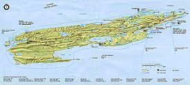
Isle Royale is an island of the Great Lakes, located in the northwest of Lake Superior, and part of the state of Michigan. The island and the 450 surrounding smaller islands and waters make up Isle Royale National Park....
is the second largest island in the Great Lakes
Great Lakes
The Great Lakes are a collection of freshwater lakes located in northeastern North America, on the Canada – United States border. Consisting of Lakes Superior, Michigan, Huron, Erie, and Ontario, they form the largest group of freshwater lakes on Earth by total surface, coming in second by volume...
system, after only Manitoulin Island
Manitoulin Island
Manitoulin Island is a Canadian island in Lake Huron, in the province of Ontario. It is the largest island in a freshwater lake in the world. In addition to the historic Anishinaabe and European settlement of the island, archeological discoveries at Sheguiandah have demonstrated Paleo-Indian and...
in Lake Huron
Lake Huron
Lake Huron is one of the five Great Lakes of North America. Hydrologically, it comprises the larger portion of Lake Michigan-Huron. It is bounded on the east by the Canadian province of Ontario and on the west by the state of Michigan in the United States...
. At 206.7 mi² (535.4 km²), Isle Royale is the third largest island in the contiguous United States
Contiguous United States
The contiguous United States are the 48 U.S. states on the continent of North America that are south of Canada and north of Mexico, plus the District of Columbia....
after Long Island
Long Island
Long Island is an island located in the southeast part of the U.S. state of New York, just east of Manhattan. Stretching northeast into the Atlantic Ocean, Long Island contains four counties, two of which are boroughs of New York City , and two of which are mainly suburban...
and Padre Island
Padre Island
Padre Island is part of the U.S. state of Texas. The island is located on Texas' southern coast of the Gulf of Mexico and is famous for its white sandy beaches at the south end...
. The island and the surrounding islands and waters make up Isle Royale National Park
Isle Royale National Park
Isle Royale National Park is a U.S. National Park in the state of Michigan. Isle Royale, the largest island in Lake Superior, is over 45 miles in length and 9 miles wide at its widest point. The park is made of Isle Royale itself and approximately 400 smaller islands, along with any submerged...
for a total area of 209 sq mi² (542 km²) of above-water territory.
Isle Royale National Park consists of one large island (Isle Royale) surrounded by over 450 smaller islands, although approximately 110 of these islands are formally named. While Isle Royale National Park contains no permanent population and is governed by the National Park Service
National Park Service
The National Park Service is the U.S. federal agency that manages all national parks, many national monuments, and other conservation and historical properties with various title designations...
, the territory itself is part of Keweenaw County
Keweenaw County, Michigan
-Demographics:As of the census of 2000, there were 2,301 people, 998 households, and 604 families residing in the county. The population density was 4 people per square mile . There were 2,327 housing units at an average density of 4 per square mile...
. The northern half of the park is administered locally by Houghton Township
Houghton Township, Michigan
Houghton Township is a civil township of Keweenaw County in the U.S. state of Michigan. The population was 204 at the 2000 census. The township includes a portion of the Keweenaw Peninsula and also the northern half of Isle Royale.-Geography:...
, while the southern half is part of Eagle Harbor Township
Eagle Harbor Township, Michigan
Eagle Harbor Township is a civil township of Keweenaw County in the U.S. state of Michigan. As of the 2000 census, the township population was 281. The irregularly-shaped township is located on the Keweenaw Peninsula and also includes the southern half of Isle Royale...
.
List of islands
| Island | Coordinates |
|---|---|
| Amygdaloid Island Amygdaloid Island Amygdaloid Island is an island in Lake Superior. It is within the boundary of Isle Royale National Park, a national park located within the U.S. state of Michigan. The island is protected and patrolled by a seasonal ranger station operated by the U.S. National Park Service.Amygdaloid Island is... |
48.15111°N 88.62056°W |
| Annie Island | 48.17333°N 88.43833°W |
| Arch Island | 48.06361°N 88.79361°W |
| Bailey Island | 48.15417°N 88.48028°W |
| Barnum Island | 47.87778°N 89.23361°W |
| Bat Island | 48.14639°N 88.46472°W |
| Battleship Island | 48.17472°N 88.49833°W |
| Beaver Island | 47.90778°N 89.17000°W |
| Belle Isle | 48.15250°N 88.58944°W |
| Bobs Island | 48.16778°N 88.45556°W |
| Booth Island | 47.87889°N 89.22611°W |
| Bottle Island | 47.86611°N 89.26639°W |
| Boys Island | 48.18139°N 88.43278°W |
| Burnt Island | 48.09194°N 88.57028°W |
| Burnt Island | 48.09194°N 88.57028°W |
| Captain Kidd Island | 48.16472°N 88.57139°W |
| Castle Island | 47.92250°N 88.82028°W |
| Cemetery Island | 48.09611°N 88.57056°W |
| Center Island | 48.14139°N 88.49167°W |
| Channel Island | 47.97556°N 88.80833°W |
| Chippers Island | 48.15028°N 88.57194°W |
| Clay Island | 48.14472°N 88.59222°W |
| Cork Island | 48.15139°N 88.57667°W |
| Davidson Island | 48.12500°N 88.51389°W |
| Dean Island | 48.15750°N 88.55278°W |
| Diamond Island | 48.16944°N 88.54028°W |
| Dog Island | 48.17972°N 88.43500°W |
| Eagle Island | 48.14972°N 88.57056°W |
| East Caribou Island | 48.10167°N 88.55528°W |
| Edwards Island | 48.17222°N 88.43333°W |
| Emerson Island | 48.16361°N 88.46250°W |
| Fire Island | 48.14111°N 88.51028°W |
| Fisher Island | 48.14944°N 88.52528°W |
| Flag Island | 48.16444°N 88.43111°W |
| Fryett Island | 48.14472°N 88.59778°W |
| Gale Island | 48.16472°N 88.46111°W |
| Glenns Island | 48.16083°N 88.46083°W |
| Grace Island | 47.88139°N 89.21944°W |
| Green Island | 48.16250°N 88.55639°W |
| Green Isle | 48.07000°N 88.77750°W |
| Gull Islands | 48.26222°N 88.26472°W |
| Hat Island | 47.98333°N 88.77306°W |
| Hawk Island | 48.10333°N 88.72556°W |
| Heron Island | 48.12639°N 88.50306°W |
| Hog Island | 48.15778°N 88.47167°W |
| Horn Island | 48.15611°N 88.47639°W |
| Horner Island | 48.14194°N 88.60750°W |
| Howe Island | 48.16500°N 88.45861°W |
| Inner Hill Island | 47.97389°N 88.81917°W |
| Inner Island | 47.97389°N 88.81917°W |
| Isle Royale Isle Royale Isle Royale is an island of the Great Lakes, located in the northwest of Lake Superior, and part of the state of Michigan. The island and the 450 surrounding smaller islands and waters make up Isle Royale National Park.... |
48.00056°N 88.83333°W |
| Johns Island | 47.88889°N 89.24167°W |
| Johnson Island | 48.14806°N 88.58444°W |
| Island | Coordinates |
|---|---|
| Kamloops Island | 48.07556°N 88.78556°W |
| Little Siskiwit Island | 47.94222°N 88.89444°W |
| Lone Tree Island | 48.13750°N 88.49944°W |
| Long Island | 48.17833°N 88.43361°W |
| Long Island | 47.93472°N 88.79944°W |
| Lucky Island | 48.17306°N 88.44333°W |
| Mad Island | 48.12361°N 88.50972°W |
| Malone Island | 47.98056°N 88.79222°W |
| Menagerie Island | 47.94778°N 88.76194°W |
| Merritt Island | 48.18444°N 88.42778°W |
| Middle Islands | 48.09111°N 88.57667°W |
| Minong Island | 48.16361°N 88.45722°W |
| Mott Island | 48.11111°N 88.53556°W |
| Net Island | 48.17361°N 88.54972°W |
| Newman Island | 48.16694°N 88.45778°W |
| North Government Island | 48.17944°N 88.42111°W |
| North Rock | 47.86417°N 89.27639°W |
| Ollies Dogs Rocks | 48.11611°N 88.71556°W |
| Outer Hill Island | 48.11972°N 88.51750°W |
| Outer Island | 47.97222°N 88.81139°W |
| Passage Island Passage Island (Michigan) Passage Island is a small island in the U.S. territory in western Lake Superior. It is the northeastern-most island in Isle Royale National Park. The island is uninhabited, but has a lighthouse and a short hiking trail. The U.S... |
48.23361°N 88.35083°W |
| Paul Islands | 47.91444°N 88.84917°W |
| Pete Island | 48.17417°N 88.47167°W |
| Picnic Island | 48.13583°N 88.51556°W |
| Porter Island | 48.17472°N 88.44417°W |
| Rabbit Island | 48.10028°N 88.56306°W |
| Raspberry Island | 48.14222°N 88.47361°W |
| Redfin Island | 47.90611°N 88.87139°W |
| Ross Island | 47.98056°N 88.77972°W |
| Round Island | 48.12750°N 88.67333°W |
| Salt Island | 47.88611°N 89.21944°W |
| Savage Island | 48.16194°N 88.46611°W |
| Schooner Island | 47.98417°N 88.75583°W |
| Shaw Island | 48.13278°N 88.49694°W |
| Shiverette Island | 47.96500°N 88.83417°W |
| Siskiwit Islands | 47.90806°N 88.86556°W |
| Smith Island | 48.16639°N 88.45222°W |
| Smithwick Island | 48.13667°N 88.48833°W |
| South Government Island | 48.16889°N 88.42333°W |
| Split Island | 48.17750°N 88.42472°W |
| Star Island | 48.12167°N 88.51694°W |
| Steamboat Island | 48.17750°N 88.54250°W |
| Stone House Island | 47.94000°N 88.78417°W |
| Tallman Island | 48.13889°N 88.51111°W |
| Taylor Island | 48.04889°N 88.84583°W |
| Third Island | 48.18250°N 88.42528°W |
| Thompson Island | 47.89194°N 89.23111°W |
| Tookers Island | 48.12917°N 88.50306°W |
| Washington Island Washington Island (Michigan) Washington Island is an uninhabited island in Lake Superior. It is within the boundary of Keweenaw County and Isle Royale National Park, a national park located within the U.S. state of Michigan. It is the westernmost point marked on most maps of the elongated archipelago that makes up this park... |
47.87500°N 89.25000°W |
| West Caribou Island | 48.09639°N 88.56639°W |
| Wheelock Island | 48.15917°N 88.47000°W |
| Wilson Island | 48.05639°N 88.83778°W |
| Wright Island | 47.97056°N 88.82667°W |
Islands within an island
The following five islands are located within inland lakes on the island of Isle RoyaleIsle Royale
Isle Royale is an island of the Great Lakes, located in the northwest of Lake Superior, and part of the state of Michigan. The island and the 450 surrounding smaller islands and waters make up Isle Royale National Park....
. They are by definition islands in lakes.
| Island | Body of water | Coordinates |
|---|---|---|
| Birch Isle | Lake Richie | 48.04917°N 88.69083°W |
| Eagle Nest Island | Siskiwit Lake | 47.99306°N 88.72950°W |
| Hastings Island | Lake Richie | 48.04639°N 88.69417°W |
| Ryan Island | Siskiwit Lake | 48.01000°N 88.77083°W |
| Teakettle Island | Siskiwit Lake | 48.01361°N 88.76333°W |
See also
- Isle RoyaleIsle RoyaleIsle Royale is an island of the Great Lakes, located in the northwest of Lake Superior, and part of the state of Michigan. The island and the 450 surrounding smaller islands and waters make up Isle Royale National Park....
- Isle Royale National ParkIsle Royale National ParkIsle Royale National Park is a U.S. National Park in the state of Michigan. Isle Royale, the largest island in Lake Superior, is over 45 miles in length and 9 miles wide at its widest point. The park is made of Isle Royale itself and approximately 400 smaller islands, along with any submerged...
- Lake SuperiorLake SuperiorLake Superior is the largest of the five traditionally-demarcated Great Lakes of North America. It is bounded to the north by the Canadian province of Ontario and the U.S. state of Minnesota, and to the south by the U.S. states of Wisconsin and Michigan. It is the largest freshwater lake in the...
- List of islands of Michigan