

Irrigation of alluvial fans
Encyclopedia
Irrigation of alluvial fans is the use of water resources, mainly river floods and groundwater
recharged by infiltration of river water, to enhance the production of agricultural crops.
s, also called inland deltas, occur at the foot of mountain ranges and mark the presence of river floods. The rivers flowing at high speed in the mountains carry sediments. Upon losing its speed in the flat land at the foot of the mountain, the water deposits its sediments forming a cone
shaped earth body. The coarse sediments like gravel
and sand
are deposited first, close to the entrance of the river into the plain. The finer sediments, consisting of silt
and clay
, are deposited towards the base of the cone.
Upon entering the plain, and forced by the deposits of the sediments, the river divides itself into numerous branches fanning out towards the plain. The alluvial fans contain considerable groundwater
reservoirs that are replenished each year by infiltration of the water from the river branches into the usually permeable underground thus obtaining rich aquifer
s.
The mountainous areas usually receive more rainfall than the plains: they form a watershed and provide a source of water. In (semi)arid regions, therefore, alluvial fans are often used for irrigation
of agricultural crops. The fans reveal much greenery in the harsh desert
-like environment.
The irrigation methods in alluvial fans differ according to the hydrological
regime of the river, the shape of the fan, and the natural resources available to maintain human life.
Average annual rainfall in Baluchistan varies between 200 and 400 mm, depending on altitude, and the main part occurs in winter (November to March). Of old, in sloping lands, farmers constructed bunds along the contour lines to capture the surface runoff
(Fig. K1). This method of water harvesting (locally called khuskaba) provided extra water for agricultural crops planted just up-slope of the bund, where the captured water would infiltrate into the soil and provide extra soil moisture to supplement the scarce rainfall.
In alluvial fans, the spate floods provided and additional source of water. The floods, diverted from the watercourses, were retained behind similar bunds employed in the khuskaba system (Fig. K2). The method of flood interception is locally called sailaba (Rod Kohi elsewhere in Pakistan, generally: spate irrigation
). The system is combined with the tapping of groundwater
from the aquifer
by means of dug underground galleries, called karez or qanat
(Fig. K3). The karezes make permanent agriculture possible (Fig. K3).
Although the sailaba-and-qanat systems cover about 20% of the agricultural land, their production is more than 40% of the total.
It is a modern development to sink deep wells
in the aquifer of the alluvial fan to exploit the groundwater more effectively than do the traditional karezes. The owners of the wells may be entrepreneurs from elsewhere and the original population runs the risk of losing the karez water when the wells draw the water table down to a deeper depth than that of the karezes so that the these fall dry (Fig K4).
The irrigation system for the Garmsar alluvial fan is quite well developed (Fig. G1, below), to the extent that lined canals have been made and a large belt-canal crosses the fan through its middle.
Roughly, the cropped area occupies 30% of the land each season, while 70% is left fallow. The winter crops are mainly wheat and barley, while the summer crops are cotton and melons. However, the planting of the new crops is done before harvesting the previous crops. Thus, there is a period of overlap during which 60% of the land is under crops. The fallow land is continuously rotated throughout the years, so that there exists no permanent fallow land, except along the fringes at the base of the fan where soil salinization occurs.
An estimated average annual water balance is shown in Fig. G2 (below). It is seen that the storage of irrigation losses in the aquifer
plays an important role. In the dry season
the groundwater
is used for irrigation by pumping from deep wells. A cross-section of the groundwater situation is shown in Fig. G3 (below).
The water rights
are expressed in sang, a measure of continuous flow of about 10 l/s, but in practice it varies from 10 to more than 15 l/s. The water is delivered to about 100 tertiary units (often a village), within which the water is distributed by 12-day rotations amongst the farmers who each are entitled to receive the authorized sangs for a fixed number of hours during each rotation period. The village communities are, at the same time, water-user associations
who take care of the water-distribution
within the tertiary unit and they maintain the tertiary canals.
At present, the distribution of surface irrigation water to the villages is determined by the Garmsar Water Authority on the basis of the water rights and verbal agreements and communications with the water users in the absence of a written manual. The authority also maintains the irrigation canals and structures. The structures are sometimes re-designed to adjust them to verbally communicated needs. The fair distribution of the irrigation water is not an easy job as the average annual river discharge is quite variable in the range of 5 to 20 m3/s (see graph at the right).
The deep tube-wells are privately owned. The drilling of wells is subject to license
. Recently, the licensing has stopped for fear of over-exploitation of the aquifer. It appears that no operational rules are applied to the wells.
In the fringe lands, the water table is shallow because the discharge capacity of the aquifer diminishes here for two reasons: (1) the hydraulic gradient reduces where the sloping alluvial fan reaches the flat desert area, and (2) the thickness and hydraulic conductivity of the aquifer diminishes. The necessary drainage canals for watertable control
at the fringes of the irrigation perimeter are not maintained by the water authority, but by the respective farmers groups. For the irrigation water, these groups depend (1) on occasional river floods too large to be handled by the irrigation system and that flow down to the fringe lands through the natural watercourses, (2) on spillage from the irrigation system, and (3) on deep wells.
To stabilize the agriculture in the fringe lands, which are threatened by soil salinization, a method of strip-cropping (Fig. G4) can be recommended for soil salinity control. This method uses irrigated strips next to permanently un-irrigated strips, whereby the salinization is directed to the un-irrigated strips. This concept is sometimes called sacrificial drainage.
The alluvial fan
of Punata is found in the district of Cochabamba
, Bolivia
.
The region of Punata, at the upper end of the Valle (valley) Alto, at about 2800 m altitude, has a summer rainfall of 400 to 450 mm starting in the second half of November end ending in March. Maize
is here the most important food crop, followed by potatoes. Alfalfa
is the dominant fodder crop, followed by maize straw. (Fig. P1). These crops could, of old, only be planted successfully because of the existence of additional water resources like runoff
, floods, river base-flow and groundwater
. In the winter months, crop growth is restricted due to the occurrence of night frosts, especially in June and July, and absence of rains.
The total rural population in Punata is estimated at 25 000. There are about 4000 families of which an estimated 3680 are farmer families. The farm
s are small. The average size is 1.3 ha of which 1 ha is cropped. The modal size of farm is smaller, about 0.7 ha.
The rainfall distribution in Punata is characterized by a wet season from December to March, a dry season
from May to October, and transition months in April and November. The average yearly total is 428 mm (1966 to 1983, San Benito). The rainfall with a probability of exceedance of 75% (R75) on a year basis is 360 mm. Rainfall is not reliable: in the period from 1966 to 1983, the yearly total varied between 246 mm (1982/83) to 591 mm (1968/69).
The river floods during the rainy summer period can be used for irrigation by anyone who wants to. When the river flow recedes, the stream can only be used for rotational irrigation by those who are entitled to take part in it (this is locally called the mita system). By the month of May the river base-flow becomes strongly reduced, and a drought period sets in, lasting into November.
Irrigation
is considered desirable to start the cropping season in August/September, so that an early harvest
can be obtained. The early harvest has a high market value and reduces peak labor requirements. Further, the irrigation reduces the risk of crop failure and it permits diversification of agricultural
produce. Nevertheless, there are some farming communities that have refrained in the past from the extra effort to obtain additional irrigation water and who seemed to be content with purely rain-fed cropping.
At a modest scale, irrigation from deep-wells is also practiced.
In order to satisfy the needs of the majority of the farmers who strongly wish to have additional irrigation water, the irrigation project Punata-Tiraque began to be developed from 1970 onwards. The project entailed the construction of a complicated system of dam
s and reservoirs up in the Andean mountains
(Fig. P2).
The gross area of the Punata projects is estimated at 4600 ha, 90% of which can be used for agriculture or animal husbandry. About 1150 ha of this presently receive irrigation water, either surface water derived from the Laguna Robada or Lluska Kocha dam, or water pumped from the 16 deep wells in the project area (estimated at 350 ha). In addition there are a few hundred hectares that receive occasional water from mita irrigation (wild flooding).
The traditional irrigation method is based on handling large irrigation flows (golpes) per farm at large intervals. The intake structures in the Pucara Mayu river, at the place where it enters the alluvial fan of Punata, would alternately pass water from each of the reservoir systems (Laguna Robada and Lluska Kocha / Muyu Loma) and the natural mita water. The new system has been designed for smaller flows with shorter rotation intervals, but it works continuously for the whole area, so that there is no need anymore to separate the various sources of water. It covers a much larger area than the traditional system and it incorporates the associations of the mita systems (which may have partly the same members), the associations of tube-well systems (which may also have partly the same members) as well as the persons who had no previous water rights.
Hence, the new irrigation system makes it necessary to replace the traditional water rights by a totally new set of rights (and duties). In addition, the farmers will have to get used to new water distribution methods and new field irrigation techniques. Because the new irrigation zones do not correspond to the boundaries of the existing, scattered, Comité’s de Riego (Fig. P3), not only the water management but also the organizational structure will have to be adjusted to the new situation.
is hand-shaped, with the fingers spread (see map). The Okavango River, which originates in Angola, enters the delta at its apex. On the average, the river carries about 10 000 million m3 of water a year into the delta. The flow rate is high in the months of March and April (about 1000 m3 /s on the average), but varying from year to year between 500 to 1500 m3/s and low in November (100 to 200 m3 /s).
The large volume of water spreading over the delta is almost fully absorbed in permanent and seasonal swamps (the latter are called molapo’s) before is slowly infiltrates or evaporates. There is rich swamp vegetation, which creates an ideal environment for numerous kinds of animals. The rich fauna finds its habitat on and between the thousands of islands between the swamps.
The little water that exceeds the retention capacity of the marsh
y wilderness drains from July to November through the fingers of the giant hand. Hence, it takes almost six months before the peak discharge of the Okavango River manifests itself at the base of the delta. Here, the water meets a barrier: the Thamalakane Fault Line (see map), beyond which the Kalahari sands rise up 10 m. At the foot of the fault, the Thamalakane River collects the water (which is not more than 5% of the total inflow) and carries it almost without gradient to the Boteti River, which flows through a breach in the fault line. Eventually, the remaining waters evaporate
in the Makgadikgadi Pan
s, more than 200 km to the east.
Although the annual rainfall is relatively low (an average of 500 mm, the greater part of which falls from December to March), it contributes a volume of water to the Delta equaling half of the Okavango inflow. The annual rainfall and its yearly distribution are equally erratic as the regime of the river.
 The Okavango River transports a large amount of sand
s and other sediments into the delta. Their mass is about 2 million tons a year. Salts also enter the Delta, but they do so in a dissolved form. The salt concentration of the water is some 200 mg/l, which is very low. The total weight of incoming salts is thus about 2 million tons per year.
The sediments and the salts imported by the Okavango River settle in the delta. Together with the vegetation
the sediments build up resistances to surface-water flow. As a result, the main watercourse
s have in the past swayed from thumb to little finger to and fro, as is common in alluvial fans. Tectonic movements have also contributed to this phenomenon. At present the middle finger, from which the Boro River stems, provides the major thoroughfare.
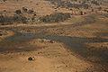
Many of the islands in the delta have a garland of riparian trees along their borders, but in the middle they are bare: symptoms of salt accumulation (see photo of the delta).
The Kalahari Desert cooperates with the Okavango River to form the predominantly sandy soils of the delta. The desert uses the vector wind to deposit its share of fine sand.
The geophysical characteristics of the Okavango Delta have led to a low population density, so that the natural situation has scarcely been disrupted by mankind. Also, the population was more interested in hunting
and cattle breeding than in food crop production, so that agricultural developments were limited.
The arable land
s in the south-eastern fringes of the delta, that become dry after the floods recede (these are locally known as molapo’s), often have a sandy topsoil. In depressions, the topsoil may be thin or missing altogether, exposing a heavy clay
soil.
coincided with an outbreak of foot and mouth disease, leaving the local population in a state of emergency. This resulted in two important undertakings:
The Molapo Development Projects (MDP) became operational in December 1983. The project aimed at increasing crop production in pilot areas by protecting those areas against prolonged high floods by flood-control bunds with entrance gates that could be closed (see photo). When enough floodwater has entered the molapo, the gate can be closed and the water recedes under influence of evaporation
and infiltration
into the soil and cropping may start when the outside water level is still high. This was a response to the high and prolonged flooding in the years 1974-1978, when molapo cropping was largely impossible. In more recent years, however, inadequate floods appeared to present an equally severe constraint to satisfactory crop production. It was therefore decided to focus also on improved, more stable crop production under fully rain-dependent conditions.
The hydrograph figure shows that crop production has not been possible in 60% of the hitherto recorded years because of the prolonged high floods. The figure also shows how flood-control measures can bring about a timely recession of the water level in the molapo. After the flood has been permitted to enter the bunded molapo, the sluice gates are closed. Recession of the water in the bunded molapo then begins under the influence of evaporation and infiltration, and allows a timely planting of the crop (in October or November). The crops use the residual soil moisture (about 100 mm) till the onset of the rainy season at the end of November or the beginning of December. Thus the growing season is prolonged, the moisture availability is increased, and crop production is enhanced. However, the success of the flood-control measures on the crop performance still depends to a great extent on the amount and distribution of the rainfall.
Groundwater
Groundwater is water located beneath the ground surface in soil pore spaces and in the fractures of rock formations. A unit of rock or an unconsolidated deposit is called an aquifer when it can yield a usable quantity of water. The depth at which soil pore spaces or fractures and voids in rock...
recharged by infiltration of river water, to enhance the production of agricultural crops.
- Alluvial fans, when large and flat, are also called inland deltas
General description
Alluvial fanAlluvial fan
An alluvial fan is a fan-shaped deposit formed where a fast flowing stream flattens, slows, and spreads typically at the exit of a canyon onto a flatter plain. A convergence of neighboring alluvial fans into a single apron of deposits against a slope is called a bajada, or compound alluvial...
s, also called inland deltas, occur at the foot of mountain ranges and mark the presence of river floods. The rivers flowing at high speed in the mountains carry sediments. Upon losing its speed in the flat land at the foot of the mountain, the water deposits its sediments forming a cone
Cone (geometry)
A cone is an n-dimensional geometric shape that tapers smoothly from a base to a point called the apex or vertex. Formally, it is the solid figure formed by the locus of all straight line segments that join the apex to the base...
shaped earth body. The coarse sediments like gravel
Gravel
Gravel is composed of unconsolidated rock fragments that have a general particle size range and include size classes from granule- to boulder-sized fragments. Gravel can be sub-categorized into granule and cobble...
and sand
Sand
Sand is a naturally occurring granular material composed of finely divided rock and mineral particles.The composition of sand is highly variable, depending on the local rock sources and conditions, but the most common constituent of sand in inland continental settings and non-tropical coastal...
are deposited first, close to the entrance of the river into the plain. The finer sediments, consisting of silt
Silt
Silt is granular material of a size somewhere between sand and clay whose mineral origin is quartz and feldspar. Silt may occur as a soil or as suspended sediment in a surface water body...
and clay
Clay
Clay is a general term including many combinations of one or more clay minerals with traces of metal oxides and organic matter. Geologic clay deposits are mostly composed of phyllosilicate minerals containing variable amounts of water trapped in the mineral structure.- Formation :Clay minerals...
, are deposited towards the base of the cone.
Upon entering the plain, and forced by the deposits of the sediments, the river divides itself into numerous branches fanning out towards the plain. The alluvial fans contain considerable groundwater
Groundwater
Groundwater is water located beneath the ground surface in soil pore spaces and in the fractures of rock formations. A unit of rock or an unconsolidated deposit is called an aquifer when it can yield a usable quantity of water. The depth at which soil pore spaces or fractures and voids in rock...
reservoirs that are replenished each year by infiltration of the water from the river branches into the usually permeable underground thus obtaining rich aquifer
Aquifer
An aquifer is a wet underground layer of water-bearing permeable rock or unconsolidated materials from which groundwater can be usefully extracted using a water well. The study of water flow in aquifers and the characterization of aquifers is called hydrogeology...
s.
The mountainous areas usually receive more rainfall than the plains: they form a watershed and provide a source of water. In (semi)arid regions, therefore, alluvial fans are often used for irrigation
Surface irrigation
Surface irrigation is defined as the group of application techniques where water is applied and distributed over the soil surface by gravity. It is by far the most common form of irrigation throughout the world and has been practiced in many areas virtually unchanged for thousands of years.Surface...
of agricultural crops. The fans reveal much greenery in the harsh desert
Desert
A desert is a landscape or region that receives an extremely low amount of precipitation, less than enough to support growth of most plants. Most deserts have an average annual precipitation of less than...
-like environment.
The irrigation methods in alluvial fans differ according to the hydrological
Hydrology
Hydrology is the study of the movement, distribution, and quality of water on Earth and other planets, including the hydrologic cycle, water resources and environmental watershed sustainability...
regime of the river, the shape of the fan, and the natural resources available to maintain human life.
Types of fans
The following alluvial fans will be reviewed in increasing order of water yield:- The alluvial fans along the river plains near KhuzdarKhuzdarKhuzdar or Khozdar is a town located in Khuzdar District in Balochistan, Pakistan. Khuzdar is the capital of Khuzdar District, which was created on 1 March 1974...
, Baluchistan, PakistanPakistanPakistan , officially the Islamic Republic of Pakistan is a sovereign state in South Asia. It has a coastline along the Arabian Sea and the Gulf of Oman in the south and is bordered by Afghanistan and Iran in the west, India in the east and China in the far northeast. In the north, Tajikistan...
(Figure 1).
- These fans are fed by small water catchmentsDrainage basinA drainage basin is an extent or an area of land where surface water from rain and melting snow or ice converges to a single point, usually the exit of the basin, where the waters join another waterbody, such as a river, lake, reservoir, estuary, wetland, sea, or ocean...
in areas of relatively low mountains. The fans are relatively small, steep, and subject to flash floods- The alluvial fan of GarmsarGarmsarGarmsar is a city in and the capital of Garmsar County, Semnan Province, Iran. At the 2006 census, its population was 38,891, in 10,951 families....
, east of TehranTehranTehran , sometimes spelled Teheran, is the capital of Iran and Tehran Province. With an estimated population of 8,429,807; it is also Iran's largest urban area and city, one of the largest cities in Western Asia, and is the world's 19th largest city.In the 20th century, Tehran was subject to...
, IranIranIran , officially the Islamic Republic of Iran , is a country in Southern and Western Asia. The name "Iran" has been in use natively since the Sassanian era and came into use internationally in 1935, before which the country was known to the Western world as Persia...
(Figure 2).
- The alluvial fan of Garmsar
- This fairly large fan is fed by the Hableh Rud (river) with an important catchment area in the high Alburz mountain range. The river carries a large amount of water during the rainy season, otherwise the discharge is low.
- The alluvial fan of PunataPunataPunata is the capital of Punata Province and Punata Municipality in Cochabamba Department, Bolivia. At the time of census 2001 it had a population of 14,742 inhabitants...
in the Valle Alto, east of CochabambaCochabambaCochabamba is a city in central Bolivia, located in a valley bearing the same name in the Andes mountain range. It is the capital of the Cochabamba Department and is the fourth largest city in Bolivia with an urban population of 608,276 and a metropolitan population of more than 1,000,000 people...
, BoliviaBoliviaBolivia officially known as Plurinational State of Bolivia , is a landlocked country in central South America. It is the poorest country in South America...
(Figure 3).
- The alluvial fan of Punata
- The fan is fed by The Rio Paracaya river with a higher average discharge than the Hableh Rud river. Consequently the fan is fairly flat.
- The OkavangoOkavango DeltaThe Okavango Delta , in Botswana, is the world's largest inland delta. It is formed where the Okavango River empties onto a swamp in an endorheic basin in the Kalahari Desert, where most of the water is lost to evaporation and transpiration instead of draining into the sea...
inland delta, near MaunMaunMaun is the fifth largest town in Botswana. As of 2001, it had a population of 43,776. It is an eclectic mix of modern buildings and native huts. Maun is the "tourism capital" of Botswana and the administrative centre of Ngamiland district...
, BotswanaBotswanaBotswana, officially the Republic of Botswana , is a landlocked country located in Southern Africa. The citizens are referred to as "Batswana" . Formerly the British protectorate of Bechuanaland, Botswana adopted its new name after becoming independent within the Commonwealth on 30 September 1966...
(Figure 4)
- The Okavango
- The delta receives an enormous amount of river inflow from AngolaAngolaAngola, officially the Republic of Angola , is a country in south-central Africa bordered by Namibia on the south, the Democratic Republic of the Congo on the north, and Zambia on the east; its west coast is on the Atlantic Ocean with Luanda as its capital city...
. Hence, the fan is so large and flat that it is rather called a delta. It takes six months for the peak inflow at the apex to reach the base of the delta.
Khuzdar
Reference: Modern interferences in traditional water resources in BaluchistanAverage annual rainfall in Baluchistan varies between 200 and 400 mm, depending on altitude, and the main part occurs in winter (November to March). Of old, in sloping lands, farmers constructed bunds along the contour lines to capture the surface runoff
Runoff
Run-off or runoff may refer to:* Surface runoff, the flow of water, from rain, snow melt, or other sources, over land* Runoff model , a mathematical model describing the rainfall-runoff relations of a rainfall catchment area or watershed...
(Fig. K1). This method of water harvesting (locally called khuskaba) provided extra water for agricultural crops planted just up-slope of the bund, where the captured water would infiltrate into the soil and provide extra soil moisture to supplement the scarce rainfall.
In alluvial fans, the spate floods provided and additional source of water. The floods, diverted from the watercourses, were retained behind similar bunds employed in the khuskaba system (Fig. K2). The method of flood interception is locally called sailaba (Rod Kohi elsewhere in Pakistan, generally: spate irrigation
Spate irrigation
Spate irrigation uses seasonal floods of rivers, streams, ponds and lakes to fill water storage canals. If irrigation is the manipulation of water for use in growing crops, Spate irrigation is perhaps the most ancient method devised...
). The system is combined with the tapping of groundwater
Groundwater
Groundwater is water located beneath the ground surface in soil pore spaces and in the fractures of rock formations. A unit of rock or an unconsolidated deposit is called an aquifer when it can yield a usable quantity of water. The depth at which soil pore spaces or fractures and voids in rock...
from the aquifer
Aquifer
An aquifer is a wet underground layer of water-bearing permeable rock or unconsolidated materials from which groundwater can be usefully extracted using a water well. The study of water flow in aquifers and the characterization of aquifers is called hydrogeology...
by means of dug underground galleries, called karez or qanat
Qanat
A qanāt is a water management system used to provide a reliable supply of water for human settlements and irrigation in hot, arid and semi-arid climates...
(Fig. K3). The karezes make permanent agriculture possible (Fig. K3).
Although the sailaba-and-qanat systems cover about 20% of the agricultural land, their production is more than 40% of the total.
It is a modern development to sink deep wells
Water well
A water well is an excavation or structure created in the ground by digging, driving, boring or drilling to access groundwater in underground aquifers. The well water is drawn by an electric submersible pump, a trash pump, a vertical turbine pump, a handpump or a mechanical pump...
in the aquifer of the alluvial fan to exploit the groundwater more effectively than do the traditional karezes. The owners of the wells may be entrepreneurs from elsewhere and the original population runs the risk of losing the karez water when the wells draw the water table down to a deeper depth than that of the karezes so that the these fall dry (Fig K4).
Garmsar
Reference: Irrigation, groundwater, drainage and soil salinity control in the alluvial fan of Garmsar'’The irrigation system for the Garmsar alluvial fan is quite well developed (Fig. G1, below), to the extent that lined canals have been made and a large belt-canal crosses the fan through its middle.
Roughly, the cropped area occupies 30% of the land each season, while 70% is left fallow. The winter crops are mainly wheat and barley, while the summer crops are cotton and melons. However, the planting of the new crops is done before harvesting the previous crops. Thus, there is a period of overlap during which 60% of the land is under crops. The fallow land is continuously rotated throughout the years, so that there exists no permanent fallow land, except along the fringes at the base of the fan where soil salinization occurs.
An estimated average annual water balance is shown in Fig. G2 (below). It is seen that the storage of irrigation losses in the aquifer
Aquifer
An aquifer is a wet underground layer of water-bearing permeable rock or unconsolidated materials from which groundwater can be usefully extracted using a water well. The study of water flow in aquifers and the characterization of aquifers is called hydrogeology...
plays an important role. In the dry season
Dry season
The dry season is a term commonly used when describing the weather in the tropics. The weather in the tropics is dominated by the tropical rain belt, which oscillates from the northern to the southern tropics over the course of the year...
the groundwater
Groundwater
Groundwater is water located beneath the ground surface in soil pore spaces and in the fractures of rock formations. A unit of rock or an unconsolidated deposit is called an aquifer when it can yield a usable quantity of water. The depth at which soil pore spaces or fractures and voids in rock...
is used for irrigation by pumping from deep wells. A cross-section of the groundwater situation is shown in Fig. G3 (below).
The water rights
Riparian water rights
Riparian water rights are system for allocating water among those who possess land about its source. It has its origins in English common law...
are expressed in sang, a measure of continuous flow of about 10 l/s, but in practice it varies from 10 to more than 15 l/s. The water is delivered to about 100 tertiary units (often a village), within which the water is distributed by 12-day rotations amongst the farmers who each are entitled to receive the authorized sangs for a fixed number of hours during each rotation period. The village communities are, at the same time, water-user associations
Irrigation district
In the United States an irrigation district is a cooperative, self-governing public corporation set up as a subdivision of the State government, with definite geographic boundaries, organized, and having taxing power to obtain and distribute water for irrigation of lands within the district;...
who take care of the water-distribution
Irrigation management
Irrigation is the artificial exploitation and distribution of water at project level aiming at application of water at field level to agricultural crops in dry areas or in periods of scarce rainfall to assure or improve crop production...
within the tertiary unit and they maintain the tertiary canals.
At present, the distribution of surface irrigation water to the villages is determined by the Garmsar Water Authority on the basis of the water rights and verbal agreements and communications with the water users in the absence of a written manual. The authority also maintains the irrigation canals and structures. The structures are sometimes re-designed to adjust them to verbally communicated needs. The fair distribution of the irrigation water is not an easy job as the average annual river discharge is quite variable in the range of 5 to 20 m3/s (see graph at the right).
The deep tube-wells are privately owned. The drilling of wells is subject to license
License
The verb license or grant licence means to give permission. The noun license or licence refers to that permission as well as to the document recording that permission.A license may be granted by a party to another party as an element of an agreement...
. Recently, the licensing has stopped for fear of over-exploitation of the aquifer. It appears that no operational rules are applied to the wells.
In the fringe lands, the water table is shallow because the discharge capacity of the aquifer diminishes here for two reasons: (1) the hydraulic gradient reduces where the sloping alluvial fan reaches the flat desert area, and (2) the thickness and hydraulic conductivity of the aquifer diminishes. The necessary drainage canals for watertable control
Watertable control
Watertable control is the practice of controlling the water table in agricultural land by subsurface drainage with proper criteria to improve the crop production.- Description and definitions :...
at the fringes of the irrigation perimeter are not maintained by the water authority, but by the respective farmers groups. For the irrigation water, these groups depend (1) on occasional river floods too large to be handled by the irrigation system and that flow down to the fringe lands through the natural watercourses, (2) on spillage from the irrigation system, and (3) on deep wells.
To stabilize the agriculture in the fringe lands, which are threatened by soil salinization, a method of strip-cropping (Fig. G4) can be recommended for soil salinity control. This method uses irrigated strips next to permanently un-irrigated strips, whereby the salinization is directed to the un-irrigated strips. This concept is sometimes called sacrificial drainage.
Punata
Reference: The Punata-Tiraque irrigation project near Cochabamba, BoliviaThe alluvial fan
Alluvial fan
An alluvial fan is a fan-shaped deposit formed where a fast flowing stream flattens, slows, and spreads typically at the exit of a canyon onto a flatter plain. A convergence of neighboring alluvial fans into a single apron of deposits against a slope is called a bajada, or compound alluvial...
of Punata is found in the district of Cochabamba
Cochabamba
Cochabamba is a city in central Bolivia, located in a valley bearing the same name in the Andes mountain range. It is the capital of the Cochabamba Department and is the fourth largest city in Bolivia with an urban population of 608,276 and a metropolitan population of more than 1,000,000 people...
, Bolivia
Bolivia
Bolivia officially known as Plurinational State of Bolivia , is a landlocked country in central South America. It is the poorest country in South America...
.
The region of Punata, at the upper end of the Valle (valley) Alto, at about 2800 m altitude, has a summer rainfall of 400 to 450 mm starting in the second half of November end ending in March. Maize
Maize
Maize known in many English-speaking countries as corn or mielie/mealie, is a grain domesticated by indigenous peoples in Mesoamerica in prehistoric times. The leafy stalk produces ears which contain seeds called kernels. Though technically a grain, maize kernels are used in cooking as a vegetable...
is here the most important food crop, followed by potatoes. Alfalfa
Alfalfa
Alfalfa is a flowering plant in the pea family Fabaceae cultivated as an important forage crop in the US, Canada, Argentina, France, Australia, the Middle East, South Africa, and many other countries. It is known as lucerne in the UK, France, Australia, South Africa and New Zealand, and known as...
is the dominant fodder crop, followed by maize straw. (Fig. P1). These crops could, of old, only be planted successfully because of the existence of additional water resources like runoff
Surface runoff
Surface runoff is the water flow that occurs when soil is infiltrated to full capacity and excess water from rain, meltwater, or other sources flows over the land. This is a major component of the water cycle. Runoff that occurs on surfaces before reaching a channel is also called a nonpoint source...
, floods, river base-flow and groundwater
Groundwater
Groundwater is water located beneath the ground surface in soil pore spaces and in the fractures of rock formations. A unit of rock or an unconsolidated deposit is called an aquifer when it can yield a usable quantity of water. The depth at which soil pore spaces or fractures and voids in rock...
. In the winter months, crop growth is restricted due to the occurrence of night frosts, especially in June and July, and absence of rains.
The total rural population in Punata is estimated at 25 000. There are about 4000 families of which an estimated 3680 are farmer families. The farm
Farm
A farm is an area of land, or, for aquaculture, lake, river or sea, including various structures, devoted primarily to the practice of producing and managing food , fibres and, increasingly, fuel. It is the basic production facility in food production. Farms may be owned and operated by a single...
s are small. The average size is 1.3 ha of which 1 ha is cropped. The modal size of farm is smaller, about 0.7 ha.
The rainfall distribution in Punata is characterized by a wet season from December to March, a dry season
Dry season
The dry season is a term commonly used when describing the weather in the tropics. The weather in the tropics is dominated by the tropical rain belt, which oscillates from the northern to the southern tropics over the course of the year...
from May to October, and transition months in April and November. The average yearly total is 428 mm (1966 to 1983, San Benito). The rainfall with a probability of exceedance of 75% (R75) on a year basis is 360 mm. Rainfall is not reliable: in the period from 1966 to 1983, the yearly total varied between 246 mm (1982/83) to 591 mm (1968/69).
The river floods during the rainy summer period can be used for irrigation by anyone who wants to. When the river flow recedes, the stream can only be used for rotational irrigation by those who are entitled to take part in it (this is locally called the mita system). By the month of May the river base-flow becomes strongly reduced, and a drought period sets in, lasting into November.
Irrigation
Surface irrigation
Surface irrigation is defined as the group of application techniques where water is applied and distributed over the soil surface by gravity. It is by far the most common form of irrigation throughout the world and has been practiced in many areas virtually unchanged for thousands of years.Surface...
is considered desirable to start the cropping season in August/September, so that an early harvest
Harvest
Harvest is the process of gathering mature crops from the fields. Reaping is the cutting of grain or pulse for harvest, typically using a scythe, sickle, or reaper...
can be obtained. The early harvest has a high market value and reduces peak labor requirements. Further, the irrigation reduces the risk of crop failure and it permits diversification of agricultural
Agriculture
Agriculture is the cultivation of animals, plants, fungi and other life forms for food, fiber, and other products used to sustain life. Agriculture was the key implement in the rise of sedentary human civilization, whereby farming of domesticated species created food surpluses that nurtured the...
produce. Nevertheless, there are some farming communities that have refrained in the past from the extra effort to obtain additional irrigation water and who seemed to be content with purely rain-fed cropping.
At a modest scale, irrigation from deep-wells is also practiced.
In order to satisfy the needs of the majority of the farmers who strongly wish to have additional irrigation water, the irrigation project Punata-Tiraque began to be developed from 1970 onwards. The project entailed the construction of a complicated system of dam
Dam
A dam is a barrier that impounds water or underground streams. Dams generally serve the primary purpose of retaining water, while other structures such as floodgates or levees are used to manage or prevent water flow into specific land regions. Hydropower and pumped-storage hydroelectricity are...
s and reservoirs up in the Andean mountains
Andes
The Andes is the world's longest continental mountain range. It is a continual range of highlands along the western coast of South America. This range is about long, about to wide , and of an average height of about .Along its length, the Andes is split into several ranges, which are separated...
(Fig. P2).
The gross area of the Punata projects is estimated at 4600 ha, 90% of which can be used for agriculture or animal husbandry. About 1150 ha of this presently receive irrigation water, either surface water derived from the Laguna Robada or Lluska Kocha dam, or water pumped from the 16 deep wells in the project area (estimated at 350 ha). In addition there are a few hundred hectares that receive occasional water from mita irrigation (wild flooding).
The traditional irrigation method is based on handling large irrigation flows (golpes) per farm at large intervals. The intake structures in the Pucara Mayu river, at the place where it enters the alluvial fan of Punata, would alternately pass water from each of the reservoir systems (Laguna Robada and Lluska Kocha / Muyu Loma) and the natural mita water. The new system has been designed for smaller flows with shorter rotation intervals, but it works continuously for the whole area, so that there is no need anymore to separate the various sources of water. It covers a much larger area than the traditional system and it incorporates the associations of the mita systems (which may have partly the same members), the associations of tube-well systems (which may also have partly the same members) as well as the persons who had no previous water rights.
Hence, the new irrigation system makes it necessary to replace the traditional water rights by a totally new set of rights (and duties). In addition, the farmers will have to get used to new water distribution methods and new field irrigation techniques. Because the new irrigation zones do not correspond to the boundaries of the existing, scattered, Comité’s de Riego (Fig. P3), not only the water management but also the organizational structure will have to be adjusted to the new situation.
Okavango
Reference: Flood-recession cropping in the molapo's of the Okavango Inland Delta, BotswanaFeatures
The inland Okavango Delta in northwest BotswanaBotswana
Botswana, officially the Republic of Botswana , is a landlocked country located in Southern Africa. The citizens are referred to as "Batswana" . Formerly the British protectorate of Bechuanaland, Botswana adopted its new name after becoming independent within the Commonwealth on 30 September 1966...
is hand-shaped, with the fingers spread (see map). The Okavango River, which originates in Angola, enters the delta at its apex. On the average, the river carries about 10 000 million m3 of water a year into the delta. The flow rate is high in the months of March and April (about 1000 m3 /s on the average), but varying from year to year between 500 to 1500 m3/s and low in November (100 to 200 m3 /s).
The large volume of water spreading over the delta is almost fully absorbed in permanent and seasonal swamps (the latter are called molapo’s) before is slowly infiltrates or evaporates. There is rich swamp vegetation, which creates an ideal environment for numerous kinds of animals. The rich fauna finds its habitat on and between the thousands of islands between the swamps.
The little water that exceeds the retention capacity of the marsh
Marsh
In geography, a marsh, or morass, is a type of wetland that is subject to frequent or continuous flood. Typically the water is shallow and features grasses, rushes, reeds, typhas, sedges, other herbaceous plants, and moss....
y wilderness drains from July to November through the fingers of the giant hand. Hence, it takes almost six months before the peak discharge of the Okavango River manifests itself at the base of the delta. Here, the water meets a barrier: the Thamalakane Fault Line (see map), beyond which the Kalahari sands rise up 10 m. At the foot of the fault, the Thamalakane River collects the water (which is not more than 5% of the total inflow) and carries it almost without gradient to the Boteti River, which flows through a breach in the fault line. Eventually, the remaining waters evaporate
Evaporation
Evaporation is a type of vaporization of a liquid that occurs only on the surface of a liquid. The other type of vaporization is boiling, which, instead, occurs on the entire mass of the liquid....
in the Makgadikgadi Pan
Makgadikgadi Pan
The Makgadikgadi Pan is a large salt pan in the middle of the dry savanna of northeastern Botswana. It is one of the largest salt flats in the world...
s, more than 200 km to the east.
Although the annual rainfall is relatively low (an average of 500 mm, the greater part of which falls from December to March), it contributes a volume of water to the Delta equaling half of the Okavango inflow. The annual rainfall and its yearly distribution are equally erratic as the regime of the river.
Sand
Sand is a naturally occurring granular material composed of finely divided rock and mineral particles.The composition of sand is highly variable, depending on the local rock sources and conditions, but the most common constituent of sand in inland continental settings and non-tropical coastal...
s and other sediments into the delta. Their mass is about 2 million tons a year. Salts also enter the Delta, but they do so in a dissolved form. The salt concentration of the water is some 200 mg/l, which is very low. The total weight of incoming salts is thus about 2 million tons per year.
The sediments and the salts imported by the Okavango River settle in the delta. Together with the vegetation
Vegetation
Vegetation is a general term for the plant life of a region; it refers to the ground cover provided by plants. It is a general term, without specific reference to particular taxa, life forms, structure, spatial extent, or any other specific botanical or geographic characteristics. It is broader...
the sediments build up resistances to surface-water flow. As a result, the main watercourse
Watercourse
A watercourse is any flowing body of water. These include rivers, streams, anabranches, and so forth.-See also:* physical geography* Environmental flow* Waterway* Hydrology* Wadi-External links:...
s have in the past swayed from thumb to little finger to and fro, as is common in alluvial fans. Tectonic movements have also contributed to this phenomenon. At present the middle finger, from which the Boro River stems, provides the major thoroughfare.
Many of the islands in the delta have a garland of riparian trees along their borders, but in the middle they are bare: symptoms of salt accumulation (see photo of the delta).
The Kalahari Desert cooperates with the Okavango River to form the predominantly sandy soils of the delta. The desert uses the vector wind to deposit its share of fine sand.
The geophysical characteristics of the Okavango Delta have led to a low population density, so that the natural situation has scarcely been disrupted by mankind. Also, the population was more interested in hunting
Hunting
Hunting is the practice of pursuing any living thing, usually wildlife, for food, recreation, or trade. In present-day use, the term refers to lawful hunting, as distinguished from poaching, which is the killing, trapping or capture of the hunted species contrary to applicable law...
and cattle breeding than in food crop production, so that agricultural developments were limited.
The arable land
Arable land
In geography and agriculture, arable land is land that can be used for growing crops. It includes all land under temporary crops , temporary meadows for mowing or pasture, land under market and kitchen gardens and land temporarily fallow...
s in the south-eastern fringes of the delta, that become dry after the floods recede (these are locally known as molapo’s), often have a sandy topsoil. In depressions, the topsoil may be thin or missing altogether, exposing a heavy clay
Clay
Clay is a general term including many combinations of one or more clay minerals with traces of metal oxides and organic matter. Geologic clay deposits are mostly composed of phyllosilicate minerals containing variable amounts of water trapped in the mineral structure.- Formation :Clay minerals...
soil.
Developments
In 1978/79, after four years of high and prolonged floods had made molapo farming impossible, a severe droughtDrought
A drought is an extended period of months or years when a region notes a deficiency in its water supply. Generally, this occurs when a region receives consistently below average precipitation. It can have a substantial impact on the ecosystem and agriculture of the affected region...
coincided with an outbreak of foot and mouth disease, leaving the local population in a state of emergency. This resulted in two important undertakings:
- The first took place from 1979 to 1981 when, as part of a drought-relief program (Food for Work), FAO organized labor-intensive works to rehabilitate the flood-control bunds that the local population had built to protect their crops against inundations from rainstorms. Some new bunds were also built.
- The second was the construction of the “Buffalo-fence” (see map), which separates the outer fringes of the delta from its interior to prevent the spread of cattle diseases – especially foot and mouth disease. Completed in 1983, this fence has increased the importance of the molapo’s outside it, and for the following reasons. Especially in the years when rains start late, the new grass flush in the molapo’s after flood-recession presents about the only source of fodderFodderFodder or animal feed is any agricultural foodstuff used specifically to feed domesticated livestock such as cattle, goats, sheep, horses, chickens and pigs. Most animal feed is from plants but some is of animal origin...
in the region, also for the herdHerdHerd refers to a social grouping of certain animals of the same species, either wild or domestic, and also to the form of collective animal behavior associated with this or as a verb, to herd, to its control by another species such as humans or dogs.The term herd is generally applied to mammals,...
s in the wide surroundings of the delta. With the molapo’s inside the fence closed to cattle grazingGrazingGrazing generally describes a type of feeding, in which a herbivore feeds on plants , and also on other multicellular autotrophs...
, the grazing intensity in the molapo’s outside the fence has increased.
The Molapo Development Projects (MDP) became operational in December 1983. The project aimed at increasing crop production in pilot areas by protecting those areas against prolonged high floods by flood-control bunds with entrance gates that could be closed (see photo). When enough floodwater has entered the molapo, the gate can be closed and the water recedes under influence of evaporation
Evaporation
Evaporation is a type of vaporization of a liquid that occurs only on the surface of a liquid. The other type of vaporization is boiling, which, instead, occurs on the entire mass of the liquid....
and infiltration
Infiltration
Infiltration may refer to:*Infiltration , a heating, ventilation, and air conditioning term for air leakage into buildings*Infiltration , downward movement of water through soil...
into the soil and cropping may start when the outside water level is still high. This was a response to the high and prolonged flooding in the years 1974-1978, when molapo cropping was largely impossible. In more recent years, however, inadequate floods appeared to present an equally severe constraint to satisfactory crop production. It was therefore decided to focus also on improved, more stable crop production under fully rain-dependent conditions.
The hydrograph figure shows that crop production has not been possible in 60% of the hitherto recorded years because of the prolonged high floods. The figure also shows how flood-control measures can bring about a timely recession of the water level in the molapo. After the flood has been permitted to enter the bunded molapo, the sluice gates are closed. Recession of the water in the bunded molapo then begins under the influence of evaporation and infiltration, and allows a timely planting of the crop (in October or November). The crops use the residual soil moisture (about 100 mm) till the onset of the rainy season at the end of November or the beginning of December. Thus the growing season is prolonged, the moisture availability is increased, and crop production is enhanced. However, the success of the flood-control measures on the crop performance still depends to a great extent on the amount and distribution of the rainfall.