

Iran-Iraq border
Encyclopedia
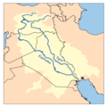
The Iran-Iraq boundary runs for 1,458 kilometers, from the Shatt al-Arab (known as Arvand Rud in Iran) waterway to the tripoint boundary with modern Turkey
at the Kuh e-Dalanper. Although the boundary was first determined in 1639, certain disputes fester, particularly disputes surrounding navigation on the Shatt al-Arab waterway. The currently binding treaty, the Algiers Agreement (1975)
has been in force since signed by both nations in 1975 and ratified by both nations in 1976.
 The boundary begins in the Persian Gulf
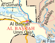
at the "lowest point of low water" at the mouth of the Shatt al-Arab at 29°51′16"N 48°44′45"E (WGS84.) It then closely follows the thalweg
of the Shatt al-Arab for some 105 kilometers in a series of short straight line segments, reaching the confluence of the Shatt al-Arab and the Nahr al-Khayin tributary. From there it winds northward, following a series of boundary markers across plain and hill, through the Zagros Mountains
Nahr at-Tib, and Nahr Wadi. It meets the boundary with Turkey at 37° 08' 44" N and 44° 47' 05" E.
between the Ottoman Empire
, which controlled Iraq, and Persia. The agreement stipulated that the boundary would run between the Zagros Mountains and the Tigris River. In 1724, the Ottomans rejected the boundary-line and invaded Persia, but when peace was finally concluded in 1746, the two states recognized the 1639 boundary as official. This was affirmed by the 1847 Treaty of Erzerum, however, the new treaty first raised the issue of the Shatt al-Arab waterway. The boundary was set at the eastern bank of the Persian gulf, so that the entire waterway remained under Turkish (i.e., Iraq
i) control. In the following years, the boundary-line was further delineated, and a detailed map
was produced in 1860.
 A more precise demarcation was begun in 1911 at the urging of Russia
and Great Britain
, both of whom had colonial
aspirations in the region. In 1913-1914, a commission established by the Constantinople Protocol set the revised boundary, with control of the Shatt al-Arab going to Turkey. In general, the line was to follow the east bank of the waterway, except in the region surrounding the Persian town of Khorramshahr
, where it was to follow the thalweg.
This was challenged by Iran
in 1934, as the validity of both the Treaty of Erzurum and the Istanbul Protocol was called into question. The dispute was resolved in 1937, following the general lines of the old boundary, with the exception of the area immediately around the Iranian town of Abadan, where the boundary was moved from the east bank to the thalweg, as had been done around Khorramshahr two decades earlier.
While this resolved Iran's major grievances, it failed to respond to the issue of freedom of navigation in the Shatt al-Arab. This was resolved in 1975, when Iran and Iraq signed an agreement in Algiers
in which the thalweg was determined to be the boundary throughout the Shatt al-Arab waterway. In return, Iran promised to cease its support for Kurdish rebels in northern Iraq. The new treaty was rejected by Iraq five years later, and was a cause of the Iran-Iraq war
. Iraq finally accepted the new boundary in 1990 following its failed invasion of Kuwait, in accordance with United Nations
Resolution 598.
regarding its boundary with Iran. Under international law, a bilateral or multilateral treaty cannot be abrogated by one party and one party only, and thus various statements to that effect about this agreement have had no legal effect. In 2004 and again in March, 2007, the boundary question rose to international prominence when Iranian soldiers seized British sailors
operating in the vicinity of the Shatt al-Arab, in what Iran alleged were its own territorial waters.
Turkey
Turkey , known officially as the Republic of Turkey , is a Eurasian country located in Western Asia and in East Thrace in Southeastern Europe...
at the Kuh e-Dalanper. Although the boundary was first determined in 1639, certain disputes fester, particularly disputes surrounding navigation on the Shatt al-Arab waterway. The currently binding treaty, the Algiers Agreement (1975)
Algiers Agreement (1975)
The 1975 Algiers Agreement was an agreement between Iran and Iraq to settle their border disputes , and served as basis for the bilateral treaties signed on 13 June and 26 December 1975...
has been in force since signed by both nations in 1975 and ratified by both nations in 1976.
Boundary line
Persian Gulf
The Persian Gulf, in Southwest Asia, is an extension of the Indian Ocean located between Iran and the Arabian Peninsula.The Persian Gulf was the focus of the 1980–1988 Iran-Iraq War, in which each side attacked the other's oil tankers...
at the "lowest point of low water" at the mouth of the Shatt al-Arab at 29°51′16"N 48°44′45"E (WGS84.) It then closely follows the thalweg
Thalweg
Thalweg in geography and fluvial geomorphology signifies the deepest continuous inline within a valley or watercourse system.-Hydrology:In hydrological and fluvial landforms, the thalweg is a line drawn to join the lowest points along the entire length of a stream bed or valley in its downward...
of the Shatt al-Arab for some 105 kilometers in a series of short straight line segments, reaching the confluence of the Shatt al-Arab and the Nahr al-Khayin tributary. From there it winds northward, following a series of boundary markers across plain and hill, through the Zagros Mountains
Zagros Mountains
The Zagros Mountains are the largest mountain range in Iran and Iraq. With a total length of 1,500 km , from northwestern Iran, and roughly correlating with Iran's western border, the Zagros range spans the whole length of the western and southwestern Iranian plateau and ends at the Strait of...
Nahr at-Tib, and Nahr Wadi. It meets the boundary with Turkey at 37° 08' 44" N and 44° 47' 05" E.
History
The boundary dates back to the 1639 Zuhab TreatyTreaty of Zuhab
The Treaty of Zuhab was an accord signed between Safavid Empire and the Ottoman Empire on May 17, 1639. The accord ended the war that had begun in 1623 and was the last conflict in almost 150 years of intermittent wars between the two states over territorial disputes...
between the Ottoman Empire
Ottoman Empire
The Ottoman EmpireIt was usually referred to as the "Ottoman Empire", the "Turkish Empire", the "Ottoman Caliphate" or more commonly "Turkey" by its contemporaries...
, which controlled Iraq, and Persia. The agreement stipulated that the boundary would run between the Zagros Mountains and the Tigris River. In 1724, the Ottomans rejected the boundary-line and invaded Persia, but when peace was finally concluded in 1746, the two states recognized the 1639 boundary as official. This was affirmed by the 1847 Treaty of Erzerum, however, the new treaty first raised the issue of the Shatt al-Arab waterway. The boundary was set at the eastern bank of the Persian gulf, so that the entire waterway remained under Turkish (i.e., Iraq
Iraq
Iraq ; officially the Republic of Iraq is a country in Western Asia spanning most of the northwestern end of the Zagros mountain range, the eastern part of the Syrian Desert and the northern part of the Arabian Desert....
i) control. In the following years, the boundary-line was further delineated, and a detailed map
Map
A map is a visual representation of an area—a symbolic depiction highlighting relationships between elements of that space such as objects, regions, and themes....
was produced in 1860.
Russia
Russia or , officially known as both Russia and the Russian Federation , is a country in northern Eurasia. It is a federal semi-presidential republic, comprising 83 federal subjects...
and Great Britain
Great Britain
Great Britain or Britain is an island situated to the northwest of Continental Europe. It is the ninth largest island in the world, and the largest European island, as well as the largest of the British Isles...
, both of whom had colonial
Colonialism
Colonialism is the establishment, maintenance, acquisition and expansion of colonies in one territory by people from another territory. It is a process whereby the metropole claims sovereignty over the colony and the social structure, government, and economics of the colony are changed by...
aspirations in the region. In 1913-1914, a commission established by the Constantinople Protocol set the revised boundary, with control of the Shatt al-Arab going to Turkey. In general, the line was to follow the east bank of the waterway, except in the region surrounding the Persian town of Khorramshahr
Khorramshahr
Khorramshahr is a city in and the capital of Khorramshahr County, Khuzestan Province, Iran. At the 2006 census, its population was 123,866, in 26,385 families.Khorramshahr is a port city located approximately north of Abadan...
, where it was to follow the thalweg.
This was challenged by Iran
Iran
Iran , officially the Islamic Republic of Iran , is a country in Southern and Western Asia. The name "Iran" has been in use natively since the Sassanian era and came into use internationally in 1935, before which the country was known to the Western world as Persia...
in 1934, as the validity of both the Treaty of Erzurum and the Istanbul Protocol was called into question. The dispute was resolved in 1937, following the general lines of the old boundary, with the exception of the area immediately around the Iranian town of Abadan, where the boundary was moved from the east bank to the thalweg, as had been done around Khorramshahr two decades earlier.
While this resolved Iran's major grievances, it failed to respond to the issue of freedom of navigation in the Shatt al-Arab. This was resolved in 1975, when Iran and Iraq signed an agreement in Algiers
Algiers
' is the capital and largest city of Algeria. According to the 1998 census, the population of the city proper was 1,519,570 and that of the urban agglomeration was 2,135,630. In 2009, the population was about 3,500,000...
in which the thalweg was determined to be the boundary throughout the Shatt al-Arab waterway. In return, Iran promised to cease its support for Kurdish rebels in northern Iraq. The new treaty was rejected by Iraq five years later, and was a cause of the Iran-Iraq war
Iran-Iraq War
The Iran–Iraq War was an armed conflict between the armed forces of Iraq and Iran, lasting from September 1980 to August 1988, making it the longest conventional war of the twentieth century...
. Iraq finally accepted the new boundary in 1990 following its failed invasion of Kuwait, in accordance with United Nations
United Nations
The United Nations is an international organization whose stated aims are facilitating cooperation in international law, international security, economic development, social progress, human rights, and achievement of world peace...
Resolution 598.
Today
Although Iraq accepted Resolution 598, it continues to question the validity of the Algiers Agreement (1975)Algiers Agreement (1975)
The 1975 Algiers Agreement was an agreement between Iran and Iraq to settle their border disputes , and served as basis for the bilateral treaties signed on 13 June and 26 December 1975...
regarding its boundary with Iran. Under international law, a bilateral or multilateral treaty cannot be abrogated by one party and one party only, and thus various statements to that effect about this agreement have had no legal effect. In 2004 and again in March, 2007, the boundary question rose to international prominence when Iranian soldiers seized British sailors
2007 Iranian seizure of Royal Navy personnel
Iranian military personnel seized 15 Royal Navy personnel during 2007 and held them for 13 days. On 23 March 2007, 15 British Royal Navy personnel, from HMS Cornwall, searching a merchant vessel were surrounded by the Navy of the Iranian Revolutionary Guards and subsequently detained off the...
operating in the vicinity of the Shatt al-Arab, in what Iran alleged were its own territorial waters.