
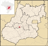
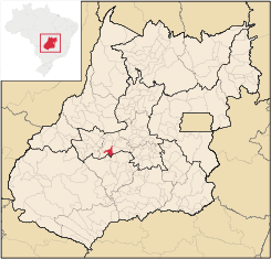
Firminópolis
Encyclopedia
| Firminópolis | |
|---|---|
| State | Goiás Goiás Goiás is a state of Brazil, located in the central part of the country. The name Goiás comes from the name of an indigenous community... |
| Area: | 407.5 km² |
| Population: | 10,286 (IBGE 2007) |
| Population Density; | 25.33 inhab/km² (2007) |
| Elevation: | 685 m above sea level |
| Postcode (CEP): | 76105-000 |
| IBGE statistical microregion: | Anicuns Microregion Anicuns Microregion The Anicuns Microregion is a geographical division in the state of Goiás, Brazil. It is made up of 13 municipalities located near Anicuns, a small city and municipality west of Goiânia... |
| Became a city: | 1948 |
| Distance to Goiânia Goiânia -Climate:The city has a tropical wet and dry climate with an average temperature of . There's a wet season, from October to April, and a dry one, from May to September. Annual rainfall is around 1,520 mm.... : |
126 km. |
| Website: | none |
| Geographical coordinates: | 16°34′56"S 50°18′06"W |
Town
A town is a human settlement larger than a village but smaller than a city. The size a settlement must be in order to be called a "town" varies considerably in different parts of the world, so that, for example, many American "small towns" seem to British people to be no more than villages, while...
and municipality
Municipality
A municipality is essentially an urban administrative division having corporate status and usually powers of self-government. It can also be used to mean the governing body of a municipality. A municipality is a general-purpose administrative subdivision, as opposed to a special-purpose district...
in eastern Goiás
Goiás
Goiás is a state of Brazil, located in the central part of the country. The name Goiás comes from the name of an indigenous community...
state, Brazil
Brazil
Brazil , officially the Federative Republic of Brazil , is the largest country in South America. It is the world's fifth largest country, both by geographical area and by population with over 192 million people...
.
Location and connections
- Distance to São Luís de Montes BelosSão Luís de Montes BelosSão Luís de Montes Belos is a small city and municipality in the State of Goiás, Brazil.-Location:It is located in the Anicuns Microregion, 123 kilometers from the state capital, Goiânia, to which it is connected by highway GO-060...
: 9 km.
Highway connections with Goiânia are made by state highway BR-069 west from Goiânia
Goiânia
-Climate:The city has a tropical wet and dry climate with an average temperature of . There's a wet season, from October to April, and a dry one, from May to September. Annual rainfall is around 1,520 mm....
, through Trindade
Trindade
-Transportation:Trindade are linked with São Tomé and Príncipe's only highways linking to the capital city of São Tomé, another linking Neves and Santana and another linking to Guadalupe as well....
, Santa Bárbara de Goiás
Santa Bárbara de Goiás
Santa Bárbara de Goiás is a small town and municipality in eastern Goiás state, Brazil.-Location:Santa Bárbara is located due west of Goiânia. Nearby towns are Trindade , and Nazário is 25 km...
, Turvânia
Turvânia
Turvânia is a small town and municipality in eastern Goiás state, Brazil.-Location:Turvânia is located west of Goiânia, east of São Luís de Montes Belos....
, and then 19 kilometers west to Firminópolis. Neighboring municipalities are Turvânia
Turvânia
Turvânia is a small town and municipality in eastern Goiás state, Brazil.-Location:Turvânia is located west of Goiânia, east of São Luís de Montes Belos....
, Aurilândia
Aurilândia
Aurilândia is a small town and municipality in eastern Goiás state, Brazil.-Location:The distance to the state capital is 146 km. while the distance to the main regional center São Luís de Montes Belos is 23 km....
, and Turvânia
Turvânia
Turvânia is a small town and municipality in eastern Goiás state, Brazil.-Location:Turvânia is located west of Goiânia, east of São Luís de Montes Belos....
.
Demographic data
- Population growth rate 2000/2007: 0.53%
- Urban population in 2007: 8,212
- Rural population in 2007: 2,074
Economic data
The main economic activities were small transformation industries, goods and services, and agricultural production. There were 02 banking institutions: Banco do Brasil S.A. - Banco Itaú S.A. (08/2007) There was 01 dairy: Manoel Pereira Peixoto (05/2006). The cattle herd had 55,0000 head (2006) and the main crops were rice, corn, soybeans, manioc, hearts of palm, and bananas.Education and health
- Literacy rate: 84.1%
- Infant mortality rate: 18.35 in 1,000 live births
- Schools: 08 (2006)
- Students: 2,382
- Hospitals: 03 (2007) with 69 beds.
- MHDI: 0.744
- State ranking: 91 (out of 242 municipalities in 2002)
- National ranking: 2,039 (out of 5,507 municipalities in 2002)
For the complete list see frigoletto.com.br.
See also
- List of municipalities in Goiás
- Microregions of Goiás