
Israelândia
Encyclopedia
| Israelândia | |
|---|---|
| State | Goiás Goiás Goiás is a state of Brazil, located in the central part of the country. The name Goiás comes from the name of an indigenous community... |
| Area: | 577.4 km² (10/10/2002) |
| Population: | 2,827 (IBGE 2007) |
| Population density: | 4.90 inhab/km² (2007) |
| Elevation: | 378m above sea level |
| Postcode (CEP): | 76205-000 |
| Became a city: | 1958 |
| Mayor: | Débora Liz da Silva e Sousa (January 2005) |
| IBGE statistical Microregion: | Iporá Microregion Iporá Microregion The Iporá Microregion is a geographical region in central-western Goiás state, Brazil. The most important city is Iporá. For a map see -Important Data :*Population: 58,845 *Cities: 10*Total Area: 7,096.60 km²... |
| Distance to Goiânia Goiânia -Climate:The city has a tropical wet and dry climate with an average temperature of . There's a wet season, from October to April, and a dry one, from May to September. Annual rainfall is around 1,520 mm.... : |
199 km. |
| Website: | none (March 2008) |
| Coordinates: | 16°19′32"S 50°53′58"W |
Town
A town is a human settlement larger than a village but smaller than a city. The size a settlement must be in order to be called a "town" varies considerably in different parts of the world, so that, for example, many American "small towns" seem to British people to be no more than villages, while...
and municipality
Municipality
A municipality is essentially an urban administrative division having corporate status and usually powers of self-government. It can also be used to mean the governing body of a municipality. A municipality is a general-purpose administrative subdivision, as opposed to a special-purpose district...
in eastern Goiás
Goiás
Goiás is a state of Brazil, located in the central part of the country. The name Goiás comes from the name of an indigenous community...
state, Brazil
Brazil
Brazil , officially the Federative Republic of Brazil , is the largest country in South America. It is the world's fifth largest country, both by geographical area and by population with over 192 million people...
.
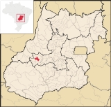
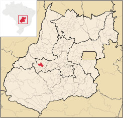
Location
Israelândia is located in the Iporá MicroregionIporá Microregion
The Iporá Microregion is a geographical region in central-western Goiás state, Brazil. The most important city is Iporá. For a map see -Important Data :*Population: 58,845 *Cities: 10*Total Area: 7,096.60 km²...
, 28 km. northeast of regional center Iporá
Iporá
Iporá is a small city and municipality in west-central Goiás state, Brazil. The population was 31,060 in a total area of 1,026.4 km² . It is known as the City of the Clear Waters because of its many streams and rivers.-Location:...
. State capital Goiânia
Goiânia
-Climate:The city has a tropical wet and dry climate with an average temperature of . There's a wet season, from October to April, and a dry one, from May to September. Annual rainfall is around 1,520 mm....
is 199 km. to the east. The Rio Claro, a tributary of the Rio Araguaia, flows through the municipality.
Highway connections with Goiânia are made by taking state highway BR-069 west from Goiânia
Goiânia
-Climate:The city has a tropical wet and dry climate with an average temperature of . There's a wet season, from October to April, and a dry one, from May to September. Annual rainfall is around 1,520 mm....
, through Trindade
Trindade, Goiás
Trindade is a city and municipality in Goiás state, Brazil. It is famous for the religious celebrations held there in July and is now the third most important pilgrimage site in Brazil....
, São Luís de Montes Belos
São Luís de Montes Belos
São Luís de Montes Belos is a small city and municipality in the State of Goiás, Brazil.-Location:It is located in the Anicuns Microregion, 123 kilometers from the state capital, Goiânia, to which it is connected by highway GO-060...
, and then 31 kilometers northeast to Amorinópolis. Neighboring municipalities: Jaupaci
Jaupaci
Jaupaci is a small town and municipality in eastern Goiás state, Brazil. The population was 2,998 in a total area of 527.2 km² .-Location:*Distance to regional center : 46 km....
, Fazenda Nova
Fazenda Nova
Fazenda Nova is a small town and municipality in central-west Goiás state, Brazil.-Location:Fazenda Nova is located northwest of the state capital, Goiânia, which is 206 km. away taking highways GO-418 and GO-060...
, Moiporá
Moiporá
Moiporá is a small town and municipality in eastern Goiás state, Brazil.-Distances and Highway Connections:*Distance to the state capital: 160 km.*Distance to regional center : 76 km....
, and Iporá
Iporá
Iporá is a small city and municipality in west-central Goiás state, Brazil. The population was 31,060 in a total area of 1,026.4 km² . It is known as the City of the Clear Waters because of its many streams and rivers.-Location:...
.
Districts, villages, and hamlets
- District: Piloândia
Demographics
- Population growth rate 1996/2007: -1,69%
- Population in 1980: 3,583
- Population in 2007: 2,827
- Urban population in 2007: 2,137
- Rural population in 2007: 690 (Sepin)
The economy
The economy is based on services, small industries, cattle raising, and agriculture. There were 2 industrial establishments and 25 retail establishments in 2007. The cattle herd had 50,000 head. The main crops are rice, bananas, manioc, and corn, all in modest planted areas.- GDP (PIB)(R$ 1,000.00): 17,792 (2005)
- GDP per capita (R$ 1.00): 6,393 (2005)
Motor Vehicles
- Automobiles: 132
- Pickup trucks: 21
- Number of inhabitants per motor vehicle: 18.4
Agricultural data 2006
- Farms: 290
- Total area: 52,914 ha.
- Area of permanent crops: 118 ha.
- Area of perennial crops: 742 ha.
- Area of natural pasture: 38,152 ha.
- Area of woodland and forests: 12,586 ha.
- Persons dependent on farming: 1,200
- Farms with tractors: 41
- Number of tractors: 54
- Cattle herd: 50,000 head
Education and Health(2006)
In 2006 there were 3 schools in activity with 788 students. There was one hospital with 20 beds. The literacy rate was 84.5% while the infant mortality rate was 24.39 in 1,000 live births. The score on the Municipal Human Development IndexHuman Development Index
The Human Development Index is a composite statistic used to rank countries by level of "human development" and separate "very high human development", "high human development", "medium human development", and "low human development" countries...
was 0.730.
History
The history of Israelândia begins in 1942 when Fernando Martins Marques discovered gold and diamonds in the Rio Claro. The first name was Monchão do Vaz when the village became a district of IporáIporá
Iporá is a small city and municipality in west-central Goiás state, Brazil. The population was 31,060 in a total area of 1,026.4 km² . It is known as the City of the Clear Waters because of its many streams and rivers.-Location:...
in 1953. In 1958 it achieved municipal status and took the name Israelândia, in honor of Israel de Amorim, who fought for its autonomy.
See also
List of municipalities in GoiásMicroregions of Goiás