
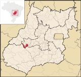
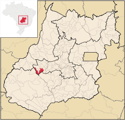
Ivolândia
Encyclopedia
| Ivolândia | |
|---|---|
| State | Goiás Goiás Goiás is a state of Brazil, located in the central part of the country. The name Goiás comes from the name of an indigenous community... |
| Area: | 1,262.837 km² (10/10/2002) |
| Population: | 2,718 (IBGE 2007) |
| Urban population: | 1,481 (2007) |
| Population density: | 2.15 inhab/km² (2007) |
| Elevation: | 637m above sea level |
| Postcode (CEP): | 76130-000 |
| Became a city: | 1953 |
| Mayor: | Noemi Gonçalves Freitas (January 2005) |
| IBGE statistical Microregion: | Iporá Microregion Iporá Microregion The Iporá Microregion is a geographical region in central-western Goiás state, Brazil. The most important city is Iporá. For a map see -Important Data :*Population: 58,845 *Cities: 10*Total Area: 7,096.60 km²... |
| Distance to Goiânia Goiânia -Climate:The city has a tropical wet and dry climate with an average temperature of . There's a wet season, from October to April, and a dry one, from May to September. Annual rainfall is around 1,520 mm.... : |
175 km. |
| Website: | none (March 2008) |
| Coordinates: | 16°36′48"S 50°46′40"W |
Town
A town is a human settlement larger than a village but smaller than a city. The size a settlement must be in order to be called a "town" varies considerably in different parts of the world, so that, for example, many American "small towns" seem to British people to be no more than villages, while...
and municipality
Municipality
A municipality is essentially an urban administrative division having corporate status and usually powers of self-government. It can also be used to mean the governing body of a municipality. A municipality is a general-purpose administrative subdivision, as opposed to a special-purpose district...
in eastern Goiás
Goiás
Goiás is a state of Brazil, located in the central part of the country. The name Goiás comes from the name of an indigenous community...
state, Brazil
Brazil
Brazil , officially the Federative Republic of Brazil , is the largest country in South America. It is the world's fifth largest country, both by geographical area and by population with over 192 million people...
. The population was 2,718 (2007) in a total area of 1,262.8 km² (10/10/2002).
Location
- Distance to regional center (IporáIporáIporá is a small city and municipality in west-central Goiás state, Brazil. The population was 31,060 in a total area of 1,026.4 km² . It is known as the City of the Clear Waters because of its many streams and rivers.-Location:...
): 56 km. - Highway connections: state highway BR-069 west from GoiâniaGoiânia-Climate:The city has a tropical wet and dry climate with an average temperature of . There's a wet season, from October to April, and a dry one, from May to September. Annual rainfall is around 1,520 mm....
, through TrindadeTrindade, GoiásTrindade is a city and municipality in Goiás state, Brazil. It is famous for the religious celebrations held there in July and is now the third most important pilgrimage site in Brazil....
, São Luís de Montes BelosSão Luís de Montes BelosSão Luís de Montes Belos is a small city and municipality in the State of Goiás, Brazil.-Location:It is located in the Anicuns Microregion, 123 kilometers from the state capital, Goiânia, to which it is connected by highway GO-060...
, GO-444 / MoiporáMoiporáMoiporá is a small town and municipality in eastern Goiás state, Brazil.-Distances and Highway Connections:*Distance to the state capital: 160 km.*Distance to regional center : 76 km....
. For the complete list for GoiásGoiásGoiás is a state of Brazil, located in the central part of the country. The name Goiás comes from the name of an indigenous community...
see Distancias Rodoviarias Seplan
Neighboring municipalities: Iporá
Iporá
Iporá is a small city and municipality in west-central Goiás state, Brazil. The population was 31,060 in a total area of 1,026.4 km² . It is known as the City of the Clear Waters because of its many streams and rivers.-Location:...
, Amorinópolis
Amorinópolis
Amorinópolis is a small town and municipality in eastern Goiás state, Brazil.-Location:The distance to the regional center of is 19 km....
, Cachoeira de Goiás
Cachoeira de Goiás
Cachoeira de Goiás is a small town and municipality in eastern Goiás state, Brazil.-Location:*Distance to the state capital: 172 km.*Distance to regional center : 77 km....
, Palestina de Goiás
Palestina de Goiás
Palestina de Goiás is a small town and municipality in eastern Goiás state, Brazil.-Location:Palestina is located in the Sudoeste de Goiás Microregion between the Rio Bonito and the Rio Caiapó. There are paved road connections linking the town to Jataí in the south and to Iporá in the northeast...
, Caiapônia
Caiapônia
Caiapônia is a small town and municipality in south-central Goiás state, Brazil. It has the third largest cattle herd in the state and is a major producer of grains. The town is also known as Torres Do Rio Bonito or just Rio Bonito.-Geography:...
, Moiporá
Moiporá
Moiporá is a small town and municipality in eastern Goiás state, Brazil.-Distances and Highway Connections:*Distance to the state capital: 160 km.*Distance to regional center : 76 km....
, Arenópolis
Arenópolis
Arenópolis is a small town and municipality in eastern Goiás state, Brazil. The population was 3,495 in a total area of 1,074.5 km².-Location and Connections with Goiânia:...
, and Paraúna
Paraúna
Paraúna is a small town and municipality in southwestern Goiás state, Brazil. It has strange rock formations and is a large producer of cotton and soybeans.-Location:...
.
Districts, villages, and hamlets
- District: Campolândia.
- Hamlets: Estrela do Oriente and Petrolandia.
Demographics
- Population growth rate 1996/2007: -1.31%
- Population in 1980: 4,269
- Population in 2007: 2,718
- Urban population in 2007: 1,481
- Rural population in 2007: 1,237 (Sepin)
The economy
The economy is based on services, cattle, milk products, and limited agriculture. There was 01 dairy—UNILAT - Indústria de Laticínios Ltda (07/06/2006). There were no bank branches in 2007. The cattle here had 93,000 head in 2006. The main agricultural crops were corn, manioc, rice, soybeans, and sugarcane.- GDP (PIB) (R$ 1,000.00): 20,240 (2005)
- GDP per capita (R$ 1.00): 6,796 (2005)
Motor vehicles
- Automobiles: 125
- Pickup trucks: 37
- Number of inhabitants per motor vehicle: 17
Agricultural data 2006
- Farms: 488
- Total area: 104,195 ha.
- Area of permanent crops: 39 ha.
- Area of perennial crops: 124 ha.
- Area of natural pasture: 76,909 ha.
- Area of woodland and forests: 25,015 ha.
- Persons dependent on farming: 1,600
- Farms with tractors: 83
- Number of tractors: 108
- Cattle herd: 93,000 head IBGE
Education and Health
- Schools in activity: 4
- Classrooms: 18
- Teachers: 29
- Total Students: 610
- Literacy Rate: 81.6%
- Hospitals: 1
- Beds: 16
- Public health clinics: 3
- Infant mortality rate: 24.39 (in 1,000 live births)
- Municipal Human Development IndexHuman Development IndexThe Human Development Index is a composite statistic used to rank countries by level of "human development" and separate "very high human development", "high human development", "medium human development", and "low human development" countries...
: 0.721 - State ranking: 169 (out of 242 municipalities in 2000)
- National ranking: 2.601 (out of 5,507 municipalities in 2000)
History
The opening up of these lands began in 1939 when several families from Minas GeraisMinas Gerais
Minas Gerais is one of the 26 states of Brazil, of which it is the second most populous, the third richest, and the fourth largest in area. Minas Gerais is the Brazilian state with the largest number of Presidents of Brazil, the current one, Dilma Rousseff, being one of them. The capital is the...
and Bahia
Bahia
Bahia is one of the 26 states of Brazil, and is located in the northeastern part of the country on the Atlantic coast. It is the fourth most populous Brazilian state after São Paulo, Minas Gerais and Rio de Janeiro, and the fifth-largest in size...
settled along the banks of the Rio Claro and the Córrego Encantado seeking gold and diamonds. In 1944 a dirt road was opened and a village was formed called Boa Vista, because of the location on the plateau between Iporá
Iporá
Iporá is a small city and municipality in west-central Goiás state, Brazil. The population was 31,060 in a total area of 1,026.4 km² . It is known as the City of the Clear Waters because of its many streams and rivers.-Location:...
and Cachoeira de Goiás
Cachoeira de Goiás
Cachoeira de Goiás is a small town and municipality in eastern Goiás state, Brazil.-Location:*Distance to the state capital: 172 km.*Distance to regional center : 77 km....
. In 1947 the first church dedicated to Nossa Senhora da Abadia was built and one year later came the first primary school. In 1952 Boa Vista was made a district of Aurilândia
Aurilândia
Aurilândia is a small town and municipality in eastern Goiás state, Brazil.-Location:The distance to the state capital is 146 km. while the distance to the main regional center São Luís de Montes Belos is 23 km....
and the name was changed to Ivolândia, in homage to the pioneer Ivo Moreira Neves. In 1953 it was raised to municipal status.