
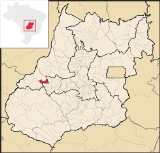
Diorama, Goiás
Encyclopedia
| Diorama | |
|---|---|
| State | Goiás Goiás Goiás is a state of Brazil, located in the central part of the country. The name Goiás comes from the name of an indigenous community... |
| Area: | 687 km² |
| Population: | 8,372 (IBGE 2007) |
| Urban and Rural Population: | 2,236 / 841 |
| Population density: | 3.25 inhab/km² (2007) |
| Elevation: | 506 m above sea level |
| Postcode (CEP): | 76260-000 |
| IBGE statistical microregion: | Aragarças Microregion Aragarças Microregion The Aragarças Microregion is a geographical division in Goiás state, Brazil. It consists of 7 municipalities located near Aragarças in western Goiás. For a map see -Important Data :*Population: 53,541*Cities: 7*Total Area: 11,091.90 km²... |
| Became a city: | 1958 |
| Mayor: | Altamiro José de Lima |
| Distance to Goiânia Goiânia -Climate:The city has a tropical wet and dry climate with an average temperature of . There's a wet season, from October to April, and a dry one, from May to September. Annual rainfall is around 1,520 mm.... : |
254 km. |
| Website: | none |
| Coordinates: | 16°14′10"S 51°15′31"W |
Town
A town is a human settlement larger than a village but smaller than a city. The size a settlement must be in order to be called a "town" varies considerably in different parts of the world, so that, for example, many American "small towns" seem to British people to be no more than villages, while...
and municipality
Municipality
A municipality is essentially an urban administrative division having corporate status and usually powers of self-government. It can also be used to mean the governing body of a municipality. A municipality is a general-purpose administrative subdivision, as opposed to a special-purpose district...
in eastern Goiás
Goiás
Goiás is a state of Brazil, located in the central part of the country. The name Goiás comes from the name of an indigenous community...
state, Brazil
Brazil
Brazil , officially the Federative Republic of Brazil , is the largest country in South America. It is the world's fifth largest country, both by geographical area and by population with over 192 million people...
.
Location and Connections
Diorama is 254 kilometers west of the state capital, GoiâniaGoiânia
-Climate:The city has a tropical wet and dry climate with an average temperature of . There's a wet season, from October to April, and a dry one, from May to September. Annual rainfall is around 1,520 mm....
, and is 30 kilometers west of the regional center, Iporá
Iporá
Iporá is a small city and municipality in west-central Goiás state, Brazil. The population was 31,060 in a total area of 1,026.4 km² . It is known as the City of the Clear Waters because of its many streams and rivers.-Location:...
. Neighboring municipalities are Montes Claros de Goiás
Montes Claros de Goiás
Montes Claros de Goiás is a small town and municipality in western Goiás state, Brazil-Location and connections:Montes Claros is located in the extreme west of the state, about 70 km east of the Araguaia River. It is east of Aragarças and west of Jussara.Montes Claros is connected by poor...
, Arenópolis
Arenópolis
Arenópolis is a small town and municipality in eastern Goiás state, Brazil. The population was 3,495 in a total area of 1,074.5 km².-Location and Connections with Goiânia:...
, Iporá
Iporá
Iporá is a small city and municipality in west-central Goiás state, Brazil. The population was 31,060 in a total area of 1,026.4 km² . It is known as the City of the Clear Waters because of its many streams and rivers.-Location:...
, and Israelândia
Israelândia
Israelândia is a small town and municipality in eastern Goiás state, Brazil.-Location:Israelândia is located in the Iporá Microregion, 28 km. northeast of regional center Iporá. State capital Goiânia is 199 km. to the east...
.
Highway connections from Goiânia
Goiânia
-Climate:The city has a tropical wet and dry climate with an average temperature of . There's a wet season, from October to April, and a dry one, from May to September. Annual rainfall is around 1,520 mm....
are made by GO-060 / Trindade
Trindade, Goiás
Trindade is a city and municipality in Goiás state, Brazil. It is famous for the religious celebrations held there in July and is now the third most important pilgrimage site in Brazil....
/ Nazário
Nazário
Nazário is a small town and municipality in eastern Goiás state, Brazil.-Location:Nazário is located 74 km. west of the state capital, Goiânia a few kilometers west of the Rio dos Bois, a major tributary of the Paranaíba River. The regional center, Anicuns, is 21 km to the northwest...
/ São Luís de Montes Belos
São Luís de Montes Belos
São Luís de Montes Belos is a small city and municipality in the State of Goiás, Brazil.-Location:It is located in the Anicuns Microregion, 123 kilometers from the state capital, Goiânia, to which it is connected by highway GO-060...
/ Israelândia
Israelândia
Israelândia is a small town and municipality in eastern Goiás state, Brazil.-Location:Israelândia is located in the Iporá Microregion, 28 km. northeast of regional center Iporá. State capital Goiânia is 199 km. to the east...
/ Iporá
Iporá
Iporá is a small city and municipality in west-central Goiás state, Brazil. The population was 31,060 in a total area of 1,026.4 km² . It is known as the City of the Clear Waters because of its many streams and rivers.-Location:...
/ GO-174.
The economy
The economy is based on agriculture, livestock raising, and wood processing. In 2007 there were 2 small transformation industries and 24 commercial units. There were 59,000 head of cattle. Agricultural production was modest with small areas of rice, bananas, beans, sugarcane, corn and soybeans.Agricultural data 2006
- Number of farms: 391
- Total area: 48,159 ha.
- Area of permanent crops: 30 ha. (bananas)
- Area of perennial crops: 557 ha. (soybeans, corn, rice)
- Area of natural pasture: 36,229 ha.
- Area of woodland and forests: 10,988 ha.
- Cattle herd: 59,000
- Number of workers: 730
- Number of farms with tractors: 58
- Number of tractors: 70 IBGE
Education and health
- Literacy rate: 83.5%
- Infant mortality rate: 21.93 in 1,000 live births
- Schools: 05 (2006) with 695 students
- Hospitals: 01 with 26 beds (2007)
- Municipal Human Development IndexHuman Development IndexThe Human Development Index is a composite statistic used to rank countries by level of "human development" and separate "very high human development", "high human development", "medium human development", and "low human development" countries...
: 0.733 - State ranking: 135 (out of 242 municipalities in 2000)
- National ranking: 2,363 (out of 5,507 municipalities in 2000)
History
Settlement began in 1946 on lands belonging to the municipality of IporáIporá
Iporá is a small city and municipality in west-central Goiás state, Brazil. The population was 31,060 in a total area of 1,026.4 km² . It is known as the City of the Clear Waters because of its many streams and rivers.-Location:...
. A local rancher, Edmundo Benuto Dias donated land for a new settlement, which was called "Aropi", the inversion of the name "Iporá". In 1954 it was elevated to the category of district with the new name of Mendelândia, after Antônio Mendes, one of the pioneers of the region. In 1955 the name was changed to Diorama, of unknown origin. In 1958 it became a municipality.