
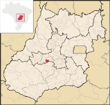
Turvânia
Encyclopedia
| Turvânia | |
|---|---|
| State | Goiás Goiás Goiás is a state of Brazil, located in the central part of the country. The name Goiás comes from the name of an indigenous community... |
| Area: | 472.3 square kilometre |
| Population: | 4,977 (IBGE 2005) |
| Elevation: | 659 m (2,162.1 ft) above sea level |
| Postcode (CEP): | 76110-000 |
| IBGE statistical microregion: | 009 Anicuns Microregion Anicuns Microregion The Anicuns Microregion is a geographical division in the state of Goiás, Brazil. It is made up of 13 municipalities located near Anicuns, a small city and municipality west of Goiânia... |
| Became a city: | 1958 |
| Mayor: | Rubens Severino de Aguiar |
| Distance to Goiânia Goiânia -Climate:The city has a tropical wet and dry climate with an average temperature of . There's a wet season, from October to April, and a dry one, from May to September. Annual rainfall is around 1,520 mm.... : |
99 km (61.5 mi) |
| Website: | none |
| Geographical coordinates: | 16°36′23"S 50°08′14"W |
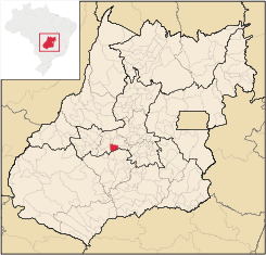
Municipality
A municipality is essentially an urban administrative division having corporate status and usually powers of self-government. It can also be used to mean the governing body of a municipality. A municipality is a general-purpose administrative subdivision, as opposed to a special-purpose district...
in eastern Goiás
Goiás
Goiás is a state of Brazil, located in the central part of the country. The name Goiás comes from the name of an indigenous community...
state, Brazil
Brazil
Brazil , officially the Federative Republic of Brazil , is the largest country in South America. It is the world's fifth largest country, both by geographical area and by population with over 192 million people...
.
Location
Turvânia is located west of GoiâniaGoiânia
-Climate:The city has a tropical wet and dry climate with an average temperature of . There's a wet season, from October to April, and a dry one, from May to September. Annual rainfall is around 1,520 mm....
, 28 km (17.4 mi) east of São Luís de Montes Belos
São Luís de Montes Belos
São Luís de Montes Belos is a small city and municipality in the State of Goiás, Brazil.-Location:It is located in the Anicuns Microregion, 123 kilometers from the state capital, Goiânia, to which it is connected by highway GO-060...
.
Highway connections from Goiânia
Goiânia
-Climate:The city has a tropical wet and dry climate with an average temperature of . There's a wet season, from October to April, and a dry one, from May to September. Annual rainfall is around 1,520 mm....
are made by state highway BR-069 west from Goiânia
Goiânia
-Climate:The city has a tropical wet and dry climate with an average temperature of . There's a wet season, from October to April, and a dry one, from May to September. Annual rainfall is around 1,520 mm....
, through Trindade
Trindade
-Transportation:Trindade are linked with São Tomé and Príncipe's only highways linking to the capital city of São Tomé, another linking Neves and Santana and another linking to Guadalupe as well....
, Santa Bárbara de Goiás
Santa Bárbara de Goiás
Santa Bárbara de Goiás is a small town and municipality in eastern Goiás state, Brazil.-Location:Santa Bárbara is located due west of Goiânia. Nearby towns are Trindade , and Nazário is 25 km...
, and then 50 kilometers west to Turvânia. Neighboring municipalities are Firminópolis
Firminópolis
Firminópolis is a small town and municipality in eastern Goiás state, Brazil.-Location and connections:*Distance to São Luís de Montes Belos: 9 km....
, São Luís de Montes Belos
São Luís de Montes Belos
São Luís de Montes Belos is a small city and municipality in the State of Goiás, Brazil.-Location:It is located in the Anicuns Microregion, 123 kilometers from the state capital, Goiânia, to which it is connected by highway GO-060...
, Adelândia
Adelândia
Adelândia is a small town and municipality in eastern Goiás state, Brazil.-Location:The distance to the state capital Goiânia is 129 km. while the distance to the regional center São Luís de Montes Belos is 6 km....
, Nazário
Nazário
Nazário is a small town and municipality in eastern Goiás state, Brazil.-Location:Nazário is located 74 km. west of the state capital, Goiânia a few kilometers west of the Rio dos Bois, a major tributary of the Paranaíba River. The regional center, Anicuns, is 21 km to the northwest...
and Anicuns
Anicuns
Anicuns is a small city and municipality in central Goiás state, Brazil.-Geographical Facts:Anicuns is located in the Anicuns Microregion, which includes 13 cities with a population of 103276 inhabitants in a total area of 5483.10 km²....
.
Demographics
The population density was 10.51/km2 (27.2/mi2) (2007). The urban population was 4,036 (2007) and the rural population was 926.The economy
The economy is based on subsistence agriculture, cattle raising, services, public administration, and small transformation industries. There was one dairy in 2007. The cattle herd had 65,000 (2006). The main crops were rice, bananas, sugarcane (2,200 hectares; 5,400 ac), beans, manioc, corn, tomatoes, and soybeans.Health and education
The adult literacy rate was 85.5% (2000) (the national average was 86.4%). There were 2 hospitals with 37 beds. The infant mortality rate was 26.08 (2000) (the national average was 33.0). The classification on the Municipal Human Development IndexHuman Development Index
The Human Development Index is a composite statistic used to rank countries by level of "human development" and separate "very high human development", "high human development", "medium human development", and "low human development" countries...
was 0.736 (state ranking: 122 out of 242 municipalities and national ranking of 1,267 out of 5,507 municipalities. For the complete list see frigoletto.com.br